
WXinCanton
-
Posts
3,781 -
Joined
-
Last visited
Content Type
Profiles
Blogs
Forums
American Weather
Media Demo
Store
Gallery
Posts posted by WXinCanton
-
-
26 minutes ago, chapelhillwx said:
Took a personal day and going to be chasing this one Sunday am into Monday. Will be interesting to see where to go. Asheville would be convenient from Atlanta but I’m not sure that’s failsafe. Any ideas guys? Glad to be back on the forum again!
I'm looking at Highlands, NC. Nice town and sits at 4,100 ft. They should get smoked, closest spot to Atlanta in my opinion. OF course subject to change
-
3 hours ago, Orangeburgwx said:
CFS is garbage so completely ignore it this time around... EPS had a garbage run so it is highly suspect, go look at the post Big Frosty put in the Sanatarium channel for a detailed outlook

Where is the Sanatarium channel?
-
Those wind gust maps are historically way overdone.
-
 1
1
-
-
Just now, burrel2 said:
Hrrr is cranking a stationary band of snow associated with the upper level low all night in to tomorrow morning across the upstate/nc mountains/ and georgia. Anybody have thoughts on this feature?

-
 1
1
-
-
4 minutes ago, DixieBlizzard said:
Hey, @WXinCanton, check this out my friend. I have been in Ellijay for a year now. This looks good for our areas!
Yes it does! Emerson looks good too, crazy to go from being fringed to stop going North! Hope all is well.
-
1
-
-
SREF plumes mean is about the same for Gainesville, just over an inch.
-
2 minutes ago, CummingGaSnow said:
Hey where in Canton are you? I'm on the NW side of Cumming. Looks like you and I will be right on the edge of where the colder temps meet the lightest of precip. What are you thinking for our areas?
Hickory Flat area. We need QPF and precip to come NW vs current guidance. I would go with a car topper or deck dusting with what we have now, we are on the edge of a very sharp precip cutoff.
-
6 minutes ago, mackerel_sky said:
Atleast mention the chance, which he did not. There are absolutes in weather, so when they say "zero" chane of anything, it's annoying and not helpful to the public at all
Please tell me about the absolutes.
The mind of a weenie, we all have it. I'm guilty
-
9 minutes ago, mackerel_sky said:
But he said zero flakes outside the mountains yesterday!?
Just curious, what should he have said yesterday? I'm sure you know there a ramifications being a broadcast met?
-
1
-
-
1 minute ago, magoos0728 said:
Any reason why KFFC has been quiet lately?
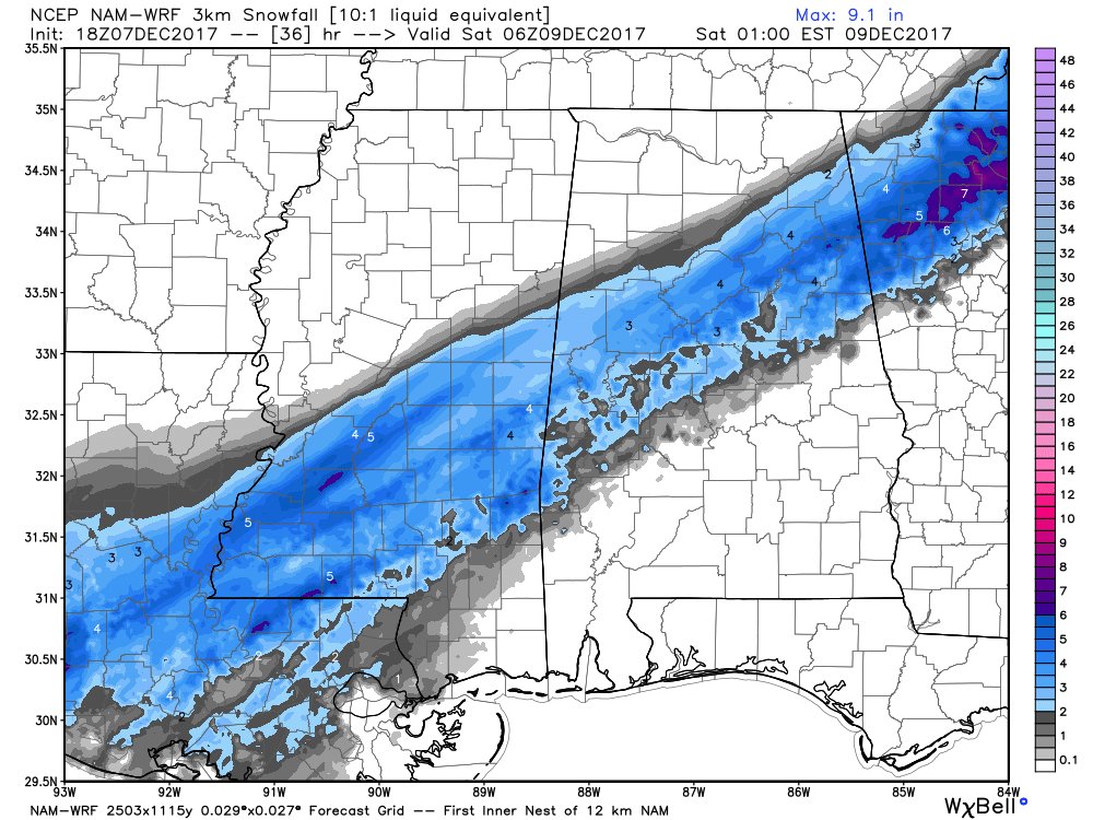
FXUS62 KFFC 062043
AFDFFC

Area Forecast Discussion
National Weather Service Peachtree City GA
343 PM EST Wed Dec 6 2017


...Potentially Hazardous Winter Weather Scenario Late Thursday
Night Through Saturday Morning...

.SHORT TERM /Tonight through Thursday Night/...

Interesting but far from certain forecast over the next few days.
Region remains in a cold pattern with a series of waves moving
through the region. First wave brought the rain (and even some brief
periods of sleet) to all but northwest Georgia today. Indications
are that the next wave and surge of precipitation tomorrow into the
beginning of the extended forecast period, Friday/Friday night, will
be similar in distribution. Difference will be the temperature
profiles and therein lies the uncertainty. Right now it looks like
we start out tomorrow through much of tomorrow night with a cold
rain with some snow mixing in across west-central and north Georgia
by Friday morning. There is some potential for accumulations along
and north of the I-85 corridor by sun-up Friday, but that area
should be seeing fairly light precipitation amounts in that time
frame. We will need to keep a close eye on how the future runs of
the medium range models come together. For now confidence is not
high enough in the next 36 hours for any advisories or watches.

20
-
1
-
-
it's weather people, not the end of the world, lmao
-
22 hours ago, mackerel_sky said:
So done with all this SH!T! Will never track another storm again, Mack . Out
Lol, classic meltdown
-
I need to go to PR to get my head straight
-
1 minute ago, Cold Rain said:
Wow! We're desperate if we're pulling out the German model.
Nein snow for you!!
Bahaha lol
-
13 minutes ago, Queencitywx said:
People take it personal when people like Burns and Michelle try and clean up that disco thread but we just dont need that garbage in there for a reason.
Totally agree, I've seen it happen many times. It make me LOL, when all the regular members flock to Banter to escape.
-
Always great when the Banter threads get better info than the discussion thread. When the discussion thread runs into a sh!t show.
-
I like all storms. Ice storms can be very beautiful.
That said, I personally have not had a huge impact from any ice or frozen rain storms (yet). So I'd probably change my opinion if I went a week without power and heat.
We were very close last year. Dawson county got nailed. That said, I like them all. I'll take a quarter inch of ZR over rain any day.
-
I like any weather events. I would take snow over ZR, but I would take ZR over rain.
-
I thought you were a lot younger.
SMH
-
Didn't we meet at the SE GTG a few years back at mountain marvels place? I remember you with hair man.
I wasn't at that one. Though I have chopped my hair lol
-
Watching the Bears get crushed by Cowboys Thursday night

-
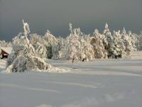
I love Brasstown Bald! I'll be getting up there once we get some color in the next couple weeks
-
Looks like they were having a great time
 They are adorable
Thank you!! They didn't want to go, the wanted to watch TV. But when we got there, they were walking in the waterfalls and had a blast. They didn't want to leave

-
My two girls this past weekend.

Tropical Storm Henri
in New England
Posted