

EverythingisEverything
-
Posts
100 -
Joined
-
Last visited
Content Type
Profiles
Blogs
Forums
American Weather
Media Demo
Store
Gallery
Posts posted by EverythingisEverything
-
-
4 hours ago, RVASnowLover said:
Well the euro was really good
Even getting interesting for SEVA again.
-
10 minutes ago, Beach Snow said:
From DT on twitter. As much as i don’t like him he has a point. Wonder if this will cause implications for the Friday event?
Uh oh
-
1 minute ago, burgertime said:
Looking at it you can't help but wishcast into phasing sooner. It's so close to looking spectacular for all of you in ENC. Rooting it keeps inching closer to something bigger.
How is it looking for SE VA?
-
 1
1
-
-
15 minutes ago, VARTV said:
You just jinks us!

Lol why what happened?
-
7 minutes ago, VABILLUPS1 said:
About 30 hours continuous snow on the 12z NAM for SE Virginia from around midnight Friday to Saturday morning - model now combines the FROPA snow and the 2nd wave. Close to an all-timer if it verifies.
Va Beach here....looks like this may really happen.
-
3 hours ago, Stormpc said:
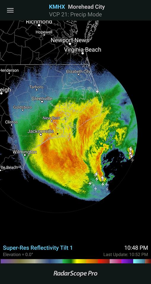
Looks like a pretty good band is near/over Newport News right now. Too bad we don't have many in this form in the Hampton Roads area.
Va Beach saw some snow mixed in this evening around 5pm. Let's see how this "bay effect" snow sets up overnight for us.
-
 1
1
-
-
Virginia Beach cold rain.
-
- Do you think SE VA is done with its acummulating snow chances this winter?
-
2 hours ago, tramadoc said:

Imma just leave this right here for everyone to s**t their pants over.
Sent from my iPad using TapatalkThat would be so nice! Moderate snow coming down Virginia Beach 23456
-
22 minutes ago, ldub23 said:
Just checked Wakefield and they are only saying a few snow showers are possible in NE forecast area Tues.
.LONG TERM /MONDAY NIGHT THROUGH FRIDAY/...
Low confidence forecast beyond Monday as 12z/11 suite of models
are having a difficult time in resolving differences wrt
handling of a strong upper trough/closed low digging across the
Great Lakes/Northeast next week. Will lean toward a blend of the
12z GFS/GEFS/CMC which all seem to be in reasonable agreement
with the aforementioned trough/closed low pivoting SE to a
centralized position over Lake Erie by 12z Tues. From there,
this feature slowly lifts NE into New England by 12z Thurs. In
doing so, it will force a cold front through the local area on
Tues with high pressure returning next Wed/Thu. What remains to
be seen as whether or not the front produces any pcpn as it
passes on Tues, as it would probably be cold enough aloft to
generate some snow showers (at least NE of the I-64 corridor).
Have placed some low PoPs in these areas. Otherwise, next week
is looking dry and chilly. Highs Monday from the mid 30s N to
low 40s S. Highs Tuesday from the mid 30s N to the mid 40s
south. Highs next Wed/Thu in the 30s. Lows through the period
primarily in the teens and 20s.
Thats from the afternoon disco
More model runs to see how it may play out. Not sure if people in SEVA are ready to see more snow. I don't mind at all lol.
-
6 minutes ago, DownS.EasternVa said:
Yea unreal, I would consider boxing day a blizzard too, even without warnings. I felt slighted last year sleet killed the totals. But this baby is the real deal and still pouring.
Yes this was the real deal of a storm. Glad I was able to experience it. Hope everybody who lost power in the area, will have it restore very soon.
-
You would think it was a hurricane. wow

-
Wind swept snow here in virginia beach. Good Times.
-
All snow here now. 23456. Coming down moderate to heavy.
-
More snowflakes taking over and larger ones at that.
-
-
6 minutes ago, VBsurf said:
Yea tell me about it. Its been all rain here near Red Mill, Virginia Beach 23456. Only good thing is I know we will go to snow eventually but hoping before midnight.
it snowing heavy all around us Ches Norfolk Portsmouth, but that rain line is right in va beach.
-
This mix is going to kill us here in VB.
-
Snow and Sleet 23456 ugh!
-
5 minutes ago, Fishallot said:
I had moderate snow here about 1.5 miles East of ORF b/n 3:00 - 3:20 this afternoon, just enough to turn the driveway and yard white. Hunkered down and ready for some big snowfall later tonight. I noticed WAVY finally upped the totals for this storm to 8" - 10". WoooHooooo!!!!!
Can't believe Hampton Roads is in a great position to cash in on some good snows! Awaiting, will be up most of the night.
-
2
-
-
6 minutes ago, VBsurf said:
Odds we get bumped up to a Blizzard Warning? Interesting we have a gale watch right off the coast. Really cant see another scenario of lower pressure, stronger winds or heavier precip than what is being shown.
I agree...Blizzard Warning possibility
-
Just watched Jeremy Wheeler on Wavy TV 10, he ran their in house model and said well it basically took the snow away after a brief mix, but said he doesn't think it's right. He seemed unsure of the forecast but went ultimately with 2 to 4 for SEVA with mixing in the beginning.
-
16 minutes ago, Suffolkweather said:
Snow becoming more and more likely for SE VA. Euro, CMC, GFS, RGEM and NAM all onboard. NAM has a very strange precip field considering position/strength of low and overall track. The others have significant snow 4+". I'm rooting for the Euro 6+! Could this become major? Synopically odd to see a winter storm generate in the Bahama region, move NNE and bring us major snow to SE VA though. It will be interesting to watch.
16 minutes ago, Suffolkweather said:Snow becoming more and more likely for SE VA. Euro, CMC, GFS, RGEM and NAM all onboard. NAM has a very strange precip field considering position/strength of low and overall track. The others have significant snow 4+". I'm rooting for the Euro 6+! Could this become major? Synopically odd to see a winter storm generate in the Bahama region, move NNE and bring us major snow to SE VA though. It will be interesting to watch.
Hope there are no mixing issues for SEVA


Richmond Metro/Hampton Roads Discussion
in Mid Atlantic
Posted
SE VA here. Hoping you guys can get one!