

irvingtwosmokes
-
Posts
179 -
Joined
-
Last visited
Content Type
Profiles
Blogs
Forums
American Weather
Media Demo
Store
Gallery
Posts posted by irvingtwosmokes
-
-
-
1 hour ago, sauss06 said:
I've been soaked and dried like 5 times since 5 am, i bet i smell wonderful
 this go out then in is killing me. i come inside and get chilled. I'd rather just stay out. I need a beer and a pool.
Welcome to Louisiana.

-
 1
1
-
-
8 minutes ago, Mailman said:
Guess it's going to get fairly warm after the remnants of Barry roll through. Personally, I think a bigger deal is being made out of it than need be. But hey.. I like it when people are talking about the weather.
They way they have whiffed on this thing. I get this strange feeling one of those training bands is going to sit right on Johnstown.
-
48 minutes ago, canderson said:
You can order all that from HEB. I have spicy ketchup and jalapeño ranch always on reserve in the pantry.
The last two times I've been down, I've got it at Brookshires for $1.25 a bottle
-
 1
1
-
-
36 minutes ago, canderson said:
Going back for a week in August, want anything from home?
")
I'm driving down next Wednesday for 10 days. Thanks for the offer

I'm definitely coming home with some Whataburger mustard
-
6 hours ago, canderson said:
Growing up in Dallas everyone talked about the summer of 1980 and how it was just relentless heat. Every July day was 100+ and that summer Dallas had 28 days above 105. I was born in 81 so just missed out!
In the early 90s we had some terrible summers where we would always get a string of 103+ days but it'd be broken up by mid 90s.
2011 was a brutal Texas summer too but nothing will top 1980 in Dallas.
I was 17 at the time and it was BRUTAL!!!!
-
1
-
-
46 minutes ago, Anduril said:
Thanks. Might have to wait for it to go on sale
Prime Day is coming up July 15th-16th, so watch the price.
I just looked, Ambient Weather has it for $129
-
1 hour ago, Anduril said:
So is there a decent weather station set for under $150 (maybe even down to $100ish) since I now have a back yard to set it up in?
also...again this weather sucks lol
I got this in Feb on Amazon for $120, but didn't get it up and running till the first week in April.
-
1 hour ago, canderson said:
One of my favorite graphics of all time.
You a member at Surly, by chance?
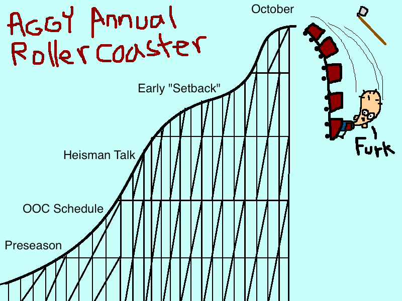
I'm a Shag/Surly vet, In fact it was Thujone's 2010 NC game MS Paint that made me join.
-
1
-
-
47 minutes ago, canderson said:
Never. Ever. I don't do cults. Little brother has lots of issues.
Yeah they have issues and they got dumped on us. It took 7 OT's to beat us, with along some shady SEC officiating. You would have thought they won the National Championship. I'm looking forward to Sept 7th @ 40 Acres
-
20 hours ago, canderson said:
DAMNIT. I enjoyed the winter posts bitching about the apartment snow removal.
The worst experience is moving into a University of Texas apartment when it’s 107 and the A/C isn’t on.
Thank God, you're not aggie
-
6 hours ago, pawatch said:
Who got 135" of snow to the south west Wow!!
That would likely be between Ogletown and Blue Knob
-
1 hour ago, canderson said:
It used to never bother me - playing football at 3 p.m. when it’s 105 and humid? Ok!
Today if it’s 85+ I want to die.
Everytime I go to Shreveport, I wonder how I grew up in that. I damn near can't breath when I go down there.
-
6 hours ago, sauss06 said:
deep, very deep down you know you love it

We're both from the same area, of course he loves it
-
1
-
-
2 hours ago, sauss06 said:
i'm not even sure our chance of rain today is that great. Upcoming could be our longest stretch of no rain in some time.
Good, it needs to dry OUT!!!
-
1
-
-
1 hour ago, sauss06 said:
Question- What weather station do you have and would you recommend it, or would you chose another and why?
Ambient Weather WS-2902A. I have no problems with it and recommend
https://dashboard.ambientweather.net/devices/public/fb42e95e9198d14a3fc071bd0f34b798
-
1
-
-
You got another one coming MAG
-
1 hour ago, Flatheadsickness said:
Then you will love this Mr. Atom I may have to break out the Cookies and Chem Dawg cross for this one.
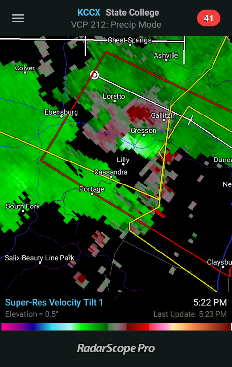
Multiple ingredients are present Thursday afternoon and evening for a rather significant severe storm outbreak with numerous fast-moving supercells and mini bow echoes within short TSRA lines. SPC upgraded the previous Slight Risk for Day 2 to an Enhanced Risk for much of our CWA. This upgrades seems warranted as llvl directional shear is impressive and strong leading to broad-loop hodographs and the base of 50kt westerly and WNW winds only around 5KFT agl during the mid afternoon to early evening hours Thursday. This is a classic supercell and potential large hail-producing environment as storm relative inflow/updraft helicity will be unusually high INVOF sfc warm front/lee trough across Ncent PA and the Susq Valley during the afternoon hours. Low LCLs under 3000 FT AGL covering much of Central and Eastern PA and strong LLVL shear will lead to 0-1km EHIs of 2-4(m^2/sec^2) near the warm front/lee trough over the central and eastern zones between 21Z Thu and 00Z Fri. The threat of several tornado-producing supercells will occur across this same region from mid afternoon to around dusk. In addition to the anticipated hail and isolated tornado threat, the supercells and their strong updrafts will occasionally collapse into fast moving mini bow/spearhead echoes that have the potential for producing localized, straight line winds in excess of 75 mph and swaths of wind damage. Storm total QPF will likely average between 3 and 6 tenths of an inch given the fast storm motion. Localized one inch amounts are possible where two or more TSRA occur. In the wake of the Thursday`s active weather, a slightly cooler and drier day is in store for Friday. By Saturday the humidity will begin to return along with a chance of mainly diurnal showers/storms. as a weak shortwave once again races over the top of the eastern ridge. We look to get a break on Sunday as the 12Z models show a mainly dry day, but by the Monday-Tuesday timeframe more showers become possible as we stay in fast flow aloft near the top of the subtropical ridge.
Someone has been to DC
-
Whatever happened to the Weather Channel this morning sure screwed them up
-
1 hour ago, canderson said:
I’m in East Texas - Saturday looks like a legit TOR chance here.
Looks like you're going to be rockin. I'll be that way in 3 weeks
-
1 hour ago, MAG5035 said:
If I end up with another sleet storm like last week I'd have a snowpack til April no matter what the weather did haha.
The 7" of solid ice beneath the snow is crazy.
-
It's really coming down
-
1 minute ago, kerplunk said:
Nice! Were those cars bare to start?
Yeah they were bare. I had to pull the battery out of the Mustang yesterday to charge it. the Mustang is surrounded by 6" glacier...lol
-
1 minute ago, pasnownut said:
wow. fantastic!! Enjoy

Those 2 benches were bare at 4 am
-
1
-


Central PA Spring/Summer 2019
in Upstate New York/Pennsylvania
Posted
It's not terribly bad back home right now.