

cheapdad00
-
Posts
66 -
Joined
-
Last visited
Content Type
Profiles
Blogs
Forums
American Weather
Media Demo
Store
Gallery
Posts posted by cheapdad00
-
-
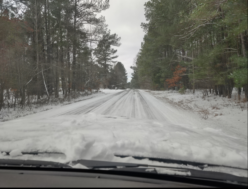
3" here in NW Cary. Pic below of the heavy band that came through around midnight last night. Also, a snow covered road near Jordan Lake during today's snow drive. While driving near the lake had a Honda CR-V headed in other direction spin out, over correct and end up in a ditch.

-
 3
3
-
-
5 hours ago, Cheeznado said:
Josh Morgerman, crazy person, is right in the path on Great Abaco Island. https://twitter.com/iCyclone
Just read his tweets. He has children with him, holed up in Marsh Harbour.
-
1 hour ago, jburns said:
I still have problems accepting taking maps 2 weeks out even remotely seriously. A few years ago you would have been tarred and feathered for even posting a single map that far out. I also don't buy how much better the models have gotten as a reason. There hasn't been a single storm that I can remember where we knew three days out what was going to happen. Besides, at my age, you don't look too far ahead. Hell, I don't even buy green bananas.
I would tend to agree, but didnt the mid range models do well with the December storm? They held it together for a good week ahead, albeit with bullseye gyrations of a couple hundred miles over the course of the runup.
-
1 hour ago, NCSNOW said:
Mack is never gonna forget this wintrer if the tide doesnt change soon.
His 2 favorite teams:
Clemson wins it all football
Duke will win it all basketball
Brick will have over a foot of snow while his backyard gets skunked.
D00k isnt winning the natty....
-
3
-
-
7" in western wake county at the Chatham county line. Light precip now, hear some pingers. Just got back from a drive and Town of Cary has plowed all the non-neighborhood roads around here. McDonalds was open. Almost got backed into by a snowplow in the Harris Teeter parking lot.
-
1
-
-
30 minutes ago, cbmclean said:
To me, it seemed that he was quite stung by the outcry after the Jan 2016 debacle (much of which was undeserved in my opinion). I half wonder if that experience may have added a bit to his conservatism.
It was Dec 2000. In an attempt to not miss out on a Carolina crusher redux, he went all in with huge totals all over the triangle (I think there was a 12-18"+ band on his call map). Woke up the next morning to sunny skies and what there was of the storm had skipped over us and was snowing in the coastal plain (and not nearly that much snow).
Ever since then he has been conservative with what he shows on air.
Here is a write up on the storm:
https://projects.ncsu.edu/atmos_collaboration/nwsfo/storage/cases/20001203/
-
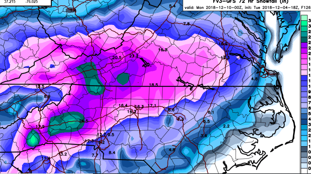
1 hour ago, Poimen said:
FV 3 Kuchera through 0Z Mon.

A Leeside minimum on the Chatham/Wake county line?
-
4 minutes ago, ncskywarn said:
SUMMARY OF 1000 PM EDT...0200 UTC...INFORMATION
----------------------------------------------
LOCATION...34.0N 76.7W
ABOUT 50 MI...80 KM S OF MOREHEAD CITY NORTH CAROLINA
ABOUT 70 MI...115 KM ESE OF WILMINGTON NORTH CAROLINA
MAXIMUM SUSTAINED WINDS...100 MPH...160 KM/H
PRESENT MOVEMENT...NW OR 305 DEGREES AT 5 MPH...8 KM/H
MINIMUM CENTRAL PRESSURE...956 MB...28.23 INCHES
So to sort out this direction discussion, West is 270 degrees, North is 360 degrees (or 0). NW would be halfway between at 315 degrees. WNW would be halfway between W and NW, so 292.5 degrees.
So Florence is considered as moving NW because 305 degrees is closer to 315 (NW) than it is to 292.5 (WNW)?
-
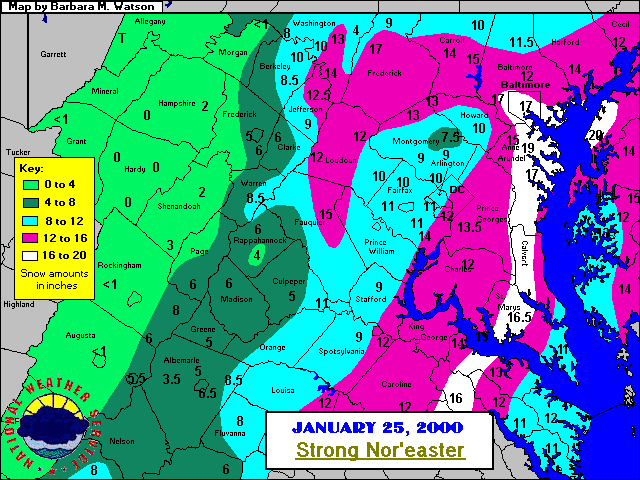
I went with January 25, 2000 because it was a total surprise up until 9 or 10pm that evening. I remember watching my local forecast on TWC and when I saw the radar the precip looked like it was moving due north. I kept checking and checking and thinking, this is coming due north, I thought it was supposed to miss us. Sure enough at about 9 pm the red winter storm bulletin with that loud annoying siren noise came on TWC. I went from 4-8, then a couple hours later 8-12 then finally 12-16. My brothers and I were jumping for joy at around midnight that evening lol. It wasn't the most snow but it put me in the bullseye along the western part of the bay.
This was 2nd on my list because I was in Chapel Hill at the time. We were told we might get a couple of inches, started out as rain around 10PM, woke up with 20" on the ground at 10AM. Crazy rates, a shame it didnt happen during the day. The whole area turned into a solid sheet of ice as temps dropped close to zero at night as if North Carolina was Siberia.
-
Overall for the entire Mid-Atlantic I would go 1/96.
As for the area I live in now I would go 2/9-10/2010
I think 2/83 should be given more consideration. It wasn't a long duration event like most of the others which meant it was sustained 2 inch per hour rates for many consecutive hours. Lightning and thunder with some areas reporting 3-4 inch per hour rates. Most of the region received 2 feet of snow in roughly 14-16 hour period.
2/83 was my vote, first time I ever saw thundersnow. Crazy snow rates. Ended up with 2 ft in Annapolis.


Mid to Long Range Discussion ~ 2022
in Southeastern States
Posted
Dec 2000 still haunts him to this day.