

1bert1
-
Posts
99 -
Joined
-
Last visited
Content Type
Profiles
Blogs
Forums
American Weather
Media Demo
Store
Gallery
Posts posted by 1bert1
-
-
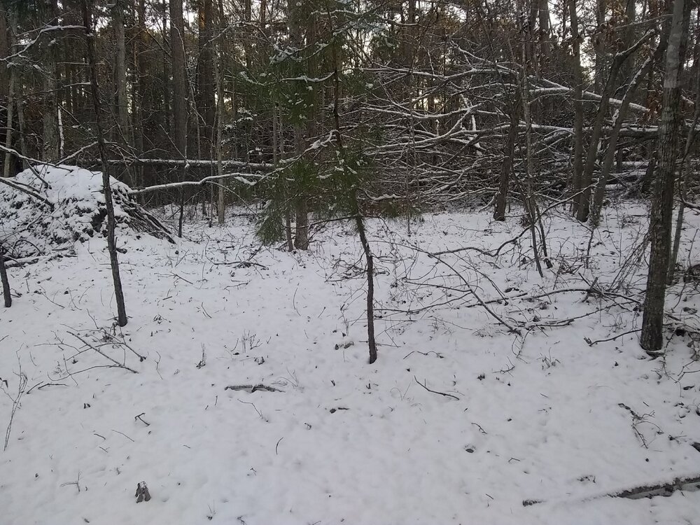
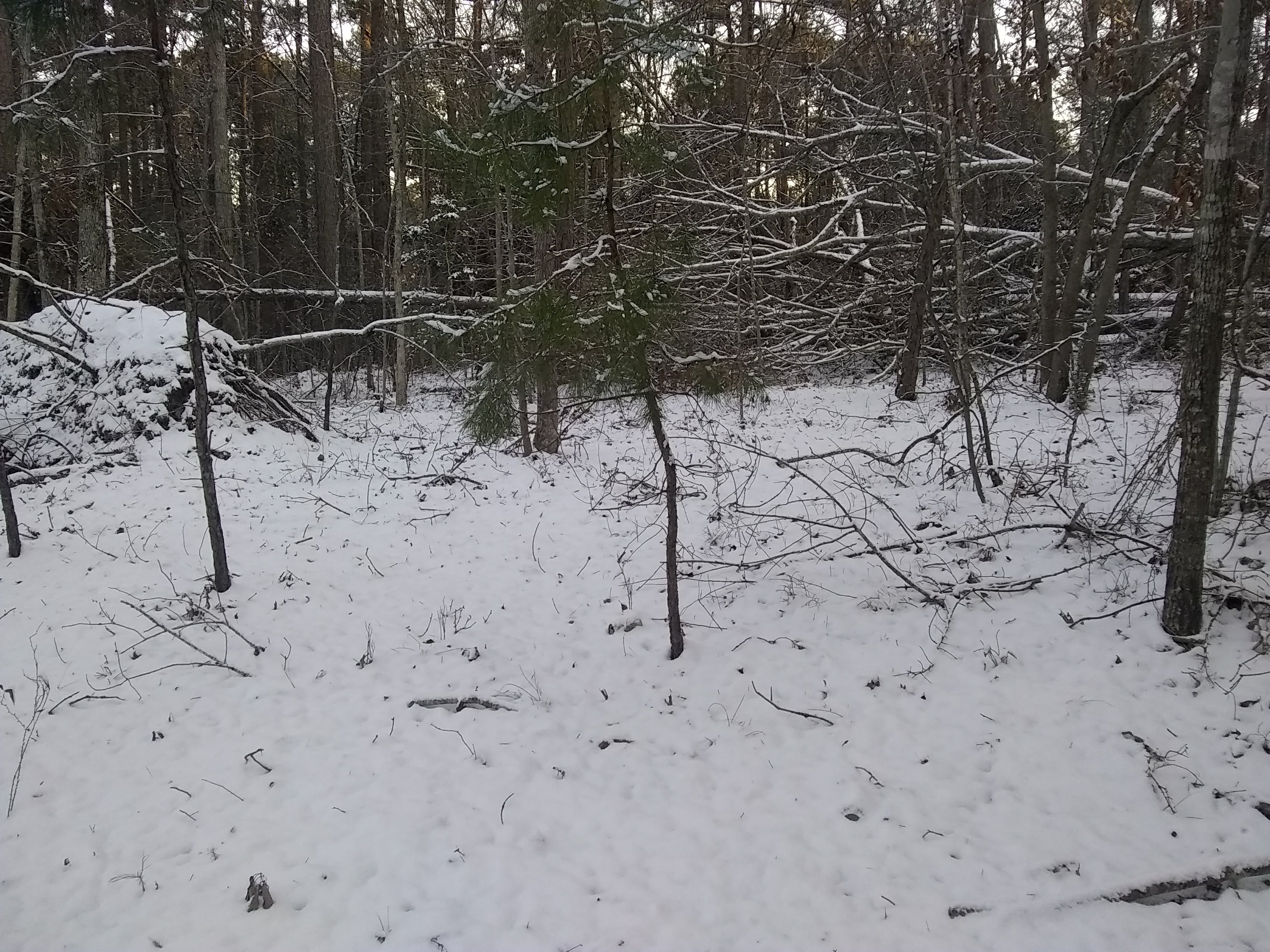
I don't see any snow total posts from Augusta, GA. I am 20 miles north of Augusta and ended up with 2 inches. I tried to find a place to take a picture with no trees down but thanks to being in the eastern eyewall of Helene, I have extensive damage to trees all over my land due to 100+ mph wind gusts.
-
 2
2
-
-
2 hours ago, metalicwx367 said:
Currently 28F with sleet.
After that brief period of heavy snow, we switched back over to sleet. We were pretty much sleet for 90% of the storm. 3 inches of sleet and snow in backyard at the moment.
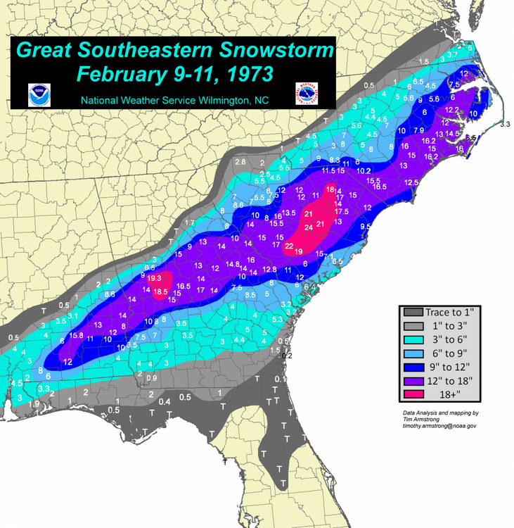
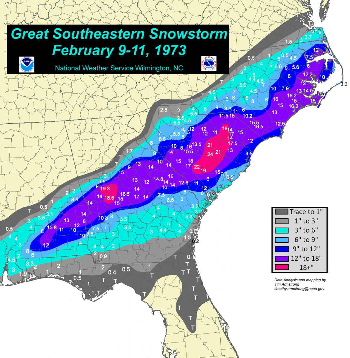
CMC/RGEM were the only models that showed a pure sleetfest here. Still an incredible storm though. I am curious to see what KAYS reports for totals and if we beat the 1973 record.
Here is the accumulation map from 73.
-
It just started snowing here.
-
 1
1
-
-
The FFC in GA has issued a Winter Storm Watch.
Forsyth-Hall-Banks-Jackson-Madison-Paulding-Cobb-North Fulton-
Gwinnett-Barrow-Clarke-Oconee-Oglethorpe-Wilkes-Carroll-Douglas-
South Fulton-DeKalb-Rockdale-Walton-Newton-Morgan-Greene-
Taliaferro-Heard-Coweta-Fayette-Clayton-Spalding-Henry-Butts-
Jasper-Putnam-Hancock-Warren-Troup-Meriwether-Pike-Upson-Lamar-
Monroe-Jones-Baldwin-Washington-Glascock-Jefferson-Harris-Talbot-
Taylor-Crawford-Bibb-Twiggs-Wilkinson-Johnson-Emanuel-Muscogee-
Chattahoochee-Marion-Schley-Macon-Peach-Houston-Bleckley-Laurens-
Treutlen-Stewart-Webster-Sumter-Dooly-Crisp-Pulaski-Wilcox-Dodge-
Telfair-Wheeler-Montgomery-Toombs-
Including the cities of Soperton, Franklin, Hawkinsville,
Columbus, Decatur, Covington, Montezuma, Marietta, Atlanta,
Sparta, Vidalia, Gray, Homer, Monticello, Warrenton, Eatonton,
Ellaville, Talbotton, Toomsboro, Winder, Sandersville, Cumming,
Dublin, Vienna, Alamo, Griffin, Pine Mountain, Greensboro,
GIbson, West Point, Swainsboro, Mcrae, Eastman, Wrightsville,
Athens, Madison, Jackson, Louisville, Newnan, Lawrenceville, Fort
Moore, Fort Valley, Buena Vista, Watkinsville, Monroe,
Crawfordville, Mount Vernon, Preston, Zebulon, Washington, Comer,
East Point, Cochran, Dallas, Gainesville, Jeffersonville,
Stockbridge, Cordele, Milledgeville, Abbeville, Macon, Forsyth,
Douglasville, Lumpkin, Barnesville, Manchester, Americus,
Riverdale, Warner Robins, Crawford, Peachtree City, Commerce,
Conyers, Carrollton, Butler, Thomaston, and Roberts
330 AM EST Sun Jan 19 2025

...WINTER STORM WATCH IN EFFECT FROM TUESDAY MORNING THROUGH
WEDNESDAY MORNING...

* WHAT...Periods of snow that could be moderate to heavy at times.
  Total snow accumulations between 1 and 3 inches possible. Light
  sleet and freezing rain will be possible in portions of east
  central Georgia late Tuesday night. Ice accumulations less then
  0.1 inch possible.

* WHERE...Portions of central, east central, north central,
  northeast, northwest, southeast, and west central Georgia.

* WHEN...From Tuesday morning through Wednesday morning.

* IMPACTS...Plan on slippery road conditions. The hazardous
  conditions could impact the Tuesday evening and Wednesday morning
  commutes.
-
1 hour ago, PackGrad05 said:
Remember that on the NW edge of that shield, ratios will be BETTER than 10:1
When I lived on Beech Mountain back in 2010-2012 we had snow ratios of 40 to 1 to 60 to 1 in some very cold NWFS events. The temp was below 20 degrees to about 5 degrees during these events. The winter of 2010-2011 Beech Mt got 160 plus inches of snow.
-
2
-
-
Getting big flakes. I haven't seen snow here since 2021. Nice.
-
4
-
-
It sleeted here for 2 hours. Then it stopped and now it is starting to snow, no sleet. I am under heavier returns now. I think there must be a higher dry layer that is getting saturated. I am 25 miles north of Augusta, GA.
-
1
-
-
Already light sleet on the border of central GA and northern midlands of SC.
-
I noticed most of us in this thread joined in 2010. Is that when Eastern Weather changed to American Weather?
-
1
-
-
It is starting to freeze rain on Sugar Mountain. The sleet and freezing rain the models have been showing were accurate.
-
They are making snow on Sugar mountain. Shows how dry the air is still. https://www.resortcams.com/webcams/sugar-ski/
-
37 minutes ago, bess said:
Sleeting in Lenoir currently at 46.7
I used to work in Lenoir at Magna. I lived on the back side of Beech Mountain at about 4200 ft. My point is, if you get no snow, it is a short trip to see some. Peace!
. -
I lived on Beech Mountain from 2010 to 2012. We received over 150 inches of snow the winter of 2010-2011. Good luck mountaineers, lol. Peace!
-
3
-
-
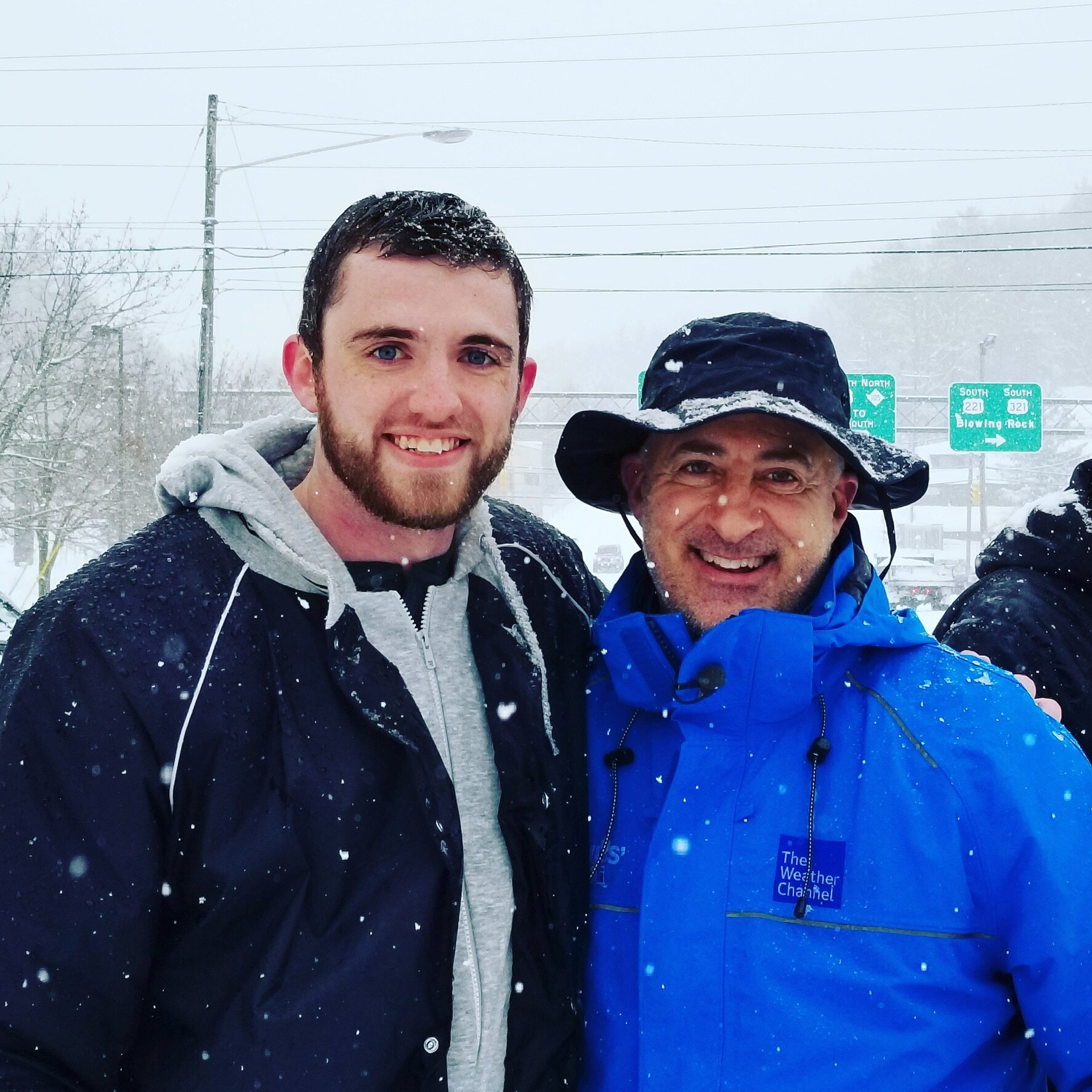
7 minutes ago, AsheCounty48 said:
But I wanted a Dec 2018 redux!

Nice pic. I always liked Jim's passion for the weather!
-
2
-
-
35 minutes ago, WXNewton said:
Through the Catawba Valley this map doesn't even come close to matching the liquid equivalent that most models are showing. His freezing rain map only has .05"-.15" of freezing rain. This would only capture about .5-.75 inches of precip falling to match these totals.
I think it because in his earlier videos he said that it would be heavy precip and that would affect ice accumulation. He said light to moderate precip would result in higher ice totals.
-
1 minute ago, yotaman said:
Boy if these maps verified every time they showed a big snow storm in my neck of the woods. I would have 50" by now. LOL

Yea, I agree. That is why they are called "clown maps". Peace
-
1 minute ago, Orangeburgwx said:
I have nearly been run off this board multiple times by weenieing over 73 to the point I keep my mouth shut about it
Sent from my LGL322DL using Tapatalk
Damn, I was alive when it happened. I am surprised by that. Thanks for the heads up. I have been a member here for 11 years and even when it was Eastern Weather I was a member but I don't post much anyway. Peace!
-
10 minutes ago, Orangeburgwx said:
Yikes

Sent from my LGL322DL using Tapatalk
You live in my neck of the woods. Look at the link to the SE snowstorm of Feb 9-13 1973. You see any similarities? Even the date is close. Anyway I have hope but its to far off but I am amazed at the similarities. https://www.weather.gov/ilm/Feb1973Snow
-
7 minutes ago, Wow said:
here ya go wx weenies

I know this is way out there but it really favors the Southeastern snow storm of 1973. I know this map is almost always wrong but it is interesting. https://www.weather.gov/ilm/Feb1973Snow
-
Snow mixed with rain 30 miles north of Augusta GA.
-
1
-
-
18 minutes ago, CaryWx said:
Is that the ULL center rotating just northwest of Columbia, SC
To me it looks like the ULL center is near Athens, Ga
-
6 minutes ago, DeepSouthSC said:
It's been nearly 4 years since we've had accumulating snow, but it has snowed two or three times since we've last had accumulating snowfall in March of 2017.
I am hoping this is the year that Macon, Augusta, Columbia gets a Miller A scenario and gets a good snow. It has been about 10 years since the fall line got a good snow.
-
On 2/9/2020 at 9:28 AM, buckeyefan1 said:
Living in Columbia for 20+ years, I understand your frustration. I can’t tell you how many winters I couldn’t buy a single snowflake, while everyone else cashed in. Often multiple times during the season, lasting several years in a row. At least you’ve seen flakes in a horrible year across the eastern half of the country. That’s more than some can say. Just add it to your bucket list of things you wouldn’t want to repeat
 That’s what I do. This way I have “I survived” stories to tell the next generation
I understand 100%. I have moved back to where I grew up in the Augusta Ga area on Clarks Hill Lake and it is rough down here most of the time but in 1973 when I was 4 years old it snowed 16 inches here. I don't know if you were alive then or lived in Columbia then but talking with my Grand Father when he was alive and my Great Grandmother she remembered a heavy snow in the late 1880's and my Grand Father remembered a heavy snow when he was about 10 years old in the early 1910's both over 10 inches and then the 1973 snow. They lived to see both. I am 50 so I have seen one and I am gonna follow family tradition and live to see my second heavy snow, lol. These are rare but put down higher totals than most of the state! Here is a link to the NWS account of the 1973 storm..... https://www.weather.gov/ilm/Feb1973Snow
Ran across this... https://www.weather.gov/cae/Snowfall_Total_Records_cor.html
-
I have not seen this posted. GA NWS video...
-
1
-
1/21-1/22 Winter Storm OBS Thread
in Southeastern States
Posted