
Tropopause_Fold
-
Posts
13,538 -
Joined
-
Last visited
Content Type
Profiles
Blogs
Forums
American Weather
Media Demo
Store
Gallery
Posts posted by Tropopause_Fold
-
-
That sounds like a real doozy.
haha this actually made me

-
Climate sensitivity (warming per doubling of Co2 concentration) is probably the best way to break down peoples opinions into categories. Since you've all used loaded language in you labels, I'll continue with the tradition:
1. Extreme alarmist: believes or focuses solely on the high end or even higher than the scientifically accepted climate sensitivity (>4C). Focuses solely on the worst case consequences and denies or ignores all benefits.
2. Alarmist: believes or focuses on the high end of scientifically accepted climate sensitivity (3-4.5C). Focuses usually on the worst case consequences and acknowledges few of the benefits.
3. Scientifically grounded: acknowledges the full range of scientifically accepted climate sensitivity (1.5-4.5C). May lean slightly one direction or another within that range based on a good-faith effort to objectively interpret the evidence with assistance of peer-reviewed literature, but acknowledges all of the uncertainty and the lack of concrete evidence. Has a balanced understanding and acceptance of the various consequences and benefits and the evidence that on net the consequences will be negative. A moderate to high level of mitigation is warranted, and adaptation cannot be relied upon solely.
4. The biased/arrogant/confused/misled lukewarmer category: believes or focuses solely on the low end or slightly below scientifically accepted climate sensitivity (1-2C). Ignores the evidence that climate sensitivity is probably higher than 2C. Often an undue focus on the benefits of AGW, or downplaying of the consequences. Possibly believes that the benefits of AGW will outweigh the consequences.
5. Denier/stupid: believes in a climate sensitivity below the scientifically accepted range (0-1.5C). Usually focuses on the benefits of warming and downplays the consequences. Probably believes that the benefits of warming will outweigh the consequences.
6. Extreme denier/stupid: believes CO2 has little to no warming effect. If warming did occur, it would be good.
in the context of this forum...the above may hold some water. but outside of the 20 or so posters who frequent this sub-section of AmericanWx...the above categorization is ridiculous.
-
once you realize he's still alive...it's pretty good.
-
actually thought part of that was serious for the first couple of lines.
-
I miss turning on the flood lights watching the kids sled, walking out on the deck listening to the powder crunch under foot, taking deep breaths of arctic air, hopefully those times are around the corner.
this^^^
agree heavily.
-
It was also a mix most of the day in the south shore. It pretty much was snow, but it did mix when it was very light and the snow came in waves, which as you know...usually happens when it's borderline ra/sn. Nothing really stuck until 7ish.
yeah the day of the 26th was one of those funky meteorology days along the coast. there was a nasty coastal front. i remember it was in the upper 30s with sprinkles/flurries down here most of the day while places inland were shivering and getting some OES to boot with onshore flow.
-
I remember seeing the radar really early that morning (maybe like 4am or something) and there was like a black band rotting over the Cape and I was so jealous, lol. You could see the stars by that point here.
yeah i lived in harwich at the time...which proved good in the end...but was frustrating for the first half of that storm. just a few miles west, hya was over to S/S+ much earlier, but the heaviest stuff ended up right over the inside elbow overnight.
-
I happened to find this site the other day. Anyways, it has cool pics from the Cape snow bomb of 12/26/-12/27 2004. It looks like some family pics...but oh well.
LOL - it's a liitle creepy seeing those people up close, but otherwise those are good pics. i recognize a lot of those areas. actually, will and i were standing in a few of those spots during Irene. lol.
one of the more impressive aspects of that storm is basically 16-18" fell in about 6 to 8 hours. it started as a rain/snow mix in the evening and took forever to actually flip and start to accumulate. it wasn't until 9 or 10PM that things really started to get going...i remember being really pissed, and really worried, at around 8:30 or so because it was basically liquid snow falling...just slush. but then around 9 or so it started to go to town and just went nuts for the next 8 hours...it was all done by first thing in the morning....couldn't open the front door.
-
We are potentially only 3 months away from our first flakes. We saw that T-2" snowfall on October 16, 2009...then another on October 18, 2009. This thread gets me pumped up for tracking winter events again.
Yeaah...let's just squeeze a strong TS or better into the area first...need to have a better chase night. This time with goggles so we can read the handheld anemometer....then bring on the cold and snow
-
Scott and I were discussing how you musn't just consider the track, but also the scale of the mid level features and many of last season's systems were compact and energetic.
oh yeah no doubt. And I think some of the events even ended up stronger and more dynamic than modeled.
-
We lost snow in the open areas by mid March but the woods held onto snow pack until mid April. But if you were doing it by "official" guidelines, then we were down to nothing by mid-March. Those two huge torching rainstorms killed us. I still had over 20" on March 1st.
obviously it goes hand-in-hand with the totals, but that's another memorable aspect of last winter - just the pure longevity of the snowpack. even down here where things dropped off so much earlier in the season the frequency of events was enough to overcome the crap-factor and keep snow around for what felt like the whole winter...be it in piles or wooded areas.
-

when did you "officially" have bare ground in the spring?
-
I just right click on the image and "save image as". It saves it as an animation..I don't have to do anything.
huh. good to know. never tried that.
-
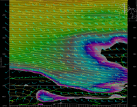
I thought this grab was really cool. It's the coastal front diving southeast on 1/12. This is the image that makes Ray cry and myself just delighted.
Check out how the southwestern end was moving to the east much quicker than the area up by Newburyport. The low was pulling to the ene, so it makes sense.

that's a great image.
how do you save the animation? do you create an animated gif manually or does weathertap provide that?
-
That got borderline creepy/scary.
i locked my doors. lol.
-
his once-in-a-lifetime winter.
-
Yeah and he didn't get the good surprise either than Phil got on Jan 8th. The one where he had like a trace and Phil had 5"+.
Than 10 miles NW everyone got 2-3". you mean the one where he drove from plymouth to wellfleet stopping at every exit and rest area, measuring, taking a photo and then continuing on??
 -
LOL, I think Messenger probably got blue-balled the worst, considering about 15 miles nw of him got hit hard.
I'm humble because I had almost no business getting the snow I got, considering the storm track on some of these. No bragging here, because the next one could easily turn into a nude game of twister for Ray, while I'm listening to raindrops bouncing off my windows.
yeah there were tracks where jerry was talking about NAM clown maps giving BOS 12 to 16 or whatnot and i was thinking - no way...not with a canal cutter. but sure as sh*t the clown maps would verify. LOL.
-
Eventually we'll have another '04-05 where Phil's snow pack is twice that of Kevin's like it was that winter.
as long as there are some good events, i'm usually content - i just don't want to get a complete region-wide clunker accompanied by 50s in january.
-
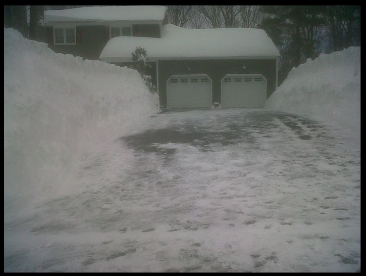
We gotta get you a good one for this winter. You were a good sport during this winter. Obviously you're happy to get good storms and you did get nailed by the 12/20 storm, but I'm sure the posts of Kevin's snowbanks while it was raining were a little disappointing.
funny i was just looking at that picture yesterday. he emailed it to me back in the winter and i threw it up on FB. those pictures were ridiculous.
-
Here's the mid level middle finger for parts of central ma into CT.
what an emotional clusterf*ck that storm was. LOL
-
yeah that was a true testament to weenie-ism. i was in the hospital...my son was being born...and i'm looking at model runs on my phone that are reverting back to a good cape-scraper.
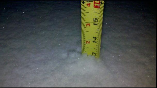
10.5" IMBY - but just missed the 13/14 that fell in harwich/orleans area
-

yeah that was a true testament to weenie-ism. i was in the hospital...my son was being born...and i'm looking at model runs on my phone that are reverting back to a good cape-scraper.
10.5" IMBY - but just missed the 13/14 that fell in harwich/orleans area
-
 1
1
-
-
 s
s
New England snowstorm memories.
in New England
Posted
so...do you live on the Cape?