

weathertree4u2
-
Posts
92 -
Joined
-
Last visited
Content Type
Profiles
Blogs
Forums
American Weather
Media Demo
Store
Gallery
Posts posted by weathertree4u2
-
-
10 minutes ago, Carvers Gap said:
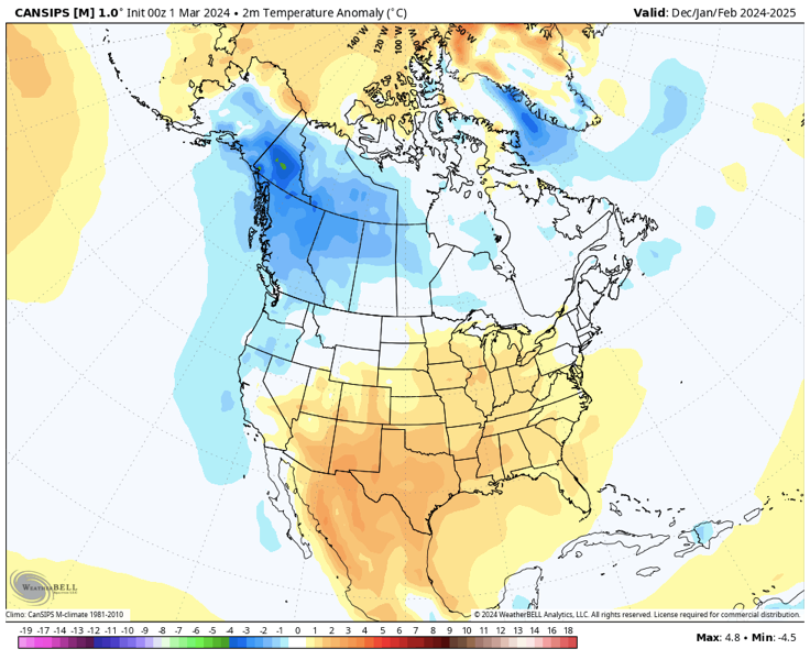
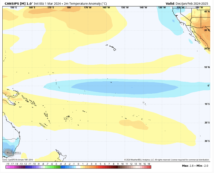
New CANSIPS is out. Here is the look for next winter. @Itryatgolf70, I have also attached the predicted seasonal DJF surface temp map for the Pac basin. Starts east based in Sept and migrates to central basin by December. Huge grains of salt as LR modeling almost always has a very warm bias. So, TIFWIW. Monster SER and Aleutians high are the staple features. The model really doesn't show a typical Nina progression for next fall/winter, but....I would guess some analogs are non-winters. The danger w/ stronger ENSO events is that winter never shows up, and we have been long overdue for a non west of the Apps. May need a whole heard of elk next winter. The Mountain West is set for a great winter next winter. -PDO features prominently. I would guess the compiled, overall DJF look is correct, but the progression of how it arrived there...not right. That progression is critical for how our winter looks here.
Summer starts cool and ends hot...but that really isn't earth shattering stuff, right? I need to go back and look at precip.
With such a huge miss by long range modeling this winter, what is it about the model that would illicit any confidence? At this point, I dont trust anything outside 24 hours but I dont have as much experience at some reviewing long-range guidance
-
 4
4
-
-
4 hours ago, Matthew70 said:
Well I say, winter is now over with except for a couple of cold spells and the normal blackberry Dogwood winters. Hopefully we don’t have a killing freeze. Except for one week in January this winter was a complete sham..
Yea, pretty similar to the last several but hey, did have that week in January!
-
2
-
-
7 hours ago, jaxjagman said:
Take that back,we moved to Lawrenceburg a couple years after the F5 hit Lawerenceburg a couple people took me on a tour where the tornado path went through there,think we moved to Nashville in 2010,not really positive on the exact dates but i dont remember it getting that cold
I recall that in 2007. Things were almost fully leafed out, like two days after, all the leaves were brown and dropped. Some trees lost about two weeks of growth as they didn't leaf out again overnight of course. Seems like it was upper teens here where I am north of Nashville
-
1
-
-
5 minutes ago, PowellVolz said:
Winter definitely doesn’t last long anymore
.Yea, I shudder to think what would happen to the forum area if we had a winter like we had when we were kids in the 1970's
-
3
-
-
26 minutes ago, PowellVolz said:
3 of the last 4 winters in MBY I’ve had at least one 6” snow and two 7-9” snow. Not at all going to complain.
.Yea, technically, I have done well also north of Nashville the last two seasons, however, I would have liked to have had a longer "winter" season that just the week we had in January this year but technically both seasons I have had above the seasonal average in snowfall
-
2
-
-
Not really seeing anything promising in the long range - probably just my untrained eye, but what do those with more experience think Spring/Summer will hold for the area - the forum area; looks like Bastardi is predicting higher than normal hurricane activity in the Atlantic this year.
-
1
-
-
38 minutes ago, jaxjagman said:
BY the GFS winter returns in East Asia,not to the degree the other models shows,but they still show it.
.thumb.png.1c0c3e8c5bd3f8434870018a6be91c7e.png)
Does that impact the lower 48?
-
4 hours ago, *Flash* said:
Yeah, it was fun while it lasted. Wish I could have heard that thundersnow given it occurred on the west side of town.
Funny how all of the snow was south and west of town while at one time the only winter advisories were for north of town
-
9 minutes ago, Holston_River_Rambler said:
Winter.
Weather.
Advisories.
Middle TN.
I think it is amazing how this one seemingly came out of no where in just the last 36 hours
-
2
-
-
8 minutes ago, Silas Lang said:
Annnddd the 18z looking totally different. lol
And that is a surprise? OMG
-
1
-
 1
1
-
-
22 minutes ago, *Flash* said:
Kinda curious how the pattern flip could bust after great consistency from the Euro Weeklies. I haven’t checked them out in several days but I imagine they’ll adjust at some point?
Yea, it's like the Titans, always some obscure little considered reasons for failure. I am real close to being on team spring at this point.
-
2
-
 1
1
-
-
39 minutes ago, Daniel Boone said:
Suppression is more the worry for us in the upper South. However, if a similar setup occurs like strong blocking year's, ala., 1960 the entire area should do well by the time all is said and done. Of course, there was 1973. Deep SE Monster while our area received 1-3" deals.
Well, all in all, not really any need of looking at the finer details this far out
-
1
-
-
GFS was an epic run for NC!
-
3
-
-
Just now, Carvers Gap said:
I think this is going to come in waves. Spring will fight back in between cold shots....but good looking pattern coming together. As long as we have the Pacific, I think we are good.
Could lead to a active severe weather season on into Spring
-
1 minute ago, Carvers Gap said:
The 12z CMC is just ridiculously cold.
that looks to be another shot of cold air building in Canada on the GFS
-
2
-
-
Just now, Carvers Gap said:
What went poof? Not following.
Went poof, compared to the overnight run, it went poof for middle TN any way, depends where one is located I suppose
-
1
-
1
-
-
2 minutes ago, Carvers Gap said:
12z GFS is set to bring the mother load on this run.
Seems like it went poof for some reason - good news is that the storm signal in that time frame remains - details this far out are going to be murky
-
2 hours ago, John1122 said:
From 264-270 that run, 8 inches of snow falls imby. Not to be outdone, from 270-276 12 inches falls. The wild thing, temps that follow it are similar to what we had in January, highs in the upper 10s and lower 20s and lows between -3 and 10ish are widespread.
I'd love to see such an event come to pass, in 1960 the first big storm in February was a brute with similar totals.
February and March 1960 had a few good size snowfalls in middle TN
-
1
-
-
What is the issue with the GFS retaining all the moisture around the gulf but never really meeting any of the colder air. Is there a reason why?
-
5 hours ago, Matthew70 said:9 hours ago, PowellVolz said:
What kind of shrubs?
Nandinas again.They should come back out in spring
-
2
-
-
11 minutes ago, Carvers Gap said:
Below are the lead analogs to the extended maps. I "think the time to watch will be Feb20-28 and possible beyond.
Day 8-14 CPC analogs
19680210
19780222
19840302
19770204
19680228
19800210
20050302
19700211
19580217
19950205
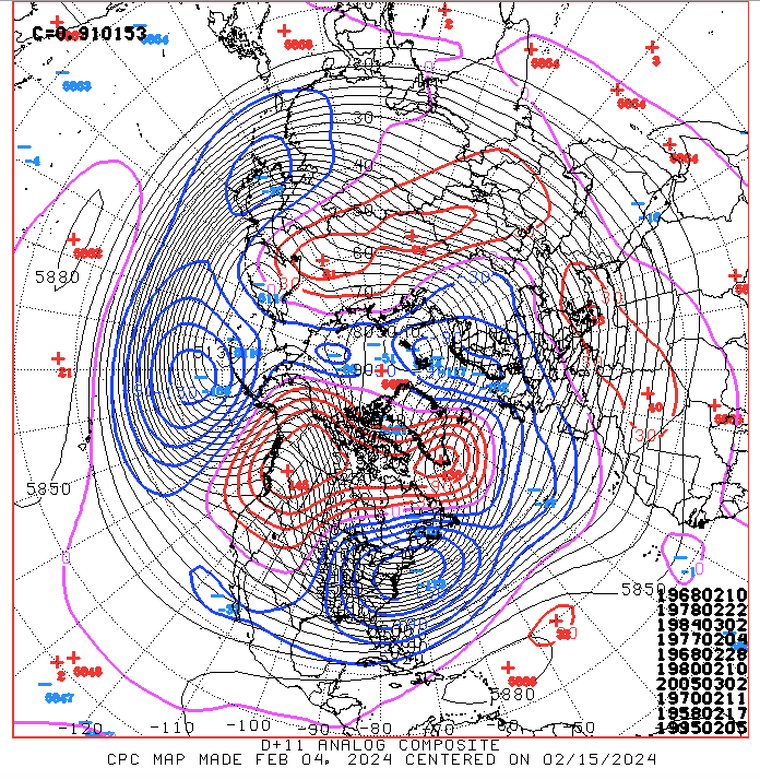
March 1970 saw a 9" snowfall in Middle TN
-
1
-
-
Hopefully the pattern can turn wetter as we head into Spring.
-
3
-
-
11 minutes ago, tnweathernut said:
Not trying to be a wet blanket, but does anyone remember the year where there was almost complete agreement we were headed toward a great pattern. Almost all ensembles were pointing toward it, and I think we were fringe OP range. Then, a SSW occurred and modeling did a 180. I don't remember the year, but I remember having a very different view of SSW's the year that happened.
Yea, was not that long ago doesnt seem like it
-
my bigger concern is that we seem to be back into the pattern of a few days of rain then two weeks without rain. Any ideas when it might be different? Anybody?
.png.e4e5522e1aec8d88172dbac7d83befa1.png)
March/ Spring mid-long range
in Tennessee Valley
Posted
Probably low 20's where I am north of Nashville not good things are putting out