

Thinksnow22
-
Posts
7 -
Joined
-
Last visited
Content Type
Profiles
Blogs
Forums
American Weather
Media Demo
Store
Gallery
Posts posted by Thinksnow22
-
-
-
12 hours ago, Ruin said:
I have before. The philly game was about 18 inchs during the game the pats game had a good 2 feet vs oakland. I remember a lake effect game during the bills playoffs of the 90s as well. it feels that tho if your going to stop a game form being played in lake effect snow for safety reasons. you should postpone a game that has single digits as well as -15-25 windchills. did you see Patty's helmet break from,a hit? most likely broke cause of how cold it was.
The pats did not have 2 feet during the Oakland game. There was 4-5” during the game. The snow is currently falling at 3-5” an hour over the stadium as we speak.
-
1 hour ago, BuffaloWeather said:
I agree with this. I think the only hypothesis that could be made based on AGW are the constant thaws after nearly every event. In a "normal" winter lake Erie is frozen by the 2nd/3rd week of January. The last 10 years or so we're seeing the lake effect season last well into February. We saw 2 examples of that already this year. 80" in the November event and then a massive thaw and again with this event we are going to see 10 days of 40+ degrees. This results in Lake Eries lake effect potential lasting far longer than in past years. KBUF is going to have an above average Nov/Dec in terms of temperature, and they already had 100"+ of snow. That statistic is absolutely insane....
What’s interesting with AGW would be the average snowfall totals have risen at KBUF in the last 30 years, but more so recently. I remember as a kid in the ‘80’s and ‘90’s the average snowfall was 93.2 and has since risen to 95.6” average. I don’t believe this is coincidental as BW has alluded to that we now have a longer lake effect season and the weather pattern has changed so we’re seeing more storms cut to our west leaving the area with more SW wind events than there are NW wind events which is why planes like Rochester and Syracuse are seeing fractions of their annual snowfall as they did when clipper systems were more prevalent
-
 2
2
-
-
IF we can get anything near what the OP GFS is showing at the end of its run (yes pure fantasy land) then I would be ecstatic. That low retrograding into or just south of Hudson Bay would open up some serious lake effect opportunities during a good portion of that stretch
-
1
-
-
5 hours ago, BuffaloWeather said:
Updated FD:
.LONG TERM /THURSDAY NIGHT THROUGH MONDAY/...
...IMPACTFUL LAKE EFFECT SNOW STORM POSSIBLE THIS PERIOD...

No change in available model output and overall H85 and H5 pattern
for late this week into the weekend. There remains high confidence
that a prolonged southwest flow lake effect event will take place
during this period. A deep longwave trough...featuring a vertically
stacked low in the vicinity of Hudson Bay...will keep a flow of
seasonably cold air in place over the Lower Great Lakes through the
weekend to GUARANTEE a lake response. The `formula` for significant
lake snow will then come down to whether there is ample synoptic
moisture to work with...and of course the direction of the H85
steering flow. Consensus of both ensemble and deterministic guidance
packages are in fairly strong agreement of a southwest flow...but
placement of accumulating snow bands will have to be further defined
as the event nears. Continues to look like KBUF and KART metro areas
and their northern suburbs (at least for a time) are favored.

This event has some historical precedence, with CIPS analogs
comparing to Nov 20, 2000, when many became stranded in their
vehicles...or the twin storms that made `Snow-vember` infamous with
over five feet of snow? While at this point it is impossible to
suggest the same for the upcoming event...it is something to keep in
mind. Speaking of correlations...local studies from the KBUF office
does show some stark similarities in the synoptic pattern for these
larger events. The largest events have near stationary plumes of
snow...but it is still way too early to get that detailed.

In the wake of a passing shortwave ridge on Thursday...subtle
troughing embedded within in the larger scale longwave pattern will
produce a deep southwest flow of cold air across Lakes Erie and
Ontario. There is a suggestion that the flow will generally be 250-
260 Thursday evening...but with the lakes still relatively warm (nr
of abv 10c)...that flow could back some 10 deg over Lake Erie.
During the course of Thursday night and Friday...the flow is
forecast to back a bit...and this will send well organized lake snow
plumes across the Buffalo and Watertown metro areas and potentially
into the northern suburbs. Again, placement of these bands will
depend on the exact H85 flow...but a southwest (240-250) flow is
being favored by guidance at this time. Given the expected presence
of moisture up to arnd H7...snowfall rates of 1-2"/hr is becoming
more plausible. Details still have to be refined, but there was
enough signal and consistency in model guidance to issue winter
storm watches Thursday evening through Sunday evening for a
potential high impact, long duration lake snow event. If winds back
further for longer period of time, then Niagara and Orleans counties
would need to be put in a watch as well. Those details can be sorted
out next couple days though.

While the steering flow will likely oscillate somewhat during the
course of the weekend and into early next week...a cold southwest
flow is mainly what is being shown by most of the guidance packages.
This would keep lake snows in place to the northeast of both lakes
with additional significant accumulations possible at times even
beyond when initial watch ends.
240-250 is dead center metro-airport. I do like how they mention that subtle 10 degree or so shift due to the warm lake waters making it a more 230-240. I think at them end of it all many places end up 18-24” with a jackpot of 40” plus somewhere between Airport and Blasdell
-
Finally!!! I have been granted access again from my long overdue absence!!! Just in time as the models are going bonkers this weekend!
Lake Effect Event-Buffalo Bills Playoff Game Impacts
in Upstate New York/Pennsylvania
Posted
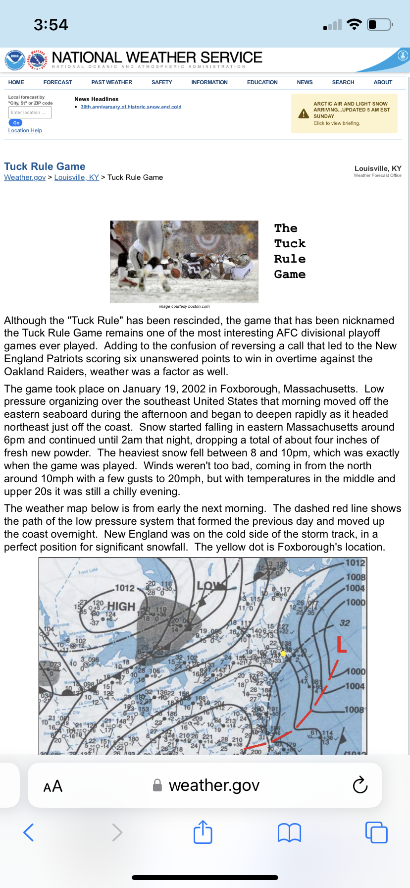
Right from the NWS site