

Lucketts Life
-
Posts
74 -
Joined
-
Last visited
Content Type
Profiles
Blogs
Forums
American Weather
Media Demo
Store
Gallery
Posts posted by Lucketts Life
-
-
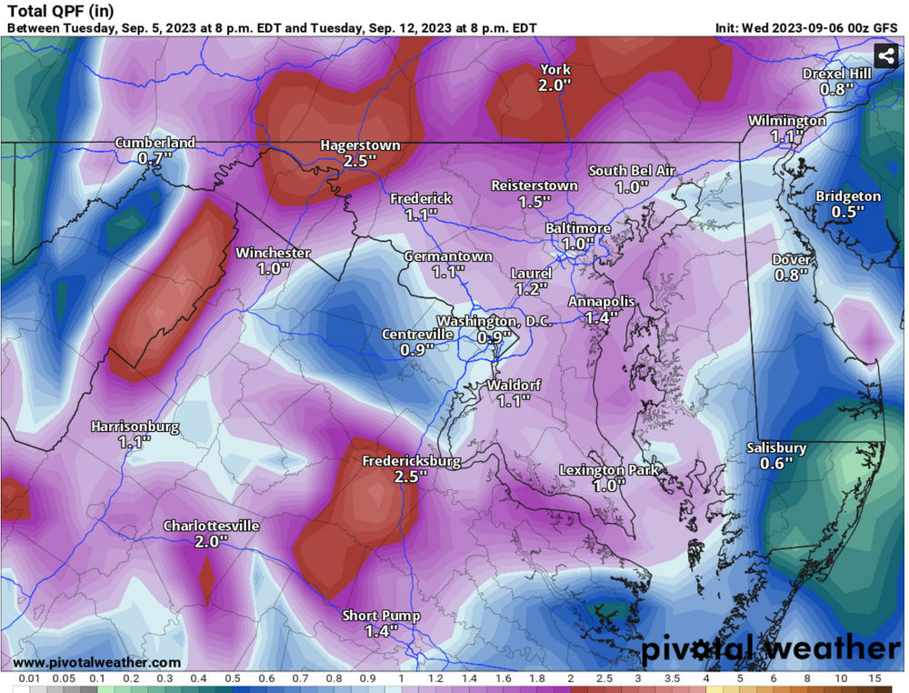
50 with heaviest rain of the day.
-
47 minutes ago, Weather Will said:
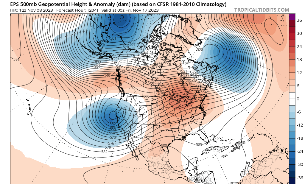
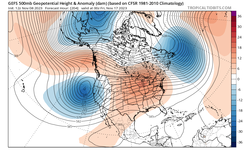
WB 18Z GFS.....Storm 1, 2, 3.... signs of Nino....welcome rains hopefully on the way the next 2 weeks.


This would be quite the drought buster for this area. I would be ecstatic if 50% of that fell.
-
1 hour ago, WxUSAF said:
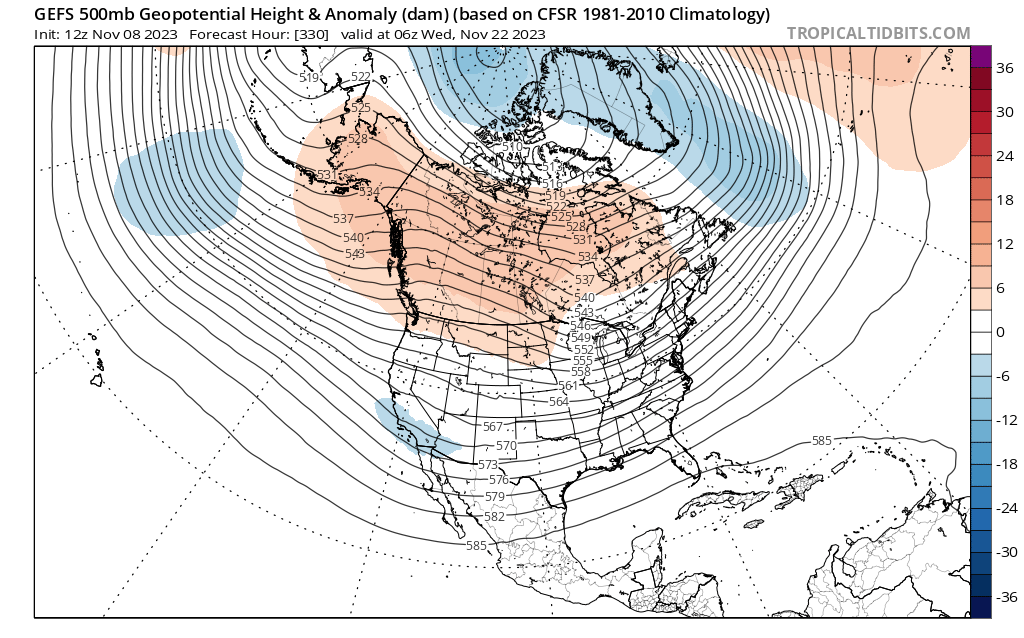
Pretty good ensemble agreement on how the pattern develops going into Thanksgiving week with a much more Nino-like look to things. Pattern shuffle starts with this big upper low crashing into the west coast around D8-9.
That serves to undercut the ridge in Canada and ridging expands over AK. This doesn't look like a particularly cold pattern for us with a +AO/+NAO and the coldest air from the -EPO will dump out west first before coming east. But it looks a lot more Nino-like and actually looks a fair bit like the December seasonal forecasts.
Should also get us some regular precipitation started again...
This would be welcome. Could really use that precip.
-
 1
1
-
-
68° perfection!

-
5
-
-
Happy for O's fans! Exciting young talented team with plenty more coming from the farm.
-
2
-
-
This afternoon has been nothing short of spectacular. Currently 72 with plenty of sunshine.
-
1
-
-
8 hours ago, Chris78 said:
Bull pen is taxed.
8 runs should be enough to win.
Missing Bautista badly.
Cano is not a closer
100% on the pen being taxed. Cano is out of his role. This is a solid team but that pen needs some relief and I don't know where it comes from.
I hope they don't rush Bautista back but you can see they're toying with the idea.
-
2 rounds of quick hitting thunderstorms over the last 2 hours. Violent lightning strikes with each storm. The heat is gone! 75°
-
1
-
-
14 hours ago, midatlanticweather said:
Sheesh! What is wrong with Loudoun County?!
Seems to be the theme for this summer up around Point Of Rocks on the VA side.
Fingers crossed that we get more than that.
-
2 hours ago, Eskimo Joe said:
I don't think people realize how lucky we are to be average temps with a 597dm ridge over us. We're dodging freight trains here weather wise this year.
Currently 80° with 37% humidity and a breeze. Unreal in the best possible way!
-
1
-
-
10 minutes ago, yoda said:
BULLETIN - EAS ACTIVATION REQUESTED
Severe Thunderstorm Warning
National Weather Service Baltimore MD/Washington DC
438 PM EDT Mon Aug 7 2023

The National Weather Service in Sterling Virginia has issued a

* Severe Thunderstorm Warning for...
  Southeastern Carroll County in north central Maryland...
  Northwestern Howard County in central Maryland...
  Northern Montgomery County in central Maryland...
  Southeastern Frederick County in north central Maryland...
  West central Baltimore County in northern Maryland...

* Until 515 PM EDT.

* At 437 PM EDT, severe thunderstorms were located along a line
  extending from near Walkersville to near Linganore-Bartonsville to
  near Point Of Rocks, moving east at 55 mph.

  THESE ARE DESTRUCTIVE STORMS FOR SOUTHERN FREDERICK COUNTY,
NORTHERN MONTGOMERY COUNTY, WESTERN HOWARD COUNTY, AND SOUTHERN
CARROLL COUNTY IN CENTRAL MD.

  HAZARD...80 mph wind gusts.

  SOURCE...Radar indicated.

  IMPACT...Expect considerable damage to trees and power lines. Your
           life is at significant risk if outdoors. In addition to
           some trees falling into homes, wind damage is possible to
           roofs, sheds, open garages, and mobile homes.

* Locations impacted include...
  Germantown, Frederick, Gaithersburg, Olney, Damascus, Harry Grove
  Stadium, Ellicott City, Aspen Hill, Randallstown, Montgomery
  Village, Owings Mills, Eldersburg, Ballenger Creek, Redland, Mount
  Airy, Walkersville, Sykesville, Oakland, New Market and Green
  Valley.

PRECAUTIONARY/PREPAREDNESS ACTIONS...

For your protection move to an interior room on the lowest floor of a
building.

This is an EXTREMELY DANGEROUS SITUATION with tornado like wind
speeds expected. Mobile homes and high profile vehicles are
especially susceptible to winds of this magnitude and may be
overturned. For your protection move to an interior room on the
lowest floor of a building. These storms have the potential to cause
serious injury and significant property damage.

A Tornado Watch remains in effect until 900 PM EDT for northern,
central and north central Maryland.
2 miles from Point of Rocks here (south). Initial winds but nothing severe. Rain was moderate but is now heavy. Winds have subsided with no thunder or lightning as of yet.
-
No precip overnight here in Leesburg area. Hopefully we can cash in today. Looks like areas east of here have a better shot.
-
Hallelujah! Finally got some rain. Coming down for an hour now. Heavy at times and a good soaker for sure. Occasional lightning/thunder but nothing severe as of yet.
-
1
-
-
Just south of Point Of Rocks and we received well over an inch. Multiple downpours, thunder/lightning over a 2 hour period.
-
3
-
-
37° with a few pings of graupel.
-
Is there a preferred model when we're this close to an event?
-
34/27
-
34/34 light drizzle.
-
3 hours ago, Ji said:
every model run feels like an Adam Dunn at Bat...strike out after strike out after strike out
But you could always count on the home run happening before too long. This winter would be the equivalent of Dunn going 0/44.
-
8 minutes ago, CAPE said:
It is looking decidedly more winter-like for next week, with colder air pressing southeastward and placing the thermal boundary clearly in a more favorable position for the first time since probably late December. We have tracked this period for many days and it is now on the doorstep. My expectations were not for some super juiced up wave with a foot+ of snow, but rather a few chances at light to moderate events- we normally need a few shots in any favorable window to hit on one. Signal has been there on the means, and the op runs are now in a range where we can get a better idea on the specifics of how this will evolve. A warning level snow event looks possible next week somewhere in the MA. Hopefully we see a flush hit right across our region.
Nice to be in the game again.
-
1
-
-
1 hour ago, GATECH said:
Yeah there is….70’s. Daffodils are popping in my yard, earliest I can recall.
Natures long range forecast model.
-
1
-
-
32/32 with freezing rain.
We've been going back and forth between sleet, snow, rain and freezing rain for several hours now. Roads are icy in spots.
-
1
-
-
-
5 hours ago, H2O said:
VDOT already beet juice spraying. WTF
White dust clouds everywhere today.
-
1
-


November Discobs 2023
in Mid Atlantic
Posted
25. Peaceful and still.