

Jesse from KY
-
Posts
30 -
Joined
-
Last visited
Content Type
Profiles
Blogs
Forums
American Weather
Media Demo
Store
Gallery
Posts posted by Jesse from KY
-
-
It is currently 2 above in Bell County. KY Mesonet is showing Barbourville (Knox County) at NEGATIVE 2.4F.
-
 2
2
-
-
I am happy to say that it just started snowing at my location in Bell County. Temp is 27F
-
9
-
-
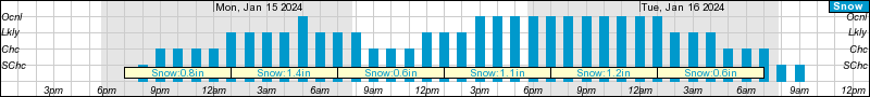
Well, I'd say they will certainly be issuing one now. My point's hourly weather graph has increased totals to 5.7"
30 minutes ago, Daniel Boone said:It's really puzzling they haven't. It's as if they've not looked at the Model's since the GFS showed the lower totals there. The NBM has heaviest there. Could be understaffed today or subs filling in . Alot if sickness going around.
-
3
-
-
Just now, ShawnEastTN said:1 minute ago, Jesse from KY said:I am just curious if NWS Jackson will upgrade some of the TN/VA border counties to a Warning.
Probably if it begins over producing they will. Very possible those border counties in KY might over perform.
It sure wouldn't hurt my feelings if we overperformed! Lol.
-
3
-
-
1 minute ago, PowellVolz said:
Soak it up fellas

.I am just curious if NWS Jackson will upgrade some of the TN/VA border counties to a Warning.
-
3
-
-
1 minute ago, John1122 said:
According to how far north you live, looks like you're probably good for 1 to 4+ inches. But the story isn't written yet, I don't believe. There's gonna be someone close to an edge north and south that sees snow a few miles away but doesn't get much.
Thank you. By the way and for what it's worth, I live in Bell County (on the northern tip).
-
Thoughts on WFO Jackson's discussion this afternoon? It appears they aren't too excited about the potential for Eastern Kentucky? I hope their thinking changes. I soo want a good snow for SE KY
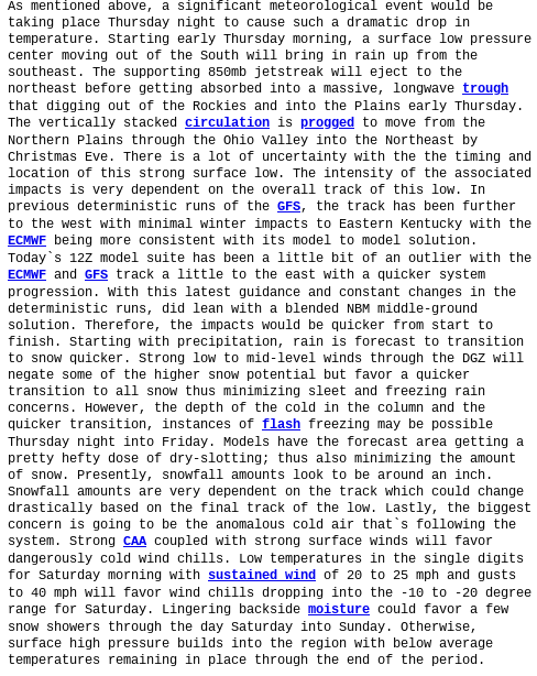
Key Messages:

* An arctic airmass will be in place at the start the work week,
  with daily highs from Monday through Wednesday expected to
  remain at or below freezing. Tuesday morning will drop close to
  zero, or possibly below zero depending on our snow cover.
  Temperatures will moderate above freezing on Thursday before a
  second, reinforcing round of arctic air arrives at the end of
  the period.

* There is a chance for accumulating snow Monday through Tuesday
  and possibly again later in the week. At this time confidence
  remains low on exact amounts. Areas generally south of the
  Mountain Parkway and Highway 80 appear to have the best
  opportunity of seeing accumulating snow. However, overall
  trends have taken snowfall accumulations further south and
  towards lower amounts.

Analysis and Discussion:

Our pattern remains active and highly amplified, with a Hudson
Bay low drifting slowly southward to the Great Lakes Region by the
end of the extended portion of the forecast. This will keep a
mean trough and unseasonably cold air in place across the eastern
CONUS. Relatively weak mid/upper level disturbances will round the
base of the mean trough with eastern Kentucky just within the
corridor of influence of these series of disturbances.

The first of these features within the extended period will
transit the Commonwealth Monday through Tuesday. Precipitation
will develop across the area as a result of weak isentropic lift.
Surface features with this first disturbance are not even
recognizable, providing insight into just how weak this system
will be. At this time there appears to be enough energy to
generate a swath of light snow with eastern Kentucky on the
northern fringes of this systems influence. Trends in run to run
solutions have taken snowfall accumulations further south and
towards lower amounts overall. At present, ensemble probabilistic
snowfall amounts suggest a high probability (> 70%) of an inch or
more along and southeast of a Monticello-Jackson- Paintsville line
with the first system. Probabilities drop rapidly for higher
amounts, with average probabilities of 3 inches or more generally
below 50%, with highest probabilities in along the KY/VA state
line.

The second system basically impacts eastern Kentucky Thursday
night through Friday night. This second system is quite similar to
the first, but appears a little stronger with some weak surface
features appearing in the solutions. As is typical, the only sure
bet is that things will change with time, and it remains to be
seen exactly how much winter precipitation is produced with the
second disturbance, if any.

These are weak systems, which make it a bigger challenge when
trying to forecast detailed sensible weather. However, we can
take some confidence that in general, we are in a pattern that
favors the opportunity of wintry weather, with our forecast area
in the northern, colder sections of these transient disturbances.
Thus odds should be in our favor that a system will eventually
produce a decent round of wintry weather.
-
1
-
-
Hi everyone! Just wanted to get everyone's opinion on whether we could see wind speeds meeting Wind Advisory OR High Wind Warning criteria in portions of SE KY starting Monday night or Tuesday.
-
2
-
-
Question: What is the likelihood, based on what you've seen in the models and trends, of an upgrade for SE KY? For Friday and Saturday.
-
-
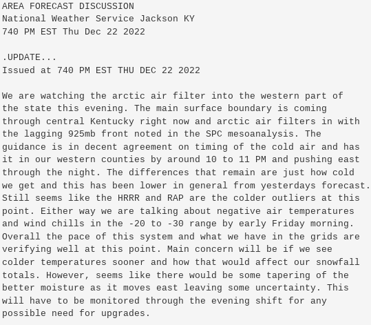
Latest discussion update from NWS Jackson...So I am sort of confused on this. If there is "tapering of moisture", why would an upgrade be necessary? Can someone explain this to me?
-
6 minutes ago, John1122 said:
I'll have my fingers crossed for you. As the crow flies we're only 20 or 30 miles apart.
Same for you. I've actually never been to Campbell County; I have been to Claiborne numerous time, though.
-
2 minutes ago, John1122 said:
I'd think your floor is probably 1 inch, and 2-3 wouldn't surprise me.
Sounds good to me lol. Thank you.
-
45 here at the moment in northern Bell County, Kentucky. I am hoping for at least 1 inch of snow, but I would love an overachiever!
What do you all think the potential is of that happening? Just figured I'd get some opinions for SE KY.-
1
-
-
52 minutes ago, ShawnEastTN said:
Anyone notice the clipper on the 18z GFS after the storm. Would be nice to get snow while we've been below freezing for a few days. With the deep cold behind this system a clipper can drop a nice high ratio snow.
Sent from my SM-F721U using Tapatalk
I noticed that as well. Hopefully it will continue to show up and eventually pan out.
-
1
-
-
From their latest discussion:
-
3 minutes ago, PowellVolz said:
MRX is starting to downplay the backside snow. Not that they ever played it up or anything but they are saying the mods are trending away from snow. I haven’t been able to looked deep into the mods but reading this board gave me the impression that we held steady or maybe got a little better today.

.NWS Jackson is currently thinking around an inch overall:
QuotePresently, snowfall amounts look to be around an inch. Snowfall amounts are very dependent on the track which could change drastically based on the final track of the low.
-
2
-
-
14 minutes ago, PowellVolz said:
If you’re looking to get your heart broken, you came to the right place.
Welcome aboard
.Thank you!
")
-
1
-
-
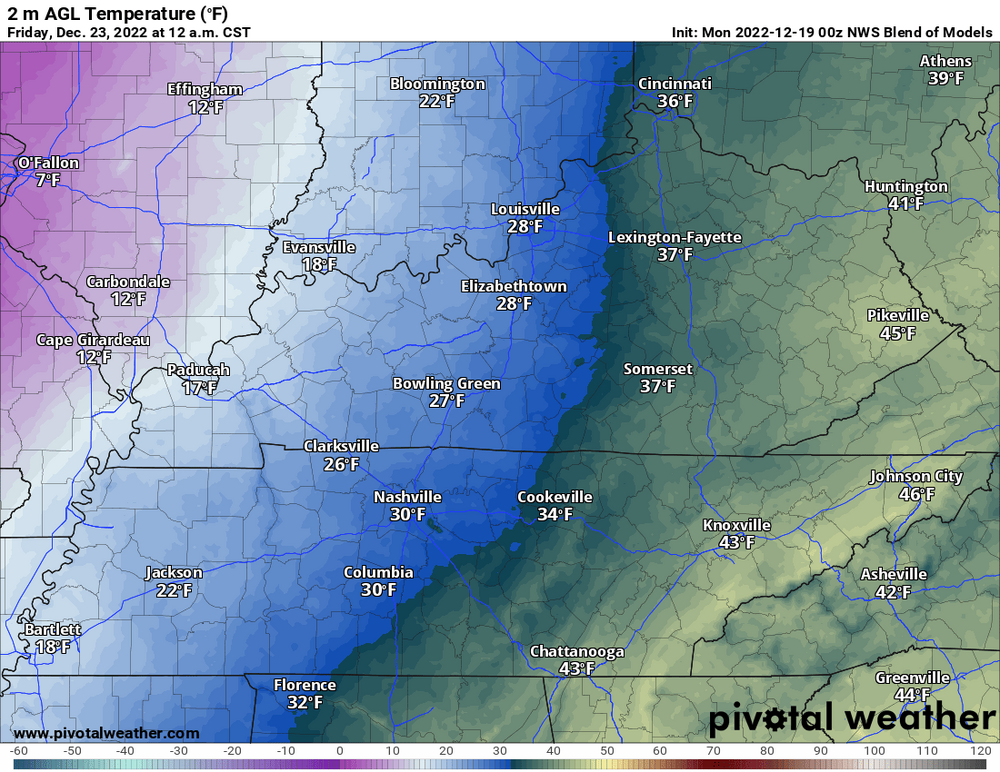
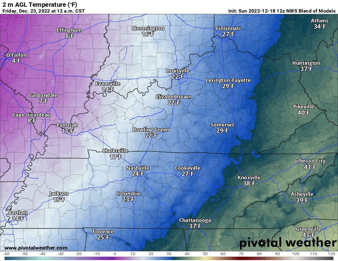
Hi, I just wanted to chime in and say that I've noticed the models have been delaying the ETA of the colder air on Thursday night/early Friday morning.
I have been looking at the last several runs of the NBM (Model Blend). At 12z-18th run of the NBM for example, Somerset, KY's forecasted temp @ 1 am Friday was 29F. And as of the 00z-19th (latest) run, the forecasted temp for that same hour is 37F.

-
4
-
-
We already have a coating of snow on the ground here in Northern Bell County. But there also has been some sleet and/or freezing rain falling as well. It looks to have tapered off as of 8:10...Temperature 32F
-
6
-
-
Seems to me that this is likely to become more of a now-casting event than anything.
-
1
-
-
4 minutes ago, EastKnox said:
Now I'm just hoping for some clear skies so I can get out the telescope.
I don't know whether to laugh or feel bad....Lol
-
What is everyones thoughts on snowfall and/or ice fall for Bell County (2 miles from the Clay line)?
Does it appear that our chances are shrinking as well? Be honest, I will take it the best I can

-
1 minute ago, RawCrabMeat said:
GFS 0z out yet? That one has been solid all along and we're just about in nowcast territory
I think it comes out in the 10 PM hour.
.png.17fb58d55fa72ef950cfcf4a8c5f8967.png)

Cold Shot: Part Duex - January 18-20th Arctic Blast and Freezing Rain/Snow Event
in Tennessee Valley
Posted
In Northern Bell County, we've had some light snow the last while. It's tapered off now, though.
Could we see another surge before the night is over? Current temp: 32F