

li_wx88
-
Posts
18 -
Joined
-
Last visited
Content Type
Profiles
Blogs
Forums
American Weather
Media Demo
Store
Gallery
Posts posted by li_wx88
-
-
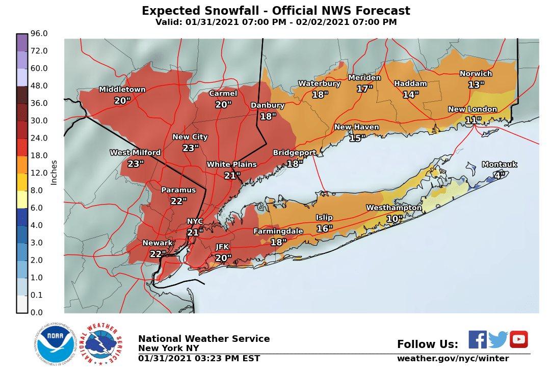
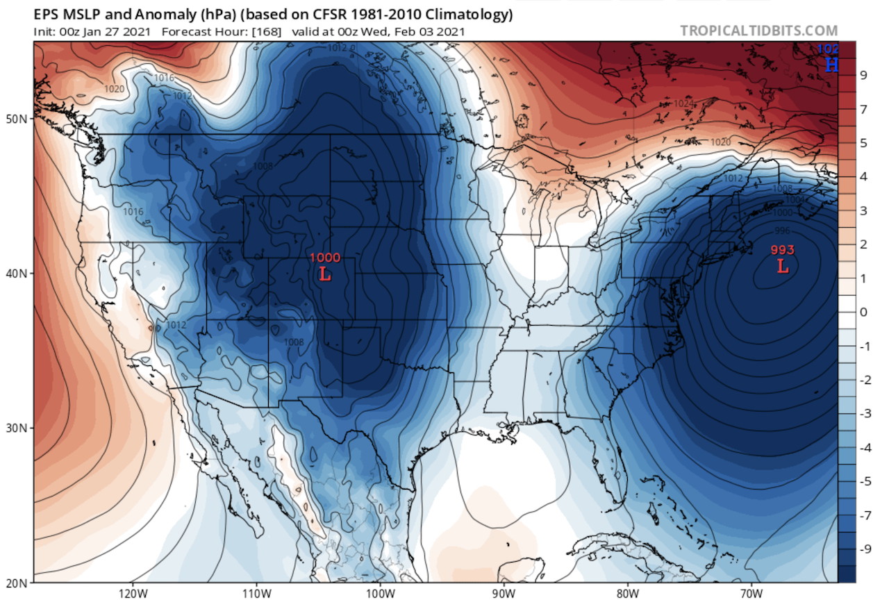
From the NWS area forecast discussion;
"Guidance continues to trend colder with the system with the low
track generally near the 40n...70W benchmark. However, global
models are in good agreement with a long period of light to
occasionally moderate snow through Friday as multiple waves
passes to the SE. The NAM remains an outlier with strong
frontogenetic banding to the NW of the first low on Thursday
with the potential for heavy snow, especially along the coast.
It produces liquid equivalent amounts of a half inch at the far
NW corner of the Lower Hudson Valley to over an inch across the
NYC metro and LI by early Thursday evening. There is also a
strong upper jet to the NW of the area. However, in assessing
the guidance, the better jet dynamics appear to come in Friday
as the RRQ of the upper jet approaches. Additionally, while
there is a strong baroclinic zone to the NW of the low track,
the low is fairly weak and the best thermal forcing may reside
just south of the area. Overall,the NAM seems to be overdone
with the lift, but at the same time it has been consistent over
the last several runs. Still though, it like the global models
has continued to shift to the south with the frontal zone and
low tracks. This will have to be watched closely today to see if
it falls into the consensus with a longer, drawn out snowfall
event. In fact, much of the guidance points to snowfall amounts
of 6 to 8 inches across the area, but over a 24 to 36h period.
Warning criteria is 6 inches or more in 12h, or 8 inches or more
in 24h. The latter is looking more likely at this time." -
3 minutes ago, HVSnowLover said:
Virginia Beach got snow once this month so there are occasional storms that don't trend north.
I know I know, was just having a bit of fun with it. No hard feelings.
Those guys just screwed more often than not.
-
3 minutes ago, HVSnowLover said:
Yea that's unfortunate but they may cash in on the next wave which looks pretty surpressed to the south
Have we learned nothing????
-
 2
2
-
-
12 minutes ago, jm1220 said:
RGEM was wetter.
Forgot to check that, it is for sure what they're looking at. Good call.
-
1 minute ago, HVSnowLover said:
These numbers look like a long shot right now, maybe upton expects models to tick wetter today?
That has to be it, its News12 so huge grain of salt needed but they just mentioned they're sticking with the higher totals for now and not trusting the 6z drier runs yet.
-
Very surprised that Upton and the local news guys are posting some of the totals that they are given the drier runs especially on the 6z GFS and NAM.
-
 1
1
-
-
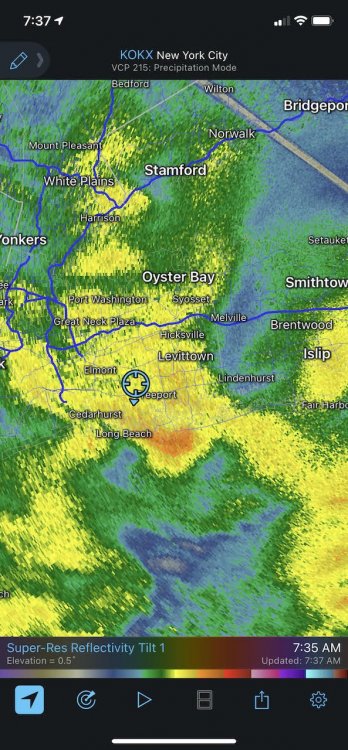
In western nassau here, what is the consensus on LI getting more accumulating snow?
-
Absolutely dumping in Rockville Centre right now (western Nassau). With that low setting up a bit east of what was expected, curious if that's gona shift that jackpot this way.
-
Just now, jm1220 said:
We probably mix over at some point but it would be as the heavy precip is leaving/gone anyway. It could just be a long period of drizzle.
By the time most of the island mixes, we will have either cashed in or busted anyway. Anything at that point woulda been relatively marginal anyways.
-
3 minutes ago, mannylovessnow said:

NWS NY is all in.
Beat me to it, I guess the NWS doesn't have access to the RPM model like all the local tv outlets!
-
4 minutes ago, LibertyBell said:
Boston is also going to be mostly rain, it's for this reason I live on the extreme western end of Long Island, we dont usually change over on this kind of track (a good example is the Millenium Storm, which actually tracked west of where this one is supposed to go.)
News12 is always riding the mix/rain train, not saying it won't happen but think its going to be limited to the forks/montauk.
-
 2
2
-
-
7 minutes ago, HVSnowLover said:
The overnight runs were not a good trend for LI but that front end thump means business, this is a foot plus before any mixing/dryslot. Hope the nw trend stops though as any further NW and it’s December all over again with long dry slot and mixing for a lot of us.
Curious to see if the NW bump is being a bit overdone at the moment and we see it adjusted in the 12z's
-
1
-
-
-
4 minutes ago, North and West said:
I received a new EGo snowblower for Christmas... so we've had about 2"+ since then. I'm just hoping that if it snows, there's enough to use my new snowblower at least once before winter winds down.
Curious to hear how that handles a bigger storm, single or two stage?
-
Just now, LibertyBell said:
I mean the chances with these kinds of storms are that a large percentage of people will get "stiffed" unless it becomes something on the scale of Jan 96 or Feb 03.
It could even seem like you wont get stiffed within 24 hours of the event.........and still get stiffed! Remember March 2001, February 2013 and January 2015? The last two were relative "stiffages" but we didn't get the 2-3 feet that were expected.
Remember them all too well! My fingers are crossed for this one, dying to bust out that new Ariens.

OBS and nowcast 10A-5P both Mon and Tue 2/22-23
in New York City Metro
Posted
Dumping snow here in Rockville Centre, obviously not sticking to a damn thing.