twisted.minds
-
Posts
6 -
Joined
-
Last visited
Content Type
Profiles
Blogs
Forums
American Weather
Media Demo
Store
Gallery
Posts posted by twisted.minds
-
-
I already know Weather.com and all them other crappy websites, I'm just trying to find a software equivalent to F5 or Radar scope.
If there are any suggestions, let me know.
Thanks!
-
This is a rendering problem with the radar dish itself. This is just a higher watt rating then it normally is.

If there is a high dew point in the morning rush, the radar would show up like this:
.
With nothing on the radar, It would show a few specs of visible moisture on outside the radar or directly on it. this is a sign that the station is working!
If there is more information needed, feel free to ask.
-
Edit: I will also be describing weather patterns for the next upcoming storm
-
This is some good information, thank you.
-
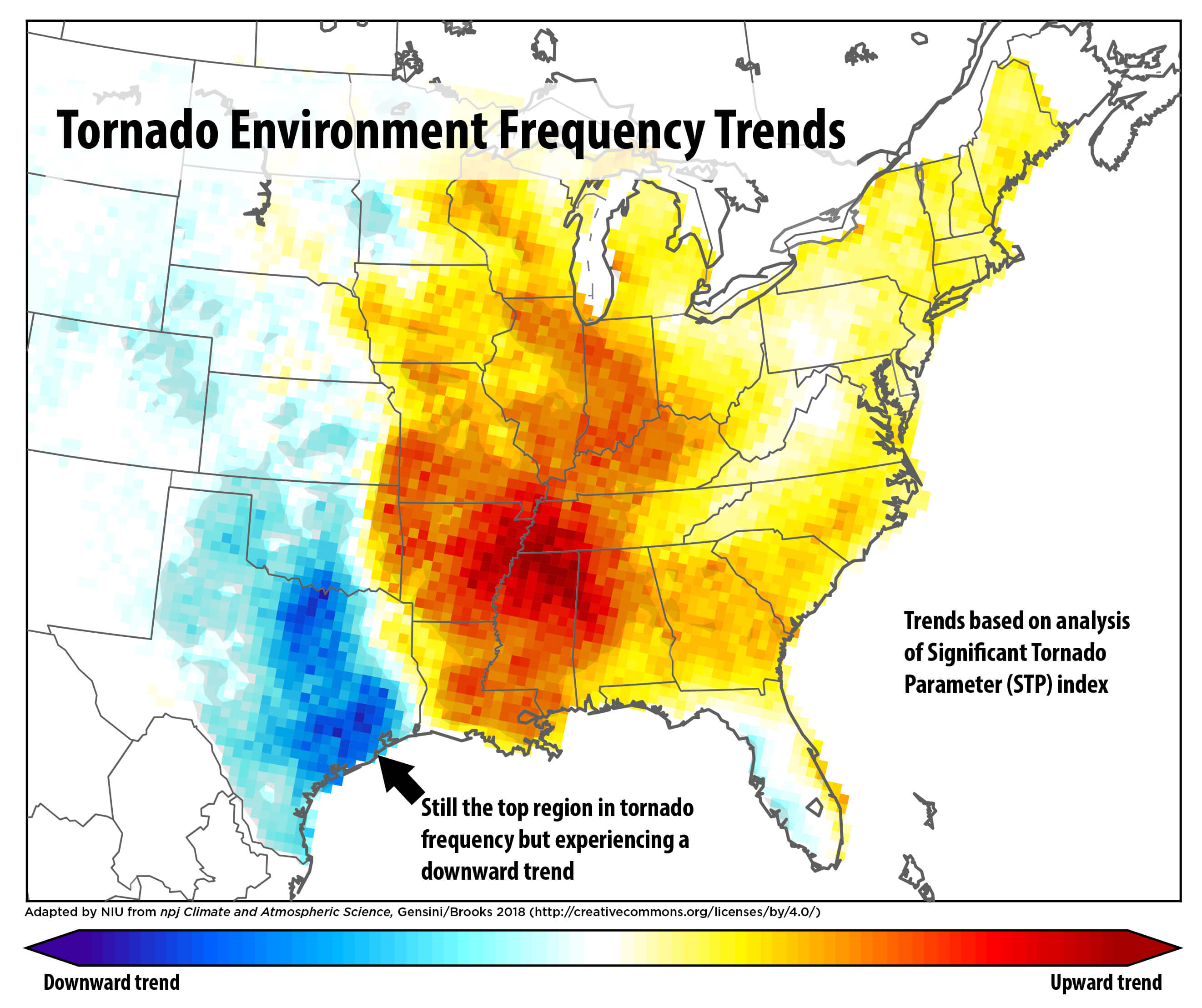
NIU Newsroom - A study, by meteorology professor Victor Gensini of Northern Illinois University found significant decreasing trends in frequencies of both tornado reports and tornado environments over portions of Texas, Oklahoma, and Northeast Colorado. The Researcher identified significant increasing trends of tornado reports and tornado environments in portions of Mississippi, Alabama, Arkansas, Missouri, Illinois, Indiana, Tennessee, and Kentucky. Searching deeper into it, he talked about how he used Tornado Reports as a tool. The thing that caught my attention was the fact that he used previous data from the 1950’s to mid 2018 for his studies.
Baised off of his claim, can we say that Dixie alley shifted?? lets find out.
Two things will be proven
1. Does The ENSO play with Dangerous Tornadoes and how frequent they are? (El Nino/La nina effects the map?)
2. Is the map correct about Dangerous tornado frequency?
Lets get started...
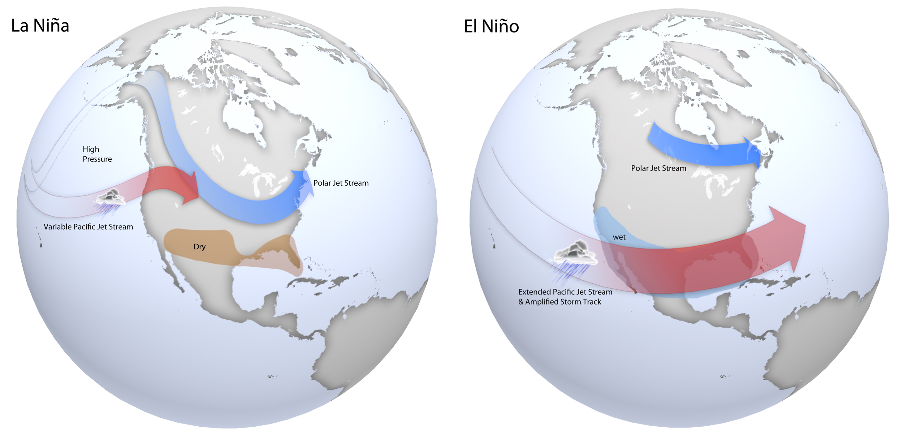
According to Trent Okerson, he said that A study by Cook and Schaefer suggests that ENSO plays a large role in the seasonal positioning of the jet stream, which is a major player in where conditions favorable for thunderstorm development will set up.
http://What is El Nino/La Nina?
Is there a higher frequency in El Ninos?
According to the National Ocean Service, they did say that El Nino's are more frequent than La Nina's. With previous statements telling you that El Nino's has less tornadoes than La Nina's, maybe we can see if there is a change for Dixie alley?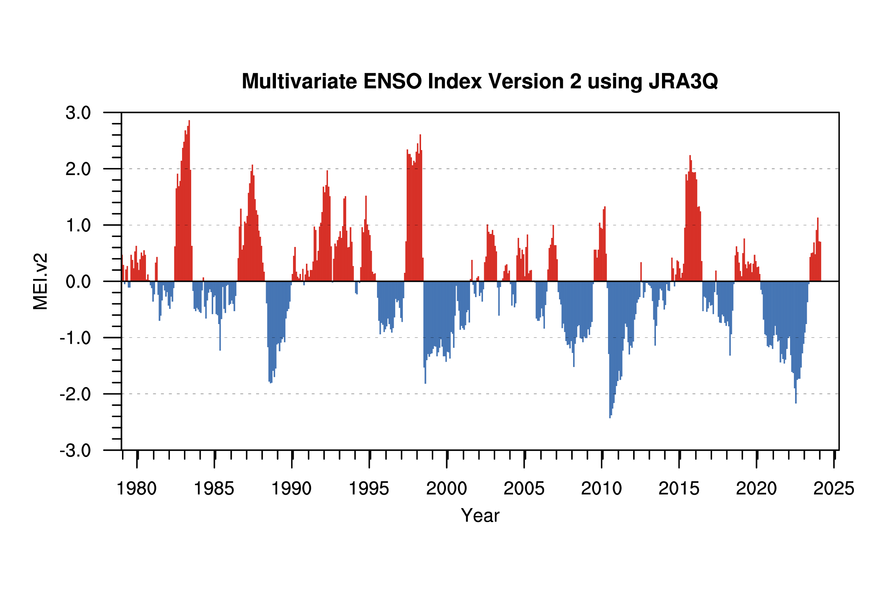
La Nina's happen less than El Nino's. Every tornado found in northern Mississippi that has been EF4+ has been a La Nina Year (To my knowledge at least)
Below is the most incredible piece of information to this document.
This is a google drawling of EF4 and EF5 tornadoes from 1925 - 2019: 1925 - 2019 Tornadoes
Unfortunately, this map is incorrect... would of moved the red spot into the northern part of Alabama.
Our next topic will be on 2020 severe weather and how it will play out this year.
the kuchera method is stupid
in Weather Forecasting and Discussion
Posted
Correct. It could be much, much worse though.