

Crowbar
-
Posts
52 -
Joined
-
Last visited
Content Type
Profiles
Blogs
Forums
American Weather
Media Demo
Store
Gallery
Posts posted by Crowbar
-
-
30 minutes ago, buckeye said:
17 years ago and I lived under that 20” bullseye.
still paying the price for that one
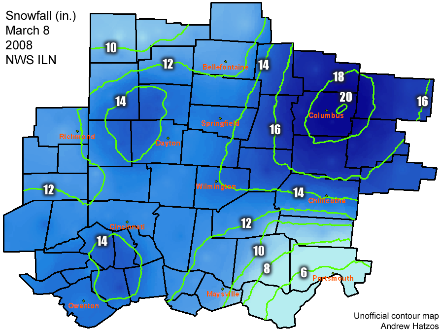
Will never forget this one. We live on the west side of Alum Creek park, and IIRC this storm started Friday morning as I worked until around 1:15-1:30, then kicked my assistant out and told her to go home and I left right after her. Lots of snow until evening when it stopped, then started back up in force overnight into late Saturday afternoon. There was even a blizzard warning for Friday, but not sure if conditions met the technical blizzard definition for winds. This is the heaviest snow I can recall since I was a kid living in NE Ohio.
-
For Central Ohio peeps - this is too bad:

-
 1
1
-
-
Central Ohio weather for the forseeable future:

-
 1
1
-
-
2 hours ago, pondo1000 said:
Crazy to me that we can’t even score a clipper out of this pattern.
These next few weeks, I fear, are going to be boring.
-
6 minutes ago, dilly84 said:
It's becoming increasingly obvious that for whatever reason Central Ohio just doesn't get decent snows anymore. It's still early in the winter, but this one is aggravating.
Think we’re just in a bad spot - no LE, and we need just the right path to get any good snows.
-
Nothing in Orange Twp. Told my kids to be ready for school tomorrow.
-
52 minutes ago, buckeye said:
12z hrrr
do we believe?

Would love to, but think we're only going to get a few inches at best. Other models showing more south. Already told my wife and kids that they'll have school tomorrow.
-
1 minute ago, pondo1000 said:
Live in Olentangy SD too. You fart a flurry & kids are off! Columbus will be open I bet.
No kidding - they also get a day every other week off anyway
-
1
-
-
Curious if schools will open - wife teaches in Columbus and kids go to Olentangy.
-
5 minutes ago, pondo1000 said:
I forget, criteria for warning in DE County versus Franklin County?
I think they're the same - it's when you get down toward Pickaway/Fairfield etc where the WSW criteria is lower, but someone more knowledgeable than me can chime in. I'm in Delaware County as well on the west side of Alum Creek
-
1 hour ago, buckeye said:
I’m guessing, ILN will put those northern tear of watches over to advisories and leave the warning counties as warnings. Unless we see something dramatic with the euro which is very unlikely at this point. Probably something like 3 to 6 across Columbus 2 to 4 once you get into Delaware County. Admittedly, i feel like that’s conservative, but my guess on what they go with. I’ll throw out my guess later.
But recently, how many times have we seen advisories get upgraded back to warnings once the storm evolves hopefully that’ll be what happens this time.Of course, you're correct - WWA just issued
-
So we get lots of cold without much in the way of snow - such is living in Central Ohio
-
Maybe we'll get lucky. Recall Dec 2013, when we were supposed to get 10-12" on Thursday night-Friday and ended up with only about 3" as the storm moved about 60-70 miles to the south (areas like Chillicothe got a foot that we were supposed to get) - maybe this time the weather gods will push this thing north to give us something worthwhile
-
Still have nightmares about Jan 2019, when we were supposed to get around a foot on Saturday, and instead got a few inches (granted overnight was lots of blowing/drifting with bad roads) preceded by rain due to WAA.
-
2 hours ago, buckeye said:
these one day brutal cold shots interrupting our 40s and 50s are annoying as sh#t. Like getting a bucket of ice water dumped on you .
If we'd at least get some decent snow out of the cold shot - unfortunatly, it's usually a high of low 20's with sun. Give me upper 20's-low 30's with snow
-
I'll continue to bump to the top, in the extremely faint hope that we get a major storm in the OV around Christmas Eve so I can get out of visiting the annoying part of my wife's family. Know that it won't happen, but will continue to hope beyond hope.
-
 1
1
-
1
-
-
This sums up the weather here in Central Ohio for the forseeable future:

-
Total bust here today - not a drop since some this morning that ended around 7:30
-
1 hour ago, buckeye said:
got some rain....even down pours! Definitely too little too late for a lot of our perennials and some shrubs but I'll take it
Where are you? I'm at Polaris, and nothing here at all. Starting to wonder if we'll even get anything.
-
On 5/16/2024 at 1:23 AM, dilly84 said:
Love him or not, a Columbus legend is calling it a career. So long, Jym! Maybe he'll join us here on the hobby side!
Played softball against him around 30 years ago - he was pretty good. The two games that I played against him he was their pitcher.
-
43 minutes ago, Floydbuster said:
Here it comes already and this is just slow moving round one.

Yep - I'm in the county north of Columbus. I don't see severe happening here, but ILN still saying that there's a chance. If it appears that they'll get severe, then I'll go home and work from there. Easier to work at the office, but would rather have the car in the garage and a basement if necessary
-
3 hours ago, Floydbuster said:
I'm surprised they went with such a high risk. There could be alot of rainfall throughout the day Thursday helping to lower instability in the region, similar to last week. Thankfully, this is much less threatening than last week, however, the focus will be more on flooding rainfall threats.
The NWS says the severe risk is highly dependent on lingering rain and clouds through the day. I think this has a high bust potential.
Agree - heard a local met on the radio talking about how it may clear out enough to fire up the storms, and that's what they said last week. Don't see that happening with the amount of rain we're supposed to get.
-
1
-
-
3 minutes ago, Floydbuster said:
Well other than the early Monday morning HRRR and NAM nightmares showing a possible big outbreak *perhaps* getting to Central Ohio, there was always the likelihood that it would be worse down near the Ohio River and Kentucky.
When the moderate risk was held over that area, there was a massive social media twitter meltdown among the amateur storm chaser nerds. They were attacking some forecaster named Broyles or something and going nuts. Then you had the long discussions and a tardy issuance of the moderate risk Mon afternoon smack dab over Central Ohio, way too far north without more model run indicators. By Monday evening, it was obvious that should be moved southwest, which it eventually was.
I know this seems unlikely, but is there a chance that the moderate risk was issued out of pressure from the social media freakout and the overperformance of the March Western Ohio tornado event?
Certainly hope it was more due to the overperformance from a couple weeks ago, as it's a pretty sad state of affairs if they caved to pressure from social media. I was wondering why we stayed in a moderate risk after all of the rain that we had overnight and this morning, then the one early this afternoon. The TV mets who were on the radio were still saying that we were in a moderate risk this afternoon, but the sun wasn't out that long today for any destabilizing to occur. Totally understand that it's not an exact science, but never saw where the necessary factors would be in play up here.
-
2 minutes ago, buckeye said:
Yep, it held
")
Yep - as I said above, when I got the call that school was letting out early, knew that it was game over. Certainly don't fault the school district with all of the hype, as there was some chatter about a Xenia-like event.

March 30 Severe Weather
in Lakes/Ohio Valley
Posted
In the slight risk area and not real far from the enhanced risk - have to work Sunday so guess I'll do that from home. No point in having my car getting pelted plus want quick access to the basement if necessary.