

Arctic Octopus
-
Posts
13 -
Joined
-
Last visited
Content Type
Profiles
Blogs
Forums
American Weather
Media Demo
Store
Gallery
Posts posted by Arctic Octopus
-
-
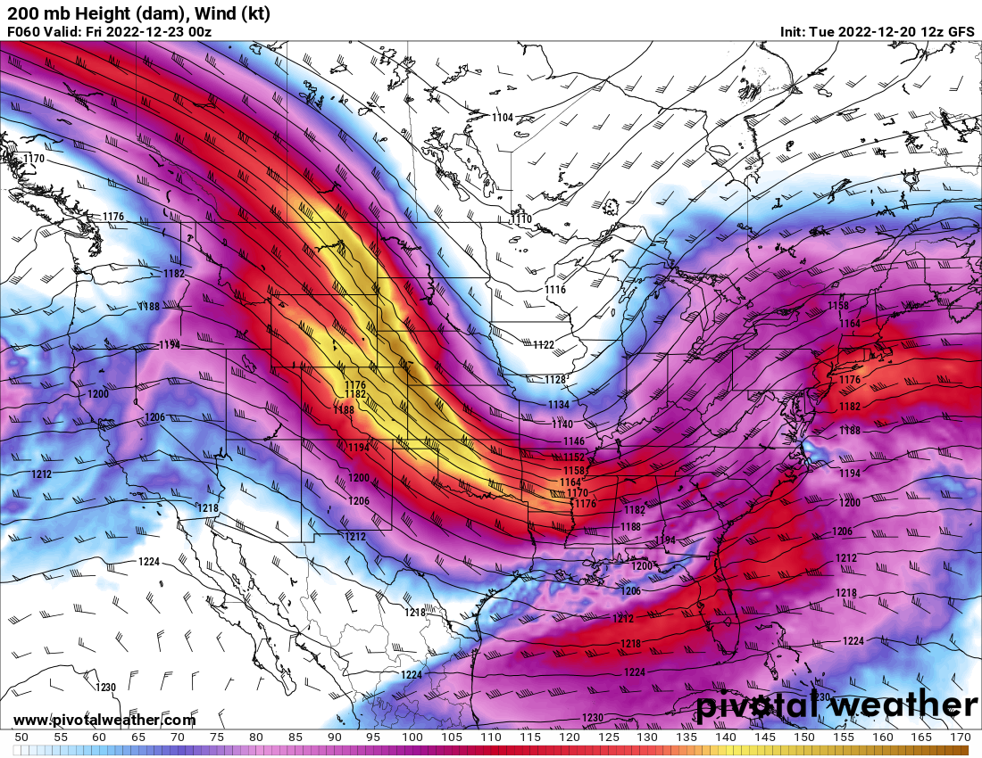
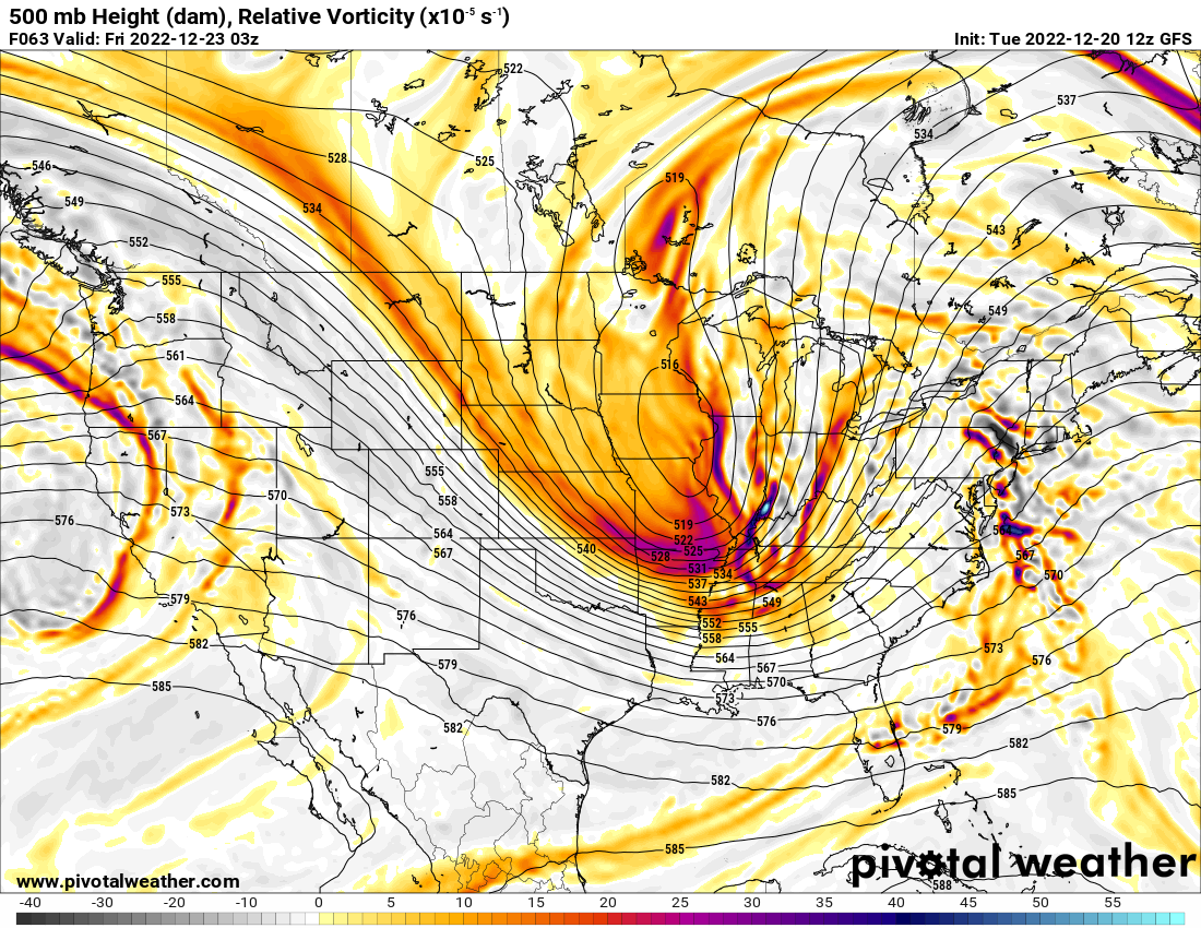
To my eye, the upper dynamics of the system still doesn't mesh with the surface picture the models are putting out. I would think that a system with a jet streak like this

Should have a more consolidated vort field than this
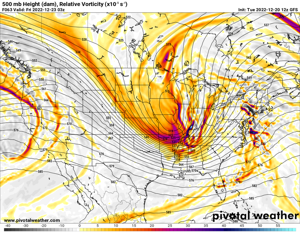
My guess would be that the remnant jet over Wisconsin on Wednesday develops just enough to muddy the axis and delay the main jet from consolidating. But if you look at the strength of the two streaks, you'd think the southern one would be bullying the northern. Not the other way around.
-
 1
1
-
-
9 minutes ago, Kaner88 said:
I've got family wanting to know if they should make the drive from Nashville to Chicagoland Friday; my initial reaction was no but if we're set to get like 3" in the city, doesn't strike me as the kind of crippling blizzard set-up that was being advertised (both in terms of amounts, obviously, but also shifting the focus of winds east towards MI). This is a mess
Rain to ice would still probably be an issue. Dropping down to single-digit temperatures immediately after .5-1 inches of rain would make most roads pretty sketchy I'd imagine.
-
 1
1
-
-
It looks like GFS, CMC and Euro all show a secondary low forming going into Monday morning. It may not be snow verbatim on two of the three but I would assume that's a hopeful sign considering most models were dry after the primary passed through and now they may be caving to the snowier GFS?
Sent from my Pixel 2 XL using Tapatalk -
Are there any natural reasons for a clear air downburst effect like what's showing up near New Kent?

Sent from my Pixel 2 XL using Tapatalk -
These are some fat flakes coming down right now. I think we're up to about 2" in Solomon's Island.

Sent from my Pixel 2 XL using Tapatalk-
2
-
-
Silver lining to if this verifies is that maybe it staves off the effects of a southeast ridge for a few days? We've seemed to fail with everything else so maybe if we pre-chill our warm sectors we can come up with something.Ouch. This looks familiar
Sent from my Pixel 2 XL using Tapatalk
-
Solomon's Island saw some mood flakes from about 1000-1100. Looks like it has mostly stopped by now.
-
It looks like it's a matter of how the models treat the following NS and SS waves following the Saturday event? GFS has the NS wave as stronger which pulls everything North and keeps it pretty progressive. The ECMWF has the SS as stronger and pulls the merger south and along with it a decent amount of cold air. Then a second NS wave is able to come in and take advantage of the cold air mass.
ETA: It looks like the CMC does the same thing as the ECMWF except that second NS wave doesn't get quite as far south.
Sent from my Pixel 2 XL using Tapatalk
-
BWI: 13.8"
DCA: 9.1"
IAD: 15.2 "
RIC: 4.3"Tiebreaker (SBY or LYH): SBY 2.2"
-
Seeing first flakes in Solomon's, Md.
Sent from my Pixel 2 XL using Tapatalk -
33 minutes ago, eurojosh said:
Likewise the Fv3-GFS is very close with back to back snowstorms in that timeframe - it misses north on both occasions, but is enough to stay interested for now.
To my untrained amateur eye, it seems like what I can see of the 12z euro output echo the Fv3 regarding the threats early next week. I only have the TT slides but it looks like the low placement and thermal structure match.
-
1
-
Pre-Christmas (Dec 21-23rd) Winter Storm Part 2
in Lakes/Ohio Valley
Posted
HRRR looks to be weaker on that lead shortwave through hour 6. May help with main low consolidation as it tilts negative.