

northwestgastormdawg
-
Posts
18 -
Joined
-
Last visited
Content Type
Profiles
Blogs
Forums
American Weather
Media Demo
Store
Gallery
Posts posted by northwestgastormdawg
-
-
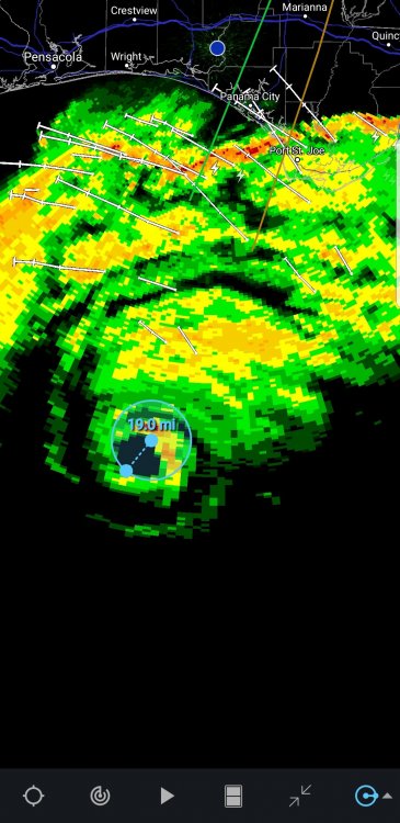
Beam height is about 8k
-
MICHAEL RECON DATA Dropsonde just measured incredible wind speeds aloft in the eye wall. 176 MPH around 1000 feet, 181 mph around 3000 feet. https://t.co/qSkYAcjkRJ
-
Eye is slowly contracting. An hour ago it was about 25 miles across.
-
CDO is cooling rapidly again. Wouldn't be surprised if we don't already have a Cat 4 storm.
-
 2
2
-
-
Don't often see this wording. From NWS TALLAHASSEE:
Hurricane Michael Local Statement Advisory Number 14...RESENT
National Weather Service Tallahassee FL  AL142018
1257 AM EDT Wed Oct 10 2018 /1157 PM CDT Tue Oct 9 2018/

This product covers EASTERN FLORIDA PANHANDLE...FLORIDA BIG BEND...SOUTHEASTERN ALABAMA AND SOUTHWESTERN GEORGIA

**UNPRECEDENTED EVENT EXPECTED FOR THE FLORIDA PANHANDLE AND BIG BEND**
-
3
-
-
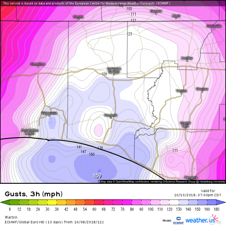
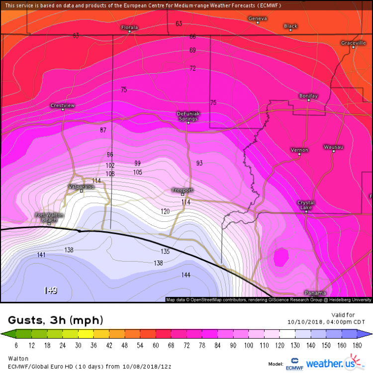
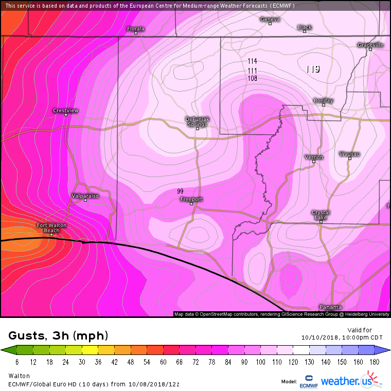
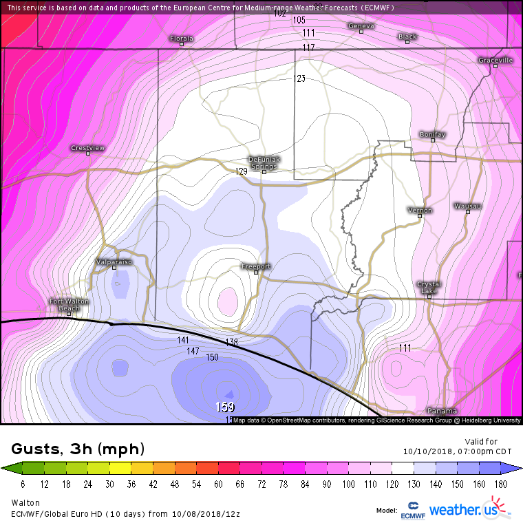
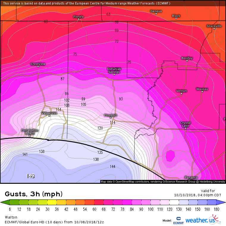
Here are Euro wind gust forecast for Destin area. Extreme gusts are shown

-
Looks like NWS Tallahassee is extremely concerned:
Hurricane Michael Local Statement Advisory Number 8
National Weather Service Tallahassee FL  AL142018
1143 AM EDT Mon Oct 8 2018 /1043 AM CDT Mon Oct 8 2018/

This product covers EASTERN FLORIDA PANHANDLE...FLORIDA BIG BEND...SOUTHEASTERN ALABAMA AND SOUTHWESTERN GEORGIA

***MICHAEL COULD DEVELOP INTO A POTENTIALLY CATASTROPHIC EVENT FOR THE
NORTHEASTERN GULF COAST***
-
38 minutes ago, ragtop50 said:
That is from the 5 a.m. discussion
Yes it is but the way things are going it is still a valid point for the future.
-
This sticks out for SC and Georgia
The NHC track has been adjusted southward at
days 4 and 5, and is a little north of the consensus out of respect
for continuity, however, the GFS, ECMWF, and the ECMWF ensemble mean
is south of the NHC track forecast, and additional southward
adjustment may be warranted in future advisories.
-
 1
1
-
-
-
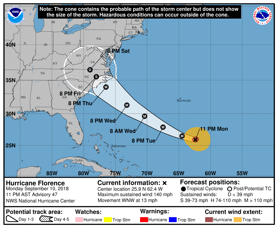
284
WTNT31 KNHC 110241
TCPAT1

BULLETIN
Hurricane Florence Advisory Number  47
NWS National Hurricane Center Miami FL       AL062018
1100 PM AST Mon Sep 10 2018

...FLORENCE CHANGES LITTLE IN STRENGTH DURING THE PAST SEVERAL
HOURS...
...HURRICANE AND STORM SURGE WATCHES LIKELY TO BE ISSUED ON
TUESDAY...


SUMMARY OF 1100 PM AST...0300 UTC...INFORMATION
-----------------------------------------------
LOCATION...25.9N 62.4W
ABOUT 465 MI...750 KM SSE OF BERMUDA
ABOUT 1085 MI...1745 KM ESE OF CAPE FEAR NORTH CAROLINA
MAXIMUM SUSTAINED WINDS...140 MPH...220 KM/H
PRESENT MOVEMENT...WNW OR 290 DEGREES AT 13 MPH...20 KM/H
MINIMUM CENTRAL PRESSURE...944 MB...27.88 INCHES


WATCHES AND WARNINGS
--------------------
There are no coastal watches or warnings in effect.

Interests in the southeastern and mid-Atlantic states should monitor
the progress of Florence.  Storm Surge and Hurricane watches are
likely be issued for portions of these areas on Tuesday.


DISCUSSION AND OUTLOOK
----------------------
At 1100 PM AST (0300 UTC), the center of Hurricane Florence was
located near latitude 25.9 North, longitude 62.4 West.  Florence is
moving toward the west-northwest near 13 mph (20 km/h).  A west-
northwestward to northwestward motion and an increase in forward
speed are expected during the next couple of days.  On the forecast
track, the center of Florence will move over the southwestern
Atlantic Ocean between Bermuda and the Bahamas Tuesday and
Wednesday, and approach the coast of North Carolina or South
Carolina on Thursday.

Maximum sustained winds are near 140 mph (220 km/h) with higher
gusts.  Florence is a category 4 hurricane on the Saffir-Simpson
Hurricane Wind Scale.  Some strengthening is expected during the
next 36 hours, and Florence is expected to be an extremely dangerous
major hurricane through Thursday.

Hurricane-force winds extend outward up to 40 miles (65 km) from the
center and tropical-storm-force winds extend outward up to 150 miles
(240 km).

The latest minimum central pressure estimated from Air Force
Reserve Hurricane Hunter aircraft data is 944 mb (27.88 inches).


HAZARDS AFFECTING LAND
----------------------
SURF:  Swells generated by Florence are affecting Bermuda and
portions of the U.S. East Coast.  These swells are likely to cause
life-threatening surf and rip current conditions.  Please consult
products from your local weather office.


NEXT ADVISORY
-------------
Next complete advisory at 500 AM AST.

$$
Forecaster Beven
-
WTNT41 KNHC 081453
TCDAT1

Tropical Storm Florence Discussion Number  37
NWS National Hurricane Center Miami FL       AL062018
1100 AM AST Sat Sep 08 2018

Florence has undergone a dramatic structural evolution just within
the past 6 hours or so.  Vertical shear has decreased just enough
for the storm to take on a more symmetric shape, with convection
developing in a ring around the low-level center, and an elongated
band wrapping around to the northeastern part of the circulation.
The convection has waned a little bit in intensity, however, due to
the presence of dry air, and Dvorak estimates support maintaining
an initial intensity of 55 kt for now.  A NOAA P-3 aircraft is
approaching Florence now on a research mission and should provide
some useful data to better assess the storm's intensity.

Recent WindSat microwave data revealed that Florence has a
well-defined low-level ring in the 37-GHz channel, which tends to
be a harbinger of strengthening when environmental conditions are
favorable.  Since vertical shear is decreasing and should be 10 kt
or less by later today, and Florence is heading toward a deeper
pool of warm water over the southwestern Atlantic, a significant
phase of intensification is likely to begin by tonight, continuing
through Tuesday or Wednesday.  In fact, the official intensity
forecast explicitly shows rapid intensification occurring between
24 and 48 hours from now, and Florence is expected to become a
major hurricane by Monday.  The HFIP Corrected Consensus (HCCA) and
the Florida State Superensemble (FSSE), both of which tend to do
well in these scenarios, are both near the upper end of the guidance
suite, especially through day 3.  Even by days 4 and 5, the HWRF,
HMON, and ICON intensity consensus are near the top end of the
guidance, close to HCCA and FSSE.  Given the signals in the
environment, and the solutions provided by these models, the NHC
intensity forecast shows Florence reaching category 4 intensity by
day 3 and maintains that through the end of the forecast period.

Florence's longer-term motion is 265/6 kt.  The cyclone appears to
be slowing down as was expected, and this type of motion is likely
to continue for the next 24-36 hours.  In fact, the track guidance
has slowed down during this period, and the updated NHC track
forecast is a little slower than the previous one.  After 36 hours,
the most notable change in the models was a northeastward shift in
the 06Z GFS.  However, that run appears to be an outlier from the
rest of the dynamical models, and its trend opposes the slight
westward shift noted in the HCCA and FSSE aids.  The updated NHC
track forecast is therefore very close to or slightly west of the
previous forecast on days 4 and 5.  The exact path of Florence as it
approaches the southeastern U.S. coastline will depend heavily on
the position and strength of the blocking high pressure that is
expected to develop north of Bermuda and extend westward over the
eastern U.S., and so far there has not been much more clarity on
those important details.

Key Messages:

1. Florence is forecast to be a dangerous major hurricane near the
southeast U.S. coast by late next week, and the risk of direct
impacts continues to increase. However, given the uncertainty in
track and intensity forecasts at those time ranges, it's too soon to
determine the exact timing, location, and magnitude of those
impacts.

2. Interests along the U.S. East Coast, particularly from north
Florida through North Carolina, should closely monitor the progress
of Florence, ensure they have their hurricane plan in place, and
follow any advice given by local officials.

3. Large swells are affecting Bermuda and will begin to affect
portions of the U.S. East Coast this weekend, resulting in
life-threatening surf and rip currents.

FORECAST POSITIONS AND MAX WINDS

INIT  08/1500Z 24.5N  54.3W   55 KT  65 MPH
 12H  09/0000Z 24.6N  55.0W   60 KT  70 MPH
 24H  09/1200Z 24.6N  56.1W   70 KT  80 MPH
 36H  10/0000Z 24.8N  57.5W   85 KT 100 MPH
 48H  10/1200Z 25.1N  59.3W  100 KT 115 MPH
 72H  11/1200Z 26.3N  64.9W  115 KT 130 MPH
 96H  12/1200Z 28.5N  71.5W  125 KT 145 MPH
120H  13/1200Z 31.5N  77.0W  120 KT 140 MPH

$$
-
Florence has been losing some latitude and the vertical stacking looks better this morning. Also becoming more concerned for areas further south towards S.C. and Georgia coasts. Very very susceptible to storm surge miles inland.
Hurricane Michael
in Southeastern States
Posted
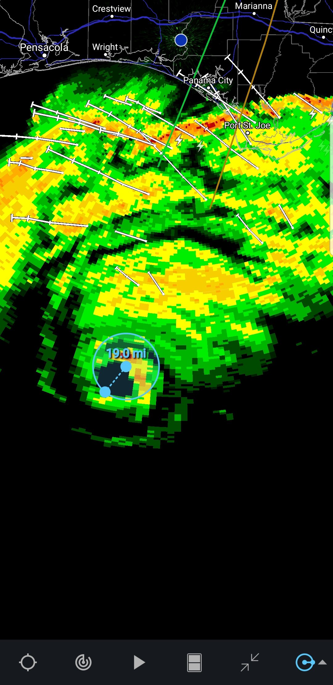
Definitely not weakening. Beam height is 6.7k ft.