

OutnOakmont
-
Posts
71 -
Joined
-
Last visited
Content Type
Profiles
Blogs
Forums
American Weather
Media Demo
Store
Gallery
Posts posted by OutnOakmont
-
-
While we are riding the edge, at least this doesn't look like the usual 'Youngstown Special'. I guess mother nature wanted to switch it up this time lol.
-
20 minutes and my yard and steps are covered.
-
Will we get some of the white stuff this week? I hate to admit that I could kind of go for one last hurrah this season!
-
 2
2
-
-
Really coming down now! The road is already covered and the snow back is nice and fresh.
-
I'm hopeful that we see at least a slightly different outcome. I feel like we've seen this pattern a few times this season where my whole family in Maryland looks teed up for a big one only to get 1-2" while we get 6". Is that high pressure in New England/southern Canada throwing us off the course? It seems to bounce around an awful lot with each model run. It went from sitting near the lakes earlier in the week to sitting right over Maine/Massachusetts as of late.
-
No watches or warnings! It's got to be a sneak attack overperformer for us. My superstitious side is really coming out now after getting burned yesterday haha.
-
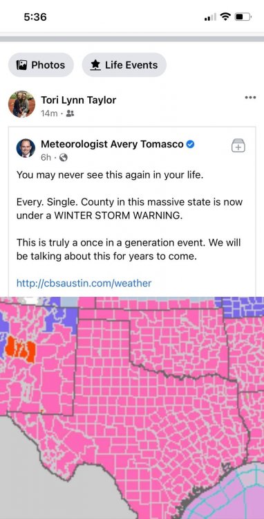
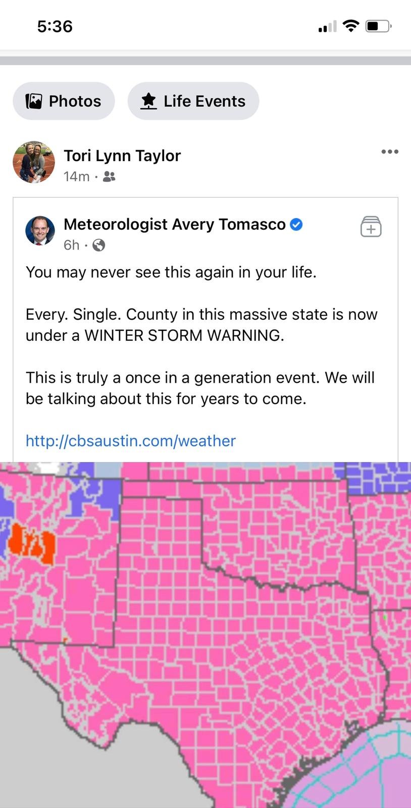
Slightly off topic, before moving to Pittsburgh, I lived in Frisco, TX, a suburb of Dallas. My friends down there were texting me this morning to revel in their 6" of snow this morning. It truly was an historic storm for them.
-
Forget Youngstown special, this is like a Cincinnati surprise. What a huge shift in the band of snow just since going to bed! The models, even my go-to Euro, really did a piss poor job with this one. I know we're all snow weenies here and are more sensitive than most, but I think there's certainly a case to be made for being really irked this time around. To see such a 180 within 24-36 hours of the event is disconcerting. In short, bah humbug with the whole dang thing!
-
This is superstitious as hell, but I told my other half that as soon as the winter storm watch was issued, it was going to fall apart. We only seem to do well when nobody is looking so to speak. We seem to do so much better with quick hit and run systems than anything with a wind up.
-
Interestingly, I've been following the GFSv16 maps most of the winter. Generally, it's been a real stick in the mud all season--even more than the Euro most of the time. The current run coming in right now actually trends better than it has all day. It went from 3.5" for AGC to now 8"... But just barely. It just seems like the cutoff is steep and the models really don't know where that gradient will set up shop. So in short, same old sad story. What do the people in the other forums for locations that get pummeled with snow fret about if it's not the WTOD or rain/snow/mix line? Lol
-
Just shy of 1" here
-
Just took my dogs out and measured about 5.25"!!! It's superstitious as hell, but it's like we do the best when the storms get very little attention, very little hype. We need more of these low-key sleeper cell storms haha
-
2
-
-
It's such a weird looking storm on radar. Sort of a weird polar express stretching across the Midwest.
-
RIPPING big time here! Probably a better rate in the past 20 minutes than rates for the entire last event.
-
I'd be happy if we could get 2" or maybe even 3" tonight just to spruce our leftover snow up again. Whatever hasn't melted in my yard is starting to look real sad haha
-
Exactly 3" here. Not the best, but better than a stick in the eye. My main hope for this storm was that I could try out my new snowblower that I got for Xmas. I think that I can justify using it with a solid 3" on the ground

-
38 minutes ago, Rd9108 said:
Btw looks like we track again after this one. This time a Miller A.
What day are we looking at?
-
Looks like it's FINALLY coming down at a good clip. The road and driveway just now got coated.
-
2
-
-
2 minutes ago, Mailman said:
Euro looking like a hit.
Yes!!! I'm refreshing my page to get the frames loaded and getting more and more excited haha.
-
It's a little unnerving to see such variation between the models. I know they're never in complete agreement, but it seems like with this storm in particular all of them take a different stab at the totals and all get very different results. Typically, I yield to the Euro no matter what. I wonder if it will come out on top this time around.
-
1
-
-
Just checked the Euro and almost fell out of my chair!!! Holy moly what an improvement! Hopefully we can hang on to the momentum and not see a deteriorating situation.
-
1
-
-
Gross. The early part of next week is really starting to look like a slopfest. It's disappointing to see the tongue emerge!
-
 1
1
-
-
It's beautiful outside. A very nice surprise for a lazy Saturday morning!! Probably 1" here so far.
-
I saw this story today about arctic air being "on the move". It'll be interesting to see if it has any impact on us. https://www.washingtonpost.com/weather/2021/01/05/polar-vortex-split-cold-snow/?outputType=amp
Western PA/Pittsburgh Winter 2021/22 Discussion
in Upstate New York/Pennsylvania
Posted
Anybody left who is looking at tomorrow and Tuesday?