

Jfreebird
-
Posts
24 -
Joined
-
Last visited
Content Type
Profiles
Blogs
Forums
American Weather
Media Demo
Store
Gallery
Posts posted by Jfreebird
-
-
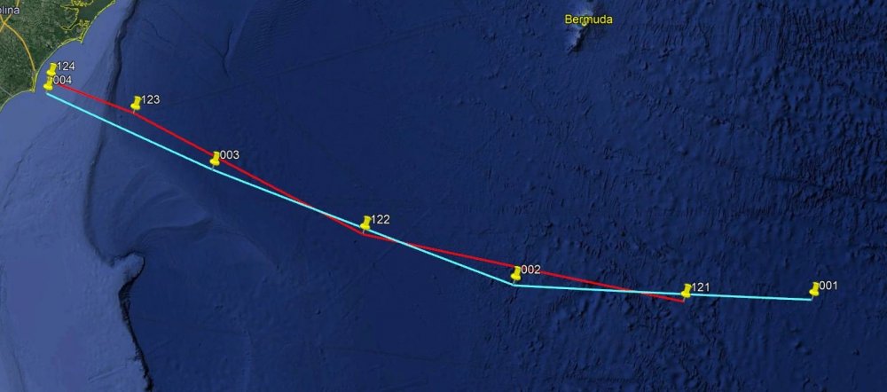
Red is 12z Blue is 00z interesting where they both ended up on 72hr
-
Can someone explain why more models are showing a loop? This is the latest 00z (not sure if this is the correct form to ask in)

Sent from my SM-G930V using Tapatalk -
SUMMARY OF 200 PM EDT...1800 UTC...INFORMATION
----------------------------------------------
LOCATION...22.8N 71.2W
ABOUT 90 MI...145 KM N OF GRAND TURK ISLAND
ABOUT 420 MI...675 KM ESE OF NASSAU
MAXIMUM SUSTAINED WINDS...125 MPH...205 KM/H
PRESENT MOVEMENT...NNW OR 330 DEGREES AT 9 MPH...15 KM/H
MINIMUM CENTRAL PRESSURE...959 MB...28.32 INCHES
-
I have a question/questions.... just because I love crunching data lol and I see a few outlying members with Maria... The ECMWF model Ensemble has 50 members.. Each of those members have a name IE EN01,EN02 etc....
1. Are there Ensemble members that are more accurate than others?
2. If so then what are they and where can you find a graph with the latest run that shows the ensemble members with their names?
Thanks for everyone's knowledge and help
-
I noticed a few things on the 12z GFS run
1. it has the storm traveling much slower compared to the past few runs.
2. The 12z GFS at hour 156 is almost exactly where the ECMWF 00z hr 168 has it..
-
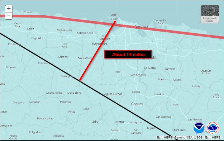
The 2pm track from the NHC puts the center of the eye about 14 miles out side of San Juan... Gonna be a long night
-
So I have a question/observation.... Is Jose a big driving force for irma? reason I am asking is over the past 3 ECMWF runs including the 12z run that is running now, The model has Jose losing intensity quicker ... If this trend continues will the models for maria start shifting more west?
-
1 hour ago, StormchaserChuck said:
Only 1 storm didn't hit America, and it was furthest NW of the bunch, soon to be nonanalog.
La Nina still being underestimated, I think
If the one that you are talking about the one with the loop its Jose lol

Major Hurricane Florence: STORM MODE THREAD
in Tropical Headquarters
Posted
Can someone tell me why it is loosing some of its reds and oranges on the IR to the north and NW of the storm? was looking at this IR loop for the past hour
https://weather.cod.edu/satrad/exper/?parms=meso-meso1-14-96-1-25-1&checked=map&colorbar=undefined