

drscottsmith
-
Posts
22 -
Joined
-
Last visited
Content Type
Profiles
Blogs
Forums
American Weather
Media Demo
Store
Gallery
Posts posted by drscottsmith
-
-
3 hours ago, SouthernVAwx said:
Worth noting the 12z GFS builds on a severe threat for Sunday evening.
I don't post often as I am still learning (and realize everyone is thinking about Tues/Wed right now), but I believe next weekend is going to be a serious situation...starting Saturday 3/9 and extending into Sunday. Not good on the heels of yesterday.
-
 1
1
-
 1
1
-
-
Light sleet in Duncan at 7:20 this morning. Surface temp is about 39 F.
-
Sleet has transitioned to snow in Duncan, SC. About 2.5 miles S of 85 at exit 63.
-
Been following the WECT livestream since yesterday (out of Wilmington). On their radar, eye seems to be moving clearly SW, and once it passes the Oak Island area, it looks like the eye will be back over water (a fair distance offshore) for a period of time. What will this do for strengthening before a second possible landfall in SC?
-
Hopefully not an incorrect question...
Do storm observations need to go in the Storm Mode thread (here) or will there be a separate thread?
-
Just now, lilj4425 said:
I think I should be the one who creates these winter storm threads from now on.
")
I'll second that! Good call!
Moderate + snow in Duncan, SC right now. Starting to stick to grass and vehicles.
-
I'm in the upstate of SC (Spartanburg County) - right along I-85...I hope this is an educated question...
What should we be looking for in today's weather pattern to ensure a best-case scenario as the moisture and cool air move in tomorrow? In other words, do we want temps to maintain, rise or fall today?
Is it better for dew point to stay low (dry) today so that moisture will cool the air column tomorrow as precipitation starts or would a slow rise in DP be better starting even today?
So many variables have to be "just right" that I am curious what actual observations today yield best results for tomorrow.
Thanks -
-
1
-
-
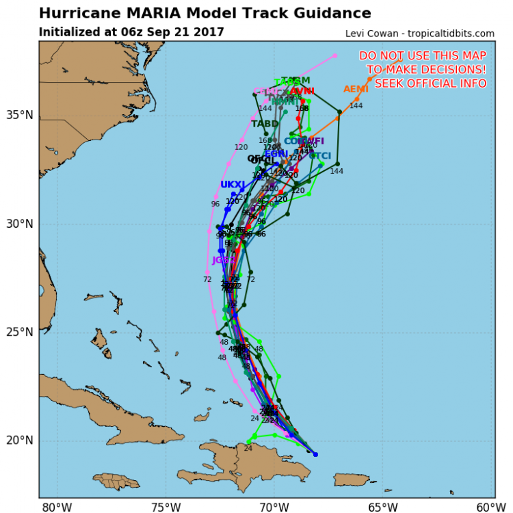
First post here all - trying to learn...
What is the difference in the track above when you look at TABD which has a very "jagged" track (with many sharp turns) versus 'most' of the other models which are much smoother in their path - is it a matter of the model's resolution?
-scott
March 2019 Observations
in Southeastern States
Posted
Sleet in Duncan, SC right now as well. Not at station to record temp.