

bjc3395
-
Posts
132 -
Joined
-
Last visited
Content Type
Profiles
Blogs
Forums
American Weather
Media Demo
Store
Gallery
Posts posted by bjc3395
-
-
Today is a difficult chase target for a litany of reasons both meteorological and non meteorological. I’m choosing to head for Norman. I don’t want to deal with the flooded/closed roads in NE Oklahoma and SE KS. Once again I think supercells will track along the zone of ascent causing destructive interference and less than friendly chasing. Throw on top of that increasing flash flood threat 00-03z and chaser convergence for SOC bullseye and I’m out.
Grabbing lunch in Norman and watching for anything SW-NW of I35.
Tomorkw looks far better. Currently targeting liberal/DDC/AMA.
Largely rinse and repeat Friday - Monday/Tues/Weds
-
Agreed. And anyone who says “it was X” is a fool. You can’t possibly know. The overlap between low level lapse rates for strong, tornadic, and non tornadic supercell cases is so big I’m not sure LL lapse rates are a good discriminator lol.
-
Re: tomorrow. There are some hints of CI from QPF trends on globals. SREF highlights potential too. HRRR is most aggressive. Maybe from overmixing? Is that still a bias with the HRRR? If so that would explain the convective scenario it depicts tomorrow vs the rest of CAMs
-
Also see way too much defensiveness from SPC/NSSL/NWS folks after a bust. Just admit it was a bust! Don’t try to tell people how 20+ QLCS tornadoes verify a forecast that called for discrete, long track violent tornadoes. Sure you may have quantitatively verified your forecast - but not qualitatively. Right for the wrong reasons if you will.
And I’m not even talking about yesterday, either. I just wish people had more humility sometimes. Every time we have a giant overforecast like yesterday the masses/fanboys come rushing to the defense of them like they’re being attacked. Come on folks. I have had my share of bad forecasts and been criticized. And yet I was better for taking the criticism to heart and analyzing what went wrong.
Not to say SPC guys should listen to criticism on Twitter. Whatever to that. But I do see a lot of this weird wagon circling every time there is a forecast bust. It’s okay to bust. They happen. Just look at Roger Edwards’ tweets today as a great approach to it.
-
 6
6
-
 2
2
-
-
9 hours ago, weatherwiz said:
Yes and no...yes b/c we will always be learning but in terms of yesterday I don't think it could have (or should have been handled any differently). While this bares true for any type of weather event, IMO this is moreso for severe wx, but mesoscale features and short-term evolution are extremely critical for these types of events. There are plenty of meteorologists who have presented some ideas as to why we didn't see a much larger number of tornadoes (and strong tornadoes). Keep in mind none of these thoughts are mine...I am presenting what I have read, but temperatures around 10,000 to 20,000' ended up slightly warmer, an increase in H7 frotogenesis helped nudge a push of warmer air here into OK. Forcing may have slacked a bit more.
I know "busts" hurt the credibility of forecasts, but the main goal for forecasters is protecting life and property. In a case leading up to yesterday there is no other way to handle that. You want to give people as much information as possible to protect their life...people are too easy to cry and complain, but those who went through a terrifying situation are likely to be extremely thankful.
What doesn't help the situation is the people who run around social media and cry bust after every weather event. Severe weather happened yesterday...and quite a bit...and in the highlighted area. People should be thankful we didn't see numerous strong-to-violent tornadoes and there aren't casualties (I have not heard of any...and hope there haven't been).
I’m an operational meteorologist who has done a research stint w/SPC before. I should have clarified what I meant. I would’ve issued the same high risk forecast Edwards did. We lack the obs network to avoid busts like yesterday. That fascinates me.
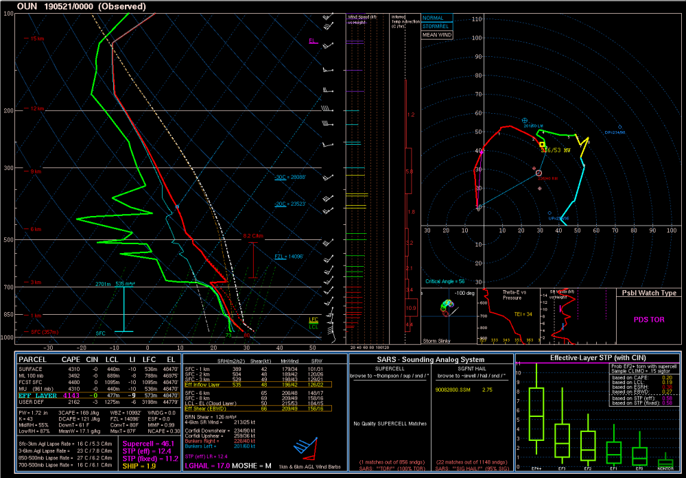
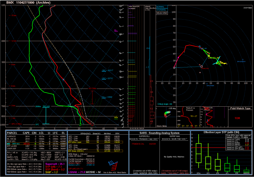
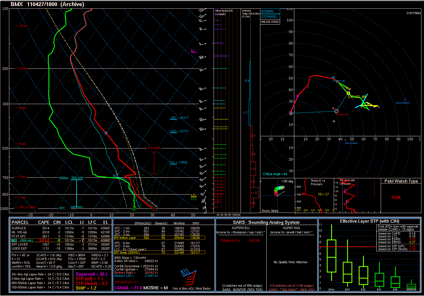
I am skeptical the capping alone did this event in. A comparison to BMX 18z sounding from 2011 shows an astonishingly similar profile. Same cap. It was probably a mix of multiple moving parts. It just didn’t come together. There were attempts at CI along multiple confluence axes that just didn’t pan out... this was for the better.
Just to clarify. Yesterday 100% was a bust, and a massive overforecast. Will probably end up verifying no more than a 15% moderate risk. Criticism is fine - we all make mistakes. My forecast busted just the same. Should I get all butthurt about people calling it a bust on social media? Absolutely not. It is part of the business. We learn and we move on.
So i repeat. We have much to learn!
-
2
-
-
This event is wildly fascinating to me. Extreme CAPE/shear combo and largely busted today. We have much to learn.
-
1 minute ago, jpeters3 said:
Nobody is complaining. Experienced professional meteorologists are providing objective analysis of the situation.
So you’ve got more experience than me. In a typical Plains setup i would agree that MCS in NW OK pretty much confines the front to I-40, maybe even S. But.. this is anomalous for the Plains. Would argue the LL flow keeps that boundary N of 40.. perhaps closer to 412. Your thoughts from experience?
-
Think the warm front is going to hang up roughly along Highway 412 in OK. Sure outflow will sag south some but anomalous low level flow regime will almost surely keep the OFB from surging south into I-40.
-
This is one of the few times the trend is going to a worst case scenario.
-
Probably skewed by CAMs with MCS/linear modes which produce large swaths of High UH usually. But the W TX signal is legit.
-
I like to use the HRRR as a time-lagged ensemble, and I gotta say.. The trends on the HRRR *aren't* pretty.
Potentially historic setup tomorrow.
-
8 minutes ago, jpeters3 said:
I wouldn't discount the CAM solutions as much as you suggested. CAMs generally do a good job of physically resolving the conditions related to the initiation and maintenance of MCSs (this is supported by research). It is possible that there are subtleties of the dynamics/thermodynamics that the model is capturing that are difficult to pick out of soundings.
Not necessarily discounting them but I think we get a long lived supercell event. At least til 3Z. That assumes the front isn’t shunted to ~red river or further south.
Looks pretty big time. At worst I think we are looking at a mixed mode by 01z or so. We will see. Think we all agree there’s a very high ceiling.. but definitely a low floor too, relative to many expectations.
Another day that has my attention is Wednesday despite rising heights. Seems globals show hints of diurnal CI along the dry line... environment is pretty ripe for tornadic supercells if we pop a few off.
-
At this point - glancing at summary of 12z guidance... I think so long as we don’t get a warm sector crushing MCS... this is bound for a borderline historic outbreak of tornadic supercells. I know that’s crazy to call >24 hours in advance, and I’m by no means saying Dixie level historic. But for plains events, I think we are headed for something very high end.. bordering on history making. CAMs are not built nor able to properly resolve discrete, propagating supercells.. this could easily be a long duration tornadic supercell event across E TX PH into W and C OK, and NW Texas. TTU WRF and NCAR ensembles show a strong signal for discrete modes maintained well after dark - into 5z. Again.. the CAMs you can access for free on pivotal.. especially the 3km NAM.. are not going to resolve tornadic supercells or a discrete fashion for long.
Personally this looks like a pretty prolific event - but the uncertainties as mentioned above preclude a high risk until perhaps even the 10 am update. But I think this is shaping up to be a memorable, long-duration tornado event.
-
27 minutes ago, jpeters3 said:
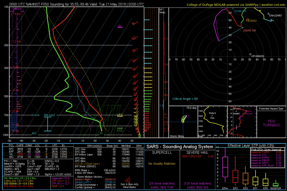
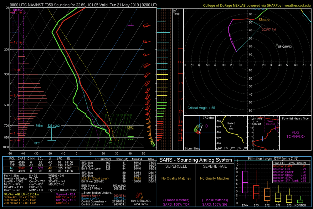
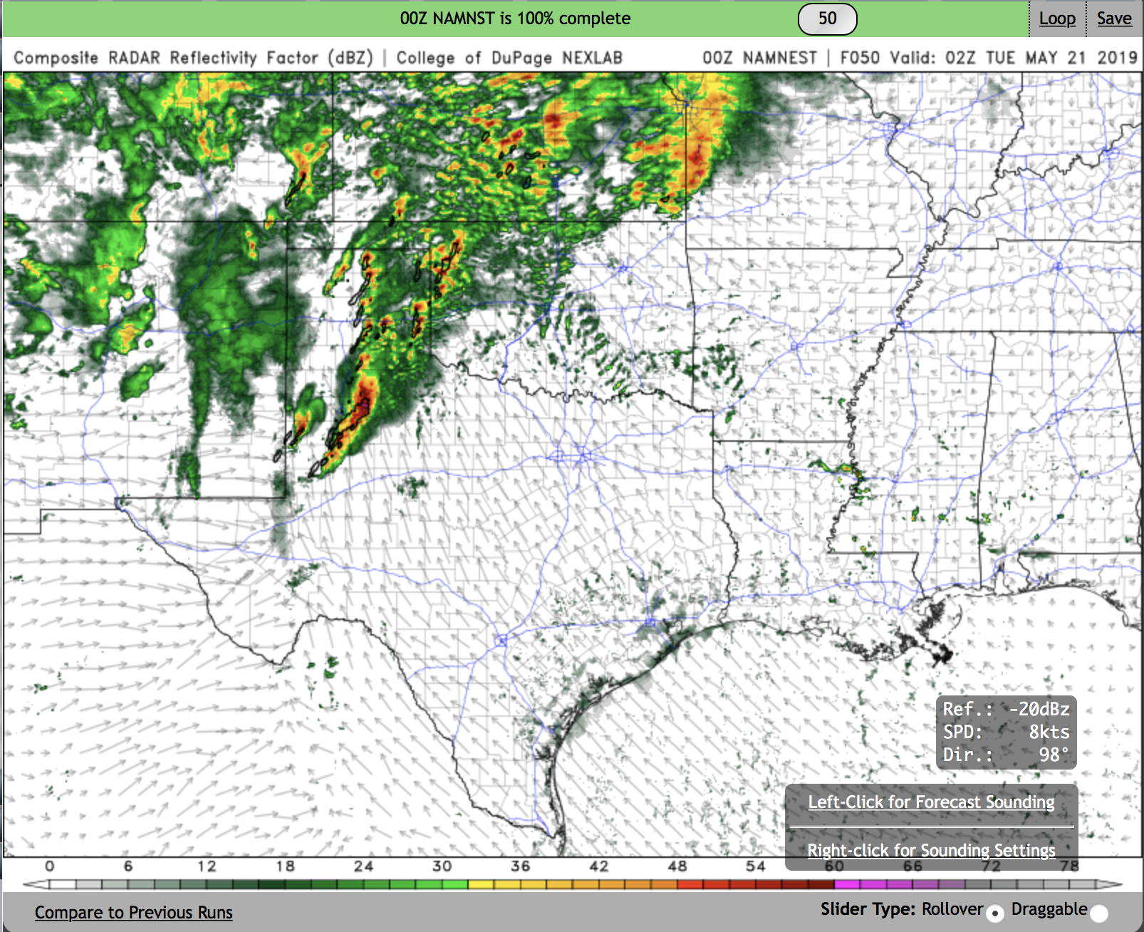
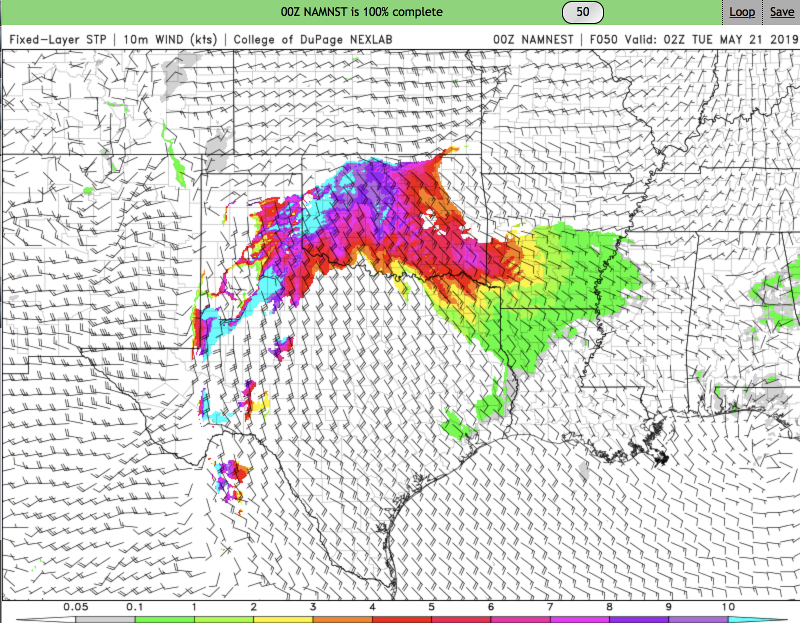
00 UTC NAM NEST shows a tornado outbreak, albeit a brief one. CI is between 22-00 UTC, and then upscale growth pretty quickly follows by 3-4 UTC.
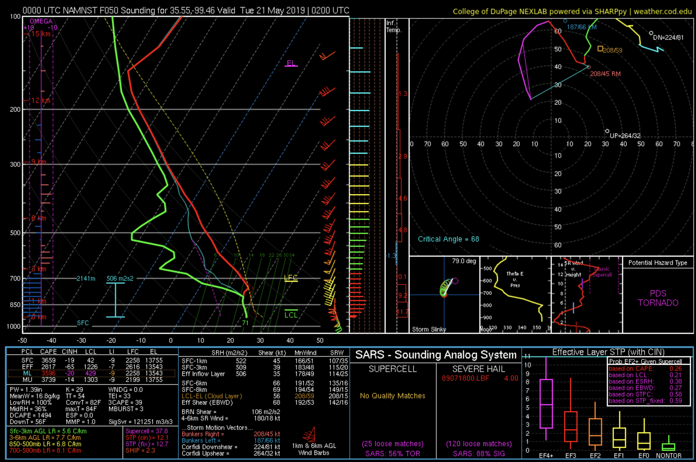
Simulated radar shows numerous discrete cells with high UH at 02 UTC. Widespread STP > 10 in the region where cells initiate. I attached two forecast soundings: one in OK near the northern discrete cells and one in the TX panhandle near the southern group of cells. Both profiles are, needless to say, impressive.
I'm still curious about the deep low-level saturated layer shown in the NAM and NAM nest. This may be a result of strong low-level ascent associate with warm air advection earlier in the day, though warm air advection ramps down into the afternoon. This same feature was present in soundings from the 4-13 event, which turned into widespread messy/grungy convection in the MOD risk region. Really, the feasible only bust scenario is widespread junk and/or upscale growth that happens too quickly. I wouldn't discount this scenario, and it's certainly enough to hold back a day 2 High risk. That sort of call really needs close to 0 uncertainty in day 1, and I don't think we're anywhere close to 0 uncertainty right now.
If we do manage to get discrete cells, they are going to produce numerous ground wedges and ground scraping mesos, in the style of gulf mega outbreaks.


In my honest opinion, what sets this apart from the 4/13 "bust" is a prominent focus for surface-based convective initiation: the dry line. If you had a surging dry line into eastern TX with favorable shear orientation, I imagine that day plays out much differently.
Instead we didn't exactly have that and storms were initiating but not exactly well-rooted into the surface, nor organized. I think that is a key difference, and the CAMs across the board are depicting varying solutions that all kind of converge on a mixed-mode severe weather outbreak by/after 00z. Agree that a day 2 high is too much. But don't think a day one high is out of the question yet.
Threat for supercells producing significant or violent tornadoes should carry well into dark with the strong theta e advection. Boundary layer stabilization should be offset some.
-
19 minutes ago, nrgjeff said:
Glad nobody started a thread. Today does not deserve one. My first day back since Sunday..
HRRR seems odd with heavy stratoform precip. NAM tries to fire off the back side of line later this evening. LOL at that solution with LLJ cut off and stable atmo.
Line may spit out some straight wind later this afternoon; then, weakens. South Bama could keep going. Spann may have a long night.
Up here I'm not too concerned. Looking fwd to watching more NBA playoffs.
Any thoughts on May from a seasonal perspective? GWO looking increasingly favorable for mid-late May but from this range tough to make any definitive statements
-
Moisture return still looks shaky at best but the GFS convects for Thursday with reasonable temp profiles to sustain surface-based convection... With pretty strong shear profiles in W/NW OK. Additionally while the operational euro does not convect along the dry line, quite a few members of its ensemble do. It's worth watching... The euro also slows quite a bit (the operational member) with an ejection at like 12z Friday. If the wave slows another 12 hours or so, a pretty big Friday event would be on the table (details still needing sorted however).
-
2
-
-
Excitement is understandable WRT midweek system, but I'm gonna argue that expectation should definitely be quite low. The biggest reason I say this is due to the degree of forcing we'll likely see. Both Euro and GFS (up until this morning's GFS) blow up an insta-MCS/QLCS.. This makes sense given the sheer degree of forcing we will see.
A supercell event can still happen, but it would require a few changes to the progs. Lots of changes will happen as there are a *number* of interactions yet to play out with this particular shortwave, including phasing interactions, that are evident looking into the Pacific.
-
1
-
-
I disagree. This is looking increasingly like a long-duration supercell event across the states of Louisiana, Arkansas, Mississippi, Alabama, and Tennessee. Very well put together system we are dealing with here, with rapid destabilization ahead of the front likely. Storms will be able to keep pace, too.
These are some of the largest non-contaminated hodographs I’ve seen for quite some time. I’ll also note the instability progged by all models is looking like an underforecast, at least for southern areas.
-
1
-
-
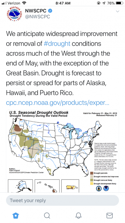
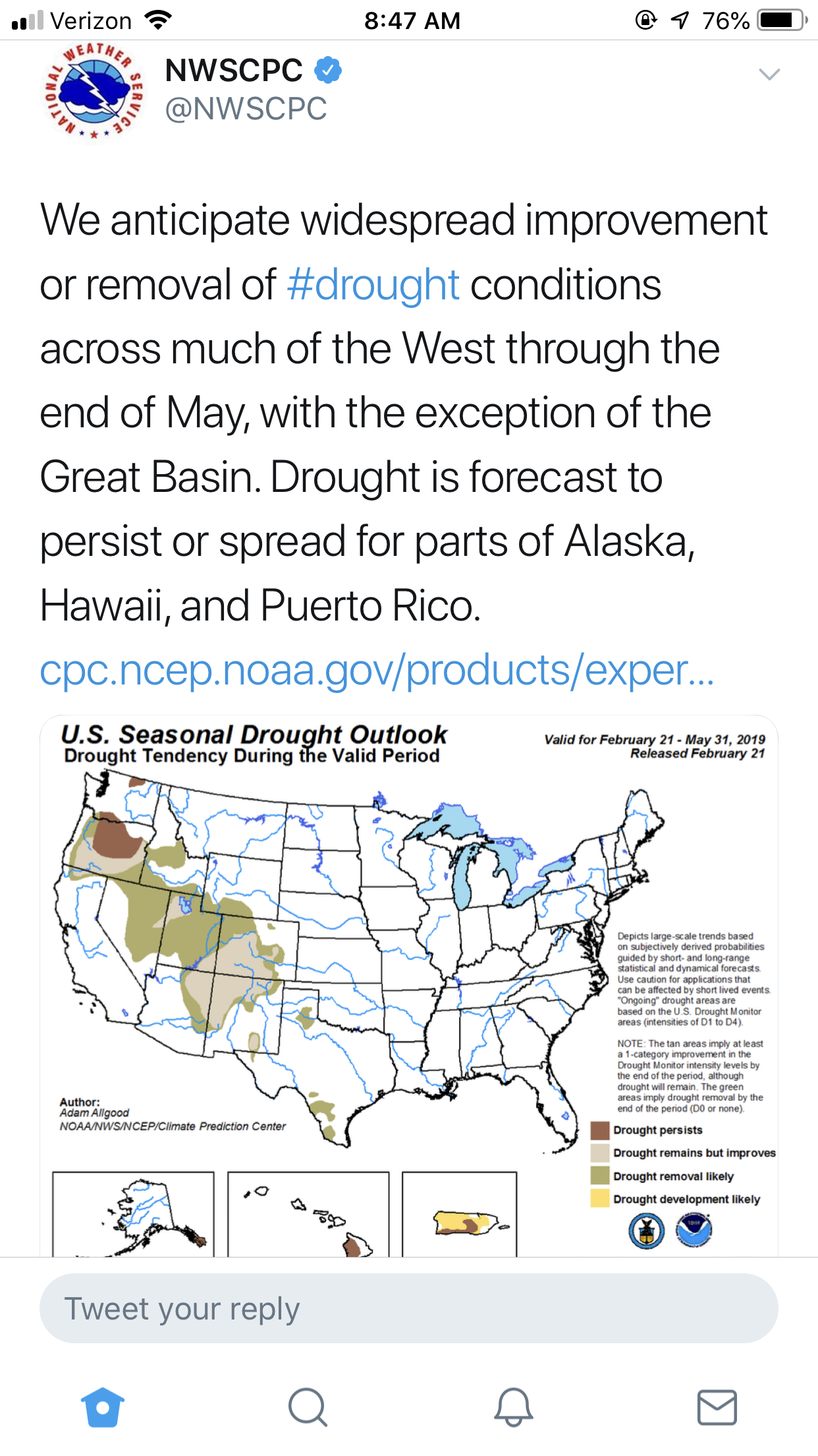
Not terribly surprising but drought removal through May is expected through all of the Plains and much of the EML source region. I’m not sure if this will translate to a fun spring but I’d say buckle up, we could be in for a fun season.
When was the last season where we were relatively drought free heading *into* the season? 2010? 2016?
-
1
-
-
On 2/16/2019 at 5:59 PM, BrandonC_TX said:
I was noticing that on the model runs as well. What are the probabilities that north-central and NE TX gets involved here? (though it's probably a bit early to say) Today's 12z and 18z GFS runs are at least hinting at the idea (though somewhat earlier in the day), but that is just two runs of the same model. The potential event is still over a week out so the models will definitely become more refined as it draws closer, and perhaps more questions can be answered then.
SPC just put out a day 6 for the event, mentioning tornadoes and damaging winds.
I wouldn’t be surprised if we saw a little bit of a Wwd shift but I don’t think this will be all that chaseable regardless. Should be pretty messy.. but definitely has some decent severe potential.
The other region forum has not a peep about it lol. The winter wx weenies, I tell ya.
-
 1
1
-
-
Definitely increasing potential somewhere in the LA/AR and points east area for organized severe weather. Looking like a robust wave will interact with instability as significant cyclogenesis takes place. Shall keep an eye out on this one.
-
4
-
-
This one won’t garner a ton of interest anytime soon but I’m becoming intrigued of a robust severe weather event happening across Louisiana into states to its east next weekend. General pattern progression favors the increase of low level moisture with decent instability on tap by Saturday next week. A significant wave looks to take on a neutral-negative tilt as it ejects into the Plains, inducing substantial cyclogenesis as a result. Won’t really go into more details.. but this one looks to target my forecast/WWA AOR, so I’m a bit peeped for that.
-
1
-
-
5 hours ago, andyhb said:
I will say that I’m willing to try my luck with an El Niño (contrary to Gensini’s tweet) given 2017 and 2018 were both Ninas and generally didn’t yield much chasing wise. 2015/2016 on the other hand...
Ha, I asked him to support the claim that this year could be dreadfully bad, and I got nothing. *shrug*.
I concur... if 2015 had more of the EML we have seen lately, that is an all-time great chasing season.
-
Contrary to what I’m seeing from seasonal/subseasonal forecasters such as Victor Gensini and Alex Gold... I’m skeptical to assume this year will be below average (or plainly bad). I see many folks assuming it’s gonna be a rough year, but I’m super skeptical of where we are in the state of forecasting long term.
Im gonna guess -yes guess because that’s all we really do in this realm of meteorology - that we see an average year counts wise, but I think a good amount of that activity should feature the Plains, making for an AA chaser year.
Reasons: this is the first winter I can recall recently of consistent PAC NW systems and the repeated swinging south of the storm track has kept us relatively drought free in the Plains, and the EML source region getting relief is a welcome sign as well. This is the most promising winter pattern I’ve seen in a long time.
How much does that impact our spring severe? No idea - but it definitely helps to have soil moisture on our side, as it should alleviate intense mixing that can happen otherwise.
As for the base state of the atmosphere, we shall see. I’m a little encouraged by what I’m seeing but.. I also remain curious about what, if any, correlation there is between our changing climate and the severe seasons we’ve seen post-2010/2011. Our record size is just too small to make any firm claims, anything else is guesswork or scientifically speculative at best, and that applies to research trying to correlate tornado occurrences with ENSO and other relatively small-sample oscillations. So I remain skeptical of the claims this year will suck and frankly don’t see much of an argument either direction. I think it remains to be seen just what we get, but we should have a better idea by mid March.
If we could get a 2015/16 style year, I’d be stoked.
-
2
-


Mid to Late May 2019 Severe Threats
in Central/Western States
Posted
Yesterday was the most difficult, successful and ultimately rewarding forecast/nowcast ive ever made while chasing.
We woke up in Dighton, KS. Original target was Syracuse to hedge between W KS and N TX PH. Ended up favoring the panhandle and committed to it at 18z. Problem was N if I-40 was getting rocked and stabilized by elevated junk. So - again at 18z - we committed to roughly Lubbock. This was like a 4.5 hour drive, definitely pushing it. But RAP profiles had us confident it would pay off, given favorable multi-CAM ensemble/deterministic trends and observational/satellite data. About an hour from Amarillo it was evident it would be tough as it was very stable looking. We saw CI imminent as large scale ascent (LSA) - evidenced by increasing coverage and depth of Cu behind the dry line - began to spread towards the dry like. The configuration of the ascent was quite linear and favored rapid upscale growth.
We abandoned the NE New Mexico target because of convective coverage and terrain, even missing a few tornadoes due to it near Clayton. Farther south, deep into the 2% tornado risk and severe watch, we noticed CI attempts ahead of the linear LSA. The first few were not very robust. However the subsequent attempt did it and a sustained updraft was born. Slowly, it matured and eventually began a right deviant motion.
Behind it renewed updraft development occurred but nothing could sustain. Its right deviant motion meant that it would remain discrete, even as LLJ kicked on towards the evening. A classic Great Plains tornadic supercell looked to be developing.
We arrived on scene at roughly 2345 Z I think. A persistent, identifiable cone lowering was evident behind a rain curtain. Could’ve been a tornado, I don’t remember. At some point the storm began to reorganize and a landspout appeared, with swirling dust beneath it. Confirmed tornado warning was issued. Whatever.
As low level flow began to increase, winds backed from SSEly to ESEly, possibly a response to the storm scale pressure falls owing to rotation in the low level mesocyclone. This supercell was extremely organized, with pretty stunning structure to go with it. It was obvious, however, it was encountering a bit of inhibition and RAP profiles suggest the same.
I had thought tornado potential was all but over at this point. Out of nowhere, a ragged, well defined wall cloud showed up behind it. Indeed a new supercell had just blown up in supercell #1’s tracks! Even as this occurred and the first cell was dying, a weak funnel/possible tornado developed.
The rotation on the new cell very rapidly strengthened, perhaps aided by storm 1’s outflow. The mesocyclone rapidly expanded in size and it was obvious this storm meant business.
The wall cloud increased in rotational velocities, some of the fastest I had ever seen. Little ribbons of vorticity began to fill in/touch the ground. A rather large tornado was about to develop, it seemed. And then it happened - a tornado was born.
This all culminated in one of my best iPhone shots I’ve ever had, lol. Unfortunately didn’t have the camera on me. Long story. But anyway, what a day. The many adjustments and the fact we had so much stacked against us - but just enough confidence to say “we can get this done” made this the most enjoyable, satisfying and rewarding chases I’ve ever had. Like 5 chasers were out there with us. This day will be hard to top.