

eddygeeme
-
Posts
39 -
Joined
-
Last visited
Content Type
Profiles
Blogs
Forums
American Weather
Media Demo
Store
Gallery
Posts posted by eddygeeme
-
-
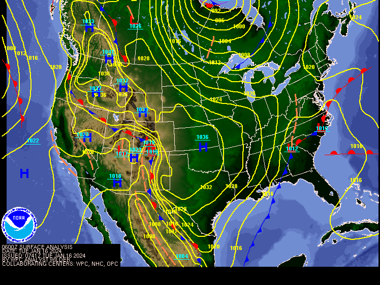
996mb Low off the coast appears to be in no hurry to move out. It's moved back to the coast. Top pic is current placement.
.gif.9d40ecafb3ba35bd8926d53e93f26881.gif)
.gif.4606c9c75449f8b730c9225de60b54b0.gif)
-
 3
3
-
 1
1
-
-
-
48 minutes ago, Terpeast said:
7” here
A little over 8 of exit 16 (Milestone) Germantown/Clarksburg
-
1000mb LP centered just onshore Southern Outer Banks let's see if it can strengthen should head NE til about the VA Cape than ENE looking at the isobars
.gif.c0dab5a725e57b728fe52c8dc9e2c25d.gif)
-
2
-
-
-
9 minutes ago, Imgoinhungry said:
Crazy how stationary that band has been
.It is has maybe moved 2-3mi north or South but just a constant jet streak. The upper level dynamics around that have got to be interesting.
-
27 minutes ago, Imgoinhungry said:
Anyone in Germantown. That band has seemingly been over the area for 2 hours now.
.I am I'm eyeballing 7-8
-
1
-
-
17 minutes ago, SnowenOutThere said:
Looks like it’ll be between bands again for Reston. Hope all of those up north can makeup for their relative miss this morning.

Germantown has made out great this band is bonus snow lol
-
1 hour ago, Eskimo Joe said:
Legit dendrites in NW Montgomery County near Hyattstown per DOT cameras.
Not far away in Germantown/Clarksburg border right on exit 16 Ridge Rd.
-
1 hour ago, winter_warlock said:
That's what I got
Same
-
Here's our SLP its on the move slowly gaining strength it should ride the frontal boundary up the coast. Probably keep a eye on how much it can strengthen in regards to how much back filling. Models hinting that's a possibility which is why you've had some push out when this leaves the area. But it's not even to the outer banks yet.
Get some sleep set your alarms for 7 and see where we're at maybe a surprise or two.
-
2
-
-
5 minutes ago, Ruin said:
looks like the back end is moving in faster then forecasted? unless we get some back end filling in thought it was supposed to go until 10am
LP is still onshore down in SC/NC West of Wilmington. Back filling would come from that as it passes by. What you see is just a dry slot or a lull.
-
-
Where is the surface low right now?
-
5 minutes ago, AtlanticWx said:
measurements between 5.2-5.5" somehow in germantown? did not expect this whatsoever lmfao
Can confirm in Germantown as well.
-
Any one have a good map of the low pressure system
-
22 minutes ago, Ellinwood said:
Started as a rain/sleet mix in Germantown, but we're over to all snow as of 5-10 minutes ago. Still light rates.
Yup light snow over by exit 16 Milestone
-
3
-
-
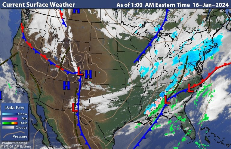
And with this break in cloud coverage temp has dropped a degree from 28 to 27
-
If you're in a area from Frederick to about NW DC look outside if you have a clear view the skies have cleared and the star are out this will be the last chance we get in the next hour or so for temps to drop
-
1 hour ago, pazzo83 said:
Stuck at 33.5 to 34 here. Without CAA, we don't cool off much past 9pm.
What your DP and location
-
1 hour ago, Terpeast said:
Most are in 20s already. Last run had us in low 30s at this time
Said it earlier that's one thing we would need was for temps to get in deep into the 20s as they could. We got that before the thicker cloud coverage rolled in. So we banked our colder temps in. Hopefully we can manage steady temps or a slow rise of a cpl degrees from til morning. Have the cloud coverage be our friend in the early morning at sunrise until the precip arrives late morning.
-
1 hour ago, Terpeast said:
Bottomed out at 27, rose back up to 28.8.
dewpoint 22
clouds probably rolled overhead
Same 26 here up to 28 however peeped outside and noticed some stars peeking thru the high clouds. Looks like there is about a hour break in cloud coverage https://www.star.nesdis.noaa.gov/GOES/sector_band.php?sat=G16§or=ne&band=GEOCOLOR&length=12&refresh=true before the deeper cloud coverage rolls in. Maybe we knock another degree or 2 off the temp and dewpoints.
-
27/20 Germantown/Clarksburg line off exit 16.
-
3 hours ago, clskinsfan said:
37/18. High of 38 today. Dew point has already started falling from a high of 21. RGEM is either the most consistent model of all time. Or it is going to go down in flames thinking it is. Feel pretty confident that my 3+ inch snowstorm drought will end tomorrow. And that is fine by me. Would I like to actually get 8? Of course. But I will enjoy whatever I get.
What's your location?
.gif.ec452ed5eb4d0e70f5231f0178a0a2b9.gif)
.gif.ab0c677336b57fa8fb59e743baf54875.gif)


January 5-6 Thing Storm Obs
in Mid Atlantic
Posted
Hasn't been that long Winter 19/21/22. This might be the first truly wide spread 6+ inches though.