

Normandy Ho
-
Posts
3,187 -
Joined
-
Last visited
Content Type
Profiles
Blogs
Forums
American Weather
Media Demo
Store
Gallery
Posts posted by Normandy Ho
-
-
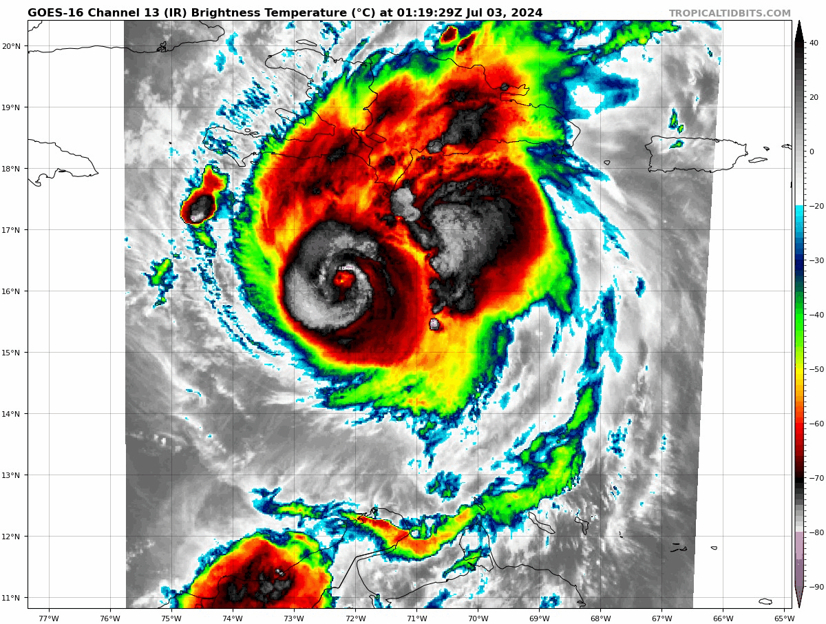
Yep was gonna say those mountains definitely did something because the core looks savage right now on radar and IR. Started happening right as it approached the island
-
People who are saying this is weakening must not understand what they are looking at. I get that shear was suppose to upend this but we have to look at what’s happening in real time. It ain’t weakening. Now admittedly it ain’t pretty, has a very odd structure but it’s obviously still very intense
-
Usually when you see this signature, ten hours later you have a 180 mph monster. Wild wild storm

-
 6
6
-
-
I’ve seen enough. The TUTT isn’t shredding this thing. The major shear axis has already been pushed to over and just west of Jamaica. All the TUTT did apparently was piss it off. Best we can hope for is steady state from now and a miss south of jamaica
-
4
-
-
This is perfect timing for recon. Monster convective burst commencing
-
I digress as this is a beryl discussion and perhaps a separate thread can be made for building code construction, but cost of living in California isn’t actually related to our building codes being stringent. It does impact cost of construction, but land values are high because of the weather in Cali (and proximity to all types of natural forms entertainment like beach, snow, mountains, etc.
-
10 minutes ago, Windspeed said:
This ERC isn't going as smoothly as the first. Atmospheric conditons likely aren't what they were before with the TUTT in place. Still, the new eyewall should take over eventually, and the core is still outside of the strong axis of shear. Beryl should still be a major hurricane as it approaches Jamaica. Still, some questions remain on if the TUTT can get pinched off and where exactly the ULL develops with regards to shear in the NW Caribbean.
RE: Building codes. Most structures in the Windwards are made to withstand high winds. Generations of folks that aren't strangers to high wind events, most of which aren't due to hurricanes, but strong trade winds by the occasional stout low level easterly jet, beyond just an easterly storm or tropical disturbance. They don't have to necessarily be under threat of a hurricane to have gusty 30-60 mph days. That kind of weather is much less common along the GOM coastline unless there actually is a tropical cyclone. Unfortunately, it's a situation of economic factors and poor demographics versus the low frequency of high wind events, even if you live near the GOM coastline, that has led to years of bad building practices. Not everyone can afford a hurricane house, much less afford to live in a well-built house at all, hence all the mobile home parks and cheap flats that plague our residential infrastructure.Well the why we are in this situation is complicated and is more to do with how we are set up as a society. But at a holistic level poorer countries having better building construction in vulnerable areas than a world “superpower” is unacceptable. And this low frequency of wind events I don’t buy as a reason / justification. Hurricanes have demolished communities for decades upon decades and this country refuses to change building codes to match the situation. Same shit with tornado alley. The only place we have even remotely modified building codes to mitigate disaster is in seismic zones. After north ridge and and the Frisco quake of 1989 Cali codes were incredibly revamped, and nobody complained about costs because it had to be done to protect the life and safety of the people living in these buildings. This even caused mass retrofitting of existing buildings to make them safer (and again nobody complained about costs, and if they did I’d didn’t matter because it became the law) That level of detail and action does not occur in hurricane prone zones, even in Florida.
-
3
-
-
To add more to the construction/ damage convo (which interests me since I’m an architect and love seeing how our structures perform against the big bad wolves). I cannot imagine how terrifying it must have been for people In These houses….hiding in a corner under a mattress while the wind just plows through the inside of your house, sucking out all things from inside since the roof is gone. scary scary shit.
the fact that there are not hundreds of people dead is a damn testament to these islands and how they build. The United States of improper building codes should fucking take notice. Make all gulf coast states design to the same code as California seismic code (which is equivalent to designing for a cat 5 more or less without getting too much into the weeds). Just watch when one of these monsters comes ashore in the US, going to be really ugly.
-
5
-
-
I still think we get 2-4 NS in July. I dont think there is going to be an unfavorable period in this season, just varying degrees of favorability. If we are getting a cat 5 damn near in June this season is trying to tell us something (nevermind the cat five developed under less than ideal conditions to begin with)
-
 1
1
-
-
20 minutes ago, NorthHillsWx said:
Absolute utter devastation. This looks more like tornado damage. Just wow
Shout out to those concrete exterior walls that undoubtedly saved hundreds of lives yesterday. United States wood framed construction would have been flattened by these winds
-
3
-
-
That’s impressive damage. Those tiny islands have more resistant structures than our coastal communities do in the US
-
Watch the area around the coast of the southern DR / Haiti this morning. This is where the shear zone / TUTT is currently. The circulation of beryl is going to start interacting with this feature, and I’m guessing intense outer bands fire off on the NW quad. The interaction between giants will be interesting, and im not sold on the TUTT shredding this. Beryl is a really strong feature (not just at lower levels, it has a vicious anticyclone with great poleward outflow)
-
Another MONSTER recon pass. 931 extrap. 154 KT FL winds In NE quad. 141 KT FL in NW quad. Beast mode
-
Recon suggestive of a solid 5 now. I suspect NHC upgrades with special statement
-
The odd structural issues in the east side are because the hurricane is embedded within a strong easterly flow at both low levels and mid levels. This is the graveyard that typically kills most smaller circulations. Beryl is able to keep this flow at bay, however it causes some ugliness on satellite
-
3
-
-
1 hour ago, Ed, snow and hurricane fan said:
I'm trying to see why someone seemed to be yahoo-ing as homes were getting damaged, but at least the homes seem well built, Not well built enough not to prevent major roof damage.
Same reason people screamed when Alex pereira nearly knocked the head off jiri this weekend. People like to see violence sometimes. No need to try and see the why when it comes to this situation
-
1
-
-
Yep changing my tune in this one. One thing I notice different than beryl is this is Already further north and closer to SAL. Not gonna be a beryl repeat.
-
1
-
-
It’s also going to be retired for wrecking the Antilles, Jamaica, Yucatán, and Mexico. This will be a very damaging storm with multiple landfalls. The history it’s already made is merely the cherry on top
-
2
-
-
Absurd deepening occurring right now. Ready for the earliest cat five in record?
-
Starting to cook again. Lucky to have this in radar range to document inner core processes
-
 1
1
-
-
The lightning in the core, insane cloud motions in the eye, and general overall IMPRESSIVE vorticity signature pulling in inflow from hundreds of miles away suggest this is very likely on the cusp of cat 5 intensity. Any intense convective bursts bring it near or at that level.
As has been said by others, impressive doesn’t even begin to describe it. I’m still having a hard time believing it’s happening like THIS this early. Wild.
-
1
-
 1
1
-
-
While beryl is getting the attention and rightfully so, this will also stun people with how intense it gets. Early call is a similar but less intense solution that’s is occurring with beryl, track a bit further north. Major hurricane strike risk for the Antilles is high again with this one (which is just hilarious that I’m saying this and not trolling). Crazy ass season
-
1
-
-
Just wait till tonight when we see the first June cat 5 ever. Special special storm that will be talked about forever
-
1
-
2
-
-
In other words @CurlyHeadBarrett. Shut that ass up it’s game time
-
18
-
 2
2
-
1
-
2024 Atlantic Hurricane Season
in Tropical Headquarters
Posted
What’s funny is beryl isn’t even done. This season could have four or five beryls potentially (long track majors)