
Cleveland_WX
-
Posts
34 -
Joined
-
Last visited
Content Type
Profiles
Blogs
Forums
American Weather
Media Demo
Store
Gallery
Posts posted by Cleveland_WX
-
-
its sleeting and raining at my location the temp just got to 32° and ice is forming on the metal fence
-
3 minutes ago, OHweather said:
Aside from the clipper a week and a half ago, not much has gone great for us this winter (though many sites will finish December near or a bit above average snow for the month, so it's added up some). Was pretty disappointing to watch the models steadily trend farther NW with this system the last few days.
The LES will be interesting. Should initially affect perhaps northern Erie County Monday afternoon/evening before winds come around a bit Monday night and Tuesday, pushing it into extreme NE Ohio. Winds come around to NW over water Tuesday night into Wednesday which should push the convergence south into much more of Cuyahoga and Geauga Counties into Wednesday night before inversions finally lower enough to kill the LES.
I'm not sure bands will be persistent enough in any one area to get totals near what CLE has. Instability will be moderate to extreme through Wednesday evening. Moisture depth and equilibrium heights are OK but not great, however, winds will be fairly weak maximizing residence time over the lake, convergence will be strong near the shore, and BUFKIT shows the best moisture and lift centered in the snow growth zone for much of the event. This combination of parameters will support warning criteria where this band affects over the next few days. Think Erie County will see some 12"+ jackpots where the band persists the most, we'll see if it moves too much for more. Also think there's a good shot that Lake County, northern Geauga County, and parts of Ashtabula County see warning amounts Monday night through Tuesday evening. For Cuyahoga County (and possibly extreme NE Lorain County) and central/southern Geauga County, parameters support a decent band through Wednesday evening...still some time to figure if the and gets that far south, but if it does (which most indications currently suggest) parts of Cuyahoga County may see warning criteria amounts as well...eventually.
I hope! This winter has started off lame. Early out it seems promising but then it all seems to fall apart...
-
Almost at an inch at my house in the west side of Cleveland. Very Christmas-y looking out. Ham is almost done and its snowing. Wish it was more but I'll take what I can get. Merry Christmas everyone!
-
18 minutes ago, OHweather said:
Posting this for posterity. Wow, this is going to be an event places along the western lakeshore into Downtown will reference as a event that's great for that area. Band isn't moving and is intensifying over western Lake Erie. There could be a foot of snow in parts of northern Cuyahoga by morning.
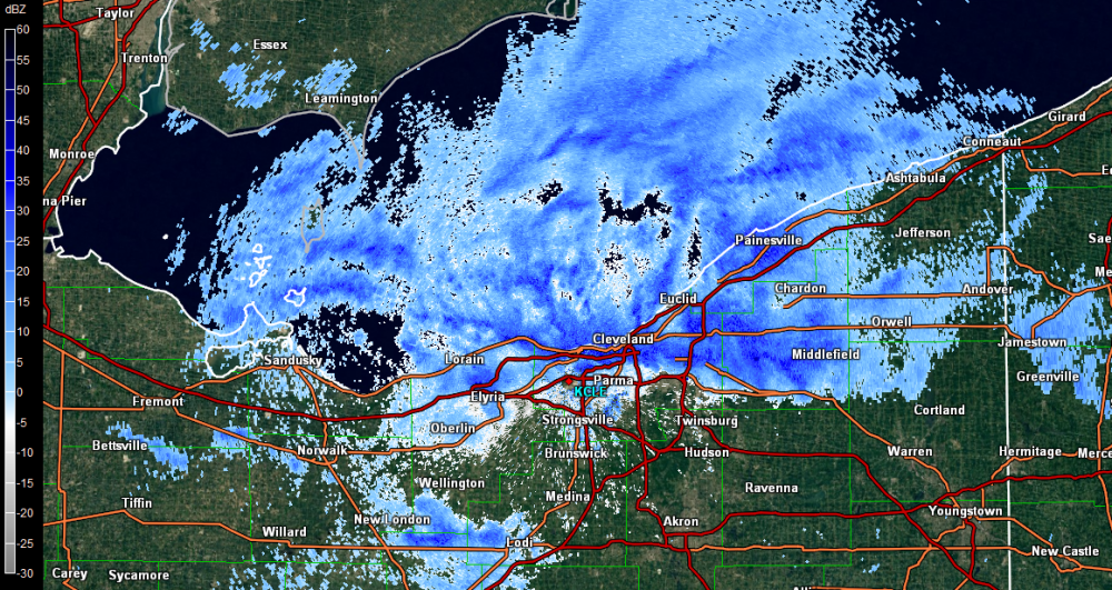
at 10 inches in ohio city. and getting heavier
-
pushing on 4.5 inches here in Ohio City!
-
looks like CLE might get some more. hopefully it bands over the ohio city. fingers crossed!!
-
3 hours ago, OHweather said:
I wasn't home for the band, but there's about 3" here. Again, great call by CLE not including any of Cuyahoga County or the secondary Snowbelt in the advisory. That 2" per hour snow is no big deal, and it won't snow any more overnight into tomorrow.
It looks like just a little wind shift from WSW to W was enough to cause that band to pop...the low levels must be pretty juiced because temps on land were not really much colder than the water temps, so although I'm sure some frictional convergence along the shore was responsible for focusing the band and slowing it down where it did, the lake didn't add a ton of juice to that.
Upslope snow has started increasing in Geagua and Portage Counties with a nice blob southwest of Cleveland as well. The Chardon cam shows pretty decent snow right now. Snow showers from Lake MI have made it to the western basin, which will likely cause snow coverage to increase again by 11pm to midnight in NE OH. Mid-level temps also cool a few more degrees over the next several hours which will increase lake induced instability more. The next shortwave/vort max appears on track for late tonight into early Friday morning, which should again cause an area-wide uptick in snow. There will be a wind shift from W to WNW with that shortwave, which may try to set off another band. We'll see.
Overall the forecast still largely looks on track. The one downfall here is that the lakeshore will continue to largely struggle, but with some Lake Michigan bands making it in and another trough later perhaps they get a bit more.
Agree. NWS in Cleveland is very late with issuing alerts, and weather statements. Why is that?
-
53 minutes ago, NEOH said:
Wow that band is just awesome. I can barely see across the street. Can't ask for a better fetch across the lake. It looks pretty much stationary for now.
Still Blizzard Conditions here. Its piling up!
-
its Crazy!. non stop blizzard for two hours hitting at least 5" in two and a half hours. its awesome!
-
Heavy Band Over Ohio City in Cleveland's west side.. Blizzard conditions!!
-
Snow Showers in Cleveland.
-
I honestly have no clue what more CLE wants before issuing a warning for Cuyahoga. Not only will the eastern part of the county easily exceed warning criteria (if they haven't already) but some of western Cuyahoga will probably push it too. There's a band probably producing 3"+ per hour rates right now bisecting the county and no signs of it moving in the immediate future. I'll say this as nicely as I can but they have no idea what to do with Cuyahoga County. They have completely butchered it three events in a row now.
Yeah we have over 7'' in Ohio City Neighborhood on the West Side of CLE. I noticed when I moved here last two months ago that the NWS is not very good at updating and informing people of what to expect. OHWeather I trust your forecast more than the NWS of Cleveland hahaha
-
Flurries in Cleveland have started.. i hope we get a good band over on the west side of the river..
-
After a nice chunk of my life, here's my best guess verification map for the past event, clipper and LES included:
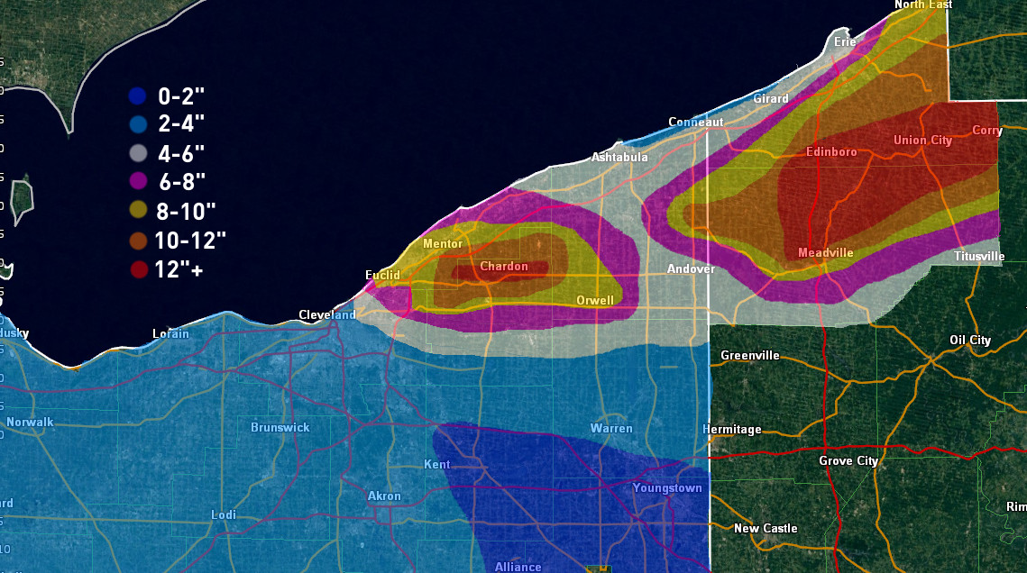
A few notes on the map itself:
-There were few spotter reports in eastern Ashtabula County and western inland Erie County that were "reliable"...I say this because there were a few spotters that called in for parts of the event but didn't for others when I knew they got snow. The only good reports in that area were MAIDEsNow's 14" report from NW Edinboro and a spotter that had a total of 13" just NW of Edinboro as well, along with 11" from a spotter near Pierpont. Radar overshoots LES badly in Ashtabula/Erie/Crawford so unfortunately I had to do a lot of guessing there based on terrain, surrounding reports and what radar happened to picked up there.
-The only good reports in eastern Cuyahoga County and western Geauga County were a total of 8.8" in Euclid from a trained spotter...11" 2.5 miles north of 322 from LakeEffect in Chesterland, and 4" in Newbury/South Russell from dta and NEOH. Luckily radar doesn't overshot LES there so I feel much better about that area, but the lack of reports and sharp cutoff mean I may be a little off. The 8" edge looks jagged in NE Cuyahoga, however, that is supported by radar, as there was a good period where the band absolutely ripped on Euclid but areas immediately southwest weren't getting good snow, and a period of time earlier on in the evening when the band was farther south where heavier returns were consistently just east of 271. It's probably not perfect and a few of you live/work in/drive around in that area, so if that looks off please let me know and I can tweak.
As for the forecast, was a little low on max amounts. The band placement in NE Ohio was pretty good compared to forecast, however what I needed to do was extend heavier amounts much closer to lakeshore. It seems like these firehose bands driven by strong convergence are the one type of event that do well all the way down to the shore, so it's something to keep in mind going forward. That was the biggest thing on my map that I ended up not liking. I did pretty good in Erie County PA but worse in Crawford PA. I'm trying to get better in that area, but I haven't been able to watch events there on radar for years and years because radar overshoots LES there, so it's still a process.
Next event could be interesting, so on to th
Ohio City- Cleveland couple blocks in from the lake-shore there is at least 4 inches on the ground.. Have had a few good bursts come through.
-
Clevelands NWS does not update frequently.
-
ohio city in cleveland four blocks away from the lake and 5 mins from dt
It depends on where in Cleveland you are. Although Cleveland proper certainly sees some lake effect, the heaviest totals often end up east of town out towards I-271. Right now I think this event looks pretty good for that area and would at least bring accumulations to Cleveland. There's still time for things to change though, lake effect is wonderful when all goes right but can be fickle when things start going wrong (IE, too much dry air, wrong wind direction). Anyways, welcome to the area! I'm sure we'll all be posting over the next few days if things keep looking good.
-
So its looking good for cleveland? just moved here and never experience lake effect like this before
Another fantastic GFS run for the Tuesday-Wednesday clipper and lake effect combo. Will be curious to see if this holds, NAM will start getting into range Saturday night. The GFS and probably Friday's 12z Euro too would be significant events for probably Cuyahoga County and definitely parts of the primary Snowbelt. Of course...I leave for Athens Sunday morning

For Cleveland...gonna break out the ol' OHweather hype meter for Tuesday-Wednesday and set it to 6/10 for now.

Northern Ohio Obs/Discussion Part 2
in Lakes/Ohio Valley
Posted
Saw lightning once we converted to snow here in west side of Cleveland. Windy as all get out lost power already hopefully we get some good snow already got a dusting.