

keno19
-
Posts
92 -
Joined
-
Last visited
Content Type
Profiles
Blogs
Forums
American Weather
Media Demo
Store
Gallery
Posts posted by keno19
-
-
Every person on this community is a weenie including myself. lol The workers of the NWS don't come into forums like this. Bernie Rayno probably one of the best experienced meteorologists i know. Todays weather channel meteorologists are all kids. Seems they almost just give atmospheric science degrees now like water. They dummy down the physics and calculus. Its sad everything now is ensembles and looking at models from run to run. I look at 75% of todays news weather men or women and they have backgrounds as journalism, earth science, environmental science lol. Those degrees don't go through the tough math and physics calculus differential equations, multi variable calculus, thermodynamics etc. probably why forecasts are horrible today. Don't want to be negative. I just like the real science behind the forecast.
-
 1
1
-
 1
1
-
-
Nws already dropped the wind advisory. Highest gust 25 mph.
-
south massapequa highest gust 19.9 mph (30 foot pole) as of 7:11pm
-
South Massapequa 0.00 in winds peaked at 36mph
-
models this year have way over performed wind gusts
-
1
-
-
I was let down on the forecast of 2-3 inches of rain and 60 mph gusts. Im here in south Nassau and my highest wind gust was 29.1 mph and rainfall for the event was 0.91 inches. My tempest weather station is 25 feet above the ground nothing blocking the wind. I am trying to figure out if the storm wasn't as powerful in my area or is the tempest weather station not accurate on wind? i know its not accurate for rainfall do to false vibrations from wind. anyone have any suggestions or ideas on this?
-
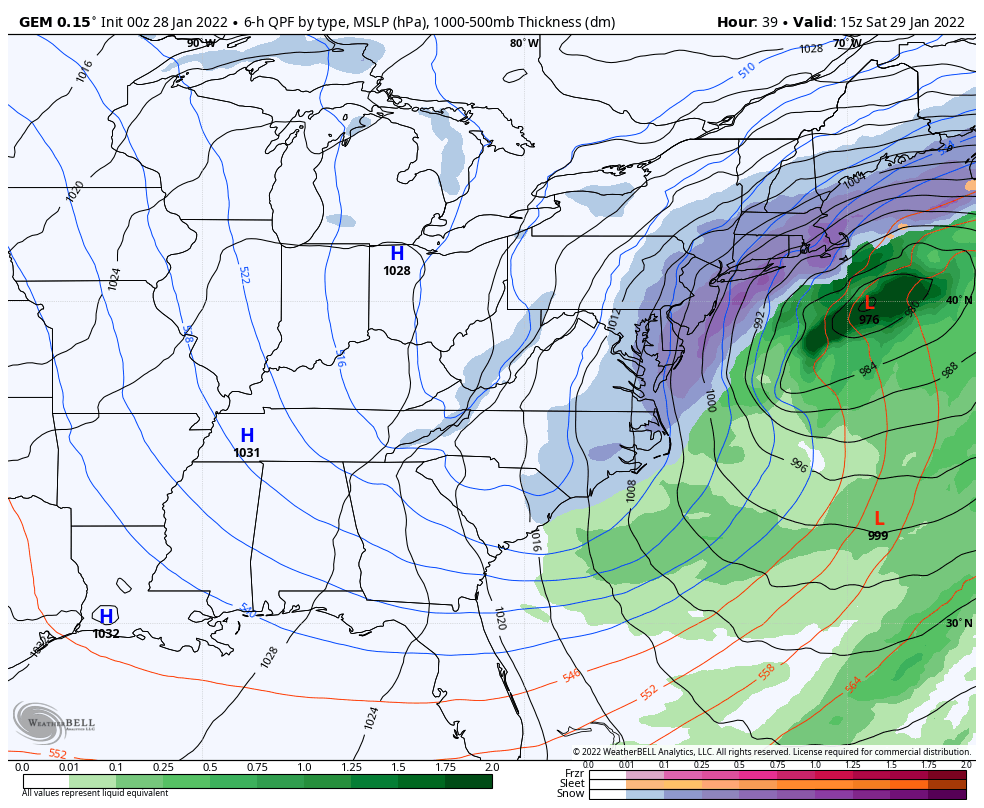
992mb Low deepening. isobars will start to get stacked by 12am across LI
-
3 minutes ago, Brian5671 said:
hard to say how much they'll mix down-last weekend's event was a bust wind wise but a few weeks ago one overperformed with no advisories for anyone and we had gusts to almost 50
i agree i majored in atm science the whole mixing winds down is hard to predict, inversions caps etc. never bullet proof
-
South Massapequa
1.60 in
highest gust 21 mph
waiting lol for wind advisory level forget about high wind warning
-
i am wondering how much of these winds will mix down. I don't believe suffolk county high wind warning will hold.
925 mb winds not as impressive over long island
-
0.97 here south shore Nassau
-
models did not handle this well
-
 2
2
-
-
im calm just tired of the hype on tv 2-3 inches. even if some yellow echoes come through just not going to be anywhere forecasted. 0.5 in to 1.5 in would have been a better forecast on long island. typical fall weekend rain
-
 1
1
-
 4
4
-
-
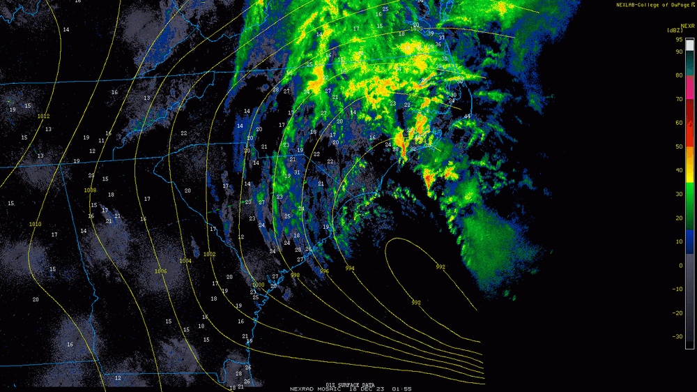
0.05 inches what a joke. all the current radar images lost the yellow. lucky to get .50 inches out of this on long island.
-
1
-
6
-
-
On 9/10/2023 at 7:47 PM, Sportybx said:
What would cause the Hurricane hunters not being able to fly through the eye wall last night , saying it was too dangerous?!?
Because its expensive. jet fuel, dropsones and paying OT for a storm that has weakened alot. Also its wasting time now. The storm is becoming extra tropical. No need to waste time anymore but the media and NWS will never say that. This will be a tropical storm in the next 6 to 12 hours. Basically becoming a noreaster. The overhype is starting because of all the attention and money put into this 1 storm as it dies out.
-
1
-
-
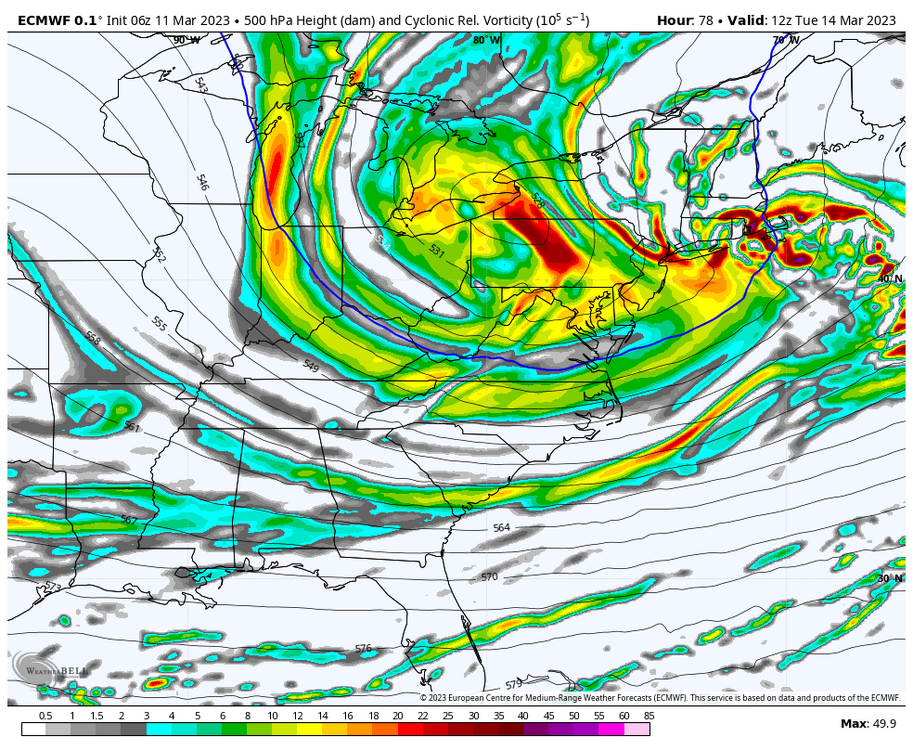
I hate to disappoint many but long island will be getting rain. With temps 45-50 warm ground in place. No arctic air in place, stronger March sun angle. 500mb upper energy too far north. Dynamic must be perfect and intense . Too much against. Also watch as storm starts the bulk of the qpf will be rain so watch
-
6
-
-
too far north
.thumb.png.5559407273e4094b4d12d513be45da84.png)
-
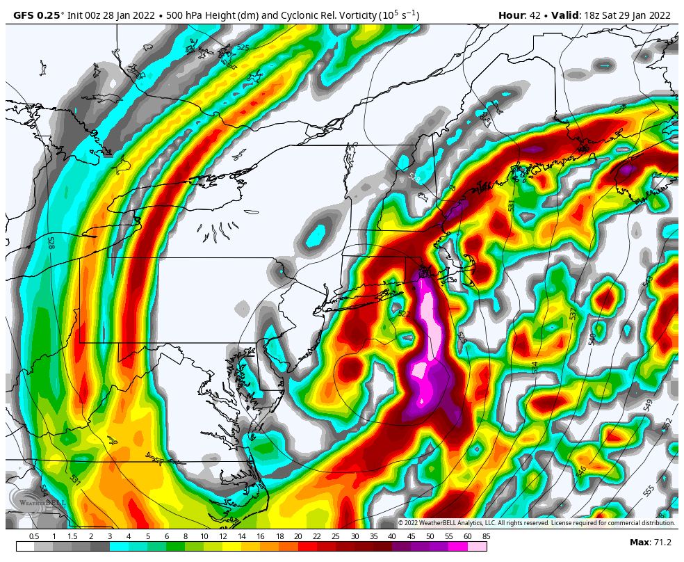
This is what we need to watch where the energy moves. Not surface
-
And here comes the dry slot for long Island lol
-
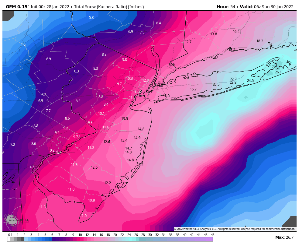
Long island still no frozen precip. All models did not time this correctly. Event almost over
-
-
-
-
closed upper low bingo

-
2
-

.png.a3c96c92f1f6758192f61c831b4cbd5a.png)


2/13 Significant/Major Winter Storm Discussion & Observations
in New York City Metro
Posted
Yes I didn't mean to insult anyone on here or any of the meteorologists on this forum. Had to clarify.