

Dino
-
Posts
502 -
Joined
-
Last visited
Content Type
Profiles
Blogs
Forums
American Weather
Media Demo
Store
Gallery
Posts posted by Dino
-
-
Just now, PivotPoint said:
You’re right it is. Just searching for any trend. But yea a litt close in
The north trend noted in forecast discussion:
Perhaps the most notable and significant feature affecting the
upcoming system is a compact shortwave diving southeast from the
Hudson Bay vicinity. This shortwave is rotating around a larger
cyclonic gyre centered over southeastern Canada near 60 W. This
upper pattern has acted to enhance confluence over northern New
England southward toward the Mid-Atlantic, which is resulting
in the more west to east low track out to sea to our south.
However, this shortwave feature to the north has appeared to
deepen a bit more than forecast over the last 12-24 hours,
resulting in subsequent subtle downstream height rises. It`s
not much, but it appears it may be just enough to weaken the
confluence near and to our north a touch, allowing a northward
shift in the tight northern edge of the snowfall from low
pressure passing to our south.

As such, 12z guidance has unanimously shifted northward. Mean
QPF from model output has risen to nearly an inch at the
southern most reaches of our CWA (southern Nelson County), and
just under a half inch near CHO. The northern edge of
accumulating snow remains a challenge, but there is a non-
zero/increasing chance for flurries or a light coating of snow
as far north as I-66/US-50, in line with the northern edge of a
baroclinic leaf developing upstream on satellite (marking the
northern edge of stronger synoptic upward motion).
-
 1
1
-
-
CMC pushes north, Euro trending north, HRDRPS is north, RGEM is north. Dang, even the GFS has been shifting north since 0z
Euro is catching on to dynamics better -- Seriously think this will pivot -- snow up through Baltimore and possibly Philly.
HOT sea surface temps off the coast...looking good
.thumb.jpg.a23b6e01ab6212d1729097e508f9a17c.jpg)
-
1
-
-
Every winter same thing. Suppressed to the south now, then soon we will be worrying that it will pass way north of us.
I say lock it in - 10" from Richmond to NYC.

-
2
-
 2
2
-
-
FV3-GFS is close to a One-Two-Punch scenario along mid-atlantic and northeast November 29th & Dec 2nd.
-
2
-
-
3 minutes ago, Snow88 said:
DT is talking about 2 possible snowstorms in the east
One at the end of this month and the other one in early December.
Right now the tellies look awesome if you are a snow and cold lover.
Exciting - we started the winter off fantastically - the December 2nd Storm looks VERY interesting. The Arctic Oscillation index straight up plunges almost off the chart end of November and pops back up Dec -- looks extreme.
.thumb.jpg.6c2188ba3c18c11702c9a4c1a969bc45.jpg)
-
10 minutes ago, David-LI said:
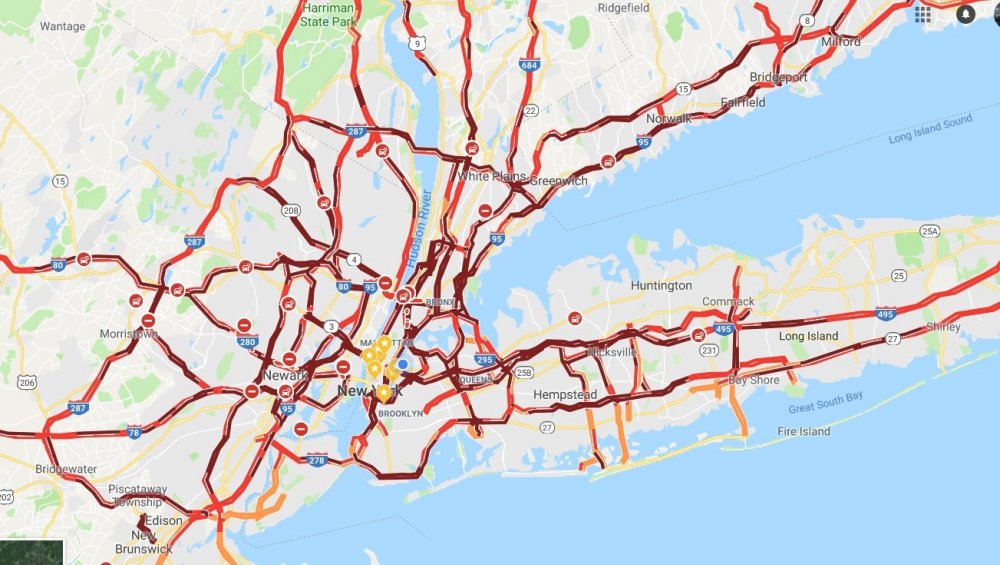
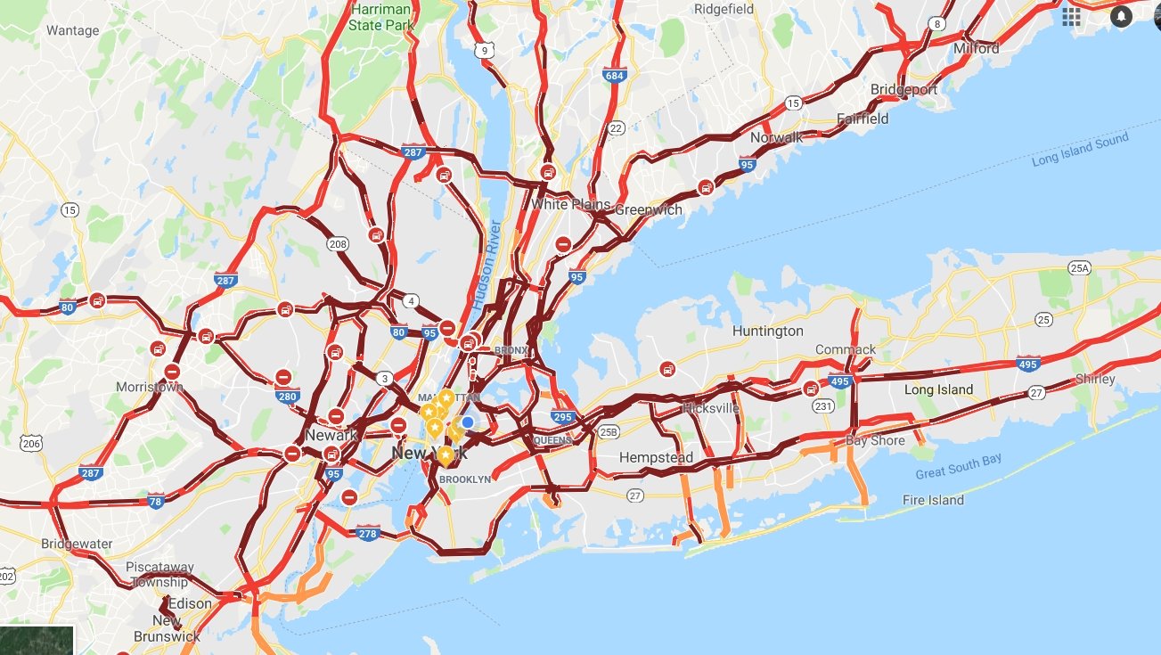
Wow what a mess! We shall never make fun of Atlanta ever again when they get snow.
I know right! Atlanta is gonna have a field day with this news tomorrow. I can’t believe what I’m seeing - just search NYC Traffic on twitter and look at the insanity. The morning news tomorrow is going to be wild.
-
Unreal —over 1000 reports of trees down or damaged across NYC
https://twitter.com/nycspeakercojo/status/1063271539813031936?s=21
https://twitter.com/samuelhartson/status/1063246366955188224?s=21
and here’s more gridlock in Manhattan:
https://twitter.com/kendisgibson/status/1063275941277966336?s=21
-
caught this car slide a bit heading onto the queensboro - you see how icy the roads were earlier

-
1
-
-
big mess - just constant sirens in LIC. the queensboro bridge has been backed up since the first flakes started
-
Port Authority shut down the bus terminal
https://nypost.com/2018/11/15/port-authority-bus-terminal-closed-due-to-snowstorm-overcrowding/
-
wow and the temp keeps dropping -- down to 28 now in LIC. Lighter snow moving in now
-
Yikes - so glad i never have to drive on the LIE anymore...
It's pretty obvious nobody prepped roads for this. I'm seeing 1 to 2 hr traffic delays in all directions
-
 1
1
-
-
wow, the snowfall pretty much has stayed the same intensity this whole time. Can't see far outside my window.
Everything is covered, cars having rough time driving around side roads.
The temperature has steadily DROPPED as well. Started at 33 and now down to 29. Hoping to dryslot before the rain comes in.
-
Interesting that the NAM3K, 12K, HRRR, HRDRPS, and all the WRF's showed more than 2" of snow consistently for the area while the GFS and RGEM were showing Trace-to-2" roughly.
-
Upped totals for LIC to 3"-6"
Over performance, hopefully a sign of things to come this winter.
"
Significant update based on latest radar trend snowing hand of
heavier precip developing from DC metro to southern NJ, which
high resolution guidance including the NAM/HRRR/RAP bring into
the area during late afternoon and earlier evening. Despite
easterly flow, temps upstream along the south coast of New
England were in the mid 30s with dewpoints in the lower 20s, so
do not expect too much in the way of maritime moderation at
least into this evening. So the overall trend is for colder and
snowier going into early this evening. NAM may be a bit too
cold in the blyr, but we also started out the day with lower
dewpoints and so greater potential for temps to crash close to
freezing with onset of steady precip this afternoon. Period of
steady snow looks to be heavier and of longer duration than
initially expected, and warmer air aloft does not look to make
it in until about 23Z-00Z around NYC, and to interior sections
til late evening.

With the above in mind, issued winter storm warnings for the
interior where snowfall amounts have been bumped up into the
4-8 inch range, and winter wx advisories have been extended
into NYC and Long Island for 2-5 inch snowfall, with the higher
amounts generally farther away from the immediate coast. Also
bumped up amts along the CT coastline, and the coastal zones
could see some 6-inch amounts north of I-95. Timing of snow in
most places should cause significant disruptions to the
evening commute.

Warm/dry slot should work its way in tonight, with precip
changing over to sleet and then freezing rain. Up to 2 tenths of
an inch ice accretion fcst for portions of the interior. Storm
total snow and ice graphics are posted.

Bl should warm sufficiently along the coasts to limit the fzra
threat there. Should winds there not behave as fcst and back to
the N, perhaps due to the influence of a developing cstl front,
a period of icing would be possible in NYC and portions of wrn
Long Island early this eve.

Wind speeds have been increased in the fcst as well. Speeds of
50 kt were evident blw 2kft in the 00Z NAM. The other modeling
was weaker, so for now a wind advy was not issued. Gusts however
have been increased to 45 mph at the coasts. Peak winds are
tngt, although another burst is possible early Fri as the storm
exits.
"
-
00z GFS playing hard to get.
-
Man it's cold -- Already 33 in LIC.
0z's are gonna be great tonight. Forecast discussion basically puts 1-3" on the coast and 2-4" inland -- I'l take it!
-
Well, it could be worse for the coast. Looks like T to 2" in NYC. By the way, wow did this turn into a big one for inland areas!

-
1
-
-
Definitely FEELS like its going to snow outside. Currently 37 in LIC.
18z RGEM is rolling... looks like T-1" at 25hr
-
1
-
-
the Low pressure has been trending tiny bit stronger -- about 3 to 4mb and the position is staying just offshore - 12z GFS has it just south of LI instead of on the NJ coastline. If it ticks east a bit over the next few runs we should be ok NYC and west.
-
18 minutes ago, NEG NAO said:
The 12Z Euro shows 4 - 8 inches across Northern / Central NJ into NYC on Thursday
https://weather.us/model-charts/euro/new-jersey/snow-depth-in/20181116-0100z.html
12z Euro looks beautiful.
also, seems 18z GFS just made a big correction eastward, heavier snow closer to the city now on the 2nd wave/Friday. something to keep an eye on for sure.
-
Storm thread for Thur/Friday? Snow potential....
-
1
-
-
LIC. 58 degrees. Rain. winds 15 to 18mph. Rain pelting the windows quite hard.
-
The forum has been unusable, un-viewable, and have to force quit my browser on mobile every time just to get the amazon gift card crap to stop showing up. Something has seriously infected the website.
.jpg.66f6c70fc9a76520bbce6706100d67a0.jpg)
.jpg.e756f2c8938e29fb5c480a4d5cf7f87c.jpg)
December 9/10 Storm
in Mid Atlantic
Posted
FWIW, the JMA model also shifted the heavy precip shield north...looks significant
Dusting off these models lol - anyone got the latest Korean model?