

ingyball
-
Posts
66 -
Joined
-
Last visited
Content Type
Profiles
Blogs
Forums
American Weather
Media Demo
Store
Gallery
Posts posted by ingyball
-
-
3 minutes ago, Upper Level LOL said:
UH tracks =\= tornados, that's a pretty crude way to interpret that
Sure, you use it like you'd use any other parameter. If you go blindly using any one parameter you'll get burnt. The important thing to take from it is that the model does have a storm there that could otherwise take advantage of an atmosphere capable of strong tornadoes. Perhaps it's in the form of a QLCS, but it's been stated before that even a QLCS can produce a strong tornado in some of these atmospheric conditions.
-
Atlanta and the western parts of Georgia are under the 10% hatched, perhaps it may be a tad overboard, but they're very much on the eastern edge of the tornado threat for right now.
-
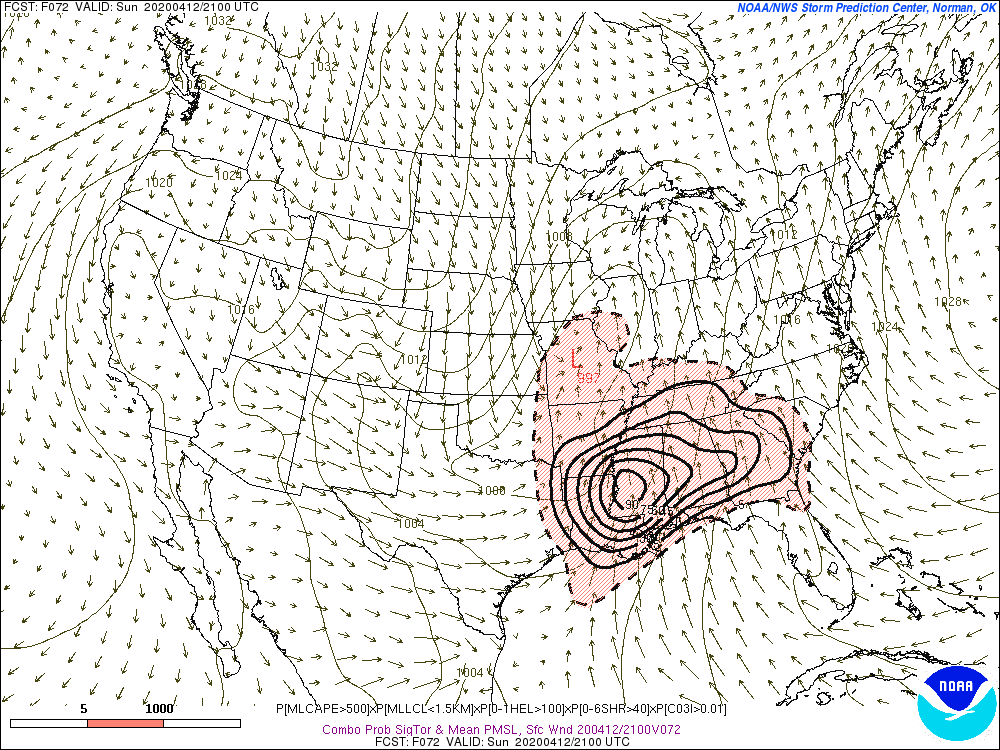
I don't post here often, mostly lurk, but wanted to post the 21z SREF Sigtor probs for 21z on Sunday.
-
That tornado in AR is big Yikes.
Edit: Thankfully it appears the rotation has weakened for the time being.
Edit 2: And it just tightened up again in the last frame
-
I had been feeling like tomorrow was the better tornado threat due to less evident vbv a couple of days ago. Though I still think storm mode will be a problem. The new tornado watch highlights the main concern tonight which is the strong straight line winds. A High chance for at least 1 65kt+ wind report is no joke and should be taken seriously as well.
-
 1
1
-
-
The sun has been peaking out here in SELA a bit, looking at satellite there seem to be spotty breaks all over Louisiana
-
5 minutes ago, Bob's Burgers said:
More interesting observations is the latest NAM3k --> Successfully launches discrete cells in the open warm sector with UH (rooted, possibly tornadic cells) in LA. Several models have been indicating this could happen but this is the best evidence of it happening undisturbed.
The 0z HRRR does something similar just ahead of the main line at hour 35 and 36. I'm hoping it's wrong since I'd be right in the path of those storms, but it's definitely been my concern.
-
5 minutes ago, MUWX said:
Any chance this goes high risk?
I'm not sure there will be enough confidence to pull a high risk, but if they find that instability is higher than predicted and that the meso scale models are predicting more discrete cells or a broken line I could see them at the very least increase the tornado threat and hail threat to moderate and extend it westward to the eastern parts of the Metroplex.
-
1
-
-
36 minutes ago, SmokeEater said:
Usually not good when the MIC of FWD posts this....
Tom Bradshaw @SoonerTom
25s
On 95% of the days in N TX, you can ignore the weather and it doesn’t amount to a hill of beans. Tomorrow falls in that “other special 5%” category. The threat will be real, so PAY ATTENTION. Plan ahead, have a way to get warnings, and know what to do if one’s issued for you.
Sent from my SM-G973U using Tapatalk
It's been a long time since I've posted here, but I know Tom, and that coming from him definitely highlights the potential seriousness of this event at the Fort Worth office.

April 12 Severe Event
in Southeastern States
Posted
A chaser got in and was able to see the damage. Looked almost certainly EF-4 damage there, but I honestly think it could have been an EF-5