

AMDEW80
-
Posts
93 -
Joined
-
Last visited
Content Type
Profiles
Blogs
Forums
American Weather
Media Demo
Store
Gallery
Posts posted by AMDEW80
-
-
6 minutes ago, canderson said:
If you get an sleet bomb we’ll need urban food watches.
hopefully neither happen!
6 minutes ago, pasnownut said:Good luck up there. I'd much rather be at the cabin in Gaines for this one, and not down here. Enjoy and please let us know how you fare.
I'll keep you guys updated tomorrow, hopefully wandering around in the snow tomorrow evening.
-
Nice to see some chat about us up here in Tioga county earlier in the thread...not sure what to think about this storm, hoping we stay mostly snow up here, but this reminds me a little of early winter last year, where we were supposed to get mostly snow and we ended up getting hammered by sleet... we shall see! happy to be tracking again. hope the cold wins out in the LSV. Sitting at 21/18 currently
-
 1
1
-
-
The radar is a beautiful stream of moisture from the gulf. Good luck everyone!
-
1
-
-
nasty outside, moderate mix of sleet and freezing rain sitting at 23. tree's starting to ice up.
-
6 minutes ago, BGM Blizzard said:
Just stepped outside. All freezing rain. Already have a glaze on the pavement. F***kkk!
Just to let you know, down here at the border... started off freezing rain, now flipped to sleet as the heavier stuff moved in... messy
-
Also flipping to sleet here, and coming down pretty good. Still 22 degrees.
-
light freezing drizzle and 22 here.
-
6 minutes ago, Wmsptwx said:
Today kinda turned out very quiet. 27 and bright overcast here.
You are not joking... I’ve been in winter storm warning since 7 am and have a whopping half inch of snow with brightening skies.
-
Wow this non stop nw sprint is getting unreal. Hopefully the late night run stops it. If not this could be a Detroit special and we move on to Thursday looking for white gold and not ice.
-
33 minutes ago, CoralRed said:
I am not making this up: Channel 16 news commercial just said 3 dead over a dispute -- about snow. I cannot believe I just typed this. I wish I heard it wrong.
“This is what happens Larry, this is what happens when you clean somebody’s snow board”
-
 1
1
-
-
2 minutes ago, MAG5035 said:
I've had 1.2" today since I cleared my one board at 9am this morning for a running total of 5.9" so far... in the 33 hrs since this started. Brutal. This has been such a slow event here that my non cleared board is about 5.7" (very little extra compaction).
yea today has been brutal for me as well... sitting watching the snow line 30 miles east of me All day. Hope to get into the action later as the models are showing...but I'm starting to have my doubts. Pumped for everyone else getting in on the action!
-
The radar looks beautiful around the Harrisburg area and east, enjoy. I have been sitting outside the western edge all day. Hopefully will get back into the snow at some point.
-
12 minutes ago, Ruin said:
Yeah Im in that room atm cause its more active I have no idea why people are getting so testy
If you wanted me to guess... it’s day drinking
") imagine day two and three of this event!
imagine day two and three of this event!
-
Was thinking looking at the forecast... what has fallen here and hopefully what is to come, is straight fluff, 25 mph gusts tomorrow into Tuesday could be interesting...in a good way
-
just hit 3 inches with the heaviest snow of the day falling. 21 degrees.
-
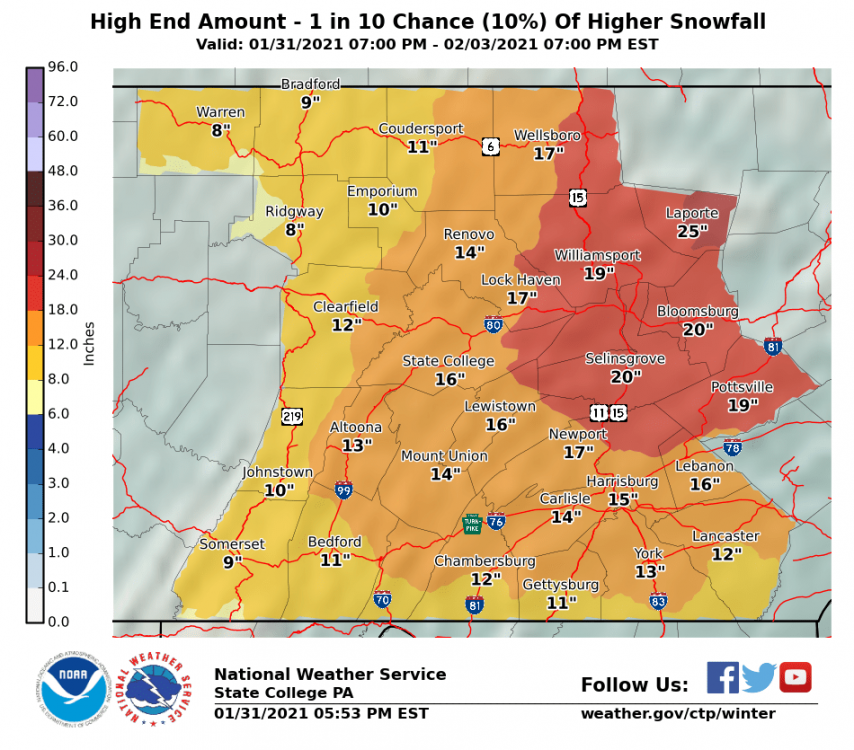
high end is real nice for everyone
-
and for update #42393 of the day from ctp


-
1
-
-
Just got bumped up to a WSW from WWA in Tioga county. Will be interesting to see how this plays out.
-
1
-
-
19 degrees with light snow
Good luck everyone!
-
4 minutes ago, BGM Blizzard said:
Just for you Tim

December storm repeated?!?!
-
11 minutes ago, canderson said:
It’s like someone sent a nuke to Harrisburg
They started 3 mile island back up!
-
1
-
1
-
-
Just when I started to get pulled in...ouch.
-
I ended up with around 27, was an awesome storm up here, especially late night I got the end of that band that slammed Binghamton. The rates were incredible.
Having issues with with the file size of my photos...
-
2
-
-
US National Weather Service State College PA51 seconds ago
Here are the highest reports snowfall totals as of 2AM. Heavy snow continues between I-80 and US-6 in North Central PA. Totals in excess of 2 feet are likely in northern Clinton and northern Lycoming counties where this band has been parked for several hours.
Full list of latest reports: https://nwschat.weather.gov/p.php…
#PAwx
Thursday 12/17 @ 2:15AM


Central PA Winter 2022/2023
in Upstate New York/Pennsylvania
Posted
more than me up here, have at least an inch of sleet and about 2 of snow. We had all sleet with a little zr till about 1 then it switched over to all snow, but the precipitation was lacking. Unless the radar really starts filling in over night this is going to be a pretty big bust on the wsw 6-12 we had this morning.