

Blizz
-
Posts
532 -
Joined
-
Last visited
Content Type
Profiles
Blogs
Forums
American Weather
Media Demo
Store
Gallery
Posts posted by Blizz
-
-
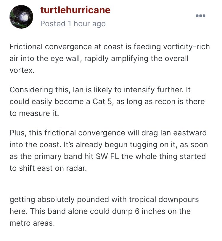
5 minutes ago, turtlehurricane said:
As I stated earlier, I am not surprised. I did my PHD work on this exact thing. Vorticity-rich air from the coastline/land is feeding into the eyewall. The amount of vorticity generated as hurricane winds collide with land is enormous, and this is tilted up in the eyewall, creating super-charged vortical convective towers. Plus all this happened right at DMAX
Thank you sir.
-
 1
1
-
-
Just now, Superstorm93 said:
At a loss for words.
101130 2551N 08312W 7509 02191 9665 +146 +137 013124 129 120 052 00
101200 2551N 08310W 7516 02153 9628 +144 +138 015135 139 126 044 00
101230 2551N 08309W 7521 02107 9592 +147 +142 016136 140 133 046 00
101300 2551N 08307W 7518 02082 9557 +151 +145 022148 160 137 042 00
101330 2551N 08306W 7558 02024 9534 +155 +149 022150 158 137 042 00
101400 2551N 08304W 7573 01993 9516 +160 +155 026143 149 134 037 00
101430 2550N 08303W 7553 02000 9493 +166 +153 027133 143 134 031 00
101500 2550N 08301W 7516 01999 9461 +175 +156 028111 130 131 027 00
Unbelievable.
-
Yeah... not good.
-
1 minute ago, jconsor said:
Great point here by Brian. Though Ian's intensity and track leading up to landfall is very similar to Charley, Ian is much larger than Charley! This will lead to a higher storm surge and much larger area impacted by destructive storm surge and winds.
My family road through Charley in 2004 in Punta Gorda (when they thought it was going to Tampa), they actually were able to go out in the eye... they were spared the storm surge that some feared.
I'm very very concerned this time for the region. No longer have family ties to the area, but it's a beautiful place up and down that coast.
I really hope people are prepared for this... Ian looks like it will be the new storm that sets the bar for this region, and Charley was already devestating. Prayers to everyone in SWFL.-
5
-
-
5 minutes ago, Amped said:
In LA and MS where they made landfall it was a pretty similar track.
Right, but Charley actually made landfall in FL... where Ian is about to do. lol
-
-
-
UKIE trend... 00z south and east it appears

-
00z PARA-GFS (New GFS) came in.
10:1

Kuchera:

-
1
-
-
6z 3k NAM FWIW


-
1
-
 1
1
-
-
CMC ensembles fwiw

-
1
-
 1
1
-
-
UK Snowmap is out to 42 hrs here: https://www.pivotalweather.com/model.php?rh=2020121500&fh=36&dpdt=&mc=&r=us_ne&p=sn10_acc&m=ukmet
Should be loading rest soon.
-
I am so shocked how 23 people were killed in Lee county? What city did it hit? Did it hit a mobile home park? Tragic
-
2 minutes ago, MarkO said:
The way this is unfolding is incredible.
Now the ECM rolls out and crickets.
Because its warmer.
-
25 minutes ago, AfewUniversesBelowNormal said:
It continues to be ridiculous out near Africa

-
Really sad situation developing up here, 309 and 81 both blocked, people getting off work soon.. lots of people will not be able to get home tonight.
-
3 minutes ago, MAG5035 said:
Euro is a big hit. Put simply the snowmap (10:1) has virtually the entire state in 6”+ with roughly the central third of the state 12”+
Yup, Kuchera shows more for center of state, less for east.
-
37 minutes ago, Wmsptwx said:
Anyone have euro output
Historic verbatim..cant post right now but view map I posted last night and add a few inches
-
-
-
00z Euro

-
Euro map from tonight...


Hurricane Ian
in Tropical Headquarters
Posted
This would be historic if they pulled the trigger yeah?