tamarack Posted February 26, 2022 Share Posted February 26, 2022 12+ hours of light/moderate snow (and some graupel at 8°, coldest I've seen that) and finished with 6.2" from 0.45" LE, nearly 14:1. Now only 8.6" BN. Clear and calm last night with new snow, so -17 this morning. Saw -24 from PQI, might've reached -30 in NW Maine. Link to comment Share on other sites More sharing options...
wx2fish Posted February 26, 2022 Share Posted February 26, 2022 QPF was a big let down across SNH. Seems like most cocorahs reports are coming in .5-.75", well below the 1" that was pretty well locked across the board. Derry had 8" on 0.6" LEQ. Not what you'd expect in a swfe. Link to comment Share on other sites More sharing options...
ORH_wxman Posted February 26, 2022 Share Posted February 26, 2022 14 minutes ago, wx2fish said: QPF was a big let down across SNH. Seems like most cocorahs reports are coming in .5-.75", well below the 1" that was pretty well locked across the board. Derry had 8" on 0.6" LEQ. Not what you'd expect in a swfe. ORH had 0.95” (but 8.2” of snow so it was dense) but that’s the closest I found to an inch for first order sites. Didn’t see cocorahs down here yet. But yeah, this was a little underperforming on the QPF. I was pretty sure there would be a stripe of 12-15” amounts from this but I was wrong. I figured as the strong ML warm front slowed and then slid east, someone on the north side of that would just get croaked but it seems like it just couldn’t maintain intensity as it did that. We’ve seen these types of 12”+ amounts previously when you get the whole thing slowing and then sliding east (2/5/14 or 12/19/08). 1 Link to comment Share on other sites More sharing options...
OceanStWx Posted February 26, 2022 Share Posted February 26, 2022 3 minutes ago, ORH_wxman said: ORH had 0.95” (but 8.2” of snow so it was dense) but that’s the closest I found to an inch for first order sites. Didn’t see cocorahs down here yet. But yeah, this was a little underperforming on the QPF. I was pretty sure there would be a stripe of 12-15” amounts from this but I was wrong. I figured as the strong ML warm front slowed and then slid east, someone on the north side of that would just get croaked but it seems like it just couldn’t maintain intensity as it did that. We’ve seen these types of 12”+ amounts previously when you get the whole thing slowing and then sliding east (2/5/14 or 12/19/08). I think the open waves at 500/700 really hurt the potential in the end. It dried out real fast from 600 mb and up. 2 Link to comment Share on other sites More sharing options...
ORH_wxman Posted February 26, 2022 Share Posted February 26, 2022 Just now, OceanStWx said: I think the open waves at 500/700 really hurt the potential in the end. It dried out real fast from 600 mb and up. Yeah once you dryslot above 700mb, it gets difficult to maintain heavy rates. We saw the snow continue most of yesterday but the truly heavy stuff down in SNE and S NH shut off late morning once the 500-700 layer dryslot punched through. Probably a good nugget to keep in the back of our minds on the next one. 2 Link to comment Share on other sites More sharing options...
OceanStWx Posted February 26, 2022 Share Posted February 26, 2022 1 minute ago, ORH_wxman said: Yeah once you dryslot above 700mb, it gets difficult to maintain heavy rates. We saw the snow continue most of yesterday but the truly heavy stuff down in SNE and S NH shut off late morning once the 500-700 layer dryslot punched through. Probably a good nugget to keep in the back of our minds on the next one. There was some good MAP discussion on it yesterday. These kinds of events have the right synoptics to produce 1 inch QPF, but once you get inside 48 hours and the mesoscale models become available you start to see the finer scale details that can lead to sucker holes and underperformance. Link to comment Share on other sites More sharing options...
dendrite Posted February 26, 2022 Share Posted February 26, 2022 8.4”/0.61” final here Link to comment Share on other sites More sharing options...
ORH_wxman Posted February 26, 2022 Share Posted February 26, 2022 Bluebird day after 9.5”. Always fun for the kids 7 Link to comment Share on other sites More sharing options...
dendrite Posted February 26, 2022 Share Posted February 26, 2022 3 hours ago, ORH_wxman said: Bluebird day after 9.5”. Always fun for the kids I got adventurous and decided to shovel the whole driveway and run so it could melt down to the ground. After 6hrs I think I’m going to have a major sunburn on my face. I was down to a tshirt despite temps in the low 20s. That sun gets potent between the combo of direct radiation and reflected from the high albedo. Looks good when it’s done. And oh yeah, love the pics of your little ones in the snow. 1 1 Link to comment Share on other sites More sharing options...
512high Posted February 26, 2022 Share Posted February 26, 2022 49 minutes ago, dendrite said: I got adventurous and decided to shovel the whole driveway and run so it could melt down to the ground. After 6hrs I think I’m going to have a major sunburn on my face. I was down to a tshirt despite temps in the low 20s. That sun gets potent between the combo of direct radiation and reflected from the high albedo. Looks good when it’s done. And oh yeah, love the pics of your little ones in the snow. Very Impressive and a great workout! You should sleep well tonite! Link to comment Share on other sites More sharing options...
The 4 Seasons Posted February 26, 2022 Author Share Posted February 26, 2022 Here's where we are at for the season. I checked the New England wx site and for the people that haven't updated yet i just added this storm to your towns total. Didn't see anything from @JC-CT We got quite a gradient across CT right now. Again, thank you for all the reports. 1 1 Link to comment Share on other sites More sharing options...
tavwtby Posted February 26, 2022 Share Posted February 26, 2022 6 minutes ago, The 4 Seasons said: Here's where we are at for the season. I checked the New England wx site and for the people that haven't updated yet i just added this storm to your towns total. Didn't see anything from @JC-CT We got quite a gradient across CT right now. Again, thank you for all the reports. is that 29.3 for my obs? it's a bit off what I have, not by much but perhaps I mistyped or missed a small event, my obs data has me at 28.5" on the season, including this past event... I haven't gotten on the snow obs thread yet to enter my obs, gotta get on that, hard to do from phone and usually when I'm in my office I primarily focus on work stuff Link to comment Share on other sites More sharing options...
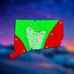
The 4 Seasons Posted February 26, 2022 Author Share Posted February 26, 2022 Here is the totals map from CT for this storm. Thanks to everyone who sent me messages for the totals. Sometimes i can only use one if i have multiples for one town but i tried to fit them the best i could. The forecast did not go very well for most of the state that fell below the ranges. One good thing i can say is that there was a distinct south to north gradient which we had been highlighting and stating in multiple maps/text. We did end up being in the range for the northern 1/4 of CT. Thats about it that saved it from being an F. Wasn't a complete bust but certainly much lower than forecast. The sleet/freezing rain map we put out did pretty well though. For this one i made an ice accumulation map from the data i was able to gather from ASOS and a few other reports. Final Grade: D Snowfall Totals: Final Call: Freezing Rain Totals: Final Call Sleet/Freezing Rain: Town-by-town totals: 2 Link to comment Share on other sites More sharing options...
The 4 Seasons Posted February 26, 2022 Author Share Posted February 26, 2022 3 minutes ago, tavwtby said: is that 29.3 for my obs? it's a bit off what I have, not by much but perhaps I mistyped or missed a small event, my obs data has me at 28.5" on the season, including this past event... I haven't gotten on the snow obs thread yet to enter my obs, gotta get on that, hard to do from phone and usually when I'm in my office I primarily focus on work stuff yea thats you. When you send me a PM you said "24.5 pitful" after the last storm and you said you got 4.8 (4.75) from this one. So i just added them to get 29.3. If its 28.5 ill change it to that no problem Link to comment Share on other sites More sharing options...
tavwtby Posted February 26, 2022 Share Posted February 26, 2022 Just now, The 4 Seasons said: yea thats you. When you send me a PM you said "24.5 pitful" after the last storm and you said you got 4.8 (4.75) from this one. So i just added them to get 29.3. If its 28.5 ill change it to that no problem keep it for now let me look at my obs, and I'll get back to you, I mean it's not like we're talking about inches here, but maybe I mistyped one of my obs in the spreadsheet, I've got hand notes too to backup Link to comment Share on other sites More sharing options...
The 4 Seasons Posted February 26, 2022 Author Share Posted February 26, 2022 1 minute ago, tavwtby said: keep it for now let me look at my obs, and I'll get back to you, I mean it's not like we're talking about inches here, but maybe I mistyped one of my obs in the spreadsheet, I've got hand notes too to backup lol i already changed it, but lmk whatever you got. thanks for the obs. you're the only one i got in the NW hills. 1 Link to comment Share on other sites More sharing options...
tavwtby Posted February 26, 2022 Share Posted February 26, 2022 6 minutes ago, The 4 Seasons said: lol i already changed it, but lmk whatever you got. thanks for the obs. you're the only one i got in the NW hills. no prob, there's someone else on this forum from torrington, though I don't see post much, white( something), lawns maybe?? Link to comment Share on other sites More sharing options...
Spanks45 Posted February 26, 2022 Share Posted February 26, 2022 20 minutes ago, The 4 Seasons said: Here is the totals map from CT for this storm. Thanks to everyone who sent me messages for the totals. Sometimes i can only use one if i have multiples for one town but i tried to fit them the best i could. The forecast did not go very well for most of the state that fell below the ranges. One good thing i can say is that there was a distinct south to north gradient which we had been highlighting and stating in multiple maps/text. We did end up being in the range for the northern 1/4 of CT. Thats about it that saved it from being an F. Wasn't a complete bust but certainly much lower than forecast. The sleet/freezing rain map we put out did pretty well though. For this one i made an ice accumulation map from the data i was able to gather from ASOS and a few other reports. Final Grade: D Snowfall Totals: Final Call: Freezing Rain Totals: Final Call Sleet/Freezing Rain: Town-by-town totals: 2.8" of mostly sleet here, did not take a core, just melted down what fell in the stratus and it had a remarkable 1.05"....if only it was all snow....maybe next year 1 Link to comment Share on other sites More sharing options...
40/70 Benchmark Posted February 27, 2022 Share Posted February 27, 2022 Friday Winter Storm Verification Successful But Flawed Forecast Here is the forecast map issued on Thursday afternoon for the Final Call. Versus what actually transpired yesterday. The forecast was fairly accurate, however, the predicted ranges were slightly too heavy overall. Namely, there were no 12" amounts, as the coastal front that was expected to augment mid level lift over se NH remained off shore and down into the immediate Boston area. Thus this small 10-14" should have simply been included in general range, which would have been better served being 7-11", rather than the 8-12 range that was employed. Finally, the 6-10" zone should have been shifted a bit to the north, outside of CT and RI, as it was in the First Call issued last Sunday. Otherwise, the 1-3" and 3-6" utilized across these states were in fact appropriate. Final Grade: B- 2 Link to comment Share on other sites More sharing options...
40/70 Benchmark Posted February 27, 2022 Share Posted February 27, 2022 I expected highest totals in N CT & RI to be around 6", hence the southern portion of the 6-10" range, so that looks worse than it was. I think there were some 5.5" amounts, or thereabouts. Link to comment Share on other sites More sharing options...
Ginx snewx Posted February 27, 2022 Share Posted February 27, 2022 3 hours ago, The 4 Seasons said: Here's where we are at for the season. I checked the New England wx site and for the people that haven't updated yet i just added this storm to your towns total. Didn't see anything from @JC-CT We got quite a gradient across CT right now. Again, thank you for all the reports. JC MIA after the blizzard missed him. Check the dive bars in IJD for a guy mumbling in the corner, 10 fuking miles, 10 fuking miles Link to comment Share on other sites More sharing options...
Ginx snewx Posted February 27, 2022 Share Posted February 27, 2022 5 hours ago, dendrite said: I got adventurous and decided to shovel the whole driveway and run so it could melt down to the ground. After 6hrs I think I’m going to have a major sunburn on my face. I was down to a tshirt despite temps in the low 20s. That sun gets potent between the combo of direct radiation and reflected from the high albedo. Looks good when it’s done. And oh yeah, love the pics of your little ones in the snow. Gorgeous Link to comment Share on other sites More sharing options...
Ginx snewx Posted February 27, 2022 Share Posted February 27, 2022 5 minutes ago, 40/70 Benchmark said: I expected highest totals in N CT & RI to be around 6", hence the southern portion of the 6-10" range, so that looks worse than it was. I think there were some 5.5" amounts, or thereabouts. Nice job Ray 1 Link to comment Share on other sites More sharing options...
40/70 Benchmark Posted February 27, 2022 Share Posted February 27, 2022 18 minutes ago, Ginx snewx said: Nice job Ray First call from Sunday was actually better there Haha. Thanks, Steve. Link to comment Share on other sites More sharing options...
Hazey Posted February 27, 2022 Share Posted February 27, 2022 7.5” final here. In the ball park with most other obs. #NovaScotiaStrong Link to comment Share on other sites More sharing options...
JC-CT Posted March 3, 2022 Share Posted March 3, 2022 On 2/26/2022 at 4:42 PM, The 4 Seasons said: Here's where we are at for the season. I checked the New England wx site and for the people that haven't updated yet i just added this storm to your towns total. Didn't see anything from @JC-CT We got quite a gradient across CT right now. Again, thank you for all the reports. I had about 3, so same color Link to comment Share on other sites More sharing options...

Recommended Posts
Create an account or sign in to comment
You need to be a member in order to leave a comment
Create an account
Sign up for a new account in our community. It's easy!
Register a new accountSign in
Already have an account? Sign in here.
Sign In Now