DLMKA Posted October 11, 2021 Share Posted October 11, 2021 Much of west central IL has very poor coverage on Verizon network so if that's your data source be aware of slow or non-existent data coverage. Macomb to Quincy and quincy to Jacksonville and jacksonville to havana and havana to Macomb is almost complete dead zone. AT&T is better. US Cellular is best. If anyone is chasing and wants a co-pilot that knows most of west central IL fairly well I'm game. I live just west of Peoria. Link to comment Share on other sites More sharing options...
m22 Posted October 11, 2021 Share Posted October 11, 2021 Looks like KILX radar is down....again. Great timing. Link to comment Share on other sites More sharing options...
SchaumburgStormer Posted October 11, 2021 Share Posted October 11, 2021 14 minutes ago, m22 said: Looks like KILX radar is down....again. Great timing. I saw that the radar is operating normally, there is just some issue with getting the feed to the web. Link to comment Share on other sites More sharing options...
WeatherMonger Posted October 11, 2021 Share Posted October 11, 2021 5 minutes ago, SchaumburgStormer said: I saw that the radar is operating normally, there is just some issue with getting the feed to the web. Link to comment Share on other sites More sharing options...
CheeselandSkies Posted October 11, 2021 Share Posted October 11, 2021 System almost looks like a TC on satellite. Clearing is confined to a narrow corridor E-W, but storms should be moving almost due northward. Clearing starting to nose into areas near/east of Keokuk, IA. Edit: 15Z HRRR has the mother lode tracking through eastern Lee/western DeKalb Counties (IL) around 20Z. Confirms my hunch attm that Rochelle is as good a jumping off point as any. Link to comment Share on other sites More sharing options...
Malacka11 Posted October 11, 2021 Share Posted October 11, 2021 My plan is to head down to Peoria, and see what forms to meet me. Glad that the chase should take me back home naturally. Does this sound like a reasonable plan? Link to comment Share on other sites More sharing options...
WeatherMonger Posted October 11, 2021 Share Posted October 11, 2021 ILX radar is updating now. Link to comment Share on other sites More sharing options...
Chicago Storm Posted October 11, 2021 Share Posted October 11, 2021 I'm still pondering heading down to W IL...We'll see.Have ditched this idea.. Link to comment Share on other sites More sharing options...
Malacka11 Posted October 11, 2021 Share Posted October 11, 2021 2 minutes ago, Chicago Storm said: Have ditched this idea. . So not going at all, or staying closer nearby? Link to comment Share on other sites More sharing options...
Chicago Storm Posted October 11, 2021 Share Posted October 11, 2021 So not going at all, or staying closer nearby?Given how things have evolved over the past several hours, I don’t see it worth me going anymore.Will obviously continue to monitor things, especially more locally for later.. Link to comment Share on other sites More sharing options...
Indystorm Posted October 11, 2021 Share Posted October 11, 2021 First tor warning of today's episode. BULLETIN - EAS ACTIVATION REQUESTED TORNADO WARNING NATIONAL WEATHER SERVICE ST LOUIS MO 102 PM CDT MON OCT 11 2021 THE NATIONAL WEATHER SERVICE IN ST LOUIS HAS ISSUED A * TORNADO WARNING FOR... NORTHWESTERN BOND COUNTY IN SOUTH CENTRAL ILLINOIS... EASTERN MADISON COUNTY IN SOUTHWESTERN ILLINOIS... SOUTHEASTERN MACOUPIN COUNTY IN SOUTHWESTERN ILLINOIS... SOUTHWESTERN MONTGOMERY COUNTY IN SOUTH CENTRAL ILLINOIS... * UNTIL 145 PM CDT. * AT 102 PM CDT, A SEVERE THUNDERSTORM CAPABLE OF PRODUCING A TORNADO WAS LOCATED NEAR MARINE, MOVING NORTHEAST AT 45 MPH. HAZARD...TORNADO. SOURCE...RADAR INDICATED ROTATION. IMPACT...FLYING DEBRIS WILL BE DANGEROUS TO THOSE CAUGHT WITHOUT SHELTER. MOBILE HOMES WILL BE DAMAGED OR DESTROYED. DAMAGE TO ROOFS, WINDOWS, AND VEHICLES WILL OCCUR. TREE DAMAGE IS LIKELY. * THIS DANGEROUS STORM WILL BE NEAR... MARINE AROUND 105 PM CDT. WORDEN AND ALHAMBRA AROUND 115 PM CDT. LIVINGSTON AROUND 120 PM CDT. OTHER LOCATIONS IN THE PATH OF THIS TORNADIC THUNDERSTORM INCLUDE STAUNTON, MOUNT OLIVE, SORENTO, TAYLOR SPRINGS, LITCHFIELD, HILLSBORO AND SCHRAM CITY. Link to comment Share on other sites More sharing options...
vortex Posted October 11, 2021 Share Posted October 11, 2021 Looks like a Tornado Watch out til 9 for much better of N and C IL 1 Link to comment Share on other sites More sharing options...
StormfanaticInd Posted October 11, 2021 Author Share Posted October 11, 2021 Storms getting ready to enter western Indiana Link to comment Share on other sites More sharing options...
Malacka11 Posted October 11, 2021 Share Posted October 11, 2021 Really good clearing around streator Link to comment Share on other sites More sharing options...
Indystorm Posted October 11, 2021 Share Posted October 11, 2021 Those pockets of clearing behind this initial rain do concern me as it will ramp up instability. Confirmed tors sw and west of Springfield Illinois Link to comment Share on other sites More sharing options...
Indystorm Posted October 11, 2021 Share Posted October 11, 2021 E NATIONAL WEATHER SERVICE IN LINCOLN HAS ISSUED A * TORNADO WARNING FOR... SOUTHEASTERN FULTON COUNTY IN WEST CENTRAL ILLINOIS... WEST CENTRAL TAZEWELL COUNTY IN CENTRAL ILLINOIS... NORTH CENTRAL MASON COUNTY IN CENTRAL ILLINOIS... * UNTIL 415 PM CDT. * AT 350 PM CDT, A CONFIRMED TORNADO WAS LOCATED OVER HAVANA, MOVING NORTHEAST AT 25 MPH. HAZARD...DAMAGING TORNADO. SOURCE...WEATHER SPOTTERS CONFIRMED TORNADO. IMPACT...FLYING DEBRIS WILL BE DANGEROUS TO THOSE CAUGHT WITHOUT SHELTER. MOBILE HOMES WILL BE DAMAGED OR DESTROYED. DAMAGE TO ROOFS, WINDOWS, AND VEHICLES WILL OCCUR. TREE DAMAGE IS LIKELY. * THIS TORNADIC THUNDERSTORM WILL REMAIN OVER MAINLY RURAL AREAS OF SOUTHEASTERN FULTON, WEST CENTRAL TAZEWELL AND NORTH CENTRAL MASON COUNTIES, INCLUDING THE FOLLOWING LOCATIONS... LIVERPOOL, LITTLE AMERICA, GOOFY RIDGE AND CHATAUQUA PARK. Link to comment Share on other sites More sharing options...
Chinook Posted October 11, 2021 Share Posted October 11, 2021 location of two confirmed tornado warnings several minutes ago (3:53pm Central), also, prelim. tornado report near Jacksonville IL Link to comment Share on other sites More sharing options...
Malacka11 Posted October 11, 2021 Share Posted October 11, 2021 Confirming a fat funnel near benson Link to comment Share on other sites More sharing options...
Malacka11 Posted October 11, 2021 Share Posted October 11, 2021 On the ground, small debris cloud 3 Link to comment Share on other sites More sharing options...
kevlon62 Posted October 11, 2021 Share Posted October 11, 2021 On the ground, small debris cloudNice work.Sent from my SM-N960U using Tapatalk 1 Link to comment Share on other sites More sharing options...
A-L-E-K Posted October 11, 2021 Share Posted October 11, 2021 Was surprisingly high quality here Link to comment Share on other sites More sharing options...
Malacka11 Posted October 11, 2021 Share Posted October 11, 2021 Big shelf clouds abound now, not sure what my next move should be Link to comment Share on other sites More sharing options...
SchaumburgStormer Posted October 11, 2021 Share Posted October 11, 2021 6 minutes ago, Malacka11 said: Big shelf clouds abound now, not sure what my next move should be I’d shoot north up 39 to see if you can get on that cell near Peru. Storm speed may be challenging though Link to comment Share on other sites More sharing options...
Malacka11 Posted October 11, 2021 Share Posted October 11, 2021 I managed to make my way there by accident but the rain is a real mess so we'll see if anything comes of it Link to comment Share on other sites More sharing options...
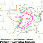
Chicago Storm Posted October 11, 2021 Share Posted October 11, 2021 Looks like a corridor of slight risk worthy activity will verify across C IL into E IN. Today performed about as good as it could given the situation.If there had been more clearing, which only would have been possible if that initial axis of rain/t’storms didn’t exist, it definitely would have been a more significant event.That SPC mega size 5% tor area from previous outlooks was still horrendous.. Link to comment Share on other sites More sharing options...
Chicago Storm Posted October 11, 2021 Share Posted October 11, 2021 Confirming a fat funnel near bensonNice bag.I ended up not going out in the end, which was a reasonable decision. The isolated mini supercells were too few in quantity in the end, and only two produced. The QLCS has actually been the bigger story surprisingly, with numerous MV’s embedded in the line. However, there has been an overall lack of reports of any mode of severe associated with it. 1 Link to comment Share on other sites More sharing options...
Tezeta Posted October 11, 2021 Share Posted October 11, 2021 4 minutes ago, Chicago Storm said: Nice bag. I ended up not going out in the end, which was a reasonable decision. The isolated mini supercells were too few in quantity in the end, and only two produced. The QLCS has actually been the bigger story surprisingly, with numerous MV’s embedded in the line. However, there have been an overall lack of reports of any mode of severe associated with it. . This sounds like spin IMO Link to comment Share on other sites More sharing options...
Chicago Storm Posted October 12, 2021 Share Posted October 12, 2021 1 hour ago, Tezeta said: This sounds like spin IMO naso much. Link to comment Share on other sites More sharing options...
vortex Posted October 12, 2021 Share Posted October 12, 2021 Couple of stills from the tornado warned cell near McNabb, Illinois this evening. Around 5:30-5:45 pm. Came close to producing but became wrapped in rain from my location so couldn’t see if it ever did. 5 Link to comment Share on other sites More sharing options...
Albino Squirrel Posted October 12, 2021 Share Posted October 12, 2021 We had a good deal of damage across Olney around 330 pm today. I had some minor damage at the house. One house had a tree go down through the middle and several other had damage. Link to comment Share on other sites More sharing options...

Recommended Posts
Create an account or sign in to comment
You need to be a member in order to leave a comment
Create an account
Sign up for a new account in our community. It's easy!
Register a new accountSign in
Already have an account? Sign in here.
Sign In Now