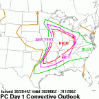
StormfanaticInd Posted October 10, 2021 Share Posted October 10, 2021 Day 2 Convective Outlook NWS Storm Prediction Center Norman OK 1258 AM CDT Sun Oct 10 2021 Valid 111200Z - 121200Z ...THERE IS A SLIGHT RISK OF SEVERE THUNDERSTORMS FROM THE MID MISSISSIPPI/LOWER OHIO VALLEYS NORTHWARD INTO THE UPPER GREAT LAKES... ...SUMMARY... Strong/isolated severe storms -- including potential for hail, locally damaging winds, and a couple of tornadoes -- are expected to spread from the Mid Mississippi Valley region early, north-northeastward into the Upper Great Lakes through the evening/overnight hours Monday and into early Tuesday. ...Synopsis... An upper trough digging south-southeastward across California and the Great Basin Monday will evolve into a closed low, which is expected deepen and turn eastward overnight reaching the southwestern Utah vicinity Tuesday morning. Ahead of this system, a negatively tilted short-wave trough will be shifting northeastward across the Lower Missouri and Mid Mississippi Valleys during the day, before crossing the Upper Great Lakes region overnight. Meanwhile, ridging will remain in place -- aligned roughly along the Appalachians. At the surface, a cold front associated with the western U.S. trough will sweep across the Great Basin and into the Four Corners states. Meanwhile, a cold front shifting eastward out of the southern Plains toward the Mississippi Valley will weaken with time, while an associated/weak frontal low advances northeastward from Missouri to Wisconsin/Upper Michigan through the period. ...Mid Mississippi Valley northward into the Upper Great Lakes... Showers and scattered thunderstorms will likely be ongoing at the start of the period from western Illinois/Missouri south-southwestward to southeastern Texas, ahead of an advancing cold front. A couple of stronger storms ongoing early could pose local risk for severe weather. After a few hours of local/limited risk, diurnal heating through late morning and into the afternoon will permit sufficient destabilization to allow gradual reintensification/redevelopment of storms, from Illinois to the Mississippi Delta region, then spreading northward and northeastward through the afternoon. Though flow aloft will remain largely south-southwesterly/unidirectional, sufficient speed shear combined with weak veering through the lowest 1 km or so suggests that locally severe/rotating storms will evolve, with threat for damaging wind gusts, along with some hail risk and potential for a couple of tornadoes across a relatively broad geographic region. A bit more uncertainty exists with northward extent, and into the evening hours, into the Great Lakes region. While ascent will spread across this region supporting a continuation of convection through the evening and into the overnight hours, less substantial instability -- diminishing further in tandem with diurnal cooling -- suggests that severe risk will wane gradually from late evening onward. 1 Link to comment Share on other sites More sharing options...
Chicago Storm Posted October 10, 2021 Share Posted October 10, 2021 Tomorrow will be highly dependent on debris from tonights activity that moves across the region tomorrow. It won’t take much clearing to make for a favorable environment ahead of the low/front in IL, so it’ll have to be watched. IL is really the main focus, as that huge slight risk from the SPC is way overdone.. 2 Link to comment Share on other sites More sharing options...
Malacka11 Posted October 10, 2021 Share Posted October 10, 2021 Not trying to be annoying, but when and where exactly should one be, hypothetically, to get the most out of this event? By coincidence, I have nothing to do after 1pm tomorrow Link to comment Share on other sites More sharing options...
Hoosier Posted October 10, 2021 Share Posted October 10, 2021 I suppose I'll take a middle ground between SPC and Chi Storm. I think the size of the risk area is overdone but I think the threat extends east of IL. Link to comment Share on other sites More sharing options...
CheeselandSkies Posted October 10, 2021 Share Posted October 10, 2021 Looking at the models yesterday, the instability/EHI values weren't too impressive anywhere except Michigan. Link to comment Share on other sites More sharing options...
Chicago Storm Posted October 10, 2021 Share Posted October 10, 2021 I suppose I'll take a middle ground between SPC and Chi Storm. I think the size of the risk area is overdone but I think the threat extends east of IL.I’m talking about the main threat, like 5% tor worthy threat (Not that it’s even worthy of that right now). That will be limited to IL.. Link to comment Share on other sites More sharing options...
StormfanaticInd Posted October 10, 2021 Author Share Posted October 10, 2021 Link to comment Share on other sites More sharing options...
StormfanaticInd Posted October 10, 2021 Author Share Posted October 10, 2021 Illinois does seem to be the prime spot for tomorrow Link to comment Share on other sites More sharing options...
Hoosier Posted October 10, 2021 Share Posted October 10, 2021 1 hour ago, Chicago Storm said: I’m talking about the main threat, like 5% tor worthy threat (Not that it’s even worthy of that right now). That will be limited to IL. . I gotcha Link to comment Share on other sites More sharing options...
hlcater Posted October 10, 2021 Share Posted October 10, 2021 Sit on the surface low tomorrow and profit off some high octane tornadic rain showers. 1 Link to comment Share on other sites More sharing options...
cyclone77 Posted October 10, 2021 Share Posted October 10, 2021 5 minutes ago, hlcater said: Sit on the surface low tomorrow and profit off some high octane tornadic rain showers. I plan on viewing one or two from my front porch. 1 Link to comment Share on other sites More sharing options...
CheeselandSkies Posted October 10, 2021 Share Posted October 10, 2021 May is overrated, Aug./Oct. are where it's at. 1 Link to comment Share on other sites More sharing options...
StormfanaticInd Posted October 10, 2021 Author Share Posted October 10, 2021 4 minutes ago, CheeselandSkies said: May is overrated, Aug./Oct. are where it's at. Facts Link to comment Share on other sites More sharing options...
CheeselandSkies Posted October 10, 2021 Share Posted October 10, 2021 Based on wind profiles in forecast soundings and associated CAM output, if chasing tomorrow be prepared for cells to be moving northward or perhaps even NNW. Not something one usually looks for unless a TC is involved. 1 Link to comment Share on other sites More sharing options...
Malacka11 Posted October 11, 2021 Share Posted October 11, 2021 How are things looking? Link to comment Share on other sites More sharing options...
Chicago Storm Posted October 11, 2021 Share Posted October 11, 2021 How are things looking?Pretty much the same as it has...The quality of threat will be dependent on how much clearing is seen through the day. Still looks like best risk is across IL (maybe into NE MO/SE IA and W IN as well).. 1 Link to comment Share on other sites More sharing options...
Malacka11 Posted October 11, 2021 Share Posted October 11, 2021 2 minutes ago, Chicago Storm said: Pretty much the same as it has... The quality of threat will be dependent on how much clearing is seen through the day. Still looks like best risk is across IL (maybe into NE MO/SE IA and W IN as well). . Fair, thank you Link to comment Share on other sites More sharing options...
WeatherMonger Posted October 11, 2021 Share Posted October 11, 2021 Mesoscale Discussion 1831 NWS Storm Prediction Center Norman OK 0906 AM CDT Mon Oct 11 2021 Areas affected...eastern MO...western and central IL Concerning...Severe potential...Watch possible Valid 111406Z - 111630Z Probability of Watch Issuance...60 percent SUMMARY...Trends will be monitored this morning for surface-based thunderstorm development. The initial area of concern will be over central MO and areas northeastward towards the MS River. A tornado watch will likely be needed by midday for portions of eastern MO into western IL. It is uncertain whether surface-based storms and a subsequent tornado risk will develop as far north as extreme eastern IA. DISCUSSION...Visible-satellite imagery shows a compact/intense mid-level shortwave trough over the lower MO Valley. Weak convection has been maintained this morning within the warm conveyer belt from southeast MO through the Saint Louis area and into western IL. A surface trough/windshift is analyzed this morning arcing from near the low through central and south-central MO. A small area of cloud breaks is noted in visible-satellite imagery over central MO where forcing is maximized and over the location of greatest concern this morning. Model forecast soundings show gradual destabilization this morning into the midday hours as temperatures slowly rise into the lower 70s with a moist boundary layer. Very strong low-level flow noted at the Saint Louis 88D VAD is resulting in a large low-level hodograph (400+ m2/s2 0-1 km SRH). Once sufficiently strong updrafts can develop/persist, a severe risk will likely ensue with an isolated risk for tornadoes and damaging winds being the primary concerns. ..Smith/Hart.. 10/11/2021 Link to comment Share on other sites More sharing options...
Malacka11 Posted October 11, 2021 Share Posted October 11, 2021 Worth chasing if you've literally got nothing better to do? Link to comment Share on other sites More sharing options...
purduewx80 Posted October 11, 2021 Share Posted October 11, 2021 2 minutes ago, Malacka11 said: Worth chasing if you've literally got nothing better to do? Storm motions will be on the order of 50-60MPH+. Link to comment Share on other sites More sharing options...
kevlon62 Posted October 11, 2021 Share Posted October 11, 2021 Why not. Get some fall colors.Sent from my SM-N960U using Tapatalk Link to comment Share on other sites More sharing options...
purduewx80 Posted October 11, 2021 Share Posted October 11, 2021 The referenced St. Louis VAD below. Link to comment Share on other sites More sharing options...
Chicago Storm Posted October 11, 2021 Share Posted October 11, 2021 10 minutes ago, Malacka11 said: Worth chasing if you've literally got nothing better to do? I'm still pondering heading down to W IL...We'll see. Link to comment Share on other sites More sharing options...
Malacka11 Posted October 11, 2021 Share Posted October 11, 2021 1 minute ago, Chicago Storm said: I'm still pondering heading down to W IL...We'll see. Let me know what you decide to do, I'm looking for any excuse to hit the road Link to comment Share on other sites More sharing options...
CheeselandSkies Posted October 11, 2021 Share Posted October 11, 2021 I'll be staying local, although latest HRRR is less than encouraging for S. WI. May head down to roughly I-88 corridor/Rochelle and hang out. Worked for me on 8/9, shoulda done it on 4/9/15. Link to comment Share on other sites More sharing options...
Scorpion Posted October 11, 2021 Share Posted October 11, 2021 What’s it looking like for SE WI? Thinking of heading up the Lapham Peak tower maybe I can get 65-70 kt winds again Link to comment Share on other sites More sharing options...
nwohweather Posted October 11, 2021 Share Posted October 11, 2021 1 hour ago, purduewx80 said: Storm motions will be on the order of 50-60MPH+. Maybe he meant storms chasing him Really though, in the Midwest that's okay from a chasing perspective. You've got tons of wide open field and flat land, easier to stay safe as long as you don't act like a lunatic and get right up in it Link to comment Share on other sites More sharing options...
Malacka11 Posted October 11, 2021 Share Posted October 11, 2021 Just now, nwohweather said: Maybe he meant storms chasing him Really though, in the Midwest that's okay from a chasing perspective. You've got tons of wide open field and flat land, easier to stay safe as long as you don't act like a lunatic and get right up in it Way I see it, if nothing else it'll be experience and practice for next time. To my knowledge, most of the terrain down there is great as long as you can stay away-ish from the Illinois River. Link to comment Share on other sites More sharing options...
nwohweather Posted October 11, 2021 Share Posted October 11, 2021 2 minutes ago, Malacka11 said: Way I see it, if nothing else it'll be experience and practice for next time. To my knowledge, most of the terrain down there is great as long as you can stay away-ish from the Illinois River. For sure I would. As long as you have a good radar app, stick to open space, and keep a safe distance you're good to go. Heck I remember when I was younger living in Ohio before the 4G cell days, I'd call a buddy with GRLevel and they'd give me a radar play by play while I chased. Then just let your eyes guide you and watch where the lowering/rotation is and stay out of hail 1 Link to comment Share on other sites More sharing options...
Malacka11 Posted October 11, 2021 Share Posted October 11, 2021 Just one issue... I have no idea where I should actually drive to. Link to comment Share on other sites More sharing options...

Recommended Posts
Create an account or sign in to comment
You need to be a member in order to leave a comment
Create an account
Sign up for a new account in our community. It's easy!
Register a new accountSign in
Already have an account? Sign in here.
Sign In Now