CT Rain Posted February 8, 2021 Share Posted February 8, 2021 17 minutes ago, ORH_wxman said: Yes, how tilted a system is matters, but also how far northwest into that tilt does the big lift penetrate. Those aren't always the easiest to diagnose. The models could be a little off on both aspects and you miss by 25 miles on a big band. The funny thing was is that the QPF forecasts weren't that bad - and the hires models way too high. I had 0.36" liquid here (5.2" of snow) which was pretty close to the mean on the GEFS/EPS/Euro/GFS and about 50% of the NAM. I wonder if that fronto band really went to town so far to the NW because it really maximized the snow growth zone and you had really efficient dendrite production. It's not like the band put down a ton of liquid - but it managed 15 or 20:1 ratios with efficient flake production. 1 Link to comment Share on other sites More sharing options...
CoastalWx Posted February 8, 2021 Share Posted February 8, 2021 5 minutes ago, CT Rain said: The funny thing was is that the QPF forecasts weren't that bad - and the hires models way too high. I had 0.36" liquid here (5.2" of snow) which was pretty close to the mean on the GEFS/EPS/Euro/GFS and about 50% of the NAM. I wonder if that fronto band really went to town so far to the NW because it really maximized the snow growth zone and you had really efficient dendrite production. It's not like the band put down a ton of liquid - but it managed 15 or 20:1 ratios with efficient flake production. The cross sections weren't all that helpful either. Lots of lift centered too far south and below the DGZ, but good fronto into and above the DGZ. I wonder if lapse rates helped in those areas that received good banding and induced more VVs through the DGZ compared to what guidance showed. Link to comment Share on other sites More sharing options...
CoastalWx Posted February 8, 2021 Share Posted February 8, 2021 Blue Hills 0.71" and 11.6" snow. Hingham, 6" and 0.61" liquid. Obviously near the water it was more 10:1. 2 Link to comment Share on other sites More sharing options...
78Blizzard Posted February 8, 2021 Share Posted February 8, 2021 1 hour ago, 40/70 Benchmark said: Wanted to share this great learning opportunity because it ruined what would have otherwise been an exemplary forecast. Its easy to forget that H7 fronto is simply a snapshot within the atmosphere, and that the coveted cross hair sig usually aligns with the SGZ region to the NW of max H7 fronto, since it slants NW to SE throughout the column with heights....as does low pressure (unless it is stacked). Super Bowl Sunday Snowfall Verification A Case of Misdiagnosed Frontogenesis The forecast was generally accurate, however, there was one glaring oversight that detracts a great deal from the overall forecast because involves the very heaviest band. The heaviest band of 8-12" extending from southwest of Boston down through northwest RI and NE CT was the result of an intense area of frontogensis that was misdiagnosed. Although the forecast did incorporate this: The fact that this band extended further to the northwest than forecast entailed that these very heavy snows also fell into slightly colder air, which resulted in a narrow band of 8-12", whereas the forecast 4-8" fell further to the south. This was a very large mistake that resulted in 3-6" being forecasted for that swath of real estate that was most heavily impacted with 8-12" in a very short amount of time. Thus the overall grade still suffers, despite an otherwise nearly flawless forecast. Final Grade: C That NWS map doesn't tell the whole story. It is only what fell between 3pm and 9pm. The areas in that band had several inches by 3pm. If we had a storm total of 13", then a place like Sharon or Millis probably had several inches more than that. Link to comment Share on other sites More sharing options...
powderfreak Posted February 8, 2021 Share Posted February 8, 2021 8 minutes ago, CT Rain said: The funny thing was is that the QPF forecasts weren't that bad - and the hires models way too high. I had 0.36" liquid here (5.2" of snow) which was pretty close to the mean on the GEFS/EPS/Euro/GFS and about 50% of the NAM. I wonder if that fronto band really went to town so far to the NW because it really maximized the snow growth zone and you had really efficient dendrite production. It's not like the band put down a ton of liquid - but it managed 15 or 20:1 ratios with efficient flake production. We were talking about that yesterday with some folks. The NAM and hires models were pretty bad but the 10:1 snow maps tricked some into thinking they were right. Link to comment Share on other sites More sharing options...
Baroclinic Zone Posted February 8, 2021 Share Posted February 8, 2021 Just now, CoastalWx said: Blue Hills 0.71" and 11.6" snow. Hingham, 6" and 0.61" liquid. Obviously near the water it was more 10:1. Yeah, we ended up pretty damn close to 10:1 here. Spot on to the 1/2" QPF Euro number we were seeing. Link to comment Share on other sites More sharing options...
CT Rain Posted February 8, 2021 Share Posted February 8, 2021 Just now, powderfreak said: We were talking about that yesterday with some folks. The NAM and hires models were pretty bad but the 10:1 snow maps tricked some into thinking they were right. Right for the wrong reason lol Link to comment Share on other sites More sharing options...
ORH_wxman Posted February 8, 2021 Share Posted February 8, 2021 ORH had 0.47" of QPF which was about double of the 00z Euro run the night before. 12z Euro run was slightly better but still off as it only had 0.30" of QPF. OTOH, the NAM had like 0.7" so it didn't fair any better. I agree with Ryan that the snow growth made the high QPF models look more correct than they were. They were way too juicy in most areas. 2 Link to comment Share on other sites More sharing options...
Ginx snewx Posted February 8, 2021 Share Posted February 8, 2021 6 minutes ago, ORH_wxman said: ORH had 0.47" of QPF which was about double of the 00z Euro run the night before. 12z Euro run was slightly better but still off as it only had 0.30" of QPF. OTOH, the NAM had like 0.7" so it didn't fair any better. I agree with Ryan that the snow growth made the high QPF models look more correct than they were. They were way too juicy in most areas. 8.5 with .58 water here. Last Euro was close 1 Link to comment Share on other sites More sharing options...
Lava Rock Posted February 8, 2021 Share Posted February 8, 2021 1 hour ago, BrianW said: Congrats Bridgeport. Yesterdays snow bumped them to 7th most above normal. only a few inches less than up here. Link to comment Share on other sites More sharing options...
powderfreak Posted February 8, 2021 Share Posted February 8, 2021 2 hours ago, CoastalWx said: It almost would have helped to have a product with 600mb plots. I bet that was near where the band set up. Maybe 650mb. That's what always gets me. That 600mb fronto after looking at 700mb snapshots. 1 Link to comment Share on other sites More sharing options...
CoastalWx Posted February 8, 2021 Share Posted February 8, 2021 10 minutes ago, powderfreak said: That's what always gets me. That 600mb fronto after looking at 700mb snapshots. I like to look at 700 and 500 and go from there. But, that is only as good as the model placement. If those features are off, banding will be off. Link to comment Share on other sites More sharing options...
dendrite Posted February 8, 2021 Share Posted February 8, 2021 1.7”/0.18” here. Poor growth. Link to comment Share on other sites More sharing options...
ORH_wxman Posted February 8, 2021 Share Posted February 8, 2021 Pack becoming pretty impressive. 4 Link to comment Share on other sites More sharing options...
mahk_webstah Posted February 8, 2021 Share Posted February 8, 2021 4 minutes ago, dendrite said: 1.7”/0.18” here. Poor growth. got a bit more here. Had one inch in one hour right around 1pm in a period of decent flakeage. 2.5 Link to comment Share on other sites More sharing options...
CoastalWx Posted February 8, 2021 Share Posted February 8, 2021 7 minutes ago, ORH_wxman said: Pack becoming pretty impressive. Yeah that's a pack. Link to comment Share on other sites More sharing options...
40/70 Benchmark Posted February 8, 2021 Share Posted February 8, 2021 11 minutes ago, CoastalWx said: Yeah that's a pack. That's about what I have. 2 1 Link to comment Share on other sites More sharing options...
OceanStWx Posted February 8, 2021 Share Posted February 8, 2021 4 hours ago, 40/70 Benchmark said: Wanted to share this great learning opportunity because it ruined what would have otherwise been an exemplary forecast. Final Grade: C Kudos on being honest with yourself. I wish we did less back patting after good events and more introspection after “bad” events locally. But we don’t want to offend anyone. Related to Scooter’s comment below, that’s why the big mesoscale snow band type paper uses layer averaged 700-500 mb f-gen. That will account for the slant of the system into the cold air. This band was right in the middle of that layer max on 12z guidance. Bad news is that layer is not often available on free websites, or even many paid sites. 3 hours ago, CoastalWx said: It almost would have helped to have a product with 600mb plots. I bet that was near where the band set up. Maybe 650mb. Link to comment Share on other sites More sharing options...
tamarack Posted February 8, 2021 Share Posted February 8, 2021 2 hours ago, dendrite said: 1.7”/0.18” here. Poor growth. Likewise. All small flakes and took 9 hours to make 2.3" on 0.20" LE. Still, it was the only 2"+ event here to top 10:1. Others have ranged from 4.5 to 9.7, with only a small amount of IP (in one event) and no ZR included. Makes for a solid pack, however, though 12/25 would've killed almost any pack. Link to comment Share on other sites More sharing options...
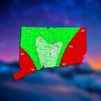
The 4 Seasons Posted February 8, 2021 Author Share Posted February 8, 2021 Here's the verification map and town by town totals map for the Feb 7th 2021 snowstorm in CT. I was always bullish on this one with a wide area of 4-8" being likely (minus NW CT) for a good chunk of SNE. We made the mistake of cutting back a bit right before the event started and i have to be honest and use that final call for the grade. The first call would likely be in the "B" range. Positives NW CT verified in the 2-4" range for most of litchfield and the northern part of Hartford counties. High totals in eastern CT verified, as noted with up to 8", even though they recieved more than that Many towns around i-84 verified in the 4-6" range as well as SE CT Negatives Far SE CT did not have the highest totals it was in that band from NE CT down to south central CT Large area of 6+ fell outside the range and several towns with 8+ Grade: C First call map: Northeast overview: Town-by-town snowfall totals...Thank you for all the reports! Dont forget to update your seasonal snowfall totals and ill update the CT STD map! 2 Link to comment Share on other sites More sharing options...
The 4 Seasons Posted February 9, 2021 Author Share Posted February 9, 2021 Drove around town today and took some photos. It's beautiful out there. 2 Link to comment Share on other sites More sharing options...

Recommended Posts
Create an account or sign in to comment
You need to be a member in order to leave a comment
Create an account
Sign up for a new account in our community. It's easy!
Register a new accountSign in
Already have an account? Sign in here.
Sign In Now