40/70 Benchmark Posted December 12, 2019 Share Posted December 12, 2019 7 hours ago, weatherwiz said: I'll chime in as well. Do you have bufkit, Ray? If not coolwx.com has great tools to see what you could with bufkit. coolwx.com > Hourly forecast models > then you can choose plot, station, and model on the left hand side. Here is the 0z 3K NAM for BDL: 1. the -12C to -18C range is illustrated...this is where snow growth is most optimized 2. I highlighted by the purple box where the negative values of omega area (negative values of omega indicate rising motion). Notice how you have very negative values of omega right inside the snowgrowth zone...this is referred to as a "cross hair signature". When this occurs and you have sufficient ice and RH in this layer (what's great about bufkit is you can overly RH with this...I'll post an example) you're not only going to maximize snow growth...but you're going to get very intense precip rates 3. I circled area of dry air in the low-levels around 6z or so...that was my flag for all this Now let's look at the RH profile. The time of snow was prior to 12z...well the heaviest anyways. Notice something...very moist...the dry air in the lower levels doesn't take over until around 12z...AFTER the precip has fallen. My mistake here was harping that drier air would be in place earlier...but between 0z-12z...you have a very deep moist profile here (noted by the high RH values through the troposphere Thanks, a lot...I'm going to begin incorporating this into my Final Calls, once we are at a very close range. @dendrite thank you, as well. 1 Link to comment Share on other sites More sharing options...
dryslot Posted December 12, 2019 Share Posted December 12, 2019 1 hour ago, dendrite said: It always looks like more than 6” in the dark. 2 Link to comment Share on other sites More sharing options...
Ginx snewx Posted December 12, 2019 Share Posted December 12, 2019 On 12/9/2019 at 9:31 PM, weatherwiz said: I will say this...there is a better chance of a widespread 3-6'' than Cole getting 9 years/$300+ million Cmon Wizzy Let's fuking go Yanks 2 Link to comment Share on other sites More sharing options...
CoastalWx Posted December 12, 2019 Share Posted December 12, 2019 The moon lit snow landscape with Christmas lights. Hopefully we don’t have to wait another 6 years again for that. Link to comment Share on other sites More sharing options...
HoarfrostHubb Posted December 12, 2019 Share Posted December 12, 2019 3 Link to comment Share on other sites More sharing options...
HoarfrostHubb Posted December 12, 2019 Share Posted December 12, 2019 Submitting photos has become a pain. 1 Link to comment Share on other sites More sharing options...
Ginx snewx Posted December 12, 2019 Share Posted December 12, 2019 10 minutes ago, HoarfrostHubb said: Submitting photos has become a pain. Screenshot um then crop and post Link to comment Share on other sites More sharing options...
HoarfrostHubb Posted December 12, 2019 Share Posted December 12, 2019 1 minute ago, Ginx snewx said: Screenshot um then crop and post Yeah. I did that. Took a few times to get it to orient the right way. Hope you are well Link to comment Share on other sites More sharing options...
40/70 Benchmark Posted December 12, 2019 Share Posted December 12, 2019 54 minutes ago, Ginx snewx said: Cmon Wizzy Let's fuking go Yanks I didn't get that comment....I knew he was going to NY for that money....no brainer. Maybe I should stick to baseball Link to comment Share on other sites More sharing options...
40/70 Benchmark Posted December 12, 2019 Share Posted December 12, 2019 Here my forecast obituary. https://easternmassweather.blogspot.com/2019/12/1211-verification-lifting-quality-of.html 1 Link to comment Share on other sites More sharing options...
dendrite Posted December 12, 2019 Share Posted December 12, 2019 58 minutes ago, 40/70 Benchmark said: Thanks, a lot...I'm going to begin incorporating this into my Final Calls, once we are at a very close range. @dendrite thank you, as well. I had a longer reply to you at work that I never sent...oops. Paul covered the basics well. Anyway, COMET offers some good tutorials. Are you registered there? https://www.meted.ucar.edu/training_course.php?id=6 Link to comment Share on other sites More sharing options...
40/70 Benchmark Posted December 12, 2019 Share Posted December 12, 2019 2 minutes ago, dendrite said: I had a longer reply to you at work that I never sent...oops. Paul covered the basics well. Anyway, COMET offers some good tutorials. Are you registered there? https://www.meted.ucar.edu/training_course.php?id=6 No. May be worth a look....soundings have always been an egregious hole on my knowledge base and I have never rectified that. Link to comment Share on other sites More sharing options...
dendrite Posted December 12, 2019 Share Posted December 12, 2019 4 minutes ago, 40/70 Benchmark said: No. May be worth a look....soundings have always been an egregious hole on my knowledge base and I have never rectified that. This is a good quick winter tutorial too. https://www.weather.gov/media/zhu/ZHU_Training_Page/winter_stuff/Winter_Stuff/Forecasting_P_Type.pdf 1 Link to comment Share on other sites More sharing options...
Damage In Tolland Posted December 12, 2019 Share Posted December 12, 2019 26 minutes ago, 40/70 Benchmark said: Here my forecast obituary. https://easternmassweather.blogspot.com/2019/12/1211-verification-lifting-quality-of.html You don’t have the NE CT hills circled . You have far NE Windham Cty. The NE CT hills are primarily in Tolland County over to Union in extreme NW Windham County .. all out of the circled area . I’ve seen many mets and others make this error over the years 1 Link to comment Share on other sites More sharing options...
40/70 Benchmark Posted December 12, 2019 Share Posted December 12, 2019 24 minutes ago, Damage In Tolland said: You don’t have the NE CT hills circled . You have far NE Windham Cty. The NE CT hills are primarily in Tolland County over to Union in extreme NW Windham County .. all out of the circled area . I’ve seen many mets and others make this error over the years It includes Union, which is in the hills. I know where Tolland is on the map.. Link to comment Share on other sites More sharing options...
raindancewx Posted December 12, 2019 Share Posted December 12, 2019 6 hours ago, 40/70 Benchmark said: Event next week could finish raindance....KO for KU.... My stuff works better seasonally then for months for snow. Look at Boston last year: Actual Analog Blend (1953-54, 1976-77, 1986-87, 1994-95 x2, 2006-07) Nov 0.1" (0.0+1.0+3.5+0.1+0.1+0.0)/6 = 0.8" Dec 0.1" (0.0+17.2+3.4+1.5+1.5+0.8)/6 = 4.1" Jan 2.1" (19.2+23.2+24.3+4.4+4.4+1.0)/6 = 12.8" Feb 11.6" (1.9+5.9+3.7+8.5+8.5+4.6)/6 = 5.5" Mar 13.5" (0.4+10.7+3.5+0.4+0.4+10.2)/6 = 4.3" Apr 0.0" (2.1+0.0+4.1+0.0+0.0+0.5) / 6 = 1.2" N-A 27.4" (0.8+4.1+12.8+5.5+4.3+1.2) = 28.7" At any given moment before the final total, it was out by 10" or so at some points. The math will snap toward the analog blend if the blend is right idea. This is what I had for Boston, in the raw blend - for 2019-20. Idea in the analogs was a lot of NE cities start strong then fade a lot late. Year Oct Nov Dec Jan Feb Mar Apr May Season 1953-1954 0 0 0 19.2 1.9 0.4 2.1 0 23.6 1953-1954 0 0 0 19.2 1.9 0.4 2.1 0 23.6 1983-1984 0 0 2.6 21.1 0.3 19 0 0 43 1983-1984 0 0 2.6 21.1 0.3 19 0 0 43 1992-1993 0 0.6 9.7 12.9 19.6 38.9 2.2 0 83.9 1995-1996 0 4.1 24.1 39.8 15.5 16.8 7.3 0 107.6 2009-2010 0.1 0 15.2 13.2 7 0.2 0 0 35.7 2009-2010 0.1 0 15.2 13.2 7 0.2 0 0 35.7 2009-2010 0.1 0 15.2 13.2 7 0.2 0 0 35.7 2018-2019 0 0.1 0.1 2.1 11.6 13.5 T 0 27.4 Blend 0.0 0.5 8.5 17.5 7.2 10.9 1.5 0.0 45.9 Link to comment Share on other sites More sharing options...
40/70 Benchmark Posted December 12, 2019 Share Posted December 12, 2019 1 hour ago, raindancewx said: My stuff works better seasonally then for months for snow. Look at Boston last year: Actual Analog Blend (1953-54, 1976-77, 1986-87, 1994-95 x2, 2006-07) Nov 0.1" (0.0+1.0+3.5+0.1+0.1+0.0)/6 = 0.8" Dec 0.1" (0.0+17.2+3.4+1.5+1.5+0.8)/6 = 4.1" Jan 2.1" (19.2+23.2+24.3+4.4+4.4+1.0)/6 = 12.8" Feb 11.6" (1.9+5.9+3.7+8.5+8.5+4.6)/6 = 5.5" Mar 13.5" (0.4+10.7+3.5+0.4+0.4+10.2)/6 = 4.3" Apr 0.0" (2.1+0.0+4.1+0.0+0.0+0.5) / 6 = 1.2" N-A 27.4" (0.8+4.1+12.8+5.5+4.3+1.2) = 28.7" At any given moment before the final total, it was out by 10" or so at some points. The math will snap toward the analog blend if the blend is right idea. This is what I had for Boston, in the raw blend - for 2019-20. Idea in the analogs was a lot of NE cities start strong then fade a lot late. Year Oct Nov Dec Jan Feb Mar Apr May Season 1953-1954 0 0 0 19.2 1.9 0.4 2.1 0 23.6 1953-1954 0 0 0 19.2 1.9 0.4 2.1 0 23.6 1983-1984 0 0 2.6 21.1 0.3 19 0 0 43 1983-1984 0 0 2.6 21.1 0.3 19 0 0 43 1992-1993 0 0.6 9.7 12.9 19.6 38.9 2.2 0 83.9 1995-1996 0 4.1 24.1 39.8 15.5 16.8 7.3 0 107.6 2009-2010 0.1 0 15.2 13.2 7 0.2 0 0 35.7 2009-2010 0.1 0 15.2 13.2 7 0.2 0 0 35.7 2009-2010 0.1 0 15.2 13.2 7 0.2 0 0 35.7 2018-2019 0 0.1 0.1 2.1 11.6 13.5 T 0 27.4 Blend 0.0 0.5 8.5 17.5 7.2 10.9 1.5 0.0 45.9 I was breaking balls for the most part. I agree its going to quiet down in January, but the key wwillbe whether or not second half blocking developes. I think that it will, but if not, it may be a short winter. Link to comment Share on other sites More sharing options...
SJonesWX Posted December 12, 2019 Share Posted December 12, 2019 12 hours ago, Ginx snewx said: South side hills here melted pretty good. Was pretty cool driving on southbound 395 with caked trees and woods with the northbound side pretty void of cake. i noticed the same thing yesterday on a north-south highway. trees on the west side of the highway were caked, trees on the east side, and the ground beneath them, was all bare. sun doing some work, even with the Dec sun angle. Link to comment Share on other sites More sharing options...
The 4 Seasons Posted December 12, 2019 Author Share Posted December 12, 2019 12 hours ago, Damage In Tolland said: Here is why Dec snow crushes Morch snow. It’s festive, it doesn’t melt in the sun and it gives a special feeling. You don’t worry about losing it until the next rainer whereas Morch it’s already gone 1000% agree. Everyone who loves snow loves Dec snow. I know some people, who actually hate snow, but love it anytime before Dec 25. Is there anyone who is actually prefers March snow over December? I mean ill take snow anytime i can get it but Id much rather have 30" in December than March, hell id rather have 20" in Dec than 30" in Mar. 1 Link to comment Share on other sites More sharing options...
dendrite Posted December 12, 2019 Share Posted December 12, 2019 I'd rather have 0" in March. Link to comment Share on other sites More sharing options...
Torch Tiger Posted December 12, 2019 Share Posted December 12, 2019 Longer days soon this month.. awesome 1 Link to comment Share on other sites More sharing options...
The 4 Seasons Posted December 12, 2019 Author Share Posted December 12, 2019 Shortest day of the year this month coming soon... Link to comment Share on other sites More sharing options...
dendrite Posted December 12, 2019 Share Posted December 12, 2019 Sunsets already getting later. Link to comment Share on other sites More sharing options...
The 4 Seasons Posted December 12, 2019 Author Share Posted December 12, 2019 2 minutes ago, dendrite said: Sunsets already getting later. That's interesting, so sunrises are getting earlier. According to google Sunset here is 4:22 for today, 13, 14 4:23 for 15,16,17 and 4:24 for 18,19,20. So it's increasing at about 20 seconds per day or 1/3min per day. According to Google our earliest sunset at this lat/long is 4:22PM Do you know why that is exactly? (Why sunsets are later but the days are still getting shorter?) Link to comment Share on other sites More sharing options...
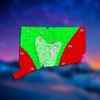
The 4 Seasons Posted December 12, 2019 Author Share Posted December 12, 2019 Wow, looks like there is way more snowfall totals on the PNS statements, ill have to update the map. Link to comment Share on other sites More sharing options...
weatherwiz Posted December 12, 2019 Share Posted December 12, 2019 12 hours ago, Ginx snewx said: Cmon Wizzy Let's fuking go Yanks I forgot about that post LOL. What an absurd contract. I should have known better than to bet against Cashman's trigger finger. Link to comment Share on other sites More sharing options...
The 4 Seasons Posted December 12, 2019 Author Share Posted December 12, 2019 Snowfall totals for major locations: GYX: T NYC: 0.2 PWM: 0.4 MHT: 0.5 PVD: 1.8 BDR: 2.4 RECORD BOS: 2.8 RECORD BDL: 3.0 ORH: 5.1 It's amazing how many all time records BDR is setting for such little snow, i think thats 3 so far for the month, ~70+ years of records. Link to comment Share on other sites More sharing options...
tamarack Posted December 12, 2019 Share Posted December 12, 2019 3 hours ago, The 4 Seasons said: 1000% agree. Everyone who loves snow loves Dec snow. I know some people, who actually hate snow, but love it anytime before Dec 25. Is there anyone who is actually prefers March snow over December? I mean ill take snow anytime i can get it but Id much rather have 30" in December than March, hell id rather have 20" in Dec than 30" in Mar. Since I like snow in any part of snow season, I'd take the 30" March. Another reason is that, even though December averages 12% more snow than March (19.6" to 17.6"), March has recorded 9 storms of a foot or more compared to 4 such events in December. A third is average snow depth. Over 21 winters Dec. 1 has averaged 1" (only 5 had 1"+) and increases to 9" by the 31st. March begins with 21" on average and still has 13" on 3/31. To each their own. Do you know why that is exactly? (Why sunsets are later but the days are still getting shorter?) Years ago I read a fairly detailed reason for this, and came away confused. Not sure whether that was due to a poor explanation or my lousy comprehension. 1 Link to comment Share on other sites More sharing options...
weatherwiz Posted December 12, 2019 Share Posted December 12, 2019 18 minutes ago, tamarack said: Since I like snow in any part of snow season, I'd take the 30" March. Another reason is that, even though December averages 12% more snow than March (19.6" to 17.6"), March has recorded 9 storms of a foot or more compared to 4 such events in December. A third is average snow depth. Over 21 winters Dec. 1 has averaged 1" (only 5 had 1"+) and increases to 9" by the 31st. March begins with 21" on average and still has 13" on 3/31. To each their own. Do you know why that is exactly? (Why sunsets are later but the days are still getting shorter?) Years ago I read a fairly detailed reason for this, and came away confused. Not sure whether that was due to a poor explanation or my lousy comprehension. sunrises are still happening later..and a longer day-to-day rate than what we're increasing sunsets with daily. (hope that made sense) Link to comment Share on other sites More sharing options...
weatherwiz Posted December 12, 2019 Share Posted December 12, 2019 the latest sunrise happens until about the second week of January...then sunset starts to happen earlier. Looks like we increase sunset on the magnitude of at least a minute right around Christmas or so. Link to comment Share on other sites More sharing options...

Recommended Posts
Create an account or sign in to comment
You need to be a member in order to leave a comment
Create an account
Sign up for a new account in our community. It's easy!
Register a new accountSign in
Already have an account? Sign in here.
Sign In Now