giventofly Posted December 11, 2019 Share Posted December 11, 2019 Snow just stopped and sun out in Middletown, RI. 4" Link to comment Share on other sites More sharing options...
TauntonBlizzard2013 Posted December 11, 2019 Share Posted December 11, 2019 Just like that, suns out. 6” final. Nice event Link to comment Share on other sites More sharing options...
SJonesWX Posted December 11, 2019 Share Posted December 11, 2019 1 hour ago, weatherwiz said: It was fun though walking outside this morning and seeing a wet paste of snow on everything. Nothing more beautiful than that. more beautiful than or even ? Link to comment Share on other sites More sharing options...
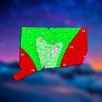
The 4 Seasons Posted December 11, 2019 Author Share Posted December 11, 2019 Final totals across the state vs. final call forecast. If there are any new or updated reports ill add them or if anyone has anything they want to add. I'm using my final call as always for verification, if i didn't chop the range down from 2-5 it would have been perfect. Grade: A 2 Link to comment Share on other sites More sharing options...
weatherwiz Posted December 11, 2019 Share Posted December 11, 2019 1 minute ago, SJonesWX said: more beautiful than or even ? yes...those are beautiful in a different way Link to comment Share on other sites More sharing options...
rnaude241 Posted December 11, 2019 Share Posted December 11, 2019 9 minutes ago, SouthCoastMA said: Heavy snow. Measuring in a bit Heavy snow here as well. Over-performed my expectations down here. 1 Link to comment Share on other sites More sharing options...
weatherwiz Posted December 11, 2019 Share Posted December 11, 2019 1 minute ago, The 4 Seasons said: Final totals across the state vs. final call forecast. If there are any new or updated reports ill add them or if anyone has anything they want to add. I'm using my final call as always for verification, if i didn't chop the range down from 2-5 it would have been perfect. Grade: A can't get better than that 1 Link to comment Share on other sites More sharing options...
SouthCoastMA Posted December 11, 2019 Share Posted December 11, 2019 1 minute ago, rnaude241 said: Heavy snow here as well. Over-performed my expectations down here. Sun just came out. Pretty cool Link to comment Share on other sites More sharing options...
Sugarloaf1989 Posted December 11, 2019 Share Posted December 11, 2019 4pm 12/10 and 12pm 12/11 2 Link to comment Share on other sites More sharing options...
Baroclinic Zone Posted December 11, 2019 Share Posted December 11, 2019 Final 5” Link to comment Share on other sites More sharing options...
The 4 Seasons Posted December 11, 2019 Author Share Posted December 11, 2019 5 minutes ago, weatherwiz said: can't get better than that except for my first call was 2-5 lol, thats why i gave it an A and not A+. But i did bump up numbers in the litchfield hills and glad i did. First Call, about 32 hours lead time Link to comment Share on other sites More sharing options...
The 4 Seasons Posted December 11, 2019 Author Share Posted December 11, 2019 Sun is out and literally everything melted on all paved surfaces. No shoveling, it's all gone. Grass blades showing through, i expect to be down to a trace by evening. Surprised schools were cancelled tbh. Link to comment Share on other sites More sharing options...
SouthCoastMA Posted December 11, 2019 Share Posted December 11, 2019 4.5" final here. Link to comment Share on other sites More sharing options...
weatherwiz Posted December 11, 2019 Share Posted December 11, 2019 4 minutes ago, The 4 Seasons said: except for my first call was 2-5 lol, thats why i gave it an A and not A+. But i did bump up numbers in the litchfield hills and glad i did. First Call, about 32 hours lead time hey you adjusted as necessary...nothing wrong with that. You saw the trends and acted...and rightfully so Link to comment Share on other sites More sharing options...
weathafella Posted December 11, 2019 Share Posted December 11, 2019 Really nice near south coast of MA! My final is 3.2. Link to comment Share on other sites More sharing options...
DomNH Posted December 11, 2019 Share Posted December 11, 2019 26 minutes ago, weatherwiz said: I'll chime in as well. Do you have bufkit, Ray? If not coolwx.com has great tools to see what you could with bufkit. coolwx.com > Hourly forecast models > then you can choose plot, station, and model on the left hand side. Here is the 0z 3K NAM for BDL: 1. the -12C to -18C range is illustrated...this is where snow growth is most optimized 2. I highlighted by the purple box where the negative values of omega area (negative values of omega indicate rising motion). Notice how you have very negative values of omega right inside the snowgrowth zone...this is referred to as a "cross hair signature". When this occurs and you have sufficient ice and RH in this layer (what's great about bufkit is you can overly RH with this...I'll post an example) you're not only going to maximize snow growth...but you're going to get very intense precip rates 3. I circled area of dry air in the low-levels around 6z or so...that was my flag for all this Now let's look at the RH profile. The time of snow was prior to 12z...well the heaviest anyways. Notice something...very moist...the dry air in the lower levels doesn't take over until around 12z...AFTER the precip has fallen. My mistake here was harping that drier air would be in place earlier...but between 0z-12z...you have a very deep moist profile here (noted by the high RH values through the troposphere Yep, BUFKIT is definitely your best friend when it comes to looking at the DGZ and trying to find funky dry layers. That BDL cross-section is an excellent signature for a short period of heavy high ratio snow. Of course BUFKIT and coolwx is limited to the American models. You can get some coarse SKEW-Ts for the globals but I don't know if there is anywhere to get cross-sections. Checking the cross-sections is good practice for any snow forecast. Sometimes you can find some flags. Link to comment Share on other sites More sharing options...
rnaude241 Posted December 11, 2019 Share Posted December 11, 2019 Suns out as the last flakes fall down. Beautiful little event. Link to comment Share on other sites More sharing options...
The 4 Seasons Posted December 11, 2019 Author Share Posted December 11, 2019 1 minute ago, DomNH said: Yep, BUFKIT is definitely your best friend when it comes to looking at the DGZ and trying to find funky dry layers. That BDL cross-section is an excellent signature for a short period of heavy high ratio snow. Of course BUFKIT and coolwx is limited to the American models. You can get some coarse SKEW-Ts for the globals but I don't know if there is anywhere to get cross-sections. Checking the cross-sections is good practice for any snow forecast. Sometimes you can find some flags. I'd kill to be able to get BUFKIT data for the EC/GEM/UKMET. Link to comment Share on other sites More sharing options...
Thunderblizzard Posted December 11, 2019 Share Posted December 11, 2019 2.9" final in Southington. 1 Link to comment Share on other sites More sharing options...
WinterWolf Posted December 11, 2019 Share Posted December 11, 2019 2 minutes ago, Thunderblizzard said: 2.9" final in Southington. Yup, I was gonna let him know, but you got us represented first, Nice. We add to the season total... Not too bad. Link to comment Share on other sites More sharing options...
40/70 Benchmark Posted December 11, 2019 Share Posted December 11, 2019 55 minutes ago, dendrite said: Yeah but that was 10:1 right? Maybe QPF overperformed a bit, but the banding looked pretty good so that's not too surprising. I didn't see coco obs, but I assume some of the bigger totals were pushing 15-20:1? That's right....I just missed the boat here... Link to comment Share on other sites More sharing options...
DavisStraight Posted December 11, 2019 Share Posted December 11, 2019 3 inch total here, sun out now going its work, at least the roads are wet. Link to comment Share on other sites More sharing options...
Ginx snewx Posted December 11, 2019 Share Posted December 11, 2019 1 hour ago, dendrite said: 00z 3km NAM from last night...cross sections through that banding. You can see the omega bullseye "crosshaired" through that max DGZ of -12C to -18C. That's pretty damn high up at 500mb, but if you look at the lower image the RH was high enough for deposition with respect to ice. Also, it was just moist enough in the low levels to prevent virga. This suggests a pretty sharp cutoff though with the sinking air just west of the banding and lower RH. Yes excellent representation Link to comment Share on other sites More sharing options...
40/70 Benchmark Posted December 11, 2019 Share Posted December 11, 2019 Looks like Everett, Malden, Melrose Wakefield, Saugus area had 3 to 3.5".. Link to comment Share on other sites More sharing options...
TauntonBlizzard2013 Posted December 11, 2019 Share Posted December 11, 2019 6” 16.70” season. Not bad for December 11th in SE Mass Link to comment Share on other sites More sharing options...
Ginx snewx Posted December 11, 2019 Share Posted December 11, 2019 13 minutes ago, TauntonBlizzard2013 said: 6” 16.70” season. Not bad for December 11th in SE Mass Meh lol Link to comment Share on other sites More sharing options...
Ginx snewx Posted December 11, 2019 Share Posted December 11, 2019 Sun spectacle Link to comment Share on other sites More sharing options...
CoastalWx Posted December 11, 2019 Share Posted December 11, 2019 Sounds like between 4-5 at home. We take. Link to comment Share on other sites More sharing options...
Damage In Tolland Posted December 11, 2019 Share Posted December 11, 2019 11 minutes ago, Ginx snewx said: Meh lol Don’t play his dumb game Link to comment Share on other sites More sharing options...
S&P Posted December 11, 2019 Share Posted December 11, 2019 4.5” final Portsmouth RI Link to comment Share on other sites More sharing options...

Recommended Posts
Create an account or sign in to comment
You need to be a member in order to leave a comment
Create an account
Sign up for a new account in our community. It's easy!
Register a new accountSign in
Already have an account? Sign in here.
Sign In Now