weatherwiz Posted December 10, 2019 Share Posted December 10, 2019 For Kevin... I will explain my step-by-step process with the forecast. I am not going to post any graphics b/c that will just eat up space. If I end up posing any it doesn't mean I am endorsing the model, just using it to illustrate what I'm saying. Mid/Upper Levels (700-250mb): Excellent jet dynamics with southern New England in a very favorable position with respect to jet streaks for upward vertical motion...and rather vigorous upward vertical motion which will be enhanced by positive vorticity advection and strong shortwave energy. Sufficient relative humidity and plenty of relative humidity with respect to ice (I'm not really sure how to explain that outside of how it's labeled on bufkit). Intense narrow zone of 700mb frontogenesis. Significance: All ingredients in place to generate clouds and the production of snow. Flag: Advection...where is the advection coming from? A WSW component to the streamlines (though some streamline convergence exists)...the key here is the component is more west than south. Why is this key? There is drier air to the west. This will ultimately advect in from the west (unless there was an off-setting force). Low-levels (925 to 700mb) Major red flags are in existence within the lowest 10,000 feet of the troposphere. These flags include a significant presence of dry air and subsidence. Significance: This is an extremely deep portion of the troposphere characterized drier air and subsidence. How is this going to influence things? IMO, we are not looking at very heft precipitation rates OUTSIDE OF WHERE THE FRONTO SETS UP...and I think this is east of CT (reasons for this are the intrusion of dry air and subsidence over our area...this is much less farther east which indicates where a boundary may be placed...boundary in this case the fronto). Whatever precipitation does fall has a tremendous way to travel before reaching the ground...having to fight both subsidence and dry air is not a good thing...especially if we can't even develop sufficient dendrites...which is a very real possibility here given the strongest lift is really not over us or in the SGZ. Wednesday morning, we'll see a radar which is very patchy and also misleading. Radar will suggest it's "snowing" somewhere but there will be a DBZ threshold needed for snow verification at the ground. Where the heavier echos are present is where you'll see snow...and a few things can happen from here... 1) Those localized areas are lucky and remain under those heavier echos or heavier echos develop over them or 2) These areas experience them but extremely brief This will be the difference between getting around a C to as much as 2-3''. But in terms of Wednesday morning radar coverage...this is exactly how I'm expecting it to look 1 1 Link to comment Share on other sites More sharing options...
40/70 Benchmark Posted December 10, 2019 Share Posted December 10, 2019 12z Euro 1 Link to comment Share on other sites More sharing options...
RUNNAWAYICEBERG Posted December 10, 2019 Share Posted December 10, 2019 Good stuff Wizzy. Very easy to follow, visually painted. 1 Link to comment Share on other sites More sharing options...
The 4 Seasons Posted December 10, 2019 Author Share Posted December 10, 2019 This is what makes forecasting fun. We are attempting to predict the future. If models were perfect, how boring would it be? Come Wednesday morning, some will have egg on their face and some won't. One thing i've learned over the years of met school and op forecasting is to not poke fun, laugh at or attack anyone who disagrees with me. It just hasn't happened yet. Over the years i've seen storms that have been forecasted to be 7-14" and end up with 0 and i've seen a chance flurries end up being 6-8". Link to comment Share on other sites More sharing options...
Ginx snewx Posted December 10, 2019 Share Posted December 10, 2019 Wiz that sounds like the GFS. Take a look at the Euro Link to comment Share on other sites More sharing options...
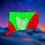
The 4 Seasons Posted December 10, 2019 Author Share Posted December 10, 2019 3 minutes ago, 40/70 Benchmark said: 12z Euro Interesting Pivotal weather clown map is higher with 2-3 for much of the state and a small area of 3-4 in interior E CT Link to comment Share on other sites More sharing options...
40/70 Benchmark Posted December 10, 2019 Share Posted December 10, 2019 Just now, The 4 Seasons said: Interesting Pivotal weather clown map is higher with 2-3 for much of the state and a small area of 3-4 in interior E CT It probably changes to snow too quickly....those clown maps blow. Link to comment Share on other sites More sharing options...
The 4 Seasons Posted December 10, 2019 Author Share Posted December 10, 2019 It's frustrating to take a deep dive at forecasting because BUFKIT and many sites with soundings only provide them for the GFS/NAM. Both of these models, imo, are inferior to the ECMWF. But the ECMWF i cant see soundings or use points on BUFKIT or even have an EC-MOS type data that i can get with the american models. Link to comment Share on other sites More sharing options...
40/70 Benchmark Posted December 10, 2019 Share Posted December 10, 2019 Just now, The 4 Seasons said: It's frustrating to take a deep dive at forecasting because BUFKIT and many sites with soundings only provide them for the GFS/NAM. Both of these models, imo, are inferior to the ECMWF. But the ECMWF i cant see soundings or use points on BUFKIT or even have an EC-MOS type data that i can get with the american models. Those F5 (Eurowx) clown maps are the only decent ones imo. Link to comment Share on other sites More sharing options...
Ginx snewx Posted December 10, 2019 Share Posted December 10, 2019 Just now, The 4 Seasons said: This is what makes forecasting fun. We are attempting to predict the future. If models were perfect, how boring would it be? Come Wednesday morning, some will have egg on their face and some won't. One thing i've learned over the years of met school and op forecasting is to not poke fun, laugh at or attack anyone who disagrees with me. It just hasn't happened yet. Over the years i've seen storms that have been forecasted to be 7-14" and end up with 0 and i've seen a chance flurries end up being 6-8". Yea some here are seemingly in a ego contest. The best fail with regularity. People waste learning opportunity cause they think they too good to cover an advisory level snow, its always good to better yourself. Increases the chances for better forecasts. 3 Link to comment Share on other sites More sharing options...
It's Always Sunny Posted December 10, 2019 Share Posted December 10, 2019 Just now, The 4 Seasons said: It's frustrating to take a deep dive at forecasting because BUFKIT and many sites with soundings only provide them for the GFS/NAM. Both of these models, imo, are inferior to the ECMWF. But the ECMWF i cant see soundings or use points on BUFKIT or even have an EC-MOS type data that i can get with the american models. I still have yet to find a website (including paid) that provides ECMWF soundings. If anyone knows of them please let me know. In the meantime I usually have to have 6 windows open with different variables displayed to paint a picture so to speak. Link to comment Share on other sites More sharing options...
40/70 Benchmark Posted December 10, 2019 Share Posted December 10, 2019 I think its also an issue of time allocation....I'm willing to bet that many hobbyists who gloss over light snow events do so because they aren't yet retired and have a family. 2 Link to comment Share on other sites More sharing options...
NorEastermass128 Posted December 10, 2019 Share Posted December 10, 2019 NAM gone zzz’s. Link to comment Share on other sites More sharing options...
weatherwiz Posted December 10, 2019 Share Posted December 10, 2019 7 minutes ago, Ginx snewx said: Wiz that sounds like the GFS. Take a look at the Euro I know the Euro does seem to increase QPF and total precip, however, I'm not totally sold on it. I think in these situations where we deal with a quick turnover, the QPF outputs become contaminated and end up being overdone. When I was looking at the Euro one thing I noticed regarding QPF was the majority of it seemed to fall prior and up to 12z Wednesday with not so much after that. One very difficult aspect here is the changeover probably starts occurring within the 6-hours between 6z and 12z...that's going to really throw a wrench in the QPF output. If certain things were different with this setup...I'd probably go somewhere along the lines of 6-12''+. Those mid/upper dynamics alone are about as impressive as you'll see...the lift in the mid/upper levels is going to be through the roof...but below that it's about as bad as you could want. IMO, it's that fronto zone which is going to deliver...and all indications are this will be extremely narrow...in fact, there may be even two focal areas of fronto...which would only further enhance subsidence/drying between them. Given how I think we have to rely on the fronto alone it's just for me to go on the higher side over a widespread area. Link to comment Share on other sites More sharing options...
FXWX Posted December 10, 2019 Share Posted December 10, 2019 2 minutes ago, It's Always Sunny said: I still have yet to find a website (including paid) that provides ECMWF soundings. If anyone knows of them please let me know. In the meantime I usually have to have 6 windows open with different variables displayed to paint a picture so to speak. AccuWx Pro 2 Link to comment Share on other sites More sharing options...
DomNH Posted December 10, 2019 Share Posted December 10, 2019 11 minutes ago, It's Always Sunny said: I still have yet to find a website (including paid) that provides ECMWF soundings. If anyone knows of them please let me know. In the meantime I usually have to have 6 windows open with different variables displayed to paint a picture so to speak. Accuweather Pro has coarse Euro soundings. 1 Link to comment Share on other sites More sharing options...
weatherwiz Posted December 10, 2019 Share Posted December 10, 2019 Just now, DomNH said: Accuweather Pro has coarse Euro soundings. That's sick!!! I'll have to start going there again. I used to like the page but since they did that face lift a few years ago I think it's been horrific...navigating between products and models and so forth...awful 1 Link to comment Share on other sites More sharing options...
Ginx snewx Posted December 10, 2019 Share Posted December 10, 2019 14 minutes ago, It's Always Sunny said: I still have yet to find a website (including paid) that provides ECMWF soundings. If anyone knows of them please let me know. In the meantime I usually have to have 6 windows open with different variables displayed to paint a picture so to speak. Best I can see but there are others 2 Link to comment Share on other sites More sharing options...
DomNH Posted December 10, 2019 Share Posted December 10, 2019 1 minute ago, weatherwiz said: That's sick!!! I'll have to start going there again. I used to like the page but since they did that face lift a few years ago I think it's been horrific...navigating between products and models and so forth...awful I agree that upgrade was a disaster but there’s an option to use the legacy model site which is what I do. Link to comment Share on other sites More sharing options...
weatherwiz Posted December 10, 2019 Share Posted December 10, 2019 3 minutes ago, Ginx snewx said: Best I can see but there are others where the heck do you go on the site to get those? Link to comment Share on other sites More sharing options...
WeatherX Posted December 10, 2019 Share Posted December 10, 2019 12 minutes ago, 40/70 Benchmark said: I think its also an issue of time allocation....I'm willing to bet that many hobbyists who gloss over light snow events do so because they aren't yet retired and have a family. You are readable when you are toned down, but mostly just COC assured at such a young age. You rub many the wrong way. Link to comment Share on other sites More sharing options...
weatherwiz Posted December 10, 2019 Share Posted December 10, 2019 2 minutes ago, DomNH said: I agree that upgrade was a disaster but there’s an option to use the legacy model site which is what I do. Really? I'll have to check it out. I loved the model animator before that upgrade...someone should be smacked for designing that Link to comment Share on other sites More sharing options...
weatherwiz Posted December 10, 2019 Share Posted December 10, 2019 Just now, WeatherX said: You are readable when you are toned down, but mostly just COC assured at such a young age. You rub many the wrong way. Kraft does not approve 4 Link to comment Share on other sites More sharing options...
78Blizzard Posted December 10, 2019 Share Posted December 10, 2019 49 minutes ago, Ginx snewx said: Nice wave on the front. Looks like a nice enhancement , semi baroclinic leaf. Temps drop pretty quickly. Wed morning commute in the heavily traveled 95 Northeast might have issues. Temps around these parts could be above freezing so most of what falls will not stick to the roads. Link to comment Share on other sites More sharing options...
WeatherX Posted December 10, 2019 Share Posted December 10, 2019 1 minute ago, weatherwiz said: Kraft does not approve You have stepped your game up Paul. I am a proud weenie 1 1 Link to comment Share on other sites More sharing options...
40/70 Benchmark Posted December 10, 2019 Share Posted December 10, 2019 5 minutes ago, WeatherX said: You are readable when you are toned down, but mostly just COC assured at such a young age. You rub many the wrong way. I couldn't care less. I'm not trying to forge a career, so I'm not mindful of mentally massaging prostates. Just an outlet for me. 2 Link to comment Share on other sites More sharing options...
weatherwiz Posted December 10, 2019 Share Posted December 10, 2019 Just now, WeatherX said: You have stepped your game up Paul. I am a proud weenie Link to comment Share on other sites More sharing options...
Ginx snewx Posted December 10, 2019 Share Posted December 10, 2019 5 minutes ago, weatherwiz said: where the heck do you go on the site to get those? https://lab.weathermodels.com/models/city/eps_charts.php Link to comment Share on other sites More sharing options...
weatherwiz Posted December 10, 2019 Share Posted December 10, 2019 1 minute ago, Ginx snewx said: https://lab.weathermodels.com/models/city/eps_charts.php Oh sweet thanks! I never went into that section of city charts...just did so via the drop down menu in the model animator Link to comment Share on other sites More sharing options...
moneypitmike Posted December 10, 2019 Share Posted December 10, 2019 given the dearth of NAM comments, it either sucks and/or others are getting it as slowly at Tidbits is posting it. Link to comment Share on other sites More sharing options...

Recommended Posts
Create an account or sign in to comment
You need to be a member in order to leave a comment
Create an account
Sign up for a new account in our community. It's easy!
Register a new accountSign in
Already have an account? Sign in here.
Sign In Now