The 4 Seasons Posted December 9, 2019 Author Share Posted December 9, 2019 18Z GFS actually ticked up a bit on the qpf side. Soundings still look fugly tho. Link to comment Share on other sites More sharing options...
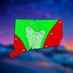
The 4 Seasons Posted December 9, 2019 Author Share Posted December 9, 2019 Clown map. I'll take my 6.0" of digital snow Link to comment Share on other sites More sharing options...
78Blizzard Posted December 9, 2019 Share Posted December 9, 2019 3 minutes ago, The 4 Seasons said: Clown map. I'll take my 6.0" of digital snow Me too. Link to comment Share on other sites More sharing options...
NorEastermass128 Posted December 9, 2019 Share Posted December 9, 2019 DC blockbuster down there. Link to comment Share on other sites More sharing options...
The 4 Seasons Posted December 9, 2019 Author Share Posted December 9, 2019 BOX cut totals a bit, now more realistic with widespread 3-4 rather than 4-6. ALY pretty much cancelled the storm, they really slashed totals less than 1/4 of what it was. Link to comment Share on other sites More sharing options...
Ginx snewx Posted December 9, 2019 Share Posted December 9, 2019 After the 18Z early runs are out no change in the 3 to 6 range. Will see what the Euro has. Still time to adjust. 1 Link to comment Share on other sites More sharing options...
Ginx snewx Posted December 9, 2019 Share Posted December 9, 2019 54 minutes ago, Damage In Tolland said: He’s going to be too low .. 3-6 is perfect for this as Will alluded to. Everything jacked up today. If you’re basing it off a model that is being discontinued like the NAM then we salute you It's a matter of a couple of tenths of qpf. Some on Sunday night said flurries evaporating now it's up to 1 to 3 with lollipop to 4. That's a fraud? Lol jackpot queens, every storm is not 10 to 20. Link to comment Share on other sites More sharing options...
Fozz Posted December 9, 2019 Share Posted December 9, 2019 I'd be very happy with 2-4". Link to comment Share on other sites More sharing options...
HIPPYVALLEY Posted December 9, 2019 Share Posted December 9, 2019 3 minutes ago, Fozz said: I'd be very happy with 2-4". You’re not in a bad location to grab that. Link to comment Share on other sites More sharing options...
CoastalWx Posted December 9, 2019 Share Posted December 9, 2019 The SG on the models looks to be real good. I guess it's a matter of how much the dry air near 850 gobbles it up. But, if you want a weenie band somewhere, that is a good sign to see on models. 1 Link to comment Share on other sites More sharing options...
The 4 Seasons Posted December 9, 2019 Author Share Posted December 9, 2019 HERPES gone wild 2 Link to comment Share on other sites More sharing options...
CoastalWx Posted December 9, 2019 Share Posted December 9, 2019 Herpes gone STD in SNE. Widespread 4-6". 1 2 Link to comment Share on other sites More sharing options...
CoastalWx Posted December 9, 2019 Share Posted December 9, 2019 Pretty good s/w track overall for SNE on the models. 1 Link to comment Share on other sites More sharing options...
The 4 Seasons Posted December 9, 2019 Author Share Posted December 9, 2019 Even some 7,8" lollis Link to comment Share on other sites More sharing options...
Ginx snewx Posted December 9, 2019 Share Posted December 9, 2019 Okx Link to comment Share on other sites More sharing options...
The 4 Seasons Posted December 9, 2019 Author Share Posted December 9, 2019 2 minutes ago, Ginx snewx said: Okx Yea, i posted that earlier...they bumped up while BOX bumped down and ALY went wayyyyy down. Link to comment Share on other sites More sharing options...
SnowGoose69 Posted December 9, 2019 Share Posted December 9, 2019 You have to be wary here with their technically being a “WAR” right now. Anytime the last couple of years we have a system or boundary that we have concern could push too far off to the east that ridging is stronger than expected and we get a further west or more juiced system Link to comment Share on other sites More sharing options...
moneypitmike Posted December 9, 2019 Share Posted December 9, 2019 51 minutes ago, Ginx snewx said: After the 18Z early runs are out no change in the 3 to 6 range. Will see what the Euro has. Still time to adjust. 1 hour ago, The 4 Seasons said: BOX cut totals a bit, now more realistic with widespread 3-4 rather than 4-6. ALY pretty much cancelled the storm, they really slashed totals less than 1/4 of what it was. 3-4 fits well within 3-6. Link to comment Share on other sites More sharing options...
Whineminster Posted December 9, 2019 Share Posted December 9, 2019 Nice little critter incoming. Plowable. 1 Link to comment Share on other sites More sharing options...
Damage In Tolland Posted December 9, 2019 Share Posted December 9, 2019 My guess is WSW’s up with morning package 1 1 1 3 Link to comment Share on other sites More sharing options...
moneypitmike Posted December 9, 2019 Share Posted December 9, 2019 snow followed by rain by snow by rain is a helluva way to run establishing a snowpack. Hopefully the end-of the week system won't destroy the 1-6" we might get in the next couple days. Link to comment Share on other sites More sharing options...
Damage In Tolland Posted December 9, 2019 Share Posted December 9, 2019 29 minutes ago, The 4 Seasons said: Yea, i posted that earlier...they bumped up while BOX bumped down and ALY went wayyyyy down. Hi Link to comment Share on other sites More sharing options...
NorEastermass128 Posted December 9, 2019 Share Posted December 9, 2019 2 minutes ago, Damage In Tolland said: My guess is WSW’s up with morning package WWAs at 4pm tomorrow IMO 2 Link to comment Share on other sites More sharing options...
HoarfrostHubb Posted December 9, 2019 Share Posted December 9, 2019 I’m thinking I got more last Friday that I will see from this follow up wave/anafrontal thing Link to comment Share on other sites More sharing options...
CoastalWx Posted December 9, 2019 Share Posted December 9, 2019 It’s possible a narrow area could do well. That’s how these go. I’m just not sure I’d go more than 4” in a widespread area. Will fine tune tonight. The 700 fronto maps are pretty good. Snow growth is above that so we look from H7-H6 or so for lift. At H7, you can see stream lines converge over SNE. WSW winds vs more SW flow. This tightens thermal gradient and creates lift. That’s what you want to see. However, where does this line up? Is it progressive? Dry air below? These are all factors. 2 1 Link to comment Share on other sites More sharing options...
Baroclinic Zone Posted December 9, 2019 Share Posted December 9, 2019 I’ll go Special Weather Statement.... 1 1 Link to comment Share on other sites More sharing options...
Damage In Tolland Posted December 9, 2019 Share Posted December 9, 2019 1 minute ago, CoastalWx said: It’s possible a narrow area could do well. That’s how these go. I’m just not sure I’d go more than 4” in a widespread area. Will fine tune tonight. The 700 fronto maps are pretty good. Snow growth is above that so we look from H7-H6 or so for lift. At H7, you can see stream lines converge over SNE. WSW winds vs more SW flow. This tightens thermal gradient and creates lift. That’s what you want to see. However, where does this line up? Is it progressive? Dry air below? These are all factors. How do you feel about Wiz map and no accumulation? Link to comment Share on other sites More sharing options...
moneypitmike Posted December 9, 2019 Share Posted December 9, 2019 It's interesting to see on the BOX probability maps that the most-likely has GC getting lightest snows yet in the 10% probability they jack. Link to comment Share on other sites More sharing options...
NorEastermass128 Posted December 9, 2019 Share Posted December 9, 2019 10 minutes ago, Baroclinic Zone said: I’ll go Special Weather Statement.... Why SWS, when you can go Hazardous Weather Outlook ? 3 Link to comment Share on other sites More sharing options...
The 4 Seasons Posted December 9, 2019 Author Share Posted December 9, 2019 24 minutes ago, Damage In Tolland said: Hi Hi? Not sure how to interpret this, but i've been on the 2-4 range since the start, not flurries not 4-8 either. Nothings changed, map coming shortly. And no, there is no chance of WSWs (if you mean Winter Storm Watch or Warning) in the AM package (tomorrow) and i'm willing to be money on that. I'd say they will hoist advisories statewide in the AM package but its also possible they may hold off to PM with boarderline totals and low confidence. But most likely think well see advisories across the state tomorrow morning. 1 Link to comment Share on other sites More sharing options...

Recommended Posts
Create an account or sign in to comment
You need to be a member in order to leave a comment
Create an account
Sign up for a new account in our community. It's easy!
Register a new accountSign in
Already have an account? Sign in here.
Sign In Now