HIPPYVALLEY Posted January 5, 2020 Share Posted January 5, 2020 5 hours ago, Ginx snewx said: Um Sugarbush MRG Stowe all had over 6 inches of powder 4 hours ago, ORH_wxman said: Not sure those qualify as CNE/SNE which is what hippy was talking about. He'll catch on. Link to comment Share on other sites More sharing options...
Ginx snewx Posted January 5, 2020 Share Posted January 5, 2020 8 minutes ago, HIPPYVALLEY said: He'll catch on. I thought it said NNE 1 Link to comment Share on other sites More sharing options...
snowgeek Posted January 5, 2020 Share Posted January 5, 2020 Gore was ok today. Very windy and cold. 4” of powder but lots of ice. Still a good day. Some nice packed powder where the wind didn’t scrape it off. . 1 Link to comment Share on other sites More sharing options...
HIPPYVALLEY Posted January 6, 2020 Share Posted January 6, 2020 27 minutes ago, Ginx snewx said: I thought it said NNE Berkshire was pretty much closed yesterday so kids lesson was canceled and my buddy was up at Stratton today with morning wind holds and lots of ice. Hopefully things turn around after next weekend. High dews will not be welcomed though. Link to comment Share on other sites More sharing options...
snowgeek Posted January 6, 2020 Share Posted January 6, 2020 To cheer you guys up, check out this article. Glad we’re alive to enjoy skiing while skiing exists lol. http://www.impactlab.org/news-insights/americas-shrinking-ski-season/. Link to comment Share on other sites More sharing options...
Fozz Posted January 6, 2020 Share Posted January 6, 2020 Had a good time at Wildcat. Wildcat 3 Link to comment Share on other sites More sharing options...
bwt3650 Posted January 6, 2020 Share Posted January 6, 2020 Killington is kinda crispy out there despite about 2-4 fresh. Anything with pitch is pretty slick. Might just be spoiled after last week in the glades at jay. Still enjoyable though, as long as you know what’s under the surface. They do have the mountain lit up with guns, trying to re surface. Link to comment Share on other sites More sharing options...
GCWarrior Posted January 6, 2020 Share Posted January 6, 2020 Haven't made it up north since Wildcat in November but for what it is Berkshire East has been pretty good lately. Yesterday was unsurprisingly very icy despite just sharpening my skis. But it's still fun to get out. I'll hope we get a decent February this year, it tends to be the only time we get decent snow. January always plays out exactly like this one has so far! Plenty of month left to go though. Link to comment Share on other sites More sharing options...
MarkO Posted January 6, 2020 Share Posted January 6, 2020 21 hours ago, snowgeek said: To cheer you guys up, check out this article. Glad we’re alive to enjoy skiing while skiing exists lol. http://www.impactlab.org/news-insights/americas-shrinking-ski-season/ Interesting, but they left out one key factor. Warmer temps result in atmosphere holding more moisture. I remember reading a study that tried to determine whether a more recent glacier could have occured in the Great Gulf. I want to say it was dependent upon lower temperatures or increased precip (or a combination of both). Link to comment Share on other sites More sharing options...
snowgeek Posted January 6, 2020 Share Posted January 6, 2020 I agree. More moisture should lead to more frequent bigger snow events, however I feel like the increased warmth is like a ticking time bomb. Eventually, it’ll be too warm to maintain decent snow pack in lots of places. . Link to comment Share on other sites More sharing options...
bch2014 Posted January 7, 2020 Share Posted January 7, 2020 I skied Hunter yesterday.. It was hard but manageable until about noon and then just got really really slick after that. Still banged out 27 runs from 9:15-2... Not hard when you’re skiing fast and the high speed lifts have no lines! 1 Link to comment Share on other sites More sharing options...
Angus Posted January 7, 2020 Share Posted January 7, 2020 would like to get out to Hunter this season - I've never skied in NY state. Link to comment Share on other sites More sharing options...
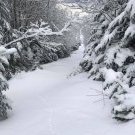
powderfreak Posted January 7, 2020 Share Posted January 7, 2020 Haven't posted some photos in a while... here's the past two days on Mansfield: 4 Link to comment Share on other sites More sharing options...
Sugarloaf1989 Posted January 7, 2020 Share Posted January 7, 2020 On 1/6/2020 at 5:44 PM, MarkO said: I skied in Summer ski camp in Europe in July of 1985. I skied at Stubai, Austria, Zermatt, Switzerland, Tignes, France and ValSenales, Italy. Currently the only area still offering skiing all Summer is Zermatt. The other areas don't have enough snow cover remaining on their glacier's past August 1st to allow for skiing all Summer. Global warming might be increasing the precipitation, but Summer snow levels are higher, with rain falling on glacial ice. Link to comment Share on other sites More sharing options...
snowgeek Posted January 10, 2020 Share Posted January 10, 2020 Haven't posted some photos in a while... here's the past two days on Mansfield:Great pics!! It’s amazing how a good skier and photographer can make any powder look super deep. . Link to comment Share on other sites More sharing options...
snowgeek Posted January 10, 2020 Share Posted January 10, 2020 Thinking of going to Killington our Pico Saturday. They got lots of snow this week and seemed to get the upslope bullseye. Killington is about 90% open and Pico 100%. Worried about rain and fog. Also worried that snow might be wet and sticky. Seems like when it’s powdery and then gets warm, the snow can be weird. Needs a few freezes and thaws to turn into nice corn. . Link to comment Share on other sites More sharing options...
snowgeek Posted January 10, 2020 Share Posted January 10, 2020 I skied in Summer ski camp in Europe in July of 1985. I skied at Stubai, Austria, Zermatt, Switzerland, Tignes, France and ValSenales, Italy. Currently the only area still offering skiing all Summer is Zermatt. The other areas don't have enough snow cover remaining on their glacier's past August 1st to allow for skiing all Summer. Global warming might be increasing the precipitation, but Summer snow levels are higher, with rain falling on glacial ice.That sounds so cool! I agree that some areas might see more snow fall for a while but I think the pack will suffer with more rain and warm temps too. Sad. . Link to comment Share on other sites More sharing options...
snowgeek Posted January 10, 2020 Share Posted January 10, 2020 Looks a bit windy tomorrow. NWS going for gust to 75 on Killington Peak. . Link to comment Share on other sites More sharing options...
ORH_wxman Posted January 10, 2020 Share Posted January 10, 2020 4 hours ago, snowgeek said: Looks a bit windy tomorrow. NWS going for gust to 75 on Killington Peak. . 65 knots at 850mb and about 50 knots at 925mb....so yeah, def some big gusts up there tomorrow. Link to comment Share on other sites More sharing options...
powderfreak Posted January 10, 2020 Share Posted January 10, 2020 17 hours ago, snowgeek said: Great pics!! It’s amazing how a good skier and photographer can make any powder look super deep. . Most of that was untouched from this week’s snow... so they are turning in about 12-18” of consolidated powder. Plenty deep! We just finished a nice run of 19” in 5 days. Hunt the untracked and it skied like over a foot. But yeah, the speed at which these guys ski the woods is what makes photos. Fluffy snow and high rates of speed make that stuff explode. 1 Link to comment Share on other sites More sharing options...
snowgeek Posted January 10, 2020 Share Posted January 10, 2020 37 minutes ago, powderfreak said: Most of that was untouched from this week’s snow... so they are turning in about 12-18” of consolidated powder. Plenty deep! We just finished a nice run of 19” in 5 days. Hunt the untracked and it skied like over a foot. But yeah, the speed at which these guys ski the woods is what makes photos. Fluffy snow and high rates of speed make that stuff explode. I'm thinking tomorrow may not be worth the trip to Killington. If I knew it would ski like a nice spring day, I'd go, but I'm thinking rainy, windy, foggy, drizzly with sticky snow. I don't mind getting a little wet, but tomorrow looks pretty nasty. Thoughts? Link to comment Share on other sites More sharing options...
snowgeek Posted January 10, 2020 Share Posted January 10, 2020 Mt. Bachelors forecast! My son is going this weekend. I'll be out there in February. Stoked! This Afternoon Snow. Temperature falling to around 21 by 5pm. Breezy, with a southwest wind 23 to 28 mph, with gusts as high as 41 mph. Chance of precipitation is 100%. Total daytime snow accumulation of 4 to 8 inches possible. Tonight Snow. Steady temperature around 19. Wind chill values as low as -1. Windy, with a west wind 30 to 32 mph, with gusts as high as 47 mph. Chance of precipitation is 100%. New snow accumulation of 11 to 17 inches possible. Saturday Snow. Areas of blowing snow after 10am. Temperature rising to near 23 by 10am, then falling to around 15 during the remainder of the day. Wind chill values as low as -5. Breezy, with a west wind 26 to 28 mph, with gusts as high as 38 mph. Chance of precipitation is 100%. New snow accumulation of 8 to 12 inches possible. Saturday Night Snow. Low around 17. Wind chill values as low as -4. Windy, with a west wind around 31 mph, with gusts as high as 44 mph. Chance of precipitation is 90%. New snow accumulation of 7 to 11 inches possible. Sunday Snow. High near 22. Windy, with a west wind 26 to 31 mph, with gusts as high as 44 mph. Chance of precipitation is 100%. New snow accumulation of 9 to 13 inches possible. Sunday Night Snow. Low around 12. Windy. Chance of precipitation is 100%. New snow accumulation of 10 to 14 inches possible. Monday Snow. High near 17. Breezy. Chance of precipitation is 100%. New snow accumulation of 9 to 13 inches possible. Link to comment Share on other sites More sharing options...
ORH_wxman Posted January 10, 2020 Share Posted January 10, 2020 4 minutes ago, snowgeek said: Mt. Bachelors forecast! My son is going this weekend. I'll be out there in February. Stoked! This Afternoon Snow. Temperature falling to around 21 by 5pm. Breezy, with a southwest wind 23 to 28 mph, with gusts as high as 41 mph. Chance of precipitation is 100%. Total daytime snow accumulation of 4 to 8 inches possible. Tonight Snow. Steady temperature around 19. Wind chill values as low as -1. Windy, with a west wind 30 to 32 mph, with gusts as high as 47 mph. Chance of precipitation is 100%. New snow accumulation of 11 to 17 inches possible. Saturday Snow. Areas of blowing snow after 10am. Temperature rising to near 23 by 10am, then falling to around 15 during the remainder of the day. Wind chill values as low as -5. Breezy, with a west wind 26 to 28 mph, with gusts as high as 38 mph. Chance of precipitation is 100%. New snow accumulation of 8 to 12 inches possible. Saturday Night Snow. Low around 17. Wind chill values as low as -4. Windy, with a west wind around 31 mph, with gusts as high as 44 mph. Chance of precipitation is 90%. New snow accumulation of 7 to 11 inches possible. Sunday Snow. High near 22. Windy, with a west wind 26 to 31 mph, with gusts as high as 44 mph. Chance of precipitation is 100%. New snow accumulation of 9 to 13 inches possible. Sunday Night Snow. Low around 12. Windy. Chance of precipitation is 100%. New snow accumulation of 10 to 14 inches possible. Monday Snow. High near 17. Breezy. Chance of precipitation is 100%. New snow accumulation of 9 to 13 inches possible. Some pretty cold systems moving into the PAC NW....definitely not Cascade Concrete in those storms. Link to comment Share on other sites More sharing options...
bwt3650 Posted January 10, 2020 Share Posted January 10, 2020 14 minutes ago, snowgeek said: I'm thinking tomorrow may not be worth the trip to Killington. If I knew it would ski like a nice spring day, I'd go, but I'm thinking rainy, windy, foggy, drizzly with sticky snow. I don't mind getting a little wet, but tomorrow looks pretty nasty. Thoughts? Jay put on their snow report to basically, stay home this weekend. They all but guarantee any upper mountain lift will be on wind hold and don’t expect this weeks conditions (like pf is posting from Stowe). I would expect the same all over Vt. Killington, Stowe and jay did really well this week so I don’t think this weekend’s crap will be a total wipeout. They should recover quickly and next weekend looks better. 1 Link to comment Share on other sites More sharing options...
snowgeek Posted January 10, 2020 Share Posted January 10, 2020 Some pretty cold systems moving into the PAC NW....definitely not Cascade Concrete in those storms.Bachelor is on the eastern slope of the cascades, so they get some pretty good powder. Mt. Hood snow is usually much wetter. . Link to comment Share on other sites More sharing options...
HIPPYVALLEY Posted January 10, 2020 Share Posted January 10, 2020 1 hour ago, snowgeek said: Mt. Bachelors forecast! My son is going this weekend. I'll be out there in February. Stoked! This Afternoon Snow. Temperature falling to around 21 by 5pm. Breezy, with a southwest wind 23 to 28 mph, with gusts as high as 41 mph. Chance of precipitation is 100%. Total daytime snow accumulation of 4 to 8 inches possible. Tonight Snow. Steady temperature around 19. Wind chill values as low as -1. Windy, with a west wind 30 to 32 mph, with gusts as high as 47 mph. Chance of precipitation is 100%. New snow accumulation of 11 to 17 inches possible. Saturday Snow. Areas of blowing snow after 10am. Temperature rising to near 23 by 10am, then falling to around 15 during the remainder of the day. Wind chill values as low as -5. Breezy, with a west wind 26 to 28 mph, with gusts as high as 38 mph. Chance of precipitation is 100%. New snow accumulation of 8 to 12 inches possible. Saturday Night Snow. Low around 17. Wind chill values as low as -4. Windy, with a west wind around 31 mph, with gusts as high as 44 mph. Chance of precipitation is 90%. New snow accumulation of 7 to 11 inches possible. Sunday Snow. High near 22. Windy, with a west wind 26 to 31 mph, with gusts as high as 44 mph. Chance of precipitation is 100%. New snow accumulation of 9 to 13 inches possible. Sunday Night Snow. Low around 12. Windy. Chance of precipitation is 100%. New snow accumulation of 10 to 14 inches possible. Monday Snow. High near 17. Breezy. Chance of precipitation is 100%. New snow accumulation of 9 to 13 inches possible. Lol, that's like 60" in 5 days. Link to comment Share on other sites More sharing options...
snowgeek Posted January 10, 2020 Share Posted January 10, 2020 Lol, that's like 60" in 5 days.I know, right!! They’re behind this year. Only at 107”. . Link to comment Share on other sites More sharing options...
Hitman Posted January 11, 2020 Share Posted January 11, 2020 4 hours ago, snowgeek said: I know, right!! They’re behind this year. Only at 107”. . I’m going to whitewater in a month. They have a settled snowpack of 95”. Link to comment Share on other sites More sharing options...
snowgeek Posted January 11, 2020 Share Posted January 11, 2020 I’m going to whitewater in a month. They have a settled snowpack of 95”. Cool video! Whitewater is on my bucket list. . Link to comment Share on other sites More sharing options...
Hitman Posted January 11, 2020 Share Posted January 11, 2020 7 hours ago, snowgeek said: Cool video! Whitewater is on my bucket list. . Pia to get to but if you’re into snow, prefer it dry and don’t need to stay on the mountain, it’s great. If u need any info, pm me. This will be my 6th trip to Nelson. Link to comment Share on other sites More sharing options...

Recommended Posts
Create an account or sign in to comment
You need to be a member in order to leave a comment
Create an account
Sign up for a new account in our community. It's easy!
Register a new accountSign in
Already have an account? Sign in here.
Sign In Now