SnowGoose69 Posted October 29, 2012 Share Posted October 29, 2012 upton disagrees....they think strongest gusts occur when winds switch to S-SE after landfall. Bill G on at Upton pointed that out to me this morning in another thread. I had not noticed it before that but definitely as I posted a bit earlier thats a potentially troublesome period this evening. The soundings are much more unstable but again less rain and darkness perhaps could help...could. Link to comment Share on other sites More sharing options...
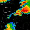
Metsfan Posted October 29, 2012 Share Posted October 29, 2012 Looks like shes going to make landfall around Cape May. Link to comment Share on other sites More sharing options...
MJO812 Posted October 29, 2012 Share Posted October 29, 2012 Looks like a hurricane here in Colts Neck. Tremendous roaring of the trees right now. Gusted to 46mph thus far. Same here. Gusts over 60 mph. that is an area where the storm isnt underforming . What were you expecting from this storm? A lot of areas are getting it hard right now. The strongest winds are yet to come. Link to comment Share on other sites More sharing options...
dbc Posted October 29, 2012 Share Posted October 29, 2012 ALL NWP IN PRETTY CLOSE AGREEMENT ON DEVELOPMENT AND PLACEMENT OF A BAND OF VERY STRONG 925 MB WINDS OF 70-90 KT TO THE NORTH OF THE CYCLONE BY LATE AFTERNOON OVER OUR CWA...ESPECIALLY ACROSS COASTAL SECTIONS. A SHALLOW MIXED LAYER BELOW THAT...IN COMBINATION WITH POSSIBLE GRAVITY WAVE DUCTING JUST NORTH OF A WARM FRONT DEVELOPING TO THE NORTHEAST OF SANDY...COULD ALLOW A LARGE PORTION OF THESE STRONG WINDS TO MIX DOWN...ESPECIALLY IN HEAVIER RAIN...SO AT LEAST OCCASIONAL GUSTS 60-75 MPH EXPECTED IN NE-E FLOW DURING MID TO LATE AFTERNOON BEFORE THE STORM MAKES LANDFALL. OF EVEN GREATER CONCERN IS A SECOND BAND OF FCST 925 MB WINDS OF SIMILAR STRENGTH ON THE SE FLANK OF THE CYCLONE THAT SHOULD ROTATE UP INTO THE CWA DURING AND JUST AFTER LANDFALL THIS EVENING...INITIALLY IMPACTING SOUTHERN CT AND LONG ISLAND...THEN TRANSLATING WESTWARD INTO NYC METRO AND THE LOWER HUDSON VALLEY. STEEPENING LOW LEVEL LAPSE RATES IN THIS QUADRANT OF THE STORM AS CAA BEGINS JUST OFF THE DECK...BUT AS LOW LEVEL WAA CONTINUES...SHOULD LEAD TO EVEN MORE EFFICIENT MOMENTUM TRANSFER...WITH THE STRONGEST WINDS EXPECTED ALONG THE SOUTH SHORES OF LONG ISLAND AND CT WHERE WINDS COULD GUST 80 TO PERHAPS 90 MPH. THERE MAY BE A LOW END TORNADO THREAT ACROSS EASTERN CT/LONG ISLAND DURING THIS TIME VIA STRONG LOW LEVEL HELICITY AND DEVELOPMENT OF MARGINAL LOW LEVEL CAPE...NOT ENOUGH FOR THUNDER INITIALLY BUT ENOUGH FOR LOW-TOPPED CONVECTION THAT COULD STRETCH ROTATING UPDRAFTS AND/OR TAP INTO HIGHER MOMENTUM ALOFT. This is why people crying bust are in for a reality check. Link to comment Share on other sites More sharing options...
Dosh Posted October 29, 2012 Share Posted October 29, 2012 ALL NWP IN PRETTY CLOSE AGREEMENT ON DEVELOPMENT AND PLACEMENT OF A BAND OF VERY STRONG 925 MB WINDS OF 70-90 KT TO THE NORTH OF THE CYCLONE BY LATE AFTERNOON OVER OUR CWA...ESPECIALLY ACROSS COASTAL SECTIONS. A SHALLOW MIXED LAYER BELOW THAT...IN COMBINATION WITH POSSIBLE GRAVITY WAVE DUCTING JUST NORTH OF A WARM FRONT DEVELOPING TO THE NORTHEAST OF SANDY...COULD ALLOW A LARGE PORTION OF THESE STRONG WINDS TO MIX DOWN...ESPECIALLY IN HEAVIER RAIN...SO AT LEAST OCCASIONAL GUSTS 60-75 MPH EXPECTED IN NE-E FLOW DURING MID TO LATE AFTERNOON BEFORE THE STORM MAKES LANDFALL. OF EVEN GREATER CONCERN IS A SECOND BAND OF FCST 925 MB WINDS OF SIMILAR STRENGTH ON THE SE FLANK OF THE CYCLONE THAT SHOULD ROTATE UP INTO THE CWA DURING AND JUST AFTER LANDFALL THIS EVENING...INITIALLY IMPACTING SOUTHERN CT AND LONG ISLAND...THEN TRANSLATING WESTWARD INTO NYC METRO AND THE LOWER HUDSON VALLEY. STEEPENING LOW LEVEL LAPSE RATES IN THIS QUADRANT OF THE STORM AS CAA BEGINS JUST OFF THE DECK...BUT AS LOW LEVEL WAA CONTINUES...SHOULD LEAD TO EVEN MORE EFFICIENT MOMENTUM TRANSFER...WITH THE STRONGEST WINDS EXPECTED ALONG THE SOUTH SHORES OF LONG ISLAND AND CT WHERE WINDS COULD GUST 80 TO PERHAPS 90 MPH. THERE MAY BE A LOW END TORNADO THREAT ACROSS EASTERN CT/LONG ISLAND DURING THIS TIME VIA STRONG LOW LEVEL HELICITY AND DEVELOPMENT OF MARGINAL LOW LEVEL CAPE...NOT ENOUGH FOR THUNDER INITIALLY BUT ENOUGH FOR LOW-TOPPED CONVECTION THAT COULD STRETCH ROTATING UPDRAFTS AND/OR TAP INTO HIGHER MOMENTUM ALOFT. Until we get some honest rain bands set up I have a hard time believing this LLJ hype. it hasn't happened in past noreasters where we've been promised hurricane force winds. Also I'd like to add first hurricane force wind gust in NJ at Harvey Cedars at 3:55 with a 75mph gust. Link to comment Share on other sites More sharing options...
KEITH L.I Posted October 29, 2012 Share Posted October 29, 2012 200,000 out on Long Island..and it's not over yet Link to comment Share on other sites More sharing options...
bluewave Posted October 29, 2012 Share Posted October 29, 2012 any chance you can explain what mechanism will mix those winds down to the surface? much appreciated. CAA from the SE as colder air begins to wrap all the way around the center. Link to comment Share on other sites More sharing options...
earthlight Posted October 29, 2012 Share Posted October 29, 2012 Looks like shes going to make landfall around Cape May. Not a bad estimate..maybe a little north of there...but contrary to the belief of some posters it has little to no effect on what happens in NYC whether she makes landfall in ACY or a little south of there. Link to comment Share on other sites More sharing options...
ace0927 Posted October 29, 2012 Share Posted October 29, 2012 This is why people crying bust are in for a reality check. i dont think a lot of people are crying bust. However, people might be saying its not as bad as they expected ITBY's... Link to comment Share on other sites More sharing options...
Paweatherguy1 Posted October 29, 2012 Share Posted October 29, 2012 Please, stop. I'm on a phone so I can't report you, but I'll take the word of trained mets over you. Until we get some honest rain bands set up I have a hard time believing this LLJ hype. it hasn't happened in past noreasters where we've been promised hurricane force winds. Also I'd like to add first hurricane force wind gust in NJ at Harvey Cedars at 3:55 with a 75mph gust. Link to comment Share on other sites More sharing options...
SnowGoose69 Posted October 29, 2012 Share Posted October 29, 2012 200,000 out on Long Island..and it's not over yet I had estimated 1.5 might go...hopefully thats out of reach now, could probably still get 600-800 though. Link to comment Share on other sites More sharing options...
ARyan Posted October 29, 2012 Share Posted October 29, 2012 Somebody in my neighborhood has their wood chipper out. Wasting no time cleaning up...before the worst of the storm is here. Link to comment Share on other sites More sharing options...
earthlight Posted October 29, 2012 Share Posted October 29, 2012 From okx on social media: Some hurricane force wind gusts being reported near the Long Island coast. 81 MPH at Plum Island and 74 MPH at Eatons Neck. A 70 MPH wind gust was recently reported at Groton, CT and Stonington, CT. Expect these wind gusts to continue and also increase across Long Island, southern Connecticut, NYC, NE NJ and the Lower Hudson Valley. Link to comment Share on other sites More sharing options...
Drz1111 Posted October 29, 2012 Share Posted October 29, 2012 i dont think a lot of people are crying bust. However, people might be saying its not as bad as they expected ITBY's... That says more about the person than it does about the storm. Link to comment Share on other sites More sharing options...
MJO812 Posted October 29, 2012 Share Posted October 29, 2012 Upton has 40-50 mph sustained winds tonight with gusts up to 80 for my area Link to comment Share on other sites More sharing options...
EasternLI Posted October 29, 2012 Share Posted October 29, 2012 Rocking out here right now. Winds still seemingly on the increase. Also, flooding from peconic river up to main street in riverhead. Link to comment Share on other sites More sharing options...
ag3 Posted October 29, 2012 Share Posted October 29, 2012 Not a bad estimate..maybe a little north of there...but contrary to the belief of some posters it has little to no effect on what happens in NYC whether she makes landfall in ACY or a little south of there. It does with rain John. If the landfall was up towards Sandy Hook, like models has a couple days ago, we would've had the rain as well. Link to comment Share on other sites More sharing options...
earthlight Posted October 29, 2012 Share Posted October 29, 2012 It does with rain John. If the landfall was up towards Sandy Hook, like models has a couple days ago, we would've had the rain as well. Everyone and their mother knew the best rain was on the southwest side of the system. Link to comment Share on other sites More sharing options...
NorthNJwx Posted October 29, 2012 Share Posted October 29, 2012 Peak gust of 64 mph at my LBI station - amazing! Also have had gusts to 40 now in my deep-valley location here in NNJ. This is the real deal. Link to comment Share on other sites More sharing options...
SACRUS Posted October 29, 2012 Share Posted October 29, 2012 Thank you....Ditto in my area. I dont think ive seen, heard, felt anything near 60MPH gusts...there arent even branches down here... I think its too early to say this before the evening. Picking up here big time and power outagesd are growing. The surge is starting to build into NY Harbor. The harbor is in condition zulu (closed) till wed morning the earliest Link to comment Share on other sites More sharing options...
NorEaster27 Posted October 29, 2012 Share Posted October 29, 2012 Not a bad estimate..maybe a little north of there...but contrary to the belief of some posters it has little to no effect on what happens in NYC whether she makes landfall in ACY or a little south of there. 100 percent disagree, if it made landfall in sandy hook vs cape may its a world of difference in sensible weather for NYC Link to comment Share on other sites More sharing options...
ag3 Posted October 29, 2012 Share Posted October 29, 2012 Everyone and their mother knew the best rain was on the southwest side of the system. Of course. But a landfall near Sandy Hook, would've bought 4"+ in our area. Link to comment Share on other sites More sharing options...
earthlight Posted October 29, 2012 Share Posted October 29, 2012 SREFs just went bonkers with sustained 10m winds after the SE wind shift...over 50mph on many models and the mean between 40 and 50 mph. Terrible news for mostly everyone given the soundings showing better ability to mix and momentum transfer...and the timing of these southeast gales into NY Harbor and S Long Island at high tide. Link to comment Share on other sites More sharing options...
cjr231 Posted October 29, 2012 Share Posted October 29, 2012 My neighbors roof is destroyed. Unbelievable. I took video of it blowing apart in the wind. Not sure how to post here. Link to comment Share on other sites More sharing options...
earthlight Posted October 29, 2012 Share Posted October 29, 2012 100 percent disagree, if it made landfall in sandy hook vs cape may its a world of difference in sensible weather for NYC Who said anything about Sandy Hook? Models have been near LBI or south since yesterday. Link to comment Share on other sites More sharing options...
blizzardof09 Posted October 29, 2012 Share Posted October 29, 2012 about to lose power i will say this winds have really starting ripping good id say close to hurricane force and got a bunch of good size limbs coming down as well. really looking forward to the winds getting going in an hour or two Link to comment Share on other sites More sharing options...
MJO812 Posted October 29, 2012 Share Posted October 29, 2012 My lights just dimmed Link to comment Share on other sites More sharing options...
Sampson Posted October 29, 2012 Share Posted October 29, 2012 i dont think a lot of people are crying bust. However, people might be saying its not as bad as they expected ITBY's... It's not a bust IMBY. Link to comment Share on other sites More sharing options...
blizzardof09 Posted October 29, 2012 Share Posted October 29, 2012 @noreaster27-earthlight to me is one of the better mets in our subforum and hold his word very highly i wouldnt be doubting him when he says/posts stuff. btw, earthlight that is 50-55kt sustained correct? with higher gusts right? Link to comment Share on other sites More sharing options...
earthlight Posted October 29, 2012 Share Posted October 29, 2012 , earthlight that is 50-55kt sustained correct? with higher gusts right? mph not kts. Link to comment Share on other sites More sharing options...

Recommended Posts
Archived
This topic is now archived and is closed to further replies.