Arnold214 Posted December 9, 2010 Share Posted December 9, 2010 I find it almost impossible that a player with his power only hit 6 HRs last year...that is incredible to me. They must be putting something in the water at Citifield. And it goes with them on the road. He'll bounce back I'm sure. But that was about as brutal as a year as you could ever envision from a player like Bay. I wish it was 5 years ago today. edit: cut out from the Red Sox thread. Link to comment Share on other sites More sharing options...
ORH_wxman Posted December 9, 2010 Share Posted December 9, 2010 I wish it was 5 years ago today. I was just finishing the forecast for commando. Upped it from 4-7 to 8-12" with 12"+....cited the ETA/SREF mean and MM5 as all in agreement over the global models...it would go to town lunchtime and early afternoon. Despite that forecast and seemingly good call...it was too conservative and had no idea we'd see what happened for 3-4 hours in eastern MA/SE NH. Pretty amazing. I drove home to steady light snow around 430-5am as the onset came on us. Only about 3-4" accumulated between that time and about 1130am...who knew what would happen after that. Link to comment Share on other sites More sharing options...
Arnold214 Posted December 9, 2010 Author Share Posted December 9, 2010 I was just finishing the forecast for commando. Upped it from 4-7 to 8-12" with 12"+....cited the ETA/SREF mean and MM5 as all in agreement over the global models...it would go to town lunchtime and early afternoon. Despite that forecast and seemingly good call...it was too conservative and had no idea we'd see what happened for 3-4 hours in eastern MA/SE NH. Pretty amazing. I drove home to steady light snow around 430-5am as the onset came on us. Only about 3-4" accumulated between that time and about 1130am...who knew what would happen after that. I was sitting in my hotel room in needham having a few brewskis not having a clue what would transpire within 12 to 15 hours. Link to comment Share on other sites More sharing options...
ORH_wxman Posted December 9, 2010 Share Posted December 9, 2010 I was sitting in my hotel room in needham having a few brewskis not having a clue what would transpire within 12 to 15 hours. And you would eventually be basically ground zero for that band that developed about 12 hours from now. A thunderstorm with heavy snow was probably a better description vs heavy snow with thunder. Link to comment Share on other sites More sharing options...
dendrite Posted December 9, 2010 Share Posted December 9, 2010 And you would eventually be basically ground zero for that band that developed about 12 hours from now. A thunderstorm with heavy snow was probably a better description vs heavy snow with thunder. Grapefruit sized dendrites Link to comment Share on other sites More sharing options...
Arnold214 Posted December 9, 2010 Author Share Posted December 9, 2010 And you would eventually be basically ground zero for that band that developed about 12 hours from now. A thunderstorm with heavy snow was probably a better description vs heavy snow with thunder. I've always described it as an MCS with snow...that's exactly what it was. Link to comment Share on other sites More sharing options...
ORH_wxman Posted December 9, 2010 Share Posted December 9, 2010 Grapefruit sized dendrites That was probably better served for Dec 23, 1997. 12/9/05, the flakes were never that big...they just down poured like a thunderstorm. Esp where Mek was in Needham. They were still good dendrites, but more like the dime sized or slightly less in variety...even pea sized. They just poured down though with thunder. Link to comment Share on other sites More sharing options...
dendrite Posted December 9, 2010 Share Posted December 9, 2010 METAR KTAN 091952Z AUTO 30022G34KT M1/4SM +TSSN FZFG BKN001 OVC005 M01/M01 A2952 RMK AO2 PK WND 30040/1934 WSHFT 1844 LTG DSNT N AND NW TSB49RAE13SNB13 SLP996 P0028 T10061011 Link to comment Share on other sites More sharing options...
ORH_wxman Posted December 9, 2010 Share Posted December 9, 2010 METAR KTAN 091952Z AUTO 30022G34KT M1/4SM +TSSN FZFG BKN001 OVC005 M01/M01 A2952 RMK AO2 PK WND 30040/1934 WSHFT 1844 LTG DSNT N AND NW TSB49RAE13SNB13 SLP996 P0028 T10061011 Did OWD have a similar METAR? I think he was right near the TV towers along Rt 128. Right near the Needham/Newton/Wellsely triple point. That was basically a perfect spot to be. That area had several spotter reports of 12" in 3 hours. Link to comment Share on other sites More sharing options...
dendrite Posted December 9, 2010 Share Posted December 9, 2010 That was probably better served for Dec 23, 1997. 12/9/05, the flakes were never that big...they just down poured like a thunderstorm. Esp where Mek was in Needham. They were still good dendrites, but more like the dime sized or slightly less in variety. They just poured down though with thunder. Well I wasn't talking aggregates. I was in MHT for the storm and there was awesome dendritic growth with high ratios in that band. Maybe it was different down there. Link to comment Share on other sites More sharing options...
dendrite Posted December 9, 2010 Share Posted December 9, 2010 Did OWD have a similar METAR? I think he was right near the TV towers along Rt 128. Right near the Needham/Newton/Wellsely triple point. That was basically a perfect spot to be. That area had several spotter reports of 12" in 3 hours. This was probably the most impressive ob...METAR KOWD 091953Z 33021G30KT 1/4SM FZFG VV001 M02/M02 A2959 RMK AO2 PK WND 33034/1920 SNEMMB19SNEMM PRESRR SLP022 P0009 T10171022 $ Of course the precip sensor got snowed up and died, but it was pouring snow with that 1/4SM vis and 100ft ceiling. Link to comment Share on other sites More sharing options...
ORH_wxman Posted December 9, 2010 Share Posted December 9, 2010 Well I wasn't talking aggregates. I was in MHT for the storm and there was awesome dendritic growth with high ratios in that band. Maybe it was different down there. Yeah I bet up there it was more "ideal" for snow growth with better ratios. I remember that band actually killed the CON area and the suburbs near CON. I think there were reports of 17" (since we had clients in that area where I was working back then, we kept close tabs on them). Down just W of BOS and eventually in BOS itself, it was more of the smaller dendrites (with a few larger ones mixed in) that just poured down like a thunderstorm down pour. Wind was ferocious too with it. It was probably just chaos....for the best word to describe it. Brief, but total chaos. Link to comment Share on other sites More sharing options...
dendrite Posted December 9, 2010 Share Posted December 9, 2010 Yeah I bet up there it was more "ideal" for snow growth with better ratios. I remember that band actually killed the CON area and the suburbs near CON. I think there were reports of 17" (since we had clients in that area where I was working back then, we kept close tabs on them). Down just W of BOS and eventually in BOS itself, it was more of the smaller dendrites (with a few larger ones mixed in) that just poured down like a thunderstorm down pour. Wind was ferocious too with it. It was probably just chaos....for the best word to describe it. Brief, but total chaos. I had over 7" in 2hrs from that band. the radar image was my Eastern profile pic for like all 5 years. I'm not sure I even have it anymore. Link to comment Share on other sites More sharing options...
dendrite Posted December 9, 2010 Share Posted December 9, 2010 Link to comment Share on other sites More sharing options...
ORH_wxman Posted December 9, 2010 Share Posted December 9, 2010 It was brief but probably best described as a "shooting star"....it made its mark. Link to comment Share on other sites More sharing options...
ORH_wxman Posted December 9, 2010 Share Posted December 9, 2010 I'll def. never forget that storm and how quickly it transpired. I remember at 1130-12pm thinking it might be a bust and questioning the mesoscale models, but then all hell broke loose. It was so impressive seeing the band intensify and then the wind...the wind didn't affect my area as much as eastern and especially SE MA...but it was still 45-50mph even here for a very brief stint as the stratosphere tried to kiss the ground. Link to comment Share on other sites More sharing options...
Arnold214 Posted December 9, 2010 Author Share Posted December 9, 2010 Did OWD have a similar METAR? I think he was right near the TV towers along Rt 128. Right near the Needham/Newton/Wellsely triple point. That was basically a perfect spot to be. That area had several spotter reports of 12" in 3 hours. Yeah, it was the sheraton in Needham...the channel 5 towers were basically right behind the hotel. maybe 100-300 feet from the back of the hotel. Link to comment Share on other sites More sharing options...
ORH_wxman Posted December 9, 2010 Share Posted December 9, 2010 Yeah, it was the sheraton in Needham...the channel 5 towers were basically right behind the hotel. maybe 100-300 feet from the back of the hotel. I remember from the eastern thread and also BOX AFD/Short term forecast update....that area was getting killed. We had like 2 or 3 posters alone in a 5 mile radius of that area that all said they got 10-12" in 3 hours or less during the height of that.It was funny because they had like 2-3" before that but it got matted down by sleet and a rain/snow mix so they had very little when the band set up...just a dense 1" pack or even less if you were slightly east. Link to comment Share on other sites More sharing options...
dendrite Posted December 9, 2010 Share Posted December 9, 2010 I remember from the eastern thread and also BOX AFD/Short term forecast update....that area was getting killed. We had like 2 or 3 posters alone in a 5 mile radius of that area that all said they got 10-12" in 3 hours or less during the height of that.It was funny because they had like 2-3" before that but it got matted down by sleet and a rain/snow mix so they had very little when the band set up...just a dense 1" pack or even less if you were slightly east. Wasn't there like 3-4 posters that all posted they had thundersnow at once? Link to comment Share on other sites More sharing options...
Arnold214 Posted December 9, 2010 Author Share Posted December 9, 2010 I remember from the eastern thread and also BOX AFD/Short term forecast update....that area was getting killed. We had like 2 or 3 posters alone in a 5 mile radius of that area that all said they got 10-12" in 3 hours or less during the height of that.It was funny because they had like 2-3" before that but it got matted down by sleet and a rain/snow mix so they had very little when the band set up...just a dense 1" pack or even less if you were slightly east. yeah the storm was rather unimpressive up until the banding got going...I was rather disappointed around lunchtime when I was getting a snow/sleet mix if not just sleet. Then the banding really started to get going across western mass...and I was like "well, what do we have here?" lol Link to comment Share on other sites More sharing options...
Arnold214 Posted December 9, 2010 Author Share Posted December 9, 2010 Wasn't there like 3-4 posters that all posted they had thundersnow at once? there was so much damn lightning...unbelieveable. Link to comment Share on other sites More sharing options...
ORH_wxman Posted December 9, 2010 Share Posted December 9, 2010 Wasn't there like 3-4 posters that all posted they had thundersnow at once? I think it was more like 6 or 7, lol. That was just the first bout of thunder snow when it hit RI and the 128 belt initially...but then after that it was almost continuous thunder snow for 128 and inside that area. I'm sure Ek could tell you, I think he said it was like an MCS...just on and off thunder with heavy down pours for awhile...except it wasn't rain, it was snow...4-5" per hour in that area. After the posters reported thunder for the first time...they reported it again a couple times, but then it almost lost its luster, they said "there's another rumble of thunder, still snowing heavily"...stuff like that. I was definitely jealous, since I never got the thunder. We got the heavy snow, but I was too far west of the best dynamics to get the thunder. I think 500mb was trying to kiss the ground from the SW at the same time we had 80 knots from the SE at 850mb in that area. That region saw a fooking hole ripped in the atmosphere. Link to comment Share on other sites More sharing options...
Arnold214 Posted December 9, 2010 Author Share Posted December 9, 2010 I think it was more like 6 or 7, lol. That was just the first bout of thunder snow when it hit RI and the 128 belt initially...but then after that it was almost continuous thunder snow for 128 and inside that area. I'm sure Ek could tell you, I think he said it was like an MCS...just on and off thunder with heavy down pours for awhile...except it wasn't rain, it was snow...4-5" per hour in that area. After the posters reported thunder for the first time...they reported it again a couple times, but then it almost lost its luster, they said "there's another rumble of thunder, still snowing heavily"...stuff like that. I was definitely jealous, since I never got the thunder. We got the heavy snow, but I was too far west of the best dynamics to get the thunder. I think 500mb was trying to kiss the ground from the SW at the same time we had 80 knots from the SE at 850mb in that area. That region saw a fooking hole ripped in the atmosphere. The amount of lightning is definitely the #1 highlight. The other thing that doesn't get talked about too often was how fast it cleared out. It truly was like a thunderstorm in that respect. The heavy snow shut off like a faucet, the winds died off quickly, and the clearing line was impressively sharp. I'll never forget driving up over I-95 on the highland ave overpass...and just seeing crystal clear skies and the setting sun...like nothing ever happened except we had like 11" to a foot of new snow in a matter of 3 hours...and the traffic was snarled below on I-95...seemingly for no reason if you happened to sleep for those 3 hours. Link to comment Share on other sites More sharing options...
ORH_wxman Posted December 9, 2010 Share Posted December 9, 2010 The amount of lightning is definitely the #1 highlight. The other thing that doesn't get talked about too often was how fast it cleared out. It truly was like a thunderstorm in that respect. The heavy snow shut off like a faucet, the winds died off quickly, and the clearing line was impressively sharp. I'll never forget driving up over I-95 on the highland ave overpass...and just seeing crystal clear skies and the setting sun...like nothing ever happened except we had like 11" to a foot of new snow in a matter of 3 hours...and the traffic was snarled below on I-95...seemingly for no reason if you happened to sleep for those 3 hours. I remember seeing the sun set in that storm. The cloud line was literally that...a line. I remember seeing the line of overcast well to the east probably near BOS as the sun was dying below the horizon. edit: hearing the Highland overpass definitely brings images of 128 into my mind...all I can see if those TV towers. Link to comment Share on other sites More sharing options...
Arnold214 Posted December 9, 2010 Author Share Posted December 9, 2010 I remember seeing the sun set in that storm. The cloud line was literally that...a line. I remember seeing the line of overcast well to the east probably near BOS as the sun was dying below the horizon. edit: hearing the Highland overpass definitely brings images of 128 into my mind...all I I can see if those TV towers. The other vision I have engrained in my head from that event was looking out my 1st floor hotel window when s*** was starting to really hit the fan. Some guy was frantically trying to clear the snow off his car when lightning started to hit nearby...probably the tv tower behind the hotel. He looked up at the heavens like the world was about to end. Then I thought "yeah like that guy is gonna get anywhere". lol. Aside from watching the entire lifecycle of an F4 tornado, that storm was probably the most awesome display of mother nature I've ever seen. Just knowing the dynamics invloved...from the outrageous pressure falls and resultant increasingly screaming inflow SE of ack to the development of the mesoband. That was something else...it was like a freak high-end science project going on outside. Link to comment Share on other sites More sharing options...
ORH_wxman Posted December 9, 2010 Share Posted December 9, 2010 The other vision I have engrained in my head from that event was looking out my 1st floor hotel window when s*** was starting to really hit the fan. Some guy was frantically trying to clear the snow off his car when lightning started to hit nearby...probably the tv tower behind the hotel. He looked up at the heavens like the world was about to end. Then I thought "yeah like that guy is gonna get anywhere". lol. Aside from watching the entire lifecycle of an F4 tornado, that storm was probably the most awesome display of mother nature I've ever seen. Just knowing the dynamics invloved...from the increasingly screaming inflow SE of ack to the development of the mesoband. That was something else...it was like a freak high-end science project going on outside. Yeah I saw it all happen on radar. I wished I was further E in that storm even though I ended up with 13" of non-tainted snow. That was the one storm I probably wished I was further east despite that fact. When I was watching it unfolding on radar over my head, i was like "holy sh**" but then about 30-45 min later I wished I was further east. We got 4.5" in the final hour here, but I was in grave envy of those further east because of the thunder and lightning and the winds too. That might be one of the few coastal snowstorms where radar can make you wish you were closer to the center of the storm....seeing that inflow in the low levels on radar and the thunder reports. Then after Dave Vallee did the presentation at the 2006 SNE wx conference....he showed how 500mb basically kissed the earth surface in spots in SE MA on the cross section. Just amazing. Getting 85 knots out of like a 170 direction getting shoved to the sfc by a 16mb drop storm at the sfc in 3 hours. But it was so chaotic since the 85 knots were from 170 but the sfc winds were from like 340 or 350...the whole atmosphere was in pinwheel mode for a brief time there. Link to comment Share on other sites More sharing options...
Arnold214 Posted December 9, 2010 Author Share Posted December 9, 2010 Yeah I saw it all happen on radar. I wished I was further E in that storm even though I ended up with 13" of non-tainted snow. That was the one storm I probably wished I was further east despite that fact. When I was watching it unfolding on radar over my head, i was like "holy sh**" but then about 30-45 min later I wished I was further east. We got 4.5" in the final hour here, but I was in grave envy of those further east because of the thunder and lightning and the winds too. That might be one of the few coastal snowstorms where radar can make you wish you were closer to the center of the storm....seeing that inflow in the low levels on radar and the thunder reports. Then after Dave Vallee did the presentation at the 2006 SNE wx conference....he showed how 500mb basically kissed the earth surface in spots in SE MA on the cross section. Just amazing. Getting 85 knots out of like a 170 direction getting shoved to the sfc by a 16mb drop storm at the sfc in 3 hours. But it was so chaotic since the 85 knots were from 170 but the sfc winds were from like 340 or 350...the whole atmosphere was in pinwheel mode for a brief time there. yeah, buzzards bay tower went from 1003mb at 17z to 993mb at 18z. Talk about ripping a hole in the atmosphere. Link to comment Share on other sites More sharing options...
ORH_wxman Posted December 9, 2010 Share Posted December 9, 2010 yeah, buzzards bay tower went from 1003mb at 17z to 993mb at 18z. Talk about ripping a hole in the atmosphere. Thats incredible...they were ground zero for the low track too. The 16mb in 3 hours comes from ACK or somewhere near it via BOX AFD back then. They said ACK (or somewhere near since I'm not sure on the exact quote) dumped 16mb in 3 hours...but ACK was well east of the low track..it tracked basically over buzzards bay and into Cape Cod Bay. That will put a dent into people's mind about how a CC Canal track can't give E MA much snow. Link to comment Share on other sites More sharing options...
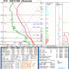
Arnold214 Posted December 9, 2010 Author Share Posted December 9, 2010 Thats incredible...they were ground zero for the low track too. The 16mb in 3 hours comes from ACK or somewhere near it via BOX AFD back then. They said ACK (or somewhere near since I'm not sure on the exact quote) dumped 16mb in 3 hours...but ACK was well east of the low track..it tracked basically over buzzards bay and into Cape Cod Bay. That will put a dent into people's mind about how a CC Canal track can't give E MA much snow. Here's the data from buzzards bay tower. starting at 13z going through 21z. winds are in m/s. Link to comment Share on other sites More sharing options...
ORH_wxman Posted December 9, 2010 Share Posted December 9, 2010 So they dumped nearly 20mb in 3 hours...nice. That's almost impossible to duplicate. The 10mb in 1 hour (they probably lost most of that in much less time) might be only be duplicatable in a very intense compact hurricane or a near TOR center. I think we know where the atmosphere loss most of its mass based on that obs sequence. What an incredible compact super bomb that was. Link to comment Share on other sites More sharing options...

Recommended Posts
Archived
This topic is now archived and is closed to further replies.