Search the Community
Showing results for tags 'thunderstorms'.
Found 14 results
-
It's early, but might as well do the annual severe thread (people were talking about it in the long range thread!). I don't have the @WxWatcher007 scale handy on this computer - but I usually post it for posterity for the upcoming severe season. Anything from discussing past events to potential upcoming patterns/analogs, and discussion about more specific upcoming threats can be posted in here. A while ago we stopped doing event-specific severe threads for most things. Whether we do that or not - this is the general thread. Have at it!
- 235 replies
-
- 3
-

-
- severe
- thunderstorms
- (and 5 more)
-
More heat, humidity and thunderstorms?? Go!
-
Now the dreaded season (for me) is upon us. Heat, storms, flooding and waiting on that first cold front in September to arrive and seeing those first lows in the 40s. I don't know what the summer will bring, but we know it will be hot and humid. Severe season is already off to a bad start with the tornado outbreak that spurred a lot of fatalities last week. I know it can't be avoided but I hope we don't have any more this spring.
- 295 replies
-
- 4
-
-

-
- severe weather
- frosts
- (and 5 more)
-
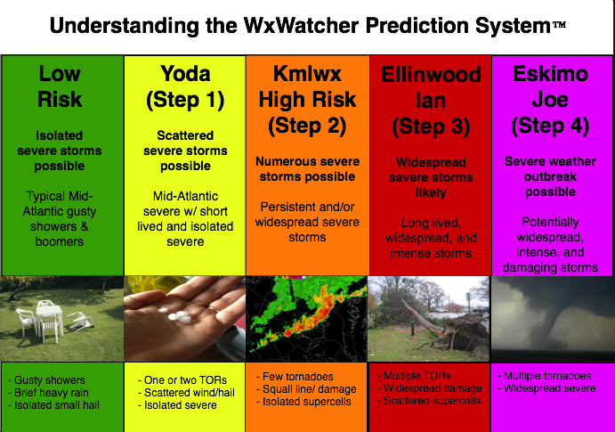
Given that there is a tiny chance at something next week, we'll go ahead and open up the 2023 iteration of the thread. I doubt it will amount to much of anything (perhaps a better chance in the Carolinas and far SEVA) but we'll see. General mid to long range discussion can go in here, as can discussion about past events etc. In past years this has also served as a bit of an "on the fly" obs thread for events that are too small to warrant a separate thread. Pretty casual rules in this annual thread. Looking forward to our usual folks And as always - attached is the @WxWatcher007 tier system for our severe threats here in the Mid-Atlantic subforum.
- 2,790 replies
-
- 9
-
-
-
- severe
- thunderstorms
- (and 3 more)
-
 Meteorological Spring hits March 1st, thus begins the quiet season on the forums. This thread should suffice until fall for any long range disco. I doubt the last flakes have fallen this year but I don't really expect another widespread winter threat either. It was definitely a Plateau to Western Tennessee winter. Tough for Eastern areas not to do any better with virtually the entire month of January being BN for temps. The flood threat, as it always seems to be these days, is definitely elevated again this spring. The severe threat, I'll leave that to Jeff, Jax, and the rest of the severe gurus.
 -
 We're turning this into the TIMS thread. Thunder in the mountains model? Can it equal snow afterwards? If so, does severe weather = heavier snow? We'll know by January 3rd, lol.
 -
 SPC continues Marginal risk se NYS-NJ. 00z-06z/20 HRRR/NAM/EC have decent development Wednesday afternoon. TT near 53 flag attention for hail and gust transfer looks like 40-45KT. Follow NWS local offices/SPC/and our own members assessments. Have added the SPC discussion plus the EC (just below SPC)/GFS (below EC) fcst sounding for 18z/21 n central NJ as an idea of what seems to be coming via convection for NJ. CAPE is marginal and KI OK. Activity while still fairly strong crossing LI/CT will ingest cooler southerly inflow from the ocean to limit potential hailers/wind gusts? Even so, the wind shift with significant cold air advection during the evening may induce isolated gusts 40 kt on the island? Have a look. This thread should also serve well for any significant reports of whatever convection occurs Wednesday afternoon.
 -
It's March...and even though we probably have a few more winter weather threats ahead...it's time to launch the 2019 Mid-Atlantic Severe Wx thread. Pattern stuff can go in here, discussion leading up to events and more. Same guidelines as past years. Thread will probably idle for a month or two - let's hope for some general excitement this year.
- 2,802 replies
-
- 2
-
-
- severe
- thunderstorms
- (and 4 more)
-
I remember be very young and already having a strong interest in thunderstorms, severe weather and winter storms. However it was a storm in the summer of 1993 that really elevated my obsession. It was a sweltering hot day and I was at an indoor gym and pool in central Suffolk county Long Island. All the sudden a dark line of clouds with frequent cloud to ground lightning blew across the sky and flash bang lightning and thunder started. The pool was evacuated and I walked over to the windows and saw torrential rain, pea sized hail and very strong wind gusts. The light poles were swaying violently and the wind gusts were reportedly over 50 mph. Due to historical weather data I think I am able to narrow this storm down to Saturday, July 10, 1993. I remember the radar showing very isolated cells near nyc and central Long Island. Also I think remember the news saying someone on Long Island was struck by lightning in this storm. Unfortunately the historical radar data from GIS only goes back to 1995 so I can’t confirm the exact date for sure. I know it’s a long shot but was wondering if anyone else here had any memory of this storm. Growing up on Long Island it was very frustrating getting severe storms due to the stabilizing marine influence, but this storm stuck out to me as short lived/isolated but very intense. I attended the Long Island philharmonic in heckscher Park that night with my family and I remember even the conductor mentioned the storm as being crazy. Also please feel free to share details of any storm that sparked your interest in weather.
-
New thead needed.
-
It is 41 in Kingsport with a windchill of 31. Wind chills are forecast tonight to be in the upper teens to lower 20s. Snow advisories are still posted for mountain communities. Still feels like winter, but spring temps are back in the forecast for this weekend.
-
Since we are taking a brief hiatus from winter for the next period of time...and since there is some small instability and good shear available tomorrow (see SPC discussion for day 2) - I figured we'd get a super early start on our 2018 Mid-Atlantic Severe Wx thread. Let's see how badly we can fail this year with storms splitting around DC, storms missing the area entirely, and our typical gusty showers from a pencil thin line. As bad as winter weenies are around here - I think our severe weather folks are even more desperate Ready? Go.
-
I have been really slacking as of late on the blogging ... hoping to fix that! Mediocre line of storms developed over the central Shenandoah Valley this afternoon and prompted a local blue box from Sterling around Charlottesville. There was a single report of wind damage in the city limits as well ... so congrats Sterling on the verification. Another line of storms lies further west from west-central Illinois through IND and down into LEX/central Kentucky ... high level blow off from this activity will likely stay clear of the area in at least the near term and allow for good rapid west to east clearing this evening. The clear skies early, excess moisture, and generally light winds will set the stage for some patchy overnight and early morning fog in areas that saw rain this afternoon (mainly the KSHD/KCHO area). This is not really anything new as this general area has seen patchy fog the last several mornings.
-
Hail can be a weather enthusiast delight during the Summer time (perhaps it reminds them of snow?). Unfortunately, forecasting hail size can be a bit of challenge. One method that I use is VIL Of the Day (VOTD). It was developed by the NWS back in the 90s. It purely relies on temperatures aloft and while simple, does a surprisingly good job. Obviously there are some limitations, but I will get to those in a minute. The calculation is straight forward and is as follows: VOTD = 750 / [(h5T+h4T) / 2] where h5T and h4T are the absolute values of the 500mb and 400mb temperatures respectively. The VIL value given from this equation is the approximate value at which you can expect 0.75” diameter hail stones to fall. 0.75” was chosen because this used to be the hail criteria for a severe thunderstorm. For operational purposes, the lower the expected VOTD the higher the large hail potential you can expect. I like to use 40 g/m^2 as a rough baseline in the Summer time. For those that are not familiar with VIL (Vertically Integrated Liquid), it is a radar product that operational meteorologists use to locate areas of heavy precipitation and hail. It is available in real time in all GR-LevelX products and some places on the internet (Weather Underground, etc). See the wiki page for a brief overview. Now back to the limitations of the VOTD approximation. It is best used for regular thunderstorms and not those with established mesocyclones (i.e. supercells) … although honestly it still works fairly well on most supercells we see around here. In storms with well-organized and established mesocyclones, there are additional mesoscale lifting mechanisms at work that can work to produce huge hail more efficiently than what you would tend to find in your average non-supercellular severe thunderstorm. Keep in mind that the VOTD can change as the thermal profile aloft changes. Check forecast soundings (remember, there is more than 1 model) for the afternoon ahead instead of relying solely on the 12z observed soundings. Lastly, VOTD gives you the VIL value for 0.75” hail stones and tells you nothing about maximum hailstone size, etc. I have attached a calculator that I wrote to help me compute VOTD quickly. I wrote it a while back, it’s ugly, it’s written in FORTRAN, but it does the job! votd.zip