
KamuSnow
-
Posts
5,537 -
Joined
-
Last visited
Content Type
Profiles
Blogs
Forums
American Weather
Media Demo
Store
Gallery
Posts posted by KamuSnow
-
-
7 hours ago, zenmsav6810 said:
Hoping the system for the weekend misses north. I am camping at French Creek. Is it sacreligious to root for a dry slot?
Not if it's rain.
-
2 hours ago, BBasile said:
Getting some of the heaviest rainfall I've seen all year right now.
Not so heavy here, but had off and on showers with an occasional lightning/thunder.
-
1 hour ago, JTA66 said:
I think we're calling it Indigenous Peoples Post Equinox Warm Episode.

Actually, don't we need a frost first for an "official" Indian Summer?
We had this conversation last week, lol. I think it's something like temps in the 70s or higher for a few days, after the 1st frost but before the 1st snow. But it is certainly Indian Summer "ish".
-
 1
1
-
-
Monthly total rainfall for September here is 5.71". That includes 0.27" of drizzle since Tuesday, that's a lot of drizzle. About 0.07" of that was yesterday. Saw sunshine about 30 minutes ago, and there are a couple of small blue holes in the clouds. Gonna have to get out the sunglasses (hopefully).
-
2 hours ago, Birds~69 said:
Mow the lawn tomorrow or Thursday, looks like rain Friday. Mine is starting to look ghetto...
57F
Mine is due too - it's so tall you can't see all the leaves that came down on Saturday and Sunday, lol. Looks nice and green!
-
14 hours ago, stemwinder said:
2.2" for the event so far. Nearly continuous rain/drizzle - never heavy for long - haven't seen such a long duration event since I moved back East in 2003. Was in Seattle in an El Nino year - 1998? it reminds me of that event.
There's a rumor we might see some sun tomorrow. I'm good and ready!
-
 1
1
-
-
Picked up 0.14" of drizzle in the last 24 hours, 2.62" total for the last 4 days.
-
At this point storm total is 2.48". Pretty humid here but rain appears to be done, except for maybe some drizzle or sprinkles.
-
1
-
-
Here in the eyewall we're getting some nice steady light to moderate rain, light breeze about 10 mph, and 65F. 1.90" storm total so far. Lost power earlier, only for an hour fortunately.
-
Rain started here around 2 am overnight, but most of the 1.10" that we have so far fell between 6 and 9 this morning. Dry at the moment but looks like some showers moving in shortly. 61F. Breezy and occasionally windy.
-
1
-
-
Picked up 0.72" of rain yesterday and overnight, makes the monthly total here 2.96". Another string of nice days coming up, with maybe some rain this weekend. Had a kettle fire Saturday night, our first of the season!
-
Picked up 0.14" last night in the late evening action, had some nice ctc lightning, total since Friday here is 2.24". Really nice out now, looking forward to a few days of this. Might consider a kettle fire, maybe tomorrow night since it could be breezy Friday.
-
Picked up 0.12" from a small thundershower a little while ago. Total since Friday is 2.10", just about right for keeping things nice and green. Cooler temps are nice too, currently 74F.
-
3 hours ago, Birds~69 said:
I'm glad I got my ass out early and all is done...
Well it stopped moving west before it got here, but it made for some nice cool breezes while mowing! Afterwards we had a nice downpour from that cluster moving up from the south, got about 0.50" in 20 minutes, with a couple lightnings not too far away. Gets us up to 1.20" for the last 2 days, nice way to end the 2 week dry spell.
-
13 minutes ago, Hurricane Agnes said:
Have been watching it back in across Jersey and into E. PA and blow up.
Edit - am getting almost 1.5"/hr rates at the moment. Yay.
Yeah I have about an hour of mowing to do, wonder if that material to the east will keep backing towards me? Better get busy, lol.
-
 1
1
-
-
1 hour ago, JTA66 said:
The mercury plummeted down to 68F overnight. Who says it can’t get cold anymore?
72F/DP 70F

I store mine in the fridge, so it's always around 40F.

-
3
-
-
11 minutes ago, Birds~69 said:
Decent cell moving up.....I may get nailed.
70F/DP 68F

Under a severe tstorm warning here from that, lots of lightning, wind picking up. Nice!
-
1
-
-
37 minutes ago, Hurricane Agnes said:
Thanks! It was certainly a bit unexpected given the angle it was moving (from NE -> SW). It didn't really show that clearly on radar outside of being a thin darker green band that moved over the city - similar to how I've seen the marine layer move inland.
So far I've dropped down to 82 at post time with dp 73. Critters (crickets and katydids) are making a racket.
The ones here are putting on a concert, quite impressive! Even a couple of lightning bugs for a visual effects bonus!
-
58 minutes ago, Hurricane Agnes said:
Not sure what the heck it is - outflow boundary? Trough? Something has backed in and over me to dribble some non-measurable moisture over the area - enough to even generate a faint rainbow!
It's currently overcast with some breaks in the cloud deck, and 89 with dp now up to 74 thanks to something wringing out some moisture out of the dampish-dry clouds!
Made it to 89F here, but the humidity is definitely creeping up. DP 68 currently.
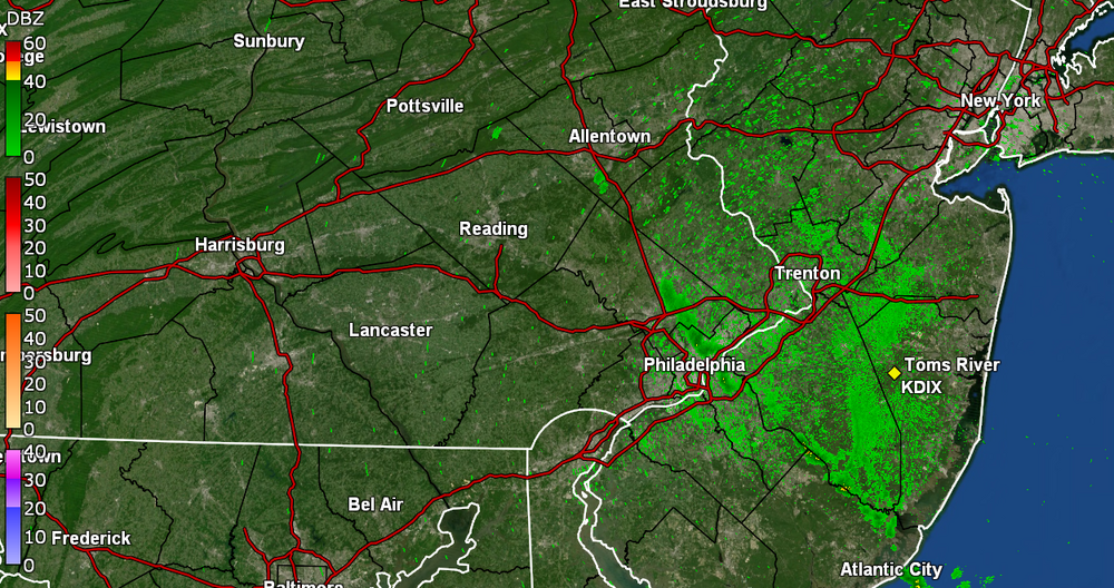
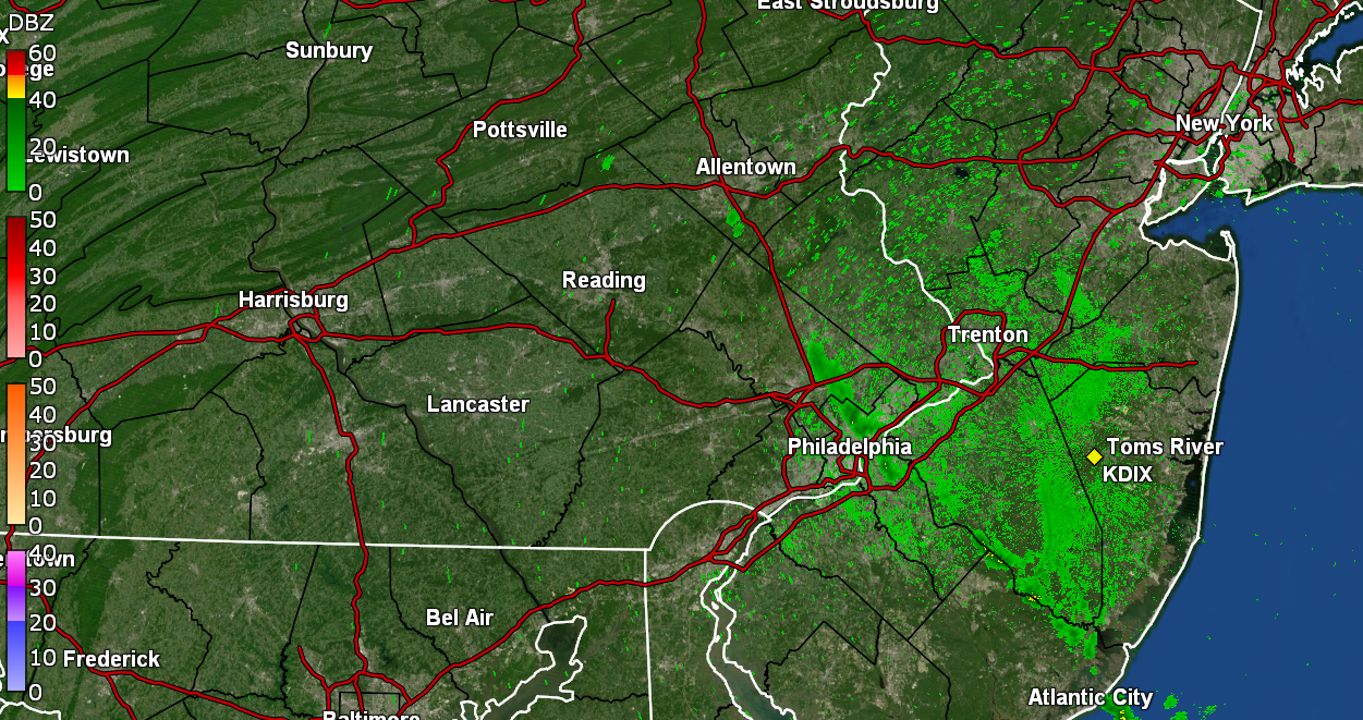
From Mt. Holly regarding those showers:
NEAR TERM /THROUGH TUESDAY/...
As of 6:20pm...Shortwave energy continues to dive south across the forecast area sparking some pulsy isolated to scattered rain showers extending from the Lehigh Valley to Ocean County.
CAPE values currently near 2500 j/kg with weak shear will allow these pulse-type showers to track south-southeastward over the next hour or two before waning around or just after sunset.
-
3 hours ago, Birds~69 said:
69F/DP 51F...predicted low 53F.
Very excited about the 90s next week...
Like being excited about a root canal, lol.
-
1
-
2
-
-
Picked up 0.20" of rain overnight/early morning, August total is 3.92". Not bad, but it's been kinda dry lately, and looks like nothing for the next week. Hopefully our hot spell next week doesn't stick around too long. GFS has parts of the Midwest in the 100's till almost mid-September. Yikes.
-
7 hours ago, TC1 said:
I know it was supposed to be cooler back on Friday, but it didn't really feel like it. This morning was humid as hell thanks to the rain while it was around 70ºF, and this afternoon it still felt like it was in the higher end of the mid-80s (it was actually about 82ºF). Tonight though, it feels cooler and drier (58ºF and a dewpoint of 49ºF). So I guess we'll have a (potentially) nice day today before the heat comes back for Sunday and Monday.
Hello and welcome, new forum member! Today is awesome - here is a snippet from this morning's Mt. Holly forecast discussion. I concur with the last sentence:

-
1
-
-
Picked up 0.25" after midnight last night, August total is now 3.11". As Birds has mentioned, the grass is loving this summer!
-
1 hour ago, RedSky said:
More showers approaching to ensure things stay super saturated
Keep your blood supply up for all your skeeter friends!
-
1
-


E PA/NJ/DE Fall 2023 OBS/Discussion Thread
in Philadelphia Region
Posted
I'm going to go out on a limb and call for more snow than we had last year! I normally don't predict weather and when I do I'm usually wrong, so you can blame me if we get shut out, lol. Looks potentially interesting though.