

Ellinwood
-
Posts
6,182 -
Joined
-
Last visited
Content Type
Profiles
Blogs
Forums
American Weather
Media Demo
Store
Gallery
Posts posted by Ellinwood
-
-
Started as a rain/sleet mix in Germantown, but we're over to all snow as of 5-10 minutes ago. Still light rates.
-
 5
5
-
-
I should just remove I-95 eastward off of my map since it never snows there

My over/under IMBY is 1.5" because that's what I got with the surprise snow in December and if this can't beat that then I'll be sad.
-
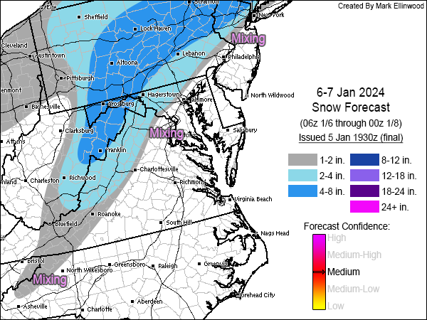
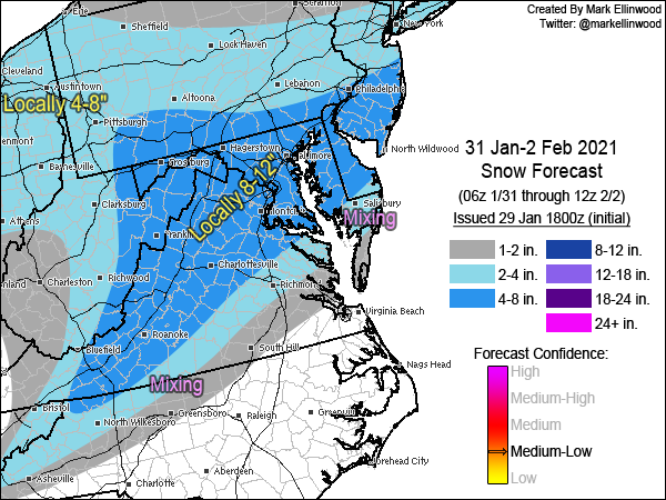
Final forecast. On the southeast side of the snow, I pulled each contour ever so slightly northwest (which I'm still pessimistic on and almost adjusted it further NW than I did). Biggest changes were on the western side of the Appalachians where I added more snow to eastern OH and western PA.
-
13
-
 4
4
-
-
2 minutes ago, AtlanticWx said:
this is just a thought but shouldn't the snow stick almost immediately because of how cold the ground is from the two days of pretty cold temperatures along with those 20 degree DPs up until onset? why use snow depth
Surface temperatures are marginal for a good chunk of the area (just above freezing) and much of the event occurs during daylight hours and questionable snow rates. Getting good rates will be key in the more marginal areas. There's also a relatively stout isothermal layer in the lower levels that will likely hurt accumulation in lighter rates. A lot of the accumulation for the 1-3" crew will depend on how heavy the rates are and how long the heavier rates last.
-
10
-
-
Why are people posting 10:1 maps for this storm it's a complete waste of time and energy to even open it on your browser.
-
1
-
-
20 minutes ago, usedtobe said:
Personally, in these really marginal temp event, I use the snow depth product. It's more conservative with amounts which is a good think. If it's really cold other snow maps are probably preferable. The GFS snowdepth product from the 18Z run. s
Snow depth maps are precisely my main influences with my forecast for this system, though with some touch-ups because some web sites will under-do snow depth if the rates can overcome the marginal surface temps.
-
4
-
-
Been awhile...
I could see some "boom" areas in the far NW burbs of the I-95 corridor if there's heavy rates late Saturday afternoon into Saturday evening, otherwise I'm more pessimistic than optimistic. Lines up fairly well with the NWS at least from Philly southward.
-
25
-
 1
1
-
-
gm
chasing this area today
-
9
-
-
Flip from rain to sleet to snow only took about 15 minutes in Germantown.
-
2
-
-
Wanted to go full weenie along I-95 with what some of the hi-res are spitting out, but due to the timing and uncertainty with the rates I kept things a bit closer to climo.
-
16
-
6
-
1
-
 1
1
-
-
A quick update before a full day of watching the kiddo.
-
12
-
1
-
-
GRAY'D
-
13
-
5
-
 2
2
-
-
Hola.
-
17
-
10
-
2
-
-
Rain/snow mix in southwestern Germantown (mostly snow)... was rain/sleet an hour ago. 35F
-
2
-
-
No changes to my forecast. Playing the usual rule of thumb that the deform band ends up more NW than progged.
-
10
-
-
I like these storms... show up suddenly and no need to track little wiggles for 5 days.
-
8
-
1
-
-
gm
-
23
-
3
-
1
-
7
-
-
Pre-dawn start and cold low-levels will help, but that warm nose is gonna be a bitch.
-
17
-
2
-
-
I'm pessimistic southeast of I-95. Rain or rain/snow mix early and temps struggling to reach freezing there. Hopefully rates can overcome it.
-
16
-
2
-
-
Nothing too crazy. I think the NWS has a pretty good grasp of things right now. I'm relying mostly on the Sunday front-end thump along+east of I-95.
-
7
-
2
-
2
-
-
Just now, Eskimo Joe said:
I'm too fast for ya!
-
3
-
3
-
-
Snow map. Very complicated setup with lots of caveats, but we seem to be converging on a moderate to major snow event across the Mid-Atlantic. IMO major decider will be coastal low development and resulting QPF for Monday.
-
23
-
4
-
-
Final... I hate how much sleet is progged to get northwest of I-95, but IMBY in Germantown I would think 3-5" of snow/sleet with downside 2" upside 6-7" is a good forecast.
-
6
-
4
-
-
21 hours ago, Ellinwood said:
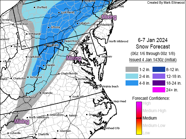
Updated my snow map... cut down on the total on the eastern gradient (mainly DC up I-95 and through southern and central NJ). Increased totals along the Appalachians.
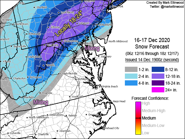
No changes... gradient area near I-95 is boom or bust at this point. Leaning slightly toward bust near I-95, but this isn't worth micro-editing.
-
6
-
5
-
January 6-7 Storm Discussion: we’re due?
in Mid Atlantic
Posted
Finally got some decent DBZ overhead in Germantown, aaaand... it's all sleet.