hudsonvalley21
-
Posts
3,866 -
Joined
-
Last visited
Content Type
Profiles
Blogs
Forums
American Weather
Media Demo
Store
Gallery
Everything posted by hudsonvalley21
-
I think the flooding potential might be more impactful vs.the snowfall. Especially if we get a good amount of QPF from both events. Happy New Years to all.
-
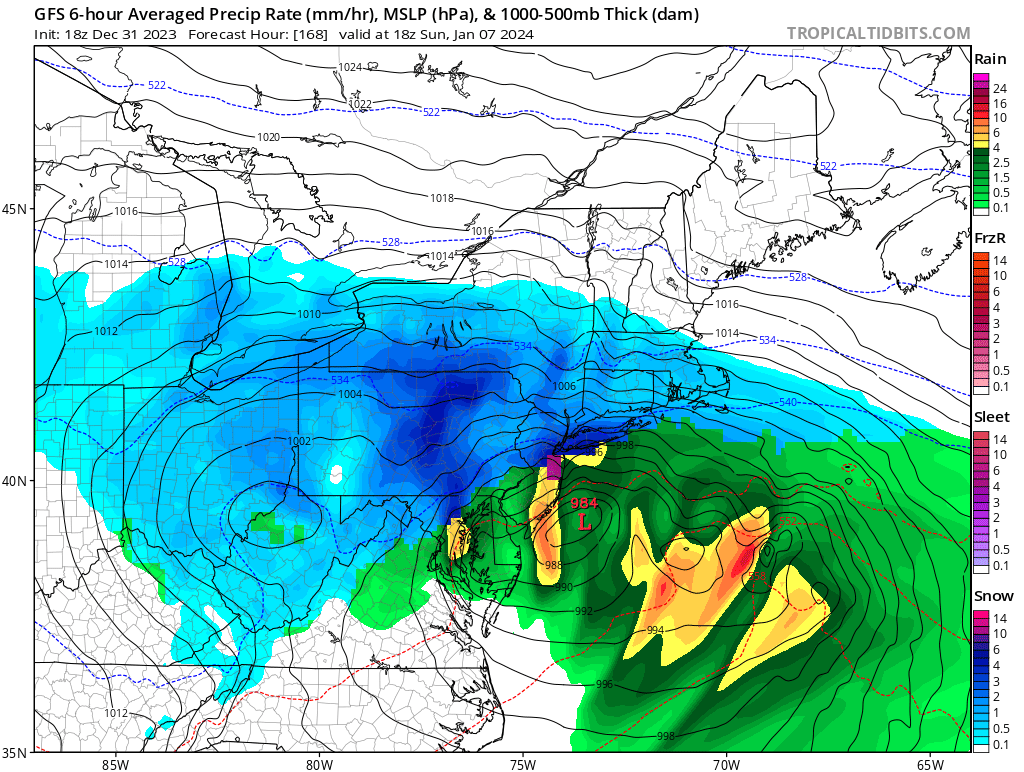
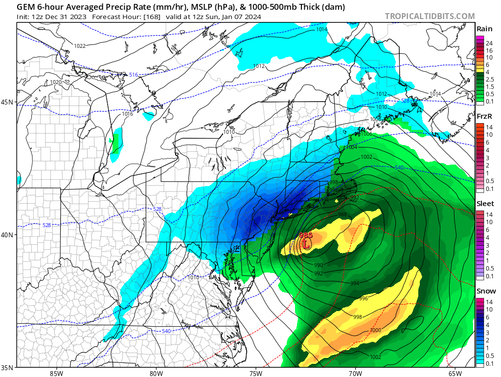
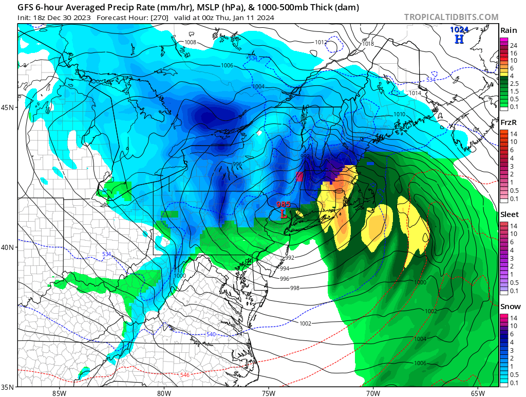
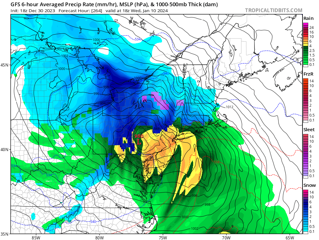
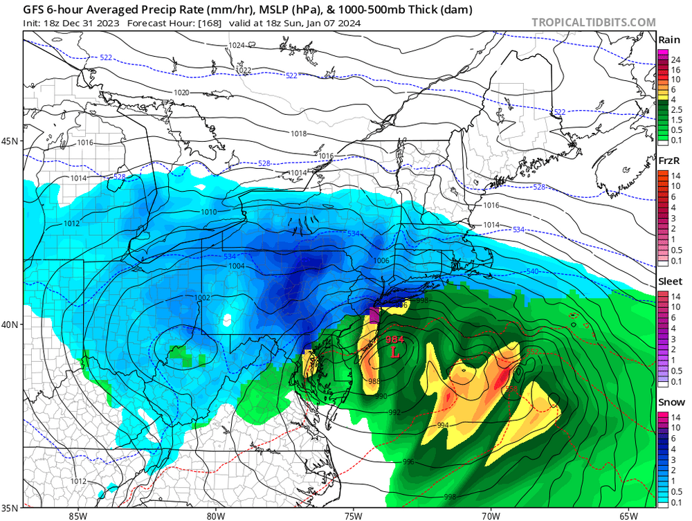
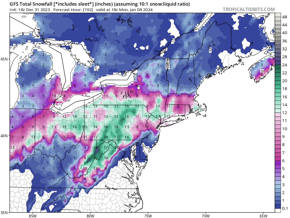
Two Mdt to high impact events NYC subforum; wknd Jan 6-7 Incl OBS, and mid week Jan 9-10 (incl OBS). Total water equiv by 00z/11 general 2", possibly 6" includes snow-ice mainly interior. RVR flood potential increases Jan 10 and beyond. Damaging wind.
hudsonvalley21 replied to wdrag's topic in New York City Metro
And as Walt Drag just mentioned, there is another system on its heels to contend with.- 3,610 replies
-
- 1
-

-
- snow
- heavy rain
- (and 5 more)
-
Two Mdt to high impact events NYC subforum; wknd Jan 6-7 Incl OBS, and mid week Jan 9-10 (incl OBS). Total water equiv by 00z/11 general 2", possibly 6" includes snow-ice mainly interior. RVR flood potential increases Jan 10 and beyond. Damaging wind.
hudsonvalley21 replied to wdrag's topic in New York City Metro
Talking about a different 50. 50 miles of a shift in any direction would make a huge difference in what this run shows. I hate being in the bullseye this far out. That 50 50 low is key. -
Agree with you. The aftermath from these events could be equally as bad as the duration of the events. Sand, salt, sump pumps, and chainsaws may be needed. Especially if we get some snowpaste and winds. Being prepared is key. The 18z GFS is showing a 24 hour event for the Sunday show.
-
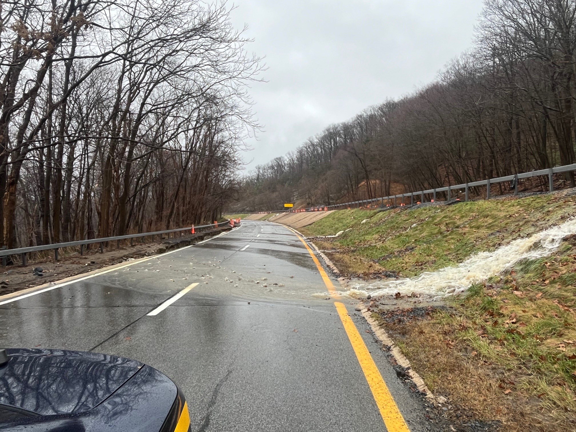
Not a good situation at all. With the runoff still going on and the next events on the horizon possibly being wintery, the roads will be hazardous in spots for some time.
-
Two Mdt to high impact events NYC subforum; wknd Jan 6-7 Incl OBS, and mid week Jan 9-10 (incl OBS). Total water equiv by 00z/11 general 2", possibly 6" includes snow-ice mainly interior. RVR flood potential increases Jan 10 and beyond. Damaging wind.
hudsonvalley21 replied to wdrag's topic in New York City Metro
Thanks Walt, and as you mentioned earlier, the QPF amounts are also critical with the flooding potential.- 3,610 replies
-
- 1
-
-
- snow
- heavy rain
- (and 5 more)
-
I believe the phase would be better if it happens east of the Mississippi River.
-
Well the models are all showing activity. Nice to see that agreement this far out. Clown maps are just weather porn for now. Hopefully there isn’t too much of an impact on flooding issues.
-
When the systems hit the west coast, there will be better sampling. Wait and see for a couple of days.
-
Nice too see if we were only a couple of days out.

-
Fire up one thread, maybe Walt Drag will start another.
-
-
And as we know, this will flip flop like a fish out of water run to run.
-
Subject to change of course

-

-
Maybe a front end thump before a changeover on the 10th.
-
DCA _ NYC _ BOS __ ORD _ ATL _ IAH __ DEN _ PHX _ SEA 1.5 1.2 1.4 0.4 0.6 1.1 1.3 2.0 -0.8
-
2.10” in the Davis so far for the event.
-
Thanks for the heads up Walt, it won’t take much to raise the water levels. We’ll see what the next few runs show. Merry Christmas to you and yours.
-
Rclab, sounds like you have found the Christmas sprit. Have a blessed Christmas! Merry Christmas to all !
-
No snow on the ground there either
-
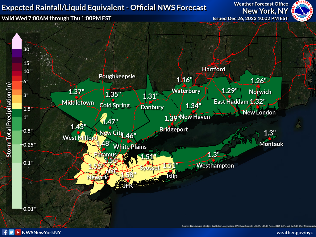
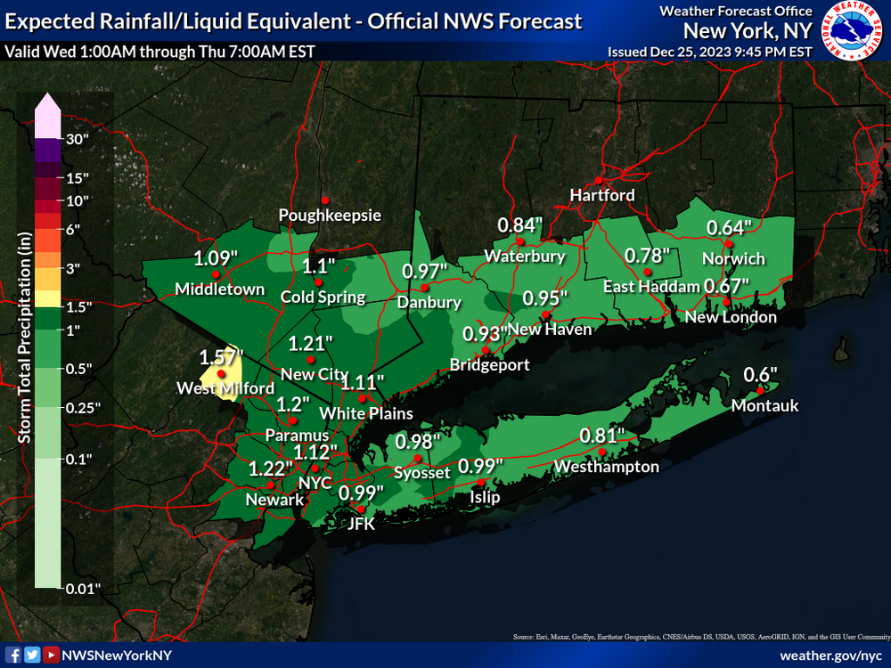
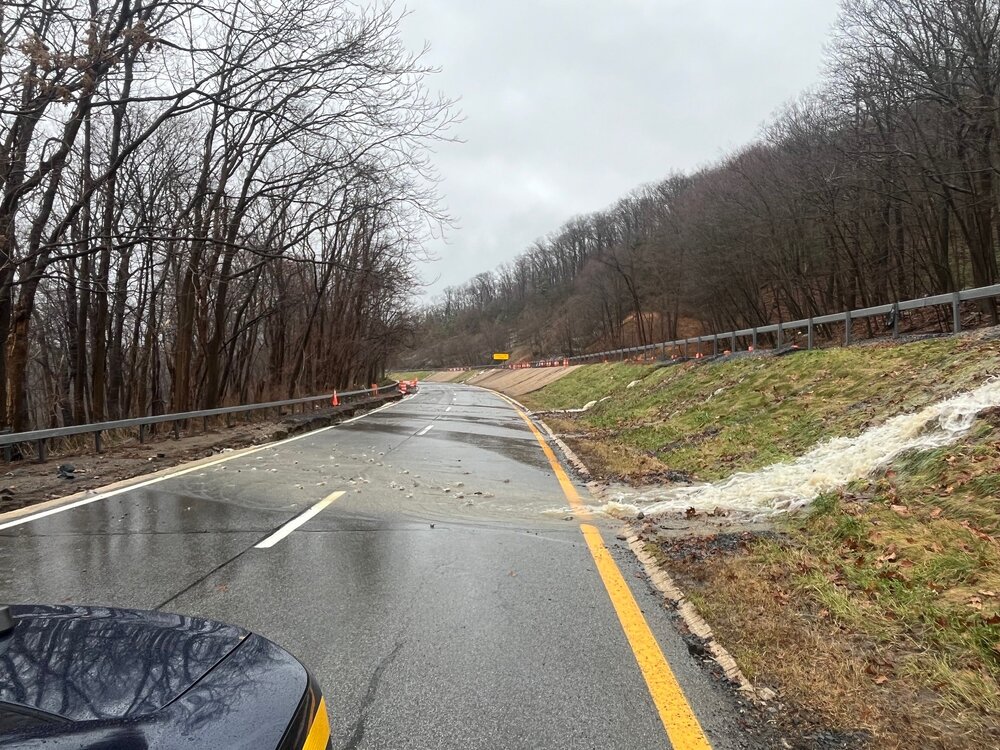
The rain immediately ran off yesterday even after 0.25”. The ground is saturated plus the vegetation that has shut down made an impact on the water levels in the creeks and streams. I heard that there was more road damage on route 6 by the Long Mountain traffic circle from runoff this morning. From NYS police Facebook COMMUTER ALERT ORANGE COUNTY: The Palisades Interstate Parkway is closed between exits 14 and 18 northbound and southbound. Traffic traveling north will be diverted to exit 9W to Interstate 87 northbound, except for local traffic. Route 6 and 293 are closed. Traffic will not be able to enter the Palisades south. Commuters traveling north from New York City are advised to stay on Interstate 87
-
I guess we can call it the new abnormal. The 12z GFS is showing an additional 2” of QPF up till New Years so we could add some icing on the cake. Maybe some of it will be in the frozen type. Always subject to change of course.
-
Moderate-High Impact Storm Noon Sun Dec 17, 2023 - 4PM Mon Dec 18. Flooding rain I95 corridor northwestward, coastal tidal flooding, brief periods of damaging 50 MPH+ wind gusts LI/CT Monday, ends as a little wet snow interior elevations Tue morning.
hudsonvalley21 replied to wdrag's topic in New York City Metro
Very impressive system, 3.84 since midnight along with 0.60” Sunday up to midnight gives me 4.44” for the event total. Upton’s QPF map was spot on for MBY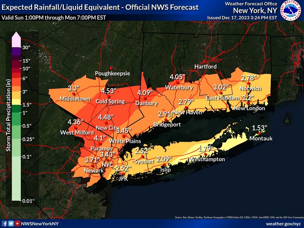
- 489 replies
-
- 3
-
-
- flooding rains
- coastal flooding
- (and 4 more)