
The_Doctor
-
Posts
564 -
Joined
-
Last visited
Content Type
Profiles
Blogs
Forums
American Weather
Media Demo
Store
Gallery
Posts posted by The_Doctor
-
-
18z GFS casually delivers the greatest snowstorm in SE Nebraska history at day 8-9. Including 2 ft in 6 hours on the clown Kuchera maps (hr 222), with 3.5+ ft totals.
-
 2
2
-
 1
1
-
 2
2
-
-
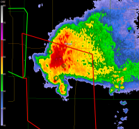
Don't see that color on Radarscope too often...
-
Lol at that backward extension of the watch to accommodate the DBQ storm
-
1
-
-
29 minutes ago, WestMichigan said:
Hope you are as inaccurate as your last call of 0.1 - 0.3". Nice factor of 10 in there you missed with 1.5" at ORD. Maybe downtown was less I don't know.
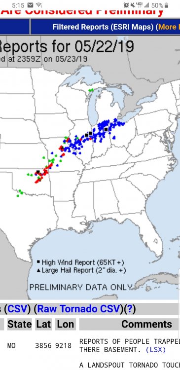
13" rain incoming at ord
-
1
-
3
-
1
-
-
Just to add to the previous watch wind speed discussion, I believe a watch for the May 2009 super derecho had a 105 mph wind speed listed. Although that was a tornado watch IIRC. At an airport so I can't conveniently investigate further
-
5 minutes ago, cyclone77 said:
That new line rolling into the tri-state area of IA/WI/IL means business. Quite a few wind damage reports have been rolling in, and now there's even a tor warning southwest of Dubuque. SPC meso page has been showing steep mid-level lapse rates feeding in from the west, and helping to very quickly rebuild any instability lost from the earlier MCS. Could get interesting down this was in the next hour or so.

They have quite the velo signature on radar right now.
-
3 minutes ago, IWXwx said:
You're probably right about the reason that it's not being cancelled, but I believe that it's up to the local NWS office to cancel the Watch, although they may consult with SPC.
Interesting, I always thought it was the other way around with the SPC consulting with the NWS office but ultimately having the final call. It makes more sense that the NWS office would cancel it
-
SPC has not been cancelling the watch in IN behind the line. They might be thinking the storms in S IL/MO will strengthen as they enter the western part of the watch area. Glancing at the vis satellite shows clearing behind this initial MCS.
-
Just south of Indy the storms were pretty meh, maybe 30-35 mph max gust.
-
14 minutes ago, Jackstraw said:
Thank goodness the 21st has passed. DST just flippin' sucks. Still daylight at 9:30 and twilight after 10? DST wasn't so bad down south but when I moved back here it blew my mind. Especially since IN was a holdout. I don't give a crap about the advantages they spout out. If I wanted to live in the land of the midnight sun I'd be there. Stop f%^&ing with my clock!
I really just feel like we should be on Central time. Daylight savings time and time changes don't bother me, but it's ridiculous when the sun rises at 8:00 AM in the dead of winter and sets after 9:00 PM in summer. I feel that if everything was shifted backwards an hour all would be better. I lived in Illinois for a while as well, and the sunrise/sunset times seemed to make a lot more sense there, with the only issue being how early the sun would set in the winter.
-
A large enhanced did end up getting issued across northern Missouri and southern/western Illinois. These severe wind-producing MCSes are my favorite storms; unfortunately for me this one will turn southeast along the instability gradient long before it gets here. This particular system is actually fairly interesting on radar, with one severe line directly behind the other. The lines are separated by less than 100 miles in spots.
-
Derecho? A few more wind reports occurred east of Cleveland after the 12z cutoff. Not too shabby considering a lot of these areas had <=5% wind probabilities until the 01z outlook.
-
28 minutes ago, KokomoWX said:
Everyone was panicking yesterday when watches and warnings were thrown up locally for some basic thundershowers. Spotters activated but I continued to work on a project in the garage. The weather and those forecasting it need to get better.
Joke right?
-
1
-
-
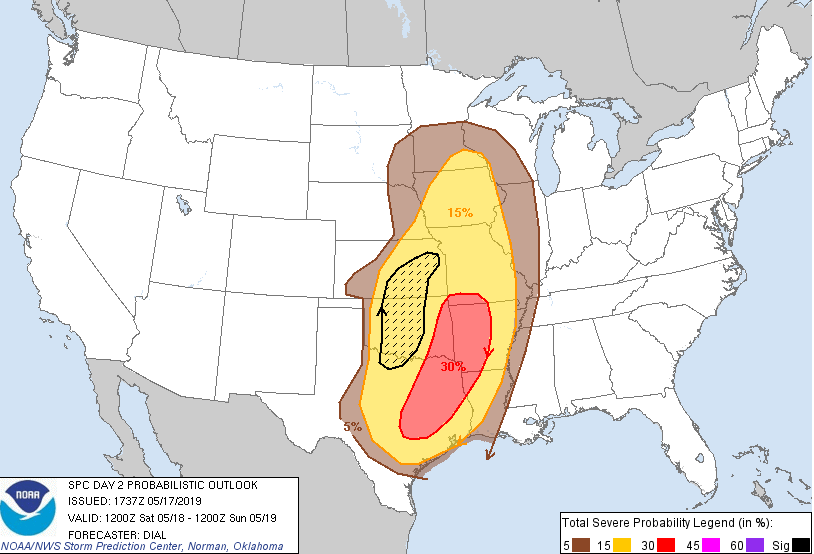
One of the odder looking probabilistic outlooks I've seen, with the sig area totally separate from the higher probs. This is the Day 2 outlook for tomorrow.
-
Just came across this YouTube video of a tornado captured by a drone, taken yesterday. It is easily the coolest video I've watched in some time.
-
1
-
 2
2
-
-
5 minutes ago, Calderon said:
TOR warning for Madison Co., IL, near Edwardsville and moving NE away from the city and the SIUE campus.
It had quite the reflectivity presentation on a previous scan:
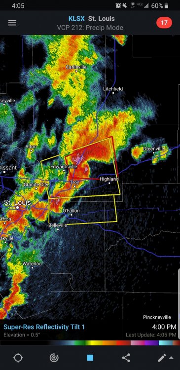
Despite that look it didn't have any significant CC drop to my untrained eye and the velocities weren't too impressive. The warning isn't radar confirmed
-
I can access KIND on Radarscope
-
1 hour ago, Snowless in Carrollton said:
Ive noticed with almost every system the severe weather threat seems to be greater to the south. So im curious as to what month is the best month for severe weather in the southern midwest ? Would it be May?
May through mid-July for Indiana, at least in terms of general severe weather. This loop is pretty good to get an idea of trends throughout the year:
-
hmmm...

-
1
-
1
-
-
50 minutes ago, IWXwx said:
I hope it trends south, right through ORD land. That may give the Cubs a chance to work on their pitching during the game cancellations.
Bullpen has been appalling lol. For real though I hope this goes north. Would be nice to get some storms out of this.
-
2
-
-
Maybe a dumb question, but is there any chance that there were a lot more tornadoes that occurred on that day than we know of? Since it was back in the 1970s? Especially since 30 violent tornadoes occurred out of 148 total, while the 2011 super outbreak had "just" 15 violent tornadoes but 216 total tornadoes. I imagine part of the gap can be explained by the fact that April 27th featured a lot of early morning tornadoes even before the "main event" got going.
-
Some gigantic snowflakes falling right now... I'd hoped we were done with this lol
-
1 hour ago, cyclone77 said:
Just spent an hour or so reading the 6/22/16 event thread. I'm ready for severe weather/chase season.

I'm also hoping that thunderstorm season gets going around here soon. This is my last spring in the Midwest before I move to the West Coast at the end of summer, so hopefully I can experience a couple more thunderstorm events! The West Coast is definitely a downgrade in terms of weather I find interesting (thunderstorms and snowstorms) but the atmospheric river events will hopefully keep me engaged at least. One thing I will not miss is the cold winters. Consecutive 10 degree days has really gotten old for me, especially since I have to walk around in it.
-
2
-
1
-
-
It's just one dude's opinion but some of his analyses are pretty thorough and in depth at least, even if you disagree overall with his assessments. https://extremeplanet.me/2012/07/01/the-non-definitive-list-of-the-strongest-tornadoes-ever-recorded-damage-intensity/
-
1
-


Spring/Summer 2022 Complaint/Banter Hangout
in Lakes/Ohio Valley
Posted
What's the point of having a 60% hatched wind category if you're never going to use it? How do you only issue a Moderate risk at 20z when 20 minutes later you drop a PDS severe watch with double 95s for wind probs? Is the SPC just afraid of marking an event as "High" risk because that's some sacred territory that 8/10/20, 12/15/21, and now today somehow don't belong in (despite easily verifying the probability requirement)? IDK why this bothers me because it doesn't really matter, but jeez just make 60% hatch wind be Moderate already if that's actually the case.