

mrdaddyman
-
Posts
416 -
Joined
-
Last visited
Content Type
Profiles
Blogs
Forums
American Weather
Media Demo
Store
Gallery
Posts posted by mrdaddyman
-
-
4 minutes ago, wake4est said:
Rah as of 5:30
In other words, if you live inside the dotted line, just flip a coin.

-
15 minutes ago, beanskip said:
12z Ukie?
-
 1
1
-
-
11 minutes ago, burrel2 said:
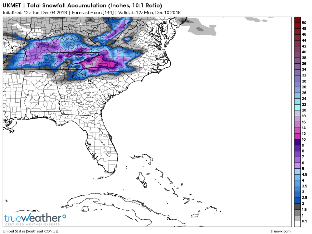
Best I can tell the NMM and ARW have trended colder and more supressed initially. Anybody have some good 12z images?

-
1
-
-
2 minutes ago, Cold Rain said:
I threw this down yesterday. Still looks good to me.
I think you're being generous for our area.
-
1
-
-
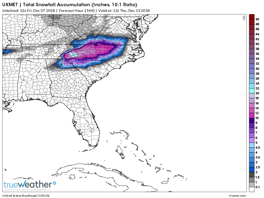
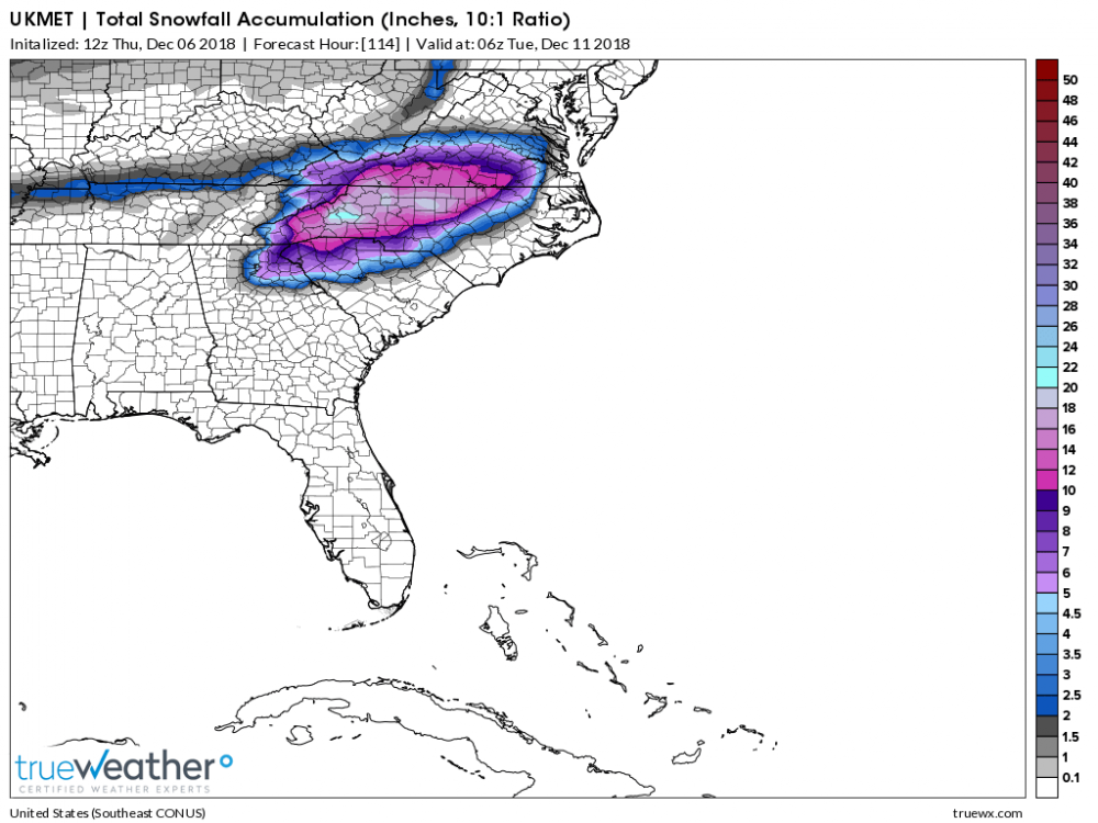
16 minutes ago, wncsnow said:
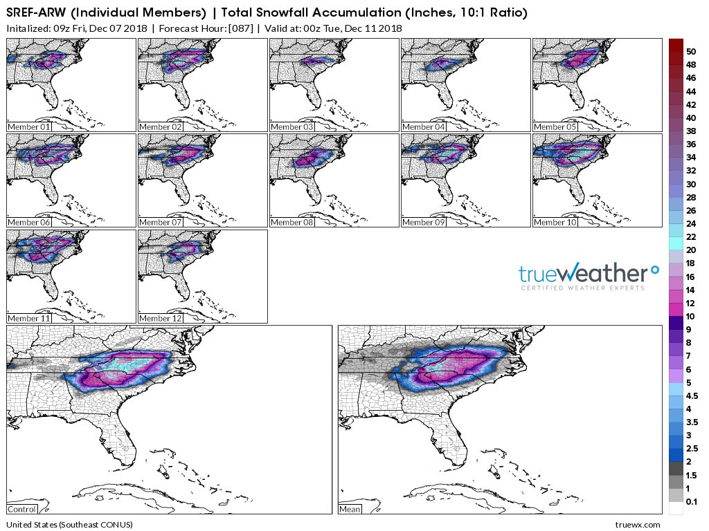
Noticed that no one posted the UKMET.. anyone have some snow maps?
-
1
-
 1
1
-
 1
1
-
 1
1
-
-
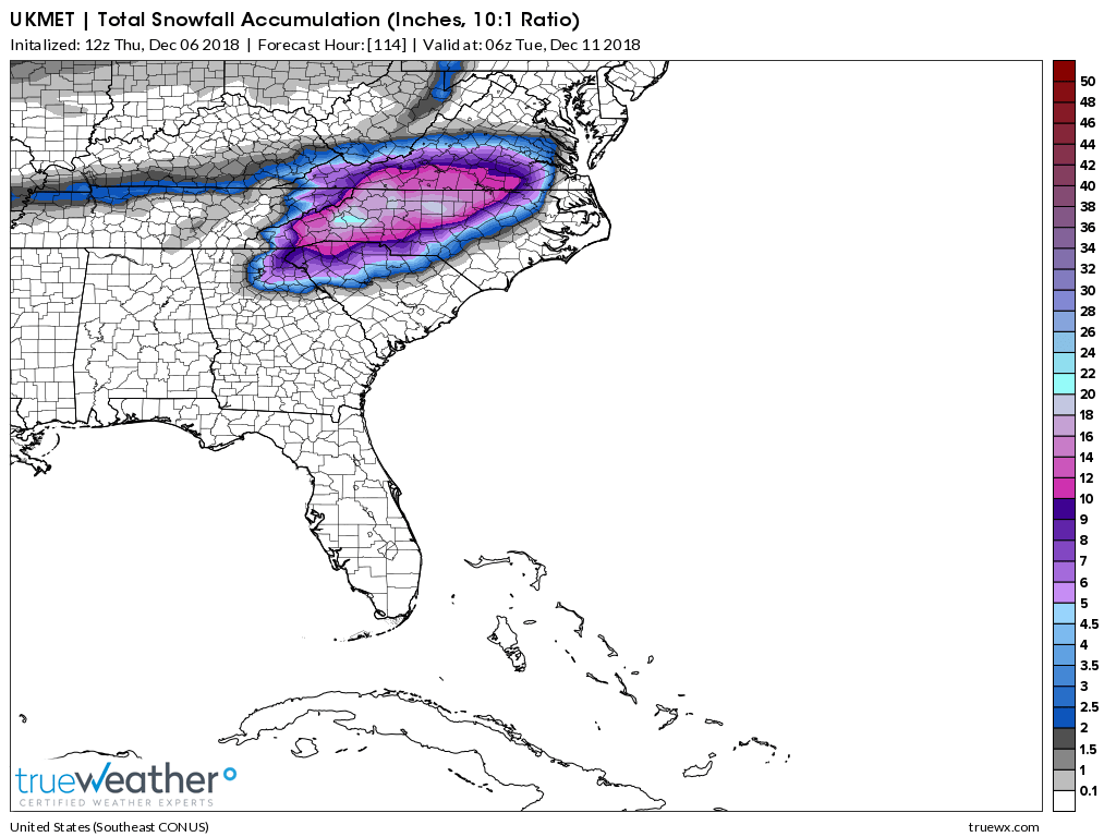
00Z UKMET
-
3
-
-
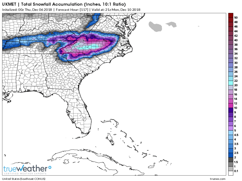
3 minutes ago, Cold Rain said:
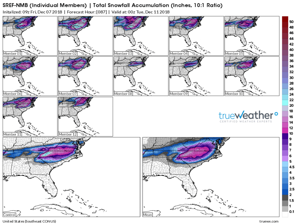
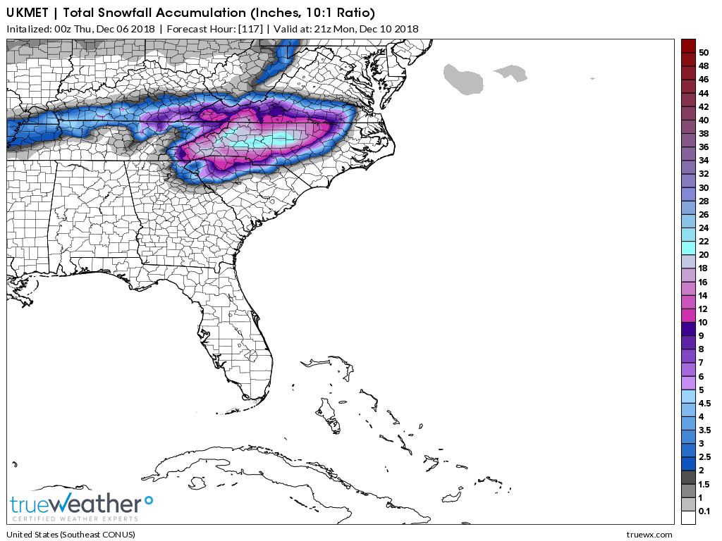
Anyone got the UK snow map?
Believe me, you don't want to see it. The track was further South but it's trip up the coast after that is not a good track for us.
-
58 minutes ago, PackGrad05 said:
Latest model trends don't look good for Wake, especially southern Wake. I'm just not seeing the cold air supply that we need. Borderline = rain.
I agree. I'm not buying the GEFS nor EPS means for Wake/Johnston area one bit. We will be looking at an inch of slop with heavy cold rain after that. I need to keep those maps to compare to on Monday. Seen it dozens of times before. Dearth of the -NAO the last few years makes it all dependent on timing in our area of NC so that the cold air and precip get here in unison. There's nothing to lock the cold air in and that doesn't work out 99% of the time for us. LP needs to track further SE. We are too far East for the CAD to save us.
-
1
-
-
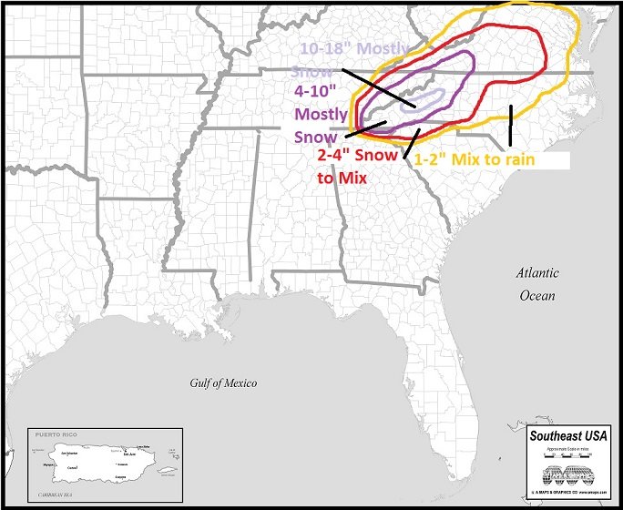
1 hour ago, CaryWx said:
Huh...what---Who woke me? Thought it was Spring.
How's this looking for the Triangle
Unless you sleepwalked about 100 miles NW while hibernating it's going to be a cold rain.
-
55 minutes ago, Hvward said:
12z ICON amps up the low right off the NC/VA shore similar to the 6z run. Looks like the wave digs a tad father south this run. If we can get that surface low to track along the FL Panhandle and a slightly quicker phase, many on this board would be in business. I don't think that it is out of the question, but what it all boils down to right now is that we are tracking a phasing system that will likely bomb out. I wouldn't expect any model to have this system nailed down at this point in time. Lets see what the 12z GFS and CMC throw out.
Yeah, it's not a good track for RDU and points SE. Starts out good over extreme southern Alabama but then makes a beeline for Wilmington. Needs to track about 75 - 100 miles further SE. Not much cold or dry air to work with either.
Edit: I smell a 35 degree driving cold rain with this one outside of the mountains and Northern NC into VA.
-
1
-
-
1 hour ago, Cold Rain said:
Just about every one of those images sucks.
It does for us for sure. Take comfort in the fact that they will all look totally different in about 2 hours from now.
")
-
2
-
-
1 minute ago, WarmNose said:
I hope so! No but in all seriousness, they have a better shot at frozen than we do with this craptastic zonal flow. Looks like Maine may be the big winner if this verifies
Maine is ALWAYS the big winner, every winter.
-
1
-
-
6 minutes ago, Tacoma said:
Yep wish it would snow as often or easy as it rains. Hope there is another snowstorm or two to chase/follow.
The mountains probably have a decent chance at something else before the winter's over.
-
A lot of talk on here today about the "irrelevant" GFS model.
-
15 minutes ago, SnowNiner said:
I agree, it looks like higher h5 heights want to hang on over the southeast muting the cold for a good while and we don't get into the trough until mid February. Again, even then I think we have to hope for another tilted clipper or boundary layer storm.
Doesn't give us much time. Average temps are climbing by that time.
-
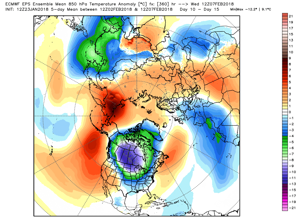
1 hour ago, griteater said:
?? Do you mean the fact that the cold is too far to the northwest?
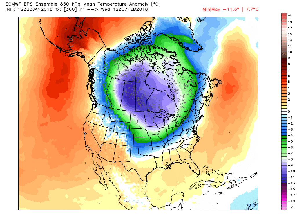
Agree with Mack, those are some impressive cold numbers showing up for a long range ensemble mean, and it's trending colder at the moment at the end of the run. I wouldn't be surprised to see the cold correct more to the south and east in time on the ensembles, especially given the eastward progression of the MJO. Sometimes -EPO cold can get hung up too far to our northwest, but the MJO should help to move the mean western ridge eastward in time through February, with some retrogression back west toward the end of Feb into early March...we'll see.
Also, if those blues were right on top of us, we'd have some playing the suppression card (I don't even have the suppression card in my card deck, ever...bring on the cold, and let's go from there)
The Northern Hemisphere 5 day view shows that look again where the coldest air is in North America...that's a good sign for subsequent cold plunges

Great post Grit. We sure do look to have a favorable pattern coming up in a couple weeks and maybe it will stick around for a while. Hopefully most on this board will be able to score big!
-
1
-
-
1 minute ago, mackerel_sky said:
Looks good to me. All day everyday, twice on Sunday! 360 hour Euro map! Great look, CAD looks primed!
Lobster now coming on the buffet!
If you like ice and power outages.
-
 1
1
-
-
Well this isn't going to get it done.
-
20 minutes ago, griteater said:
Euro has a nice cross polar flow look to it at the end of the run
I know it's a ways out but that looks like some serious suppression with that push of cold air so we might be back to square one where it just shoved everything South. We'll see.
-
16 minutes ago, Cold Rain said:
Winter storm at the end of the run.
Hey CR. If those snow shields keep dropping we might have a chance again soon!

-
9 hours ago, Orangeburgwx said:
seems like it keeps reloading with an extended magazine... wave after wave of cold air shots with maybe two days of warm between them
Those 2 days of warm is when we will get the moisture. Just sayin. . .
-
Just now, CaryWx said:
you know that's a troll joke map, right?
Of course. My post was meant as a joke too. I wouldn't trust a call map forecasting snow 2 days out around here much less a month.
-
1
-
-
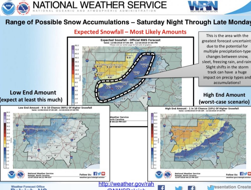
31 minutes ago, RAH_MET said:

Any way you can shift that 8-12 inch line about 50 miles East?!
-
Here we go again. 1/2" of snowfall on the Euro. Went down from 00Z run. More snow to the West this time. Last time it is was snow all around me. Unbelievable.


December 8-10, 2018 Winter Storm
in Southeastern States
Posted
From what I understand, the Hi Res Euro has 9 Km resolution. Doesn't sound like too much of a slouch to me.