

SmokeEater
-
Posts
10,000 -
Joined
-
Last visited
Content Type
Profiles
Blogs
Forums
American Weather
Media Demo
Store
Gallery
Posts posted by SmokeEater
-
-
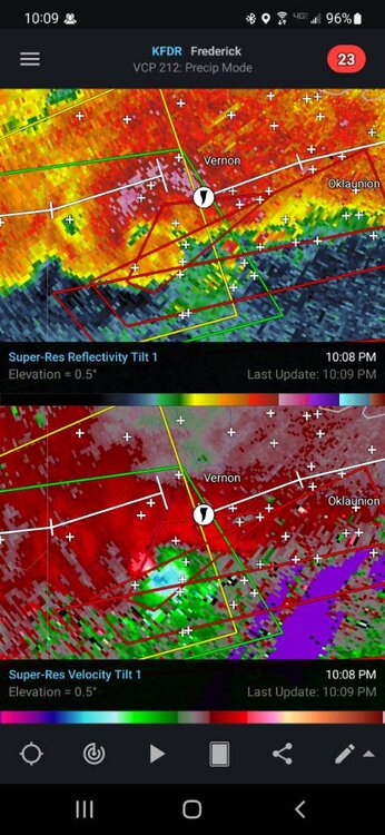
That was 100% down in the middle of the woods, obvious TDS with it for multiple scans at very low altitude too. May have been on Joint Base property, prolly will never be found though.TOR over in Jersey. KYW EAS'd and they cut over to NBC10.
Sent from my SM-S901U using Tapatalk
-
 2
2
-
 1
1
-
-
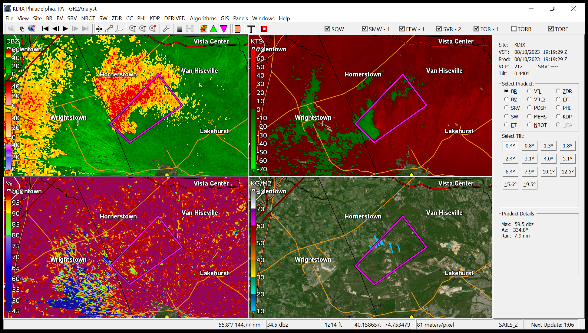
TOG on the Burlington/Ocean County line. Debris ball and TDS multiple scans.
Sent from my SM-S901U using Tapatalk -
It's 100% down, in the middle of the woods too, prolly lofting trees.TOR in NJ...looks decent too. Add another to their list this year?
Sent from my SM-S901U using Tapatalk
-
1
-
1
-
-
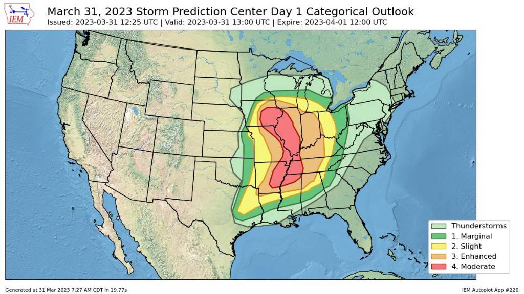
Over the next 1-2 hours, additional storms are expected to form from the Delmarva across far eastern PA and into NJ, as lift increases. Some storms may become supercells, and the tornado risk will also increase through early evening coincident with strengthening low-level shear and cooling aloft. Any increase in dewpoints will also increase the probability of a tornado.
Sent from my SM-S901U using Tapatalk-
2
-
-
They have issued special outlooks before for upgrades or corrections.I'm watching this from afar in NH. I can not remember the last "high" risk. 2 questions. The next convective outlook would come out in 6 hours, right? My second questions is do they ever change convective outlooks with any special outlooks? I know the discussions come out more often.
Sent from my SM-S901U using Tapatalk
-
Probably strongest wording I've ever seen that isn't a high risk.This is the strongest wording I’ve seen in an SPC outlook in a long time. They’re always mindful of their wording and it’s very notable that they not only use the word “violent” to describe the tornado threat; but that strong/violent tornadoes are “probable.”
.
Sent from my SM-S901U using Tapatalk
-
1
-
-
.

Sent from my SM-S901U using Tapatalk -
Controlled burn season, at least in NJ. Most of SJ is hazed out from a couple of them today.Been hazy for a while, but today might be the biggest aggressor so far. What’s with the eternal inversion lately?
Sent from my SM-S901U using Tapatalk
-
 1
1
-
-
Cason, TX was just hit, debris sig over town.
Sent from my SM-S901U using Tapatalk -
Tornado Emergency for Idabel, OK.
Sent from my SM-S901U using Tapatalk -
Big wedge with the centermost tornado.
Sent from my SM-S901U using Tapatalk -
Warning for Chicago itself now. Wrapping up.
Sent from my SM-S901U using Tapatalk -
PDS watch out, 90/80 tor probs.
Sent from my SM-S901U using Tapatalk -
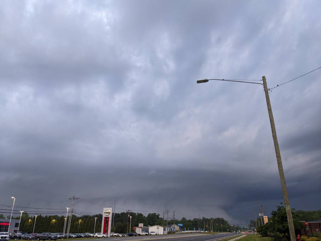
Numerous collapses in that area, scanner going nuts. Also a pic of the supercell, insane structure.Took kids and pets to the basement but didn’t experience much here thankfully. I’m very worried about the Wentworth area.
Sent from my SM-S901U using Tapatalk
-
2
-
 1
1
-
1
-
-
Structure collapses reported in the area now.Worried about Rockingham County…
EDIT: PDS warning now, this is looking really bad
Sent from my SM-S901U using Tapatalk
-
1
-
-
Multiple reports the tour van was rolled with injuries.
Sent from my SM-S901U using Tapatalk -
Lockett took a direct hit, major damage being reported.
Sent from my SM-S901U using Tapatalk -
Large stovepipe tornado continues per chaser.
Sent from my SM-S901U using Tapatalk -
Several power flashes just east of Lockett.
Sent from my SM-S901U using Tapatalk -
.
Sent from my SM-S901U using Tapatalk -
TLX is down, bad time for it to happen. Tech is heading that way.
Sent from my SM-S901U using Tapatalk -
Extremely audible roar at his location, he's bailing south. Can't see it.
Sent from my SM-S901U using Tapatalk -
Very, very large tornado on that, personally know a chaser on it. Just lost visual.Absolutely vicious rotation in the cell just south of Lockett TX, hope it's not a populated area.
Sent from my SM-S901U using Tapatalk
-
1
-
-
Large tornado just north of Seminole, this is nuts.
Sent from my SM-S901U using Tapatalk

E PA/NJ/DE Summer 2023 OBS Thread
in Philadelphia Region
Posted
Snippet from the latest SPC outlook for our area, most of the subforum is now in 5% tornado risk.
The parameter space should be favorable for severe well after dark, with 40-50 kt effective-shear magnitudes, locally enlarged hodographs with 200-300 J/kg effective SRH, and around 1000-2000 J/kg MLCAPE. Convective coverage is uncertain, but all hazards will be possible.
Sent from my SM-S901U using Tapatalk