

Harry Perry
-
Posts
976 -
Joined
-
Last visited
Content Type
Profiles
Blogs
Forums
American Weather
Media Demo
Store
Gallery
Posts posted by Harry Perry
-
-
46 minutes ago, IWXwx said:
Sorry to hear about your hail damage, but it sounds like you did get lucky with a near miss tornado.
As a retired Emergency Manager, I can only speak about local protocol for sounding sirens (and Indiana statewide for the most part), but sounding sirens once for three minutes for an area under a tornado warning is the standard. That is probably true for your area.
I know there is a lot of confusion about sirens. Some people think that when the siren quits sounding, the threat is over. Also, I've heard of locations that sound the sirens for a second time when the warning is cancelled or expired, which also creates confusion.
Sirens are meant to warn people who are outside, with the understanding most people outdoors will hear the siren and take action. It is not meant to be sounded for the entire time the warning is in effect, nor is it meant for people who are indoors. It would be cost prohibitive to place enough sirens in a particular area to assure that everyone indoors could also hear the sirens. That is the job of NOAA All-Hazard radios, the local media, the FEMA app, etc.
If you have questions or concerns, fire away.
Thanks for clearing that up. You would think that I would’ve known that for as long as I’ve been a firefighter, but you learn something new every day. I’m sure that’s the standard here as well, however I have in fact heard the siren cycle for well over 20 minutes in the past. Twice comes to mind in recent memory, 2011 derecho and then again in 2016 during a warning in Marshall.
Seems more reasonable to sound the siren for the duration, especially for the people in that were down-wind in the warning 15-20 minutes away that heard the siren then when it shut off they figured the storm threat had ended. I’m speaking for the general public on that, because that is what they think. I mean, if the government can pay for “gender reassignment surgery”, I’d think we could afford to sound the siren for a PDS for the duration of the event. Just my .02
-
 2
2
-
-
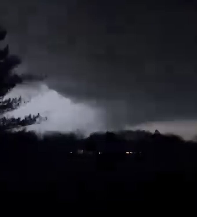
Had too much going on here to post. Had not one, not two, not three.. but FOUR bouts of hail. Each subsequent cell that passed had larger hail, starting at pea size and ending with golf ball/baseball sized hail. The tornado warned cell had a low base visible with lightning off to my southwest. Woke my wife and daughter and told them it was time to go to the basement the same time the sirens went off. They went to the basement and of course I went back outside to make sure it behaved. All local sirens sounded for 2-3 minutes then shut off for the rest of the storm - have some questions for my Emergency Managers on that issue.
As the storm approached, could clearly see the base rotating but extremely hard to see much more than that. Was completely still and quiet with frequent lightning and constant rumbling. Could begin hearing what sounded like a freight train. Kept an eye on velocity scans and CC scans. Sound got louder and louder until the trees began swaying - then another eerie sound of banging started - almost sounded like someone slamming their door repeatedly in the distance, and that’s when the first golfball sized stone smacked the road out front, then the next nailing my two day old new truck sitting in my driveway… wind really picked up and went un-directional and the hail came down in buckets covering the road and yard. Got more hail than snow so far this month.
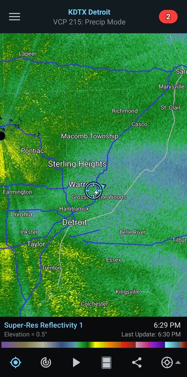
Quick look at radar showed the couplet miss my house by an half of a mile to the north which would agree with the velocity scans.Then, hail finally subsided after approximately 10 minutes but lots of CG’s began just to my southwest. Checked the radar to see the cell behind the tornado warned cell getting its shit together showing massive hail signatures of course, heading directly my way. Went in and checked on the fam, came back up and that’s when the HEAVY marble size hail started with intermittent monsters (golfball to baseball). Obliterated both trucks, again and clearly destroyed both this time around.
Just as the cell would pass and the hail and rain would subside, it would backbuild causing random golfball sized hail to keep falling every few seconds. Was at this time my fire radio stated there was a confirmed tornado on the ground near F Drive North and 26 mile road and near Rice Creek with damage to structures and multiple trees down. Checked velocity and CC to see a tight couplet with a clear debris signature on the previous scan over the aforementioned area.
Long night. Expensive night. Then my daughter woke up at 4:30 (after going to bed at 2) with the stomach flu. Second time this month. I’m beat. Hate it here.
-
3
-
 5
5
-
-
9 minutes ago, Chicago Storm said:
They tend to do that at times, and there's no real rhyme or reason as to why.
Typically this time of year the lakes keep warm frontal boundaries from surging northward past the MI/IN/OH borders, but this year the water temps are well above average and no ice - albeit still cold enough to create a stable boundary layer, just not as profound. They’re probably thinking that the warm frontal surge along with cooler waters will slow the forward propagation of the aforementioned surge while keeping the threat suppressed further south… but for interior regions of southern Michigan, especially away from the lake, I would beg to differ.
Pretty conditional still, but may be in for a surprise.
-
50 minutes ago, HillsdaleMIWeather said:
lol the SPC basically ignored Michigan in the text
Noticed that too.
GRR update did mention their thinking hasn’t changed and that with the realized surface heating and continued heating through the afternoon, the cap will erode as the wave approaches and will set the stage ripe for severe weather of all types across south central MI.
-
1
-
-
Was looking like a bust 12 hours ago, but this mornings runs and full sunshine here are telling otherwise.
-
1
-
-
15 hours ago, Chicago Storm said:
detroit peeps, you alive and alright?
Don’t want to talk about it.
-
 3
3
-
-
There’s something about 30°/40°’s and rain for days in January that just pisses me off.
Looking ahead, February looks like more hot mess. I’d say bring on spring but we all know that spring this year will probably end up being significantly colder than average with more rain and 40s probably all the way through May.. just out of spite to piss us all off.
I need a drink.
-
1
-
2
-
-
Yeah, this isn’t a BIG system but I feel like it’s creeping up to be something from run to run.
The problem up here is with the sub-arctic snow-pack, ground temps in the teens, combined with a warm nose aloft AND all of this happening in the overnight hours - I could see some impacts for a lot of the area.
-
1
-
-
6 minutes ago, HillsdaleMIWeather said:
The low doing unexpected things in Northern Illinois allowed a lot more dry air to get in I think sadly
Yeah, kinda had a feeling this was going to be that kind of storm. Tons of convection to the south too. But hey, we finally got some snow. GFS and EURO nailed the overall track for nearly 10 days lead time which is pretty impressive. The specifics though were terrible. I don’t know that there was even one model close to the outcome, maybe last nights 00z HRRR? I’d have to check.
-
11 minutes ago, Toro99 said:
Probably a bit early, but calling this a massive bust for Southwest Michigan. I have about 5 inches measured, starting at about 2 PM, and now we’re dry slotted. We’ve been under a warning since 10 AM. Not a meteorologist, but just looking at the radar presentation throughout this event so far, it looks like a splotchy disorganized mess, and it has never gotten his act together. If you want to see how the storm was forecasted, look north of Toronto on radar currently, that’s how it was supposed to be here all day and through the night. I know it’s a bit cliché, but I have to believe the southern convection stole a lot of moisture and led to the splotchy precipitation throughout the event so far.
Dry air at the onset of the event and now the massive dry slotting didn’t help either. 5” here as well. Local Mets trying to sell the idea that the deformation snow is coming by 1am and will be intense through tomorrow lol, I just don’t see that happening. The main event is over for areas south of I-96.. time to turn our attention to the lake-effect for tomorrow into Sunday. Not expecting much around here, but you should do very well in GR.
-
4” here so far with back end approaching quick from the SW.
-
33 minutes ago, Stebo said:
IT WAS SO FUCKING LOUD
That was just for you brother. Can’t see it any other way.
-
2
-
-
Snow has begun here.
-
1
-
-
Been under moderate/heavy returns for going on 3 hours now with not a single snow flake at the surface and a hellacious east wind.
Feels like an impending bust, especially if the rain/snow line makes it here before we finally get anything at the surface.
-
1
-
-
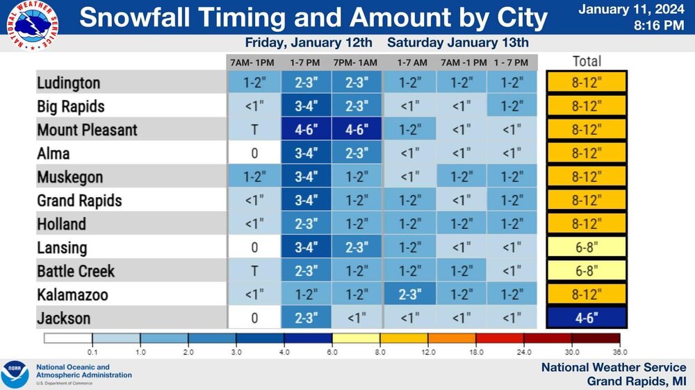
GRR just put out this graphic. Very reasonable and in-check totals it would appear.
Differs entirely from the point and click forecasts and everyone on Facebook is having a meltdown over it. Love to see it.
-
The differences among the models this close to the event is downright ridiculous. Some of the short range guidance is still over-doing the warm tongue aloft, while others don’t have it at all creating massive differences in snowfall.
It would make the most sense considering the strength of the slp to draw in warmer air at the surface (33-35°) while the low passes nearly overhead here and to the east, with that, there will be rapidly dropping temps on the backside of the low drawing in much colder air at the mid levels and the surface as it moves northeast. If this thing suppresses a little quicker, colder air will be realized sooner thus more snow.
At the end of the day it’s really a crapshoot but around here I’d expect the snow to mix with rain for at least a few hours tomorrow late afternoon and to pinpoint any accumulation depends on how much rain actually does occur.
-
7 minutes ago, Harry said:
It has but was as well with last system which as we know ended up a bit se of gfs track.. That's our hope anyways. Shouldn't be worrying about to far NW with a damn Ni o as is... Ugh. Climate change for you..
Gotta love it. Nice having you in here!
-
6 minutes ago, Harry said:
I just know with past experiences that with a nino the trend tended to be se close in vs Nina and the nw trend.
And with this type of system I want the slp at least 100 or more miles to my south and east. Just not east of Toledo/Detroit.. But that's me of course.

You and I both. There’s such a wide range of possibilities with this it’s ridiculous. GFS has been very consistent with this system, but wouldn’t mind a bump southeast.
HRRR and other short range guidance giving us another cold Eurythmics special.
-
1 minute ago, ChiTownSnow said:
Skilling showed an IBM graph model....wtf is that?
In house model? Or is it the GRAF model?
-
Crazy how there’s over a week of consistency followed by a 200+ mile NW trend inside of 48 hours. Twice.
-
6 minutes ago, mimillman said:
You love the SREF

-
That map gives me flashbacks of a few days ago for today.
-
2
-
-
10 minutes ago, CheeselandSkies said:
Not bad consistency on placement and intensity 36 hours apart:


Excellent consistency. This solution screams mixing/dry-slotting issues for pretty much all the areas that got shafted today as well.
Will be sampled tomorrow, should give us a better picture on what’s going to transpire, LOTS of moving pieces with this.
One thing for certain, GRR will issue an advisory regardless of the outcome.
-
1 hour ago, Stebo said:
Nah this storm is going to go west and make sure it clubbers Chicago while it rains again here.
Kinda has that look to it honestly.


March 2024 General Discussion
in Lakes/Ohio Valley
Posted
HRRR dropping further south each run around here. Might be able to cash in on a little action.