-
Posts
4,156 -
Joined
-
Last visited
Content Type
Profiles
Blogs
Forums
American Weather
Media Demo
Store
Gallery
Everything posted by Windspeed
-
Agreed, and that got brought up because Michael still looked absurd in AVN. I do use both versions of colorized IR though. The new Enhanced IR gives detailed color bands (pinks to whites) in the -80° to -90°s range, which is useful for super intense overshooting tops in mesoconvective systems and volcanic plinian columns that punch through the tropopause. Occasionally you will get a TC in the deep tropics that will cool to that range. But it is otherwise kind of overkill for TCs and certainly not as useful as a comparative tool to past TCs. -70°C reds to -80° dark color band is a perfectly fine cap on AVN. Unfortunately I find the -60° to -70°s color bands much too dark on the new Enhanced IRs. It does make TCs in general look stronger if you were accustomed to AVN all these years. But now we have access to both colorized IRs, so whatever, it's all good.
-
Since NCEP stopped automated posting of GOES products (Himawari products are still being posted at current time) to the older SSD server, weathernerds.org began to use that color scheme as an option for measuring cloudtop temperatures. And yes, I agree, AVN is a valuable tool if not a more scathing one for historical comparison. Anyway, my eyes and empirical obs in general are better suited for 40 years of AVN because that is what I am used too.
-
I edited my post to mention the Azores (again), but obviously it would be a weaker purely tropical hurricane or at least a weaker baroclinic-forced hurricane versus what it is now. However, thereafter, most modeling had it phasing into a strong Northern Atlantic low in the medium-to-long range.
-
If that is the case, I hope they plan to head out there this evening. Obviously Lorenzo is not a threat to anything but shipping interests in the short-term (obviously the Azores may come into play), but from a meteorological perspective, Lorenzo is fascinating. It could very well end up surprisingly deep/intense based on recent satellite trends. It would be awesome to sample this hurricane near peak intensity.
-
ADT continues to increase. Lorenzo's entire CDO includes a band of -70°C or lower cloudtops now:
-
Did you quote the wrong post? That blurp by me was from yesterday evening before the new eye took over.
-
Impressive...
-
To be fair, Julia is the most eastern CV hurricane to reach Cat 4 intensity in the Atlantic Basin, however, it pulled this off 10 days earlier, and in comparison to Lorenzo, it was tiny. Julia's far eastern location will likely remain a record for Cat 4 intensity for many years due to how incredibly rare it has been observed in the satellite era. But Lorenzo's period of intensification doesn't appear to be leveling off yet. Lorenzo will likely end up stronger than Julia, though I am not expecting it to reach Cat 5. It will certainly end up being the most intense TC we have observed that far east in the MDR and also during its eventual trek up through the central Atlantic. Julia at peak intensity:
-
Scroll up and read my last discussion. Again, in the least that would aid in short term reintensification but how that plays out as the larger atmospheric features and strong ridge axis evolves is anyone's guess. It would certainly have better chances than being further northeast and under strong NErly flow. There is a pocket there vs the ridge axis in westward track that Karen could take which might allow it to skirt unfavorable conditions. The ridge would need to build overhead and place mid-level flow more easterly to help aid vertical stacking. The rub in all this is future PV placement and axis of SWrly upper level flow, which would not be favorable for a W to WSW moving TC. But where exactly does that feature develop? Karen isn't dead yet but it needs help and some luck on latitudinal/longitudinal track. Otherwise it is destined to degenerate long before posing any potential threat to the Bahamas or points west.
-
The persistent sustained convective bursting within the MCS may be supportive of enough surface pressure drop to relocate the low level vortex further southwest within Karen's overall broader surface trough. A new LLC may be forming around 63W. Will have to see what recon finds but that combined with the stall should still be watched. It only needs to close off a vortex in a location more susceptible to steering influence by the developing ridge axis to get a jump-start on west to wsw motion. This again would aid in placement within a pocket of better atmospheric favorablility, convergence and forward motion. Though the cards are still stacked against Karen, the further SW it is located when westward motion begins, the better chance of reintensification and a system to still be watched. The recent models have been reluctant to support redevelopment, however, potential changes such as these can also change modeling in the short and medium range.
-

2019 Atlantic Hurricane Season
Windspeed replied to AfewUniversesBelowNormal's topic in Tropical Headquarters
-

2019 Atlantic Hurricane Season
Windspeed replied to AfewUniversesBelowNormal's topic in Tropical Headquarters
Lorenzo should become intense enough to get the N. Atlantic Basin above the century mark for ACE. @ 88.8 we are just above climatological mean of 76.4 for this date in the season. This season should finish well above average as we may have a few more MDR systems. Of course there is always the western Caribbean to watch out for in Oct. At this time, the N. Atl. and N. Indian are the only basins above seasonal average for calendar date. The N. Hemisphere as a whole is below average @ date with 332.3 (373.1). -
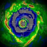
Pinhole eye. Probably won't last long with such well-organized outer banding, which will likely lead to an ERC and a larger eye. Nothing suggestive of a change in track at this point. Still looks like a powerful central Atlantic major. Need to keep an eye on possible interaction with the Azores though. Depending on recurve trajectory could be one of their strongest impacts.
-
Not so fast on Karen being toast. ECMWF initialized too far north and also leads to too much latitude gain in the short term. As such, Karen is subjected to northerly to NErly mid-level shear and strong low theta-E into a weak vort. That will kill most struggling systems. However, if Karen is @ a lower latitude and finds itself SSE of the ridge axis, atmospheric conditions will be more favorable, especially if Karen manages to grow convection/MLC again and align its vort tomorrow. Not throwing in the towel yet until I see where Karen is located tomorrow evening with respect to the building 594 dm axis.
-
That feature being discussed above is a mid-to-upper level low. It's not represented much below the 400 mb level though. This feature could actually help enhance Karen as it retrogrades WSW if Karen would ever get its act together and consolidate a stacked vortex. But alas, Karen is finicky and hasn't shaken off its interaction with PR and NErly mid-level displacement.
-
That's a mean for projected return. It doesn't suggest we are due in another 10-20 years, only that per climatological average, a sub-900 mb landfall occurs within a spread of 102 years. There could be more or less years, or even 300 years between such events. I would need to read the paper in more detail on how they came up with those means. The 265-yr mean seems much too large to me however these are modeled datasets from projections and not historical observations since we do not have measurements prior to the 1800s. There are only a few estimated examples of such strong tempests prior to that due to captain logs or governing records.
-
12z HWRF looks more realistic this run in that it shows several periods of MCS/MLC redevelopment being sheared off on approach to PR versus organization and intensification to strong TS or Cat 1 hurricane shown in previous runs. That is the most likely scenario. Run is not through but it's kind of pointless with so many unknowns on dissipation, stall or turn, etc. Better to watch globals at that point.


