

J.Spin
-
Posts
6,151 -
Joined
-
Last visited
Content Type
Profiles
Blogs
Forums
American Weather
Media Demo
Store
Gallery
Posts posted by J.Spin
-
-
1 hour ago, mcglups said:
what an amazing storm as it comes to be! that 'red' shading is appearing here.
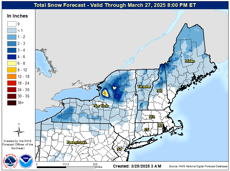
Thanks for passing that along. With touches of that 18-24” shading along the spine of the Northern Greens, that seems to jive fairly well with the BTV NWS high elevation point forecasts I’m seeing. Since that map is out through Wednesday morning, it should certainly be including any back side of accumulations from the system.
-
4 hours ago, Ginx snewx said:

I see that Ginx already passed along the updated BTV NWS Storm Total Snowfall Forecast map, and I’ve added the updated alerts map below. In the BTV NWS forecast discussion they mentioned that most remaining areas with Winter Storm Watches were converted to Winter Storm Warnings, as the map indicates.
Checking out some of the local point forecasts, I see that down here in the valley our snowfall projection is in the 8-16” range through tomorrow night, and the nearby mountain forecasts are topping out around 24”. There’s none of that next tier accumulations shading showing up along the spine, but the current Storm Total Snowfall Forecast map only goes out through 7 PM tomorrow.

-
5 hours ago, Ginx snewx said:
Days of upslope
3 hours ago, bwt3650 said:
You called the last one so keep it coming.The BTV NWS forecast discussion mentions the potential for a few inches of upslope for Monday night on the back end of this upcoming storm. The 3K NAM has it going through about midnight before a bit of a short break, and then potentially some lake moisture visiting the area on Tuesday. After that, the next potential systems in the pipe are a polar front on Wednesday, and then a similar one on Friday night/Saturday. We’ll have to see how this upcoming larger system plays out of course, but 3 to 4 systems affecting the area over the course of roughly the next week seems like a good Northern Greens style regime to potentially keep the snow surfaces refreshed. The BTV NWS forecast discussion also noted that the northern/central areas were removed from the flood watch due to cooler thermal profiles, so that’s good.

-
 1
1
-
-
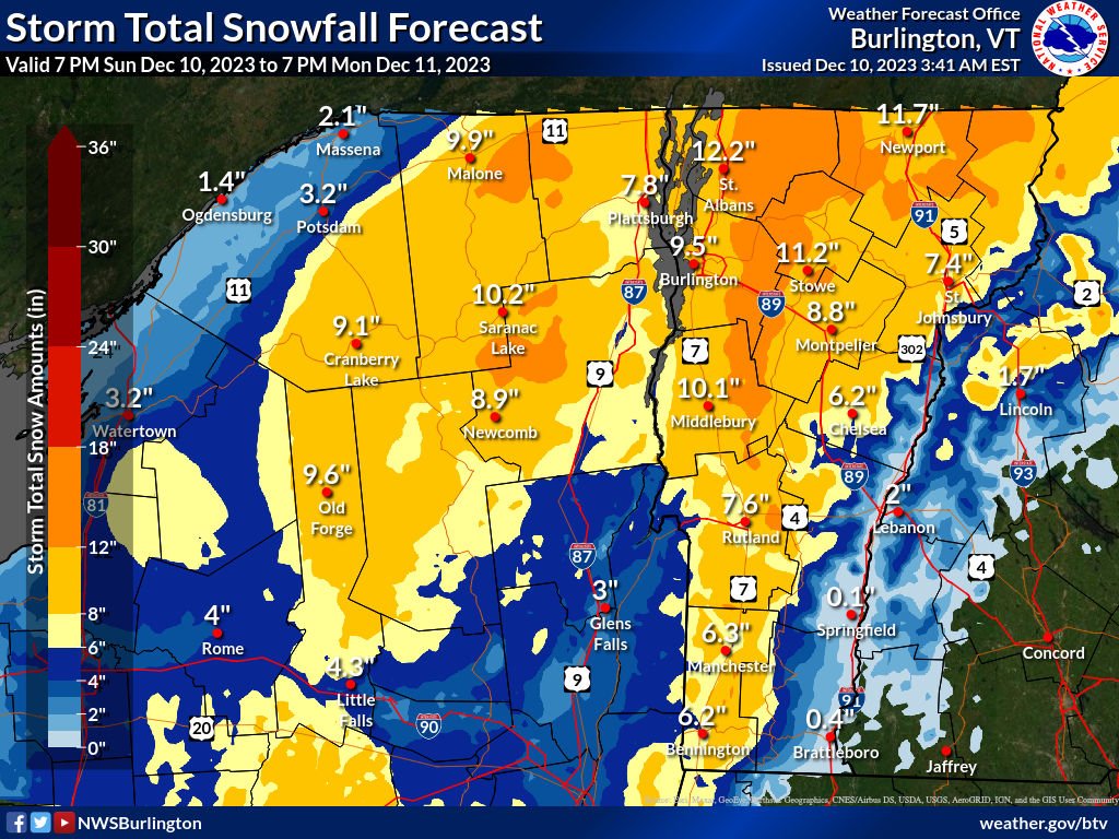
The Winter Storm Watch here has been converted to a Winter Storm Warning, and the BTV NWS forecast discussion suggests totals topping out in the 10-20” range for the Central/Northern Greens. The latest maps are posted below.
National Weather Service Burlington VT
349 PM EST Sat Dec 9 2023
.SHORT TERM /SUNDAY NIGHT THROUGH MONDAY NIGHT/... As of 342 PM EST Saturday...Upgraded winter storm watch to warning acrs most of VT, where confidence is highest for warning criteria snowfall. Very little change has occurred with our storm total snowfall thinking localized 10 to 20 inches central/northern Green Mtns of VT.


-
2
-
-
About an hour ago I received a text alert that we’d been put under a Winter Storm Watch, so clearly the BTV NWS is seeing something at this lead time that has them concerned about the potential snowfall with this upcoming system. Current maps have been added below:


-
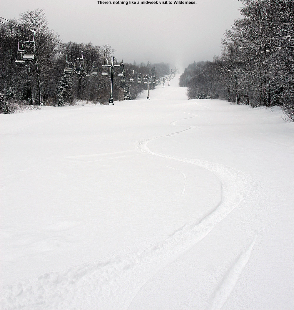
I was busy through most of the afternoon, but still wanted to get out to the mountain today to check out the additional snow that fell on the back side of our most recent system. As the temperatures dropped yesterday, the density of the snowfall fell to 10% H2O by the afternoon, and finally down into the 3-4% H2O range overnight. Bolton Valley was reporting another 5 inches of accumulation as of this morning, and that drier snow atop the substantial amounts of denser snow from the earlier part of the storm would likely set up some excellent turns.
Since I was starting my tour around dusk, I fired up my headlamp because I knew I’d need it on the descent. What amazed me this evening was the number of people who were out touring by headlamp as well. I knew that folks got out for Wilderness tours after dark because I’d sometimes see them on their way up when I’d be finishing a late descent, but I had no idea just how substantial the numbers were. During the course of my relatively short tour this evening I saw at least a couple dozen skiers out there for headlamp touring, and most of them were actually ascending or just starting out at the parking area. Indeed, the Village parking lot was teeming with skiers, more than I’ll typically even see for a morning session. I guess that part of local ski culture is clearly alive and well. And I can’t blame folks for getting after it this evening, it was dead calm with temperatures in the 20s F with new dry powder atop a substantial base. I can remember a couple decades ago when folks would need to set up these elaborate, heavy battery packs to run their powerful halogen lamps to have enough light for skiing at night, and that all seems pretty irrelevant now with modern LED headlamps. My little LED headlamp was more than powerful to enough to provide light for me to ski, even on its lowest setting. I did use the brightest setting on the descent since I figured I might as well, and it was potent.
In terms of the snow, with settling I generally found 2 to 4 inches of the new drier snow in the 2,000’ to 2,500’ elevation range. In some spots it was easier to distinguish the demarcation between this drier snow and the denser snow below as I probed around, but at higher elevations where even the base snow was drier, it became more and more difficult to separate the new snow from the old. In any event, the quality of the skiing took a nice notch upwards with the addition of the new powder. I’m sure the earlier snow dried out a bit as well, but with this new snow on top, turns were much silkier than yesterday, and lower angle terrain was much more in play and enjoyable since you were gliding through fluff instead of sinking into the denser stuff. There’s excellent midwinter skiing to be had out there right now in the Northern Greens, whether you go during the day… or at night.


-
6
-
-
Of the 11 winter storms we’re recorded at our site so far this season, 3 have delivered more than a half inch of liquid equivalent here at our site in the Winooski Valley, and they’ve had a notable upward trend in L.E. The November 21st storm brought 0.72” of L.E., the November 26th storm brought 1.14” of L.E., and this most recent storm that began on December 3rd brought more than 1.40” of L.E., with snowfall continuing through the overnight period. These storms have really helped to build the mountain snowpack, and the snow depth at the Mt. Mansfield Stake is now more than a foot above average.
Bolton Valley was reporting another 14” of snow in 24 hours, and I popped up to the mountain yesterday afternoon to check it out. Elevation has had quite an impact on the snow from this most recent storm, and the snow depth profile coming up out of the Winooski Valley is quite extreme. There’s really no snow aside from leftover piles, all the way up above 1,000’, and then the depth begins to ramp up. Here’s the snow depth profile I found on yesterday’s ski tour:
340’: 0”
500’: 0”
1,000’: 0”
1,200’: T-2”
1,500’: 6-8”
2,000’: 16-20”
2,500’: 20-24”
3,000’: 24-28”
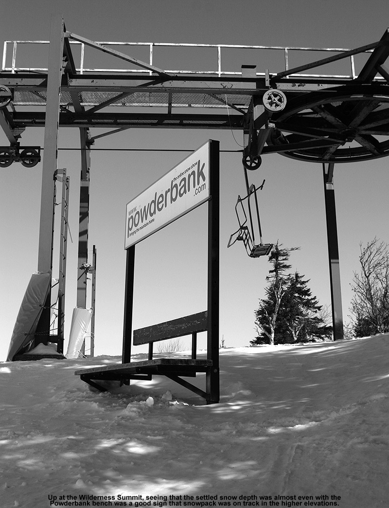
It was more challenging to get depth readings in those upper elevations since the pack is getting pretty deep and there are a lot of different layers with varying consistencies, but that general trend I’ve seen of almost an inch of depth increase per 100’ of elevation gain seems to generally be holding. The depths I was getting at 3,000’ also seem generally in line with the current reading at the Mt. Mansfield Stake of 33” at 3,700’.
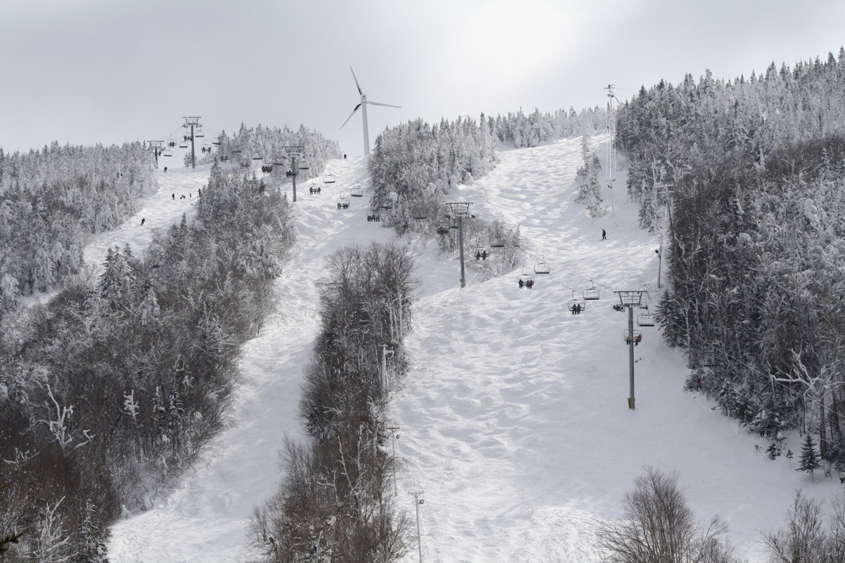
I arrived up in the Village in the early afternoon to a maelstrom of huge flakes coming down in association with the back side of the storm system, so the mountain continued to tack on more to the snow totals. Fat skis were unquestionably the play for today. The accumulations from this storm definitely came in denser than the previous one, and while fats were of course great for stability, they were also really nice for planing on lower angle slopes and getting additional turns out of that snow. Even though you were only sinking maybe 6 to 10 inches into the powder because of the density, it was still slow going if the slope angle got too low. Steep slopes indeed offered the best turns, and the base is so dense and deep that even on those pitches there’s not much to worry about in terms of coverage on the upper mountain.


-
12
-
-
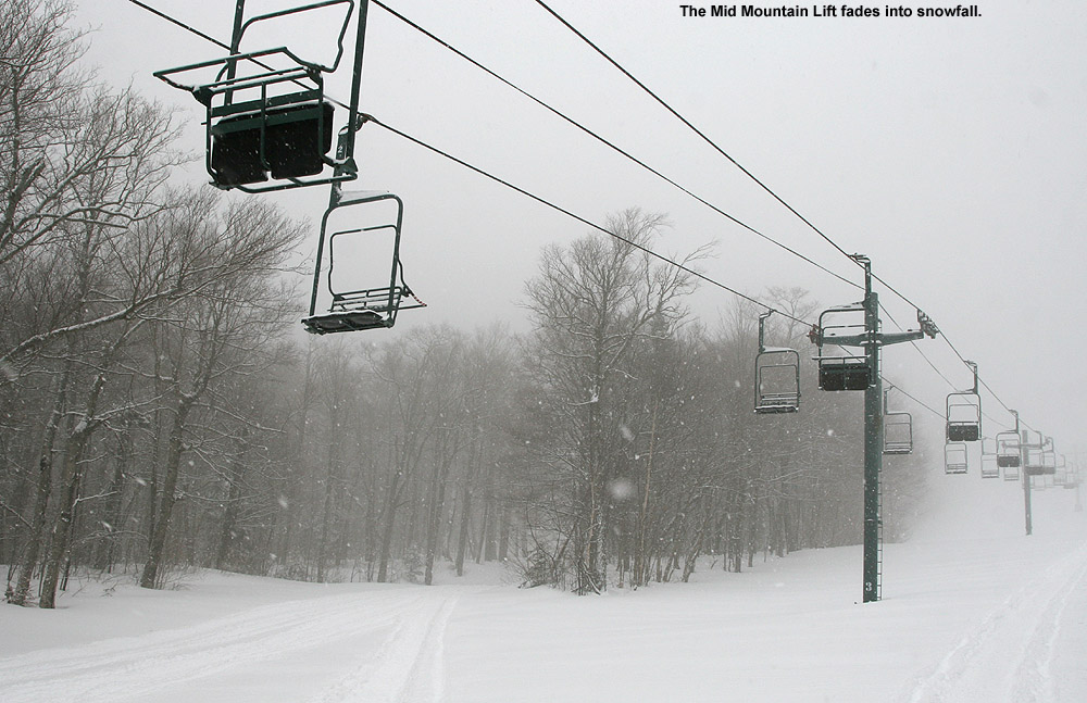
Down here in the valley at 500’ our precipitation has generally been snow, but the temperatures have been marginal, so thus far we’ve had less than an inch of accumulation. It’s been a different story at elevation though. We’d been watching the Bolton Valley Base Area Webcam since this morning, and more often than not it’s shown moderate to heavy snowfall with some big fat flakes. Even from the webcam you could tell it was accumulating, so I waited until the afternoon to let some of new snow build up, then I headed up to the mountain for some runs.
Coverage has mostly melted back at the base of the Bolton Valley Access Road at 340’, and the precipitation there was a mix of rain and wet snow, but cars coming down from the resort had at least a couple inches of fresh snow on them. As I ascended, somewhere in the 1,000’ to 1,500’ range, the precipitation instantly flipped to 100% snow, and you could tell that you’d hit a critical temperature threshold. Up in the Village at 2,000’ it was pounding big flakes. There were visibility issues just like yesterday, but while yesterday was due to thick low clouds and fog, today it was due to the snowfall.
Liker yesterday, I skied again off the Mid Mountain Chair, and you could tell that the base snow had stiffened up where it had been groomed, at least up around 2,500’. From about 2,200’ and below, there was a notably softer base. At those higher elevations where the base was starting to tighten up, the new snow was definitely helping to take the edge off, but with on piste skier traffic, the fresh snow had been pushed around a lot, and you had to move off the groomed terrain to really take the best advantage of the new snow. In areas that hadn’t been groomed, there was no demarcation between the new snow and more recent layers below it, and my off piste adventures generally yielded turns in 12-14” of powder. The powder did get a bit denser as you dropped in elevation, but it was still quite manageable. I was on mid-fats and never even felt the need to switch to alpine turns; the snow was dry and consistent enough that Telemark turns were still comfortable all the way.
The freezing level was slowly dropping in elevation while I was out on the mountain, and by my last run it was only right down at base elevations where the groomed base still had that initial softness I’d encountered. Driving down the access road at closing time was a bit hairy with the pounding snow and fresh accumulations. The road accumulations finally started to abate around 1,500’, and road surfaces switched to just wet below that. The snowfall rate was easily an inch an hour at times, and even thought it occasionally slowed down for periods earlier in the afternoon, it looks like it averaged around that inch per hour mark because the resort was reporting 4 inches of new snow as of 4:00 P.M. closing. If the snowfall keeps up for a while this evening like it did this afternoon, they’ll have another great shot of snow to cover up the slopes by the morning.


-
3
-
-
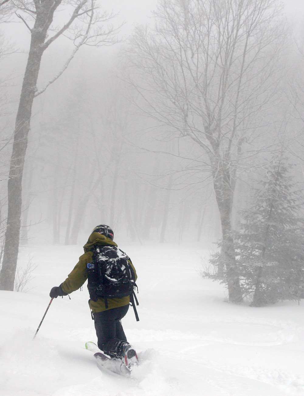
With temperatures in the 30s F today, I was unsure if snow surfaces up at the mountain were going to soften. Our younger son was up at Bolton Valley with some friends though, and when we texted him for an update, he said that indeed the snow had softened up. With that news, my wife and I headed up for a few runs this afternoon. Visibility was near zero on the mountain with low clouds and fog, but it did give the mountain that low light solstice/holiday feel.
Indeed the snow surfaces were great. We’d waxed our skis pretty thoroughly just in case, but we didn’t encounter any areas of sticky snow, it was just buttery smooth spring-style snow that you could really sink an edge into. I’m not sure if the snow was stiffer up high, but we were just lapping the Mid Mountain Chair, and everything on the lower mountain was great. The Wilderness Lift was also open today, so the natural snow terrain that they’ve opened is still in decent shape. Those surfaces that have softened today will of course tighten up when temperatures drop back below freezing, but hopefully the storm coming in to the area tomorrow will do a decent job of covering up the current base. There certainly seems to be the potential for a decent resurfacing of the slopes with an inch or so of liquid equivalent in the forecast.


-
5
-
-
Just as we were headed up to the mountain this afternoon, I received a text alert that we’d been put under a Winter Weather Advisory. Related BTV NWS maps are below. The Event Total Snowfall map has us somewhere in the 6-8” or 8-12” range of accumulations through Tuesday, but we’ll have to see how things play out for the lower elevations during the warmer part of the storm.


-
1
-
-
Last night we picked up another 4 to 5 inches of snow here in the valley from the weak cold front swinging through the region, and not surprisingly, the mountains picked up twice that amount. Bolton Valley was reporting 10 inches of new snow atop the 15+ inches they’d received from the storm at the beginning of the week, and this new snow came in around 5% H2O according my morning liquid analyses. The new drier snow atop the base was a recipe for some great skiing.
My older son was off from work this afternoon, so we popped up to the mountain for a ski tour on Wilderness. The Winooski Valley down by the base of the Bolton Valley Access Road did better with this event, and whereas the coverage was somewhat patchy after the last storm, it was generally continuous with a few inches present this morning. I checked snowpack depths during the tour as usual, and it’s getting tougher to get measurements as the snowpack gets deeper, but with settling through the afternoon, depth increases seemed to be as follows relative to what I found yesterday:
2,000’: 10-12” --> 15-16”
2,500’: 15-16” --> 18-20”
3,000’: 18-20” --> 20-24”
So essentially, the snowpack depths I found today were about 500 feet lower in elevation than equivalent depths I found yesterday.
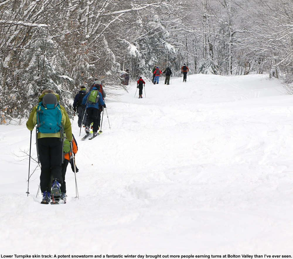
The Wilderness Uphill Route had seen plenty of skier traffic, and there was a dual skin track all the way to the Wilderness Summit that made conversation easy while we ascended. I was hoping to bring my son over toward Fanny Hill again in line with the tour I’d done yesterday, but ski patrol had fenced off Upper Crossover. They really want touring to be confined to Wilderness, and I guess that’s not too surprising with the amount of operations they have going on Vista. With the amount of activity we saw going on all around the resort, it’s obvious that they’re going full tilt in preparation for re-opening on Friday. I’m not sure how much of the mountain they’re going to open, but with the amount of natural snow out there, they’re going to have a lot of options.
In terms of the skiing, it was great. Conditions were already excellent yesterday, and now Mother Nature threw another 10 inches on top of that, so it’s about what you’d expect – lots of bottomless powder. We hit the Wilderness Summit just as sunset was approaching, so the views to the west were stupendous on such a fine afternoon. With the snow remaining deep, you wanted to shoot for intermediate pitches and above for decent turns. Based on my experience from yesterday, we did have full fat skis today, so that helped a lot with floatation and the ability to turn on those lower-angle slopes a bit more.


-
7
-
-
On 11/27/2023 at 9:39 AM, powderfreak said:
I’m hearing 10-12” Mansfield. Only ski on the top 4” of it though. Given QPF of 1.00-1.20” if you get into the 10:1 ratio zone it’s probably a foot.
Did not expect 6-7” down at 750ft.
On 11/27/2023 at 1:24 PM, bwt3650 said:
Just what we wanted to fill things in..jay now says 15 up top. Certainly possible as there’s close to a foot at 1850’When I checked the Bolton Valley snow report today in anticipation of heading up for a ski tour, I saw that they had updated their Monday morning total to 15” up top as well, so they must have reassessed what fell:
Tuesday: We are still reeling from the season's first big snowstorm that smothered the northern Green Mountains in a heavy blanket of prime base building snow Sunday night to Monday morning. In addition to the 12-15" we woke up to Monday morning, it appears we're in for another 1-3" today here in the upper elevations and - perhaps even more importantly - the return of cold temperatures on the ol' "wet bulb" to fire up snowmaking efforts again. As we get closer to Friday we'll keep you posted on trails and lifts for this weekend, but perhaps needless to say, we will definitely be expanding terrain this weekend, including Snowflake Lift, a small buildout in the HIde Away Terrain Park and several trails making their season debut. Stay tuned on that front.
No lift service today, but we've gone ahead and opened the Wilderness Designated Uphill Route so you can get some fresh pow laps in if your schedule allows.Based on PF’s comment about skiing on just the top 4”, and the density of the snow down here at our house, I brought mid-fats for today’s tour. I figured I’d be riding Sierra Cement, but that wasn’t at all what I experienced. I’ll mention more about the snow density after covering the storm accumulations and snowpack depths.
There’s a very impressive elevation gradient with respect to the snow accumulations from this storm. Down at the base of the Bolton Valley Access Road at 340’, there isn’t even complete coverage on all aspects – I’d call the snowpack there T – 2”. I didn’t monitor the snowpack too closely on my ascent to the Village, but coverage was certainly continuous by 1,000’. Up in the Village around 2,000’ or so, I found 10-12” of snow, and here are some measurements at elevations during my tour:
2,000’: 10-12”
2,500’: 15-16”
3,000’: 18-20”
As the numbers reveal, there’s a huge snow depth gradient above 2,000’ – you’re basically looking at the depth going up about an inch every 100’ of vertical. Now those numbers are for total snowpack depth because I’m not sure if I’d be able to distinguish exactly what portion came from this most recent storm, but much of it was from this storm (as Bolton’s summit storm total of 15” would suggest).
The Wilderness Uphill Route has a beautifully packed skin track in place at this point, so travel on the snow is easy. And getting back to that discussion of snow density, it’s not Sierra Cement. In the higher elevations, the density going several inches down into the snowpack is sub-10% H2O powder – I’d put it somewhere in the 6 to 8% H2O range if I had to guess. You sink well down into it, I’d say a good foot, and it’s nicely right-side-up. As I mentioned, I brought mid-fats, but fat skis are actually the tool you want (or a snowboard, etc.).
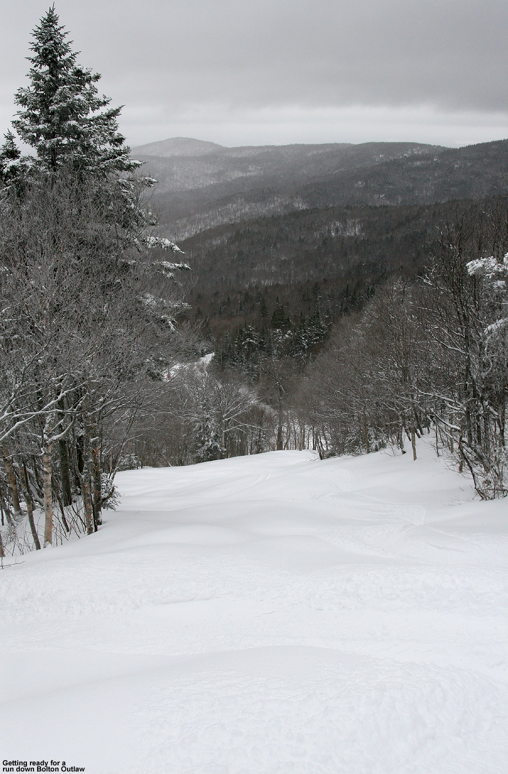
It was quickly obvious on my ascent that some decent pitch would be required for turns, so I toured all the way to the top of Wilderness. I checked out Bolton Outlaw, and it had seen enough traffic to track it up pretty thoroughly, so I continued on to Upper Fanny Hill and put the third set of tracks down there. I continued on to Fanny Hill proper and got probably the fourth set of tracks there. The powder skiing is fantastic as long as you’ve got at least intermediate pitch. Shallower than that and the powder is just too deep to keep decent momentum (and that’s another reason to bring fat skis because you can make use of that extra floatation).
In terms of snow quality, it’s as I described at elevation, and of course the overall depth decreases as you descend, but the quality stays high right down to 2,000’. Only just as you approach 2,000’ do you encounter any sort of snow quality issues, and there’s a slight crème brûlée crust in there a couple of inches below the surface where there must have been a bit of warming. At that elevation it’s still quite subtle and you can essentially ignore it.
As Bolton’s snow report indicates, the resort is considering expanding terrain, and moving to some of the natural snow terrain is pretty obvious at this point. We’ll have to see which terrain can hold up to lift-served traffic, but I can’t believe there’s not more talk about this storm and what it could do for the start of the season. This storm was a total liquid equivalent bomb, and not only that, the snow is good to go. This storm was an absolute season-starter. Sometimes storms like this come in so dense or warm, that the tenor will be “This is going to be a great base as soon as we get some good snow on top of it”. Well, there’s no need to wait, the snow is already good to go, and it’s currently getting covered more with the snow from today. It’s not every day you get such a base-building storm that immediately offers up fantastic midwinter skiing. We didn’t even have to wait until December for this one – it somehow snuck in during November, which is another great bonus.


-
6
-
-
4 hours ago, powderfreak said:
It is absolutely dumping silver dollar flakes of fluff. What a wintry day. 2” new at the mountain this afternoon.
58 minutes ago, powderfreak said:Giggity. What an end to November. It’s snowing nicely in town with an inch down.

The mountain is getting absolutely throttled. Near 2”/hr stuff.
 1 hour ago, powderfreak said:
1” past hour at Mtn.
Getting blitzed.

The snow around here today was persistent, but generally light. This evening though, it’s been ramping up to another level. Even on the basic BTV NWS radar you can see much of the spine lit up from with that WNW flow coming in. The snowfall is 1-2”/hr. at times with visibility maybe a couple hundred feet.

-
2
-
-
5 hours ago, powderfreak said:
Gonna call it 10” here I think as I can’t prove a foot or more… though with this heavy wet snow you could say any number up to 16” and it would probably past the “feel” test.
I just cannot estimate a snowfall number, it goes against my weather morals… much to the chagrin of people who think it’s 12-14” on Mansfield lol.
4 hours ago, mreaves said:A colleague who lives in Wolcott says they got 12"-14". I asked his elevation and he said 500' higher than Morrisville. I will say he's a counselor and social worker not a meteorologist, though he is a longtime Smuggs skier.
4 hours ago, powderfreak said:Yeah I’m not saying that’s impossible but in my experience heavy wet snows are over estimated if no one measured them.
BTV didn’t get any inhabited reports over 12”… even up at 1800ft spotters were in the 9-11” range it looked like. That fits with bwt’s “almost a foot” at 1850ft too.
Personally I think it was probably 8-12” at most higher elevations with 1-1.25” of water.
Plenty of folks today at Stowe were saying the 8-9” of dense at base was a foot. I think just the dense snow type makes it seem like so much more. Step into it and it’s like wow, this is a foot of real deal snow!
Here’s the north to south listing of the snowfall totals that the Vermont ski areas along the spine are reporting. The totals reported in the north and north-central areas are definitely higher than in the south, and the distribution is actually reminiscent of the north to south gradient we see with a lot of more typical storms that have upslope added in.
Jay Peak: 15”
Smuggler’s Notch: 14”
Stowe: 10”
Bolton Valley: 12”
Mad River Glen: 14”
Sugarbush: 13”
Pico: 7”
Killington: 7”
Okemo: 8”
Magic Mountain: 2”
Stratton: 5”
Mount Snow: 3”
-
About a half hour ago I received a text alert that we’d been put under a Winter Weather Advisory – this seemed to come on pretty quickly, just as the snow was starting up here, so I assume the BTV NWS has seen something in the latest modeling that had them go with the advisory. We are getting a bit of slushy accumulation when the snowfall intensity is high enough, but with the marginal temperatures, it seems like heavier snowfall is what it would take to get any sort of substantial accumulation down here in the valley.


-
2
-
-
1 hour ago, Kevin W said:
Guys, I think everything should be all set.
Let me know if there are any issues, and I'll check back here later.
(I don't get emails or notifications from here and I cannot find the reason why)Thanks Kevin; I just tested it by entering the storm totals from this season thus far, and it seems to be working smoothly as usual. The effort that goes into this resource is greatly appreciated.
-
The mountain snowpack that had been building up over the first half of the month melted back somewhat in the middle elevations at the end of last week, but this latest winter storm seemed to have the potential to replenish it. As of this morning, we’d picked up roughly 4 inches of new snow composed of 0.6 inches of liquid at the house, so the local mountains should have added enough new snow to set the table for more low-angle touring in the powder. Bolton Valley was reporting 3 to 4 inches of new snow overnight, and 5 inches in the past 48 hours. Assuming a similar density of snow to what fell at our house, plus whatever snow was in place before, it definitely felt like it was worth a visit.
In the Winooski Valley at the base of the Bolton Valley Access Road, we found 1 to 2 inches of new snow from this most recent storm, and up in the Village, total depths were 4 to 5 inches. Temperatures this morning were around the freezing mark, with a mix of wintry precipitation types as we set out on our tour. We found that snow depths increased a bit with elevation, hitting 5 to 6 inches around 2,500’ and 6 to 7 inches where we topped out around 2,700’.
The powder skiing was decent, with snow that was relatively dense but not sloppy or soggy on the upper half of our tour. The density did increase a bit more as we descended back toward the base around 2,000’, but the snow still hadn’t progressed to that spring-style sticky snow. I had freshly waxed up my skis in the morning, and that did appear to help give me an slightly easier time than my son who hadn’t.
While today’s powder was decent, the snow I found while out ski touring last week was definitely superior. I think that last week there was a touch more base, the snow overall was a bit deeper, and most importantly, the snow was notably drier. All those factors came together to set that skiing above the quality of what we found out there today. This dense snow that we just received does have the water content to set up a more substantial base though, and it’s really going to be great with some additional rounds of snow on top. The models do suggest that there are some events in the pipeline over the next week, so we’ll see what the mountains get from those.


-
5
-
-
I see that the BTV NWS made a bit of a bump around here in the numbers on their Event Total Snowfall map, and that change is represented in our corresponding point forecast as well. Based on the forecast discussion, it sounds like it was due to some increases in the projected liquid equivalent from the storm.
National Weather Service Burlington VT
657 AM EST Tue Nov 21 2023
.NEAR TERM /THROUGH WEDNESDAY/...
As of 650 AM EST Tuesday...
…There were also some increases in liquid equivalent amounts which favor slightly higher localized snowfall amounts for the Adirondacks and Green Mountains.
Snow...General amounts haven`t changed much; still expected 2-4 inches for the Adirondacks and southern/southeastern Vermont. However, the increase in QPF has nudged the potential slightly higher for a few very localized spots to see 6 inches; can`t completely rule out these amounts.
Updated maps for this event are below:


-
I received a text alert earlier this afternoon that we’d been put under a Winter Weather Advisory. The associated BTV NWS maps have been added below.


-
12 hours ago, J.Spin said:
 4 hours ago, bwt3650 said:
Nice winter vibe there.
Nice winter vibe indeed – and while we haven’t had any huge storms yet, these typical November rounds of snow have been building up to the point that people are definitely getting out to enjoy it. That second image in my report with the person in it was someone I saw just as I was finishing up my ski tour – they were out for a Nordic ski around the Village, and I bet it was someone who lives right up there. I saw them passing above me while they skied the access road, and I quickly fired off a bunch of shots before they disappeared into the clouds. PF’s winter vibe Stowe pictures from Saturday definitely played a role in getting me out for yesterday’s ski tour. Since I couldn’t quite get a solid visual from the Bolton Valley Webcam to know how the snowpack was looking, I was just about the head down to the basement for another pre-season leg workout… but thinking about how the higher elevations looked in PF’s pics helped tip the balance. If that was what it looked like before this most recent storm, there had to be enough out there at this point for some low-angle turns. And there certainly was.
With the clearer skies today, you can now see that Mansfield is lit up with the white of the recent snows from about 3,000’ on up, so that’s definitely helping with the winter vibe as well.
From what I note in the GFS modeling and BTV NWS forecast discussion, it looks like the next snow chances are coming right up in a couple of days as we head into the pre-holiday weekend, with a cold front coming through Friday into Saturday, and a northern stream shortwave Saturday into Sunday. As the BTV NWS explains, getting more than just a few snow showers from the cold front would require a more GFS-style solution vs. an ECMWF one, but both models do show the shortwave.
.LONG TERM /SATURDAY THROUGH TUESDAY/...
As of 327 AM EST Wednesday...Heading into Saturday, reinforcing northern stream shortwave energy will likely result in scattered terrain-focused snow showers as snow levels fall to below 1500 ft. The cold air advection will also steepen the low-level lapse rates, allowing for breezy 15-20 mph northwest winds. With temperatures in the 30s to low 40s, it will feel more like the teens and 20s. A wild card to consider is the evolution of the upper level pattern with regards to the coastal low that undergoes explosive cyclogenesis as it tracks close to the 70W/40N benchmark and into downeast Maine/New Brunswick on Saturday. The 00z GFS indicates a faster transition into a negatively tilted trough as downstream ridging builds over Newfoundland by Saturday afternoon. In contrast, the 00z ECMWF is more amplified with the H5 trough, resulting in the transition from neutral to negative tilt not occurring until Saturday night. If the GFS solution materializes, then the colder air will catch up with the exiting precipitation shield, resulting in the formation of an anafrontal wave east of the Champlain Valley and rain changing over to accumulating snow. Whereas if the ECMWF is right, then only scattered snow showers are expected. There is still time for model guidance to come into better consensus so be sure to monitor the latest forecast.
Whatever happens though, these rounds and rounds of modest snows are often how the Northern Greens do it, and before you know it, you’re skiing on it.

-
1
-
-
The cloud ceiling seemed to be around 1,500’ to 2,000’ this morning, so I really couldn’t get a good view of the snow coverage up at Bolton Valley via their Main Base Webcam. What I could see on the cam was that everything was white… extremely white. The snow coverage looked great, but the clouds were just too thick to get a good sense for what the snow depths were like beyond the areas where they’ve made a bunch of snow. This latest system did just drop another round of accumulation though, even down to the lower valleys, and the natural snow from all the storms we’ve had in the first half of the month has not been melting back in the higher elevations.
Even without a real-time view, it felt like the snow from this latest storm should have pushed the snowpack to the point where it was ready for some touring on low-angle slopes, so I decided to pop up to the mountain this morning on my way to Burlington. With this latest storm, the snow never really seemed to accumulate much to the west of our area in the lower elevations, so there were only a few traces of snow in Bolton Flats and at the base of the Bolton Valley Access Road. Accumulations gradually increased as I headed up in elevation though, and here’s a rough summary of the snow depth profile I encountered this morning:
340’: T
1,000’: T-1”
1,200’: T-2”
1,500’: 1-2”
2,000’: 2-3”
2,250’: 3-5”
2,500’: 4-6”
As the summary shows, the depths increased slowly at first, and it wasn’t until somewhere in the 1,200’ to 1,500’ elevation range where snow coverage became continuous. Assessing the depths in the Village parking lots at around 2,000’, I wasn’t initially sure if I was going to end up ski touring of just going for a hike, but I threw my skis on my pack because it looked like touring would be good to go as long as the base snow was substantial enough. Snow depths increased notably above 2,000’ mark, and a few minutes into my ascent, it was obvious that I was going to be able to ski on the descent. I had my climbing skins in my pack, but never put them on my skis because the hiking was easy enough, certainly easy enough that I didn’t want to add the extra transition time that putting on the skins would throw into the tour. If one does want to skin on the ascent though, there’s plenty of base to do it.
Indeed it’s the sufficient base snow that sealed the deal in terms of the skiing. Below these recent couple of inches, there’s a good amount of consolidated snow at varying degrees of depth. I only had time to tour up to about 2,500’, but the depths did look like they were continuing to improve above that point. It’s best to seek out low-angle, nicely maintained, grassy terrain at this point, but with that, you’re good to go for some very nice powder turns. I saw a couple of older ski tracks on my tour, but nothing from this morning, and that was helpful – untouched snow provided the very best powder turns, so staying away from any footprints or other snow traffic is the best bet. In the untouched snow, turns were bottomless, and I was only on 86 mm skis. The top half of my tour definitely offered the deepest snow and most ability to play around in the powder, but it was still decent all the way back down to the main base around 2,000’. In the lower couple hundred feet of vertical though, you just had to be more selective in sticking to the untouched snow for the smoothest turns. Rock skis or regular skis are both options if you know the terrain you’re going to be on. I didn’t have rock skis, but only made a hard touch or two to objects below the subsurface. Touching below the subsurface is pretty inconsequential on grassy, low-angle terrain, and thankfully, Bolton’s Wilderness area has plenty of those types of slopes.


-
6
-
-
12 hours ago, bwt3650 said:
Man, that GFS run is loaded for NNE. That would get winter started nicely.
A good chunk of that GFS modeled snow was from that one potential event around Thanksgiving, but even without something specific like that, the modeled pattern looks decent. The most recent GFS run shows 4 to 6 additional systems over the course of the next couple of weeks – and they all bring snow. We can certainly have those relatively benign Novembers that bring near zero or just a couple inches of snow (I guess the weenies would call those the “boring” Novembers), but thus far this November hasn’t had that demeanor. We’ve already seen four accumulating storms and eight days with snow, and the first half of the month is naturally the more challenging portion for snowstorms and snow accumulation. We average 6 accumulating snowstorms during the month of November, so with 4 so far as we approach mid-month, that’s been a solid start. And relative to the first half of the month, the second half of the month really takes off with respect to average snowfall – that acceleration is quite apparent on the cumulative seasonal snowfall plot:

-
3
-
-
20 hours ago, powderfreak said:
Mid-winter vibe up high today despite only 6” of cover.


Boy, those pictures really do have a midwinter vibe; thanks for sending them along. They give a great sense of how things have been going around here. October was on the slow side with respect to winter moving in, but this first third of November has been solid. Things started right up on the first of the month with that initial storm. The snow depth at Mt. Mansfield Stake is only slightly above average, but the beginning of November can easily be volatile, so the slow and steady increase in snow depths instead of melting back speaks to some consistency.
The data from our site in the valley are in line with a strong start as well – even down at this elevation we’ve already had three accumulating storms, and six days with snow. That storm on the 9th pushed the cumulative season snowfall to twice the average, and only two seasons in my records have had more snow up to that point. We’ve already had as much snow as we’d have on average by mid-month. This season’s cumulative snowfall plot for our site shows how things took off right at the start of the month, and we’ve really stayed at or above average since then.

I’ve only seen a few flakes in the valley this weekend, but any slopes above 2,000’ or so are white with the snow, so you get that winter feel with view in just about every direction out here in the mountains. Tomorrow’s system is looking decent for another round of accumulation in the mountains and maybe the valleys as well.
-
2
-
-
I received a text alert early this morning that we’ve been put under a Winter Weather Advisory for the next system coming into the area, and I believe this is our first advisory of the season. Advisory and projected snowfall maps are added below.
The current system started to give some accumulation here at our site last night when the snow levels dropped, so these systems coming through with modest valley snows have made it feel like a typical early November thus far. The snowfall data speak to this as well; average seasonal snowfall through Nov 8 is 2.0”, and we’re within a couple tenths of that as of this morning’s observations.


NNE Cold Season Thread 2023/2024
in New England
Posted
It’s a busy weekend for me and I wasn’t certain if I was going to get out for turns, especially since I was unsure if surfaces were going to be soft with temperatures in the 30s F, but your comments helped tip the balance. If we’ve had a notable thaw-freeze, then 30s F isn’t really going to cut it to soften things up, but the snow hasn’t really cycled above freezing for a while – it’s already in such good shape that it doesn’t need to soften. With the next storm moving in today, Saturday also seemed like the better day to hit the slopes, so that helped motivate us to get out while the weather was relatively stable.
My wife and I headed up in the midafternoon period, and we were a bit leery about parking because the snow report indicated that Bolton had already filled their upper lots and people were parking down at Timberline. We were late enough that plenty of spots were opening up though as others finished their day and headed home.
The resort is definitely humming as they start to move to every day operation this week. They had all the lifts going except Timberline, where I don’t think they’ve made much snow yet, and the natural depths down at 1,500’ aren’t quite there to support lift-served traffic. Patrol has opened up just about everything else though – low angle, moderate angle, steeps, trees, people are skiing it all. Some steep, and even moderate natural snow terrain requires various levels of negotiation around the usual patches depending on whether you’re using rock skis or not, but you really can ski just about anything.
The snow quality we encountered was fantastic, soft and carvable but not sticky at all, and there’s no ice anywhere to speak of because of the huge resurfacing we got from those recent storms. The resort has all of Wilderness open with zero grooming, so they’re just letting people have at it as nature intended. That means that there’s plenty of uneven terrain and occasional water bars to negotiate, but the snow quality is so good that it’s simple to deal with any obstacles you encounter.
My son was up with a bunch of friends from UVM, so while we were waiting to meet up with them at the bottom of Wilderness, I walked around the Village a bit and grabbed some additional photos. It’s been a few days since the last storm, but there’s tons of snow all over the place up there that’s piled up and sticking to things. The snowpack is certainly in good shape for early December, and we’ll soon see what this next storm does for the slopes.