

J.Spin
-
Posts
6,153 -
Joined
-
Last visited
Content Type
Profiles
Blogs
Forums
American Weather
Media Demo
Store
Gallery
Posts posted by J.Spin
-
-
5 hours ago, EMontpelierWhiteout said:
Some good model trends today throwing more moisture further NW. With high snow to liquid ratios, I think we’ll see some yellow shading along the spine in subsequent updates.
Indeed that yellow 6-8” shading is showing up as you suggested, so that’s good to see.

-
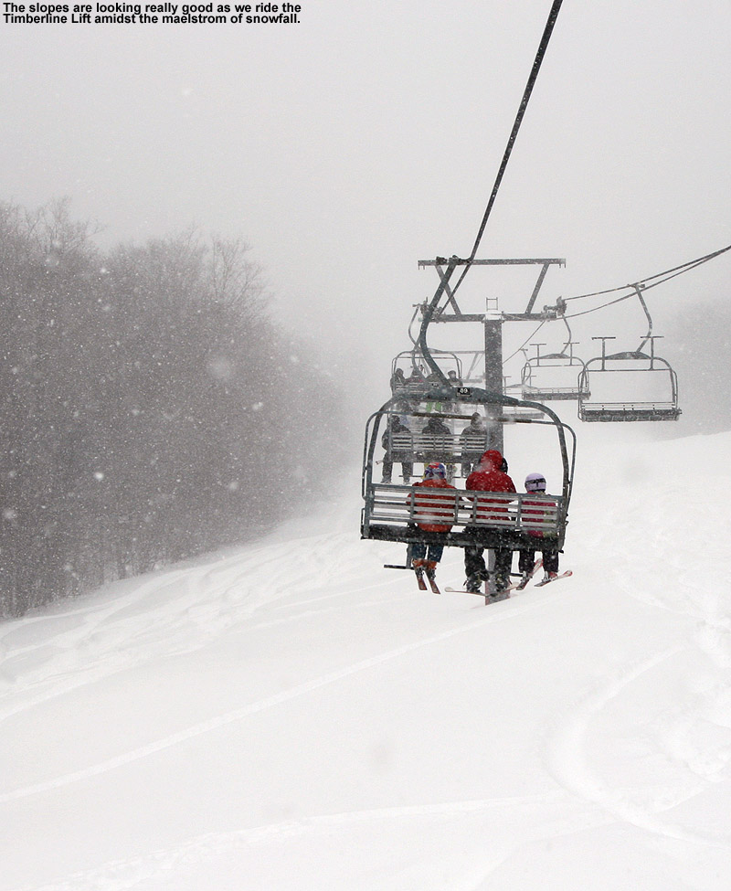
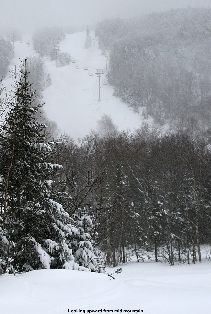
I had just topped out around 3,100’ on a backcountry ski tour this afternoon when I got a text indicating that we’d been put under a Winter Weather Advisory. That was fun timing. Anyway, I’m seeing roughly 4-8” or so in our point forecast through Tuesday night, and that seems to correspond fairly well with the yellow 6-8” shading there have here along the spine. The most recent BTV NWS maps are below.

-
With the additional overnight snowfall, Bolton was reporting a total of 9 inches from Winter Storm Gerri as of their early morning report. And, since the Timberline Quad didn’t open yesterday due to winds, today would also be its inaugural run of the season, so the chance to visit the Timberline terrain that nobody has really skied at all up to this point was a nice bonus.
Based on the conditions I encountered yesterday, I really expected the main mountain to offer the best conditions, especially above 2,500’ where the snow was never too wet, but there was always the chance that Timberline would surprise us due to all the fresh snow. After our first lift ride on the Timberline Quad, it actually had to go off line for a time due to a mechanical issue, so heading to the main mountain turned out to be the appropriate option anyway.
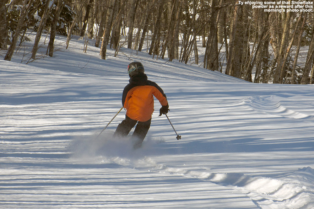
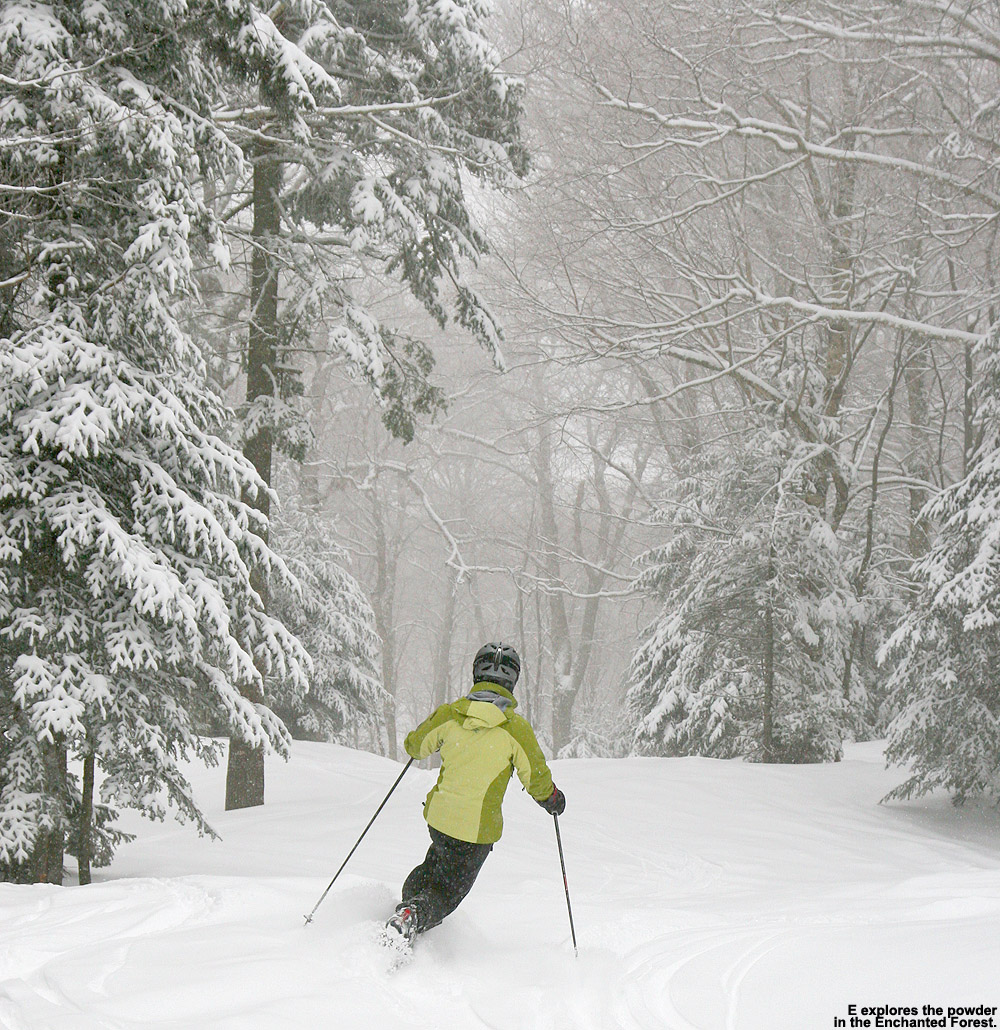
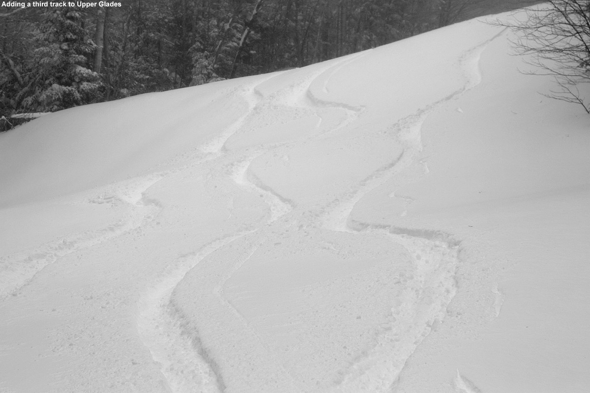
Not surprisingly, there were a lot of fresh tracks to be had out there today, but I’d actually say the snow quality below 2,500’ was a notch below what it was when I was out yesterday afternoon/evening. Yesterday I was skiing in 6 to 7 inches of powder off Snowflake, but the bottom few inches of that snow must have still be fairly wet at that point because we found it had thickened up with today’s cooler temperatures. So, it meant that today we were only skiing in the top few inches of powder and contacting that denser snow below if you pressured hard enough. As long as you had untracked snow, it was nice skiing, but it certainly wasn’t as bottomless as yesterday in those lower elevations. Areas with previous skier traffic ended up with uneven subsurface that definitely detracted from the quality of the turns. Thankfully, the dense snow didn’t form anything like a breakable crust, which would have made the skiing much more challenging. On our return trip to the Timberline Base, we did get first tracks down the lower half of Tattle Tale, and that was really sweet, even if the powder wasn’t as bottomless as it would have been yesterday.


-
Below is the north to south listing for the final snow totals from Winter Storm Gerri for the Vermont ski areas that provided reports. There was certainly a lot of variability up and down the spine with this one, and no obvious north to south trends. The best hits seemed to be in the Bolton-Stowe stretch and around Killington with 9 to 10 inch totals.
Jay Peak: 6”
Burke: 2”
Smuggler’s Notch: 5”
Stowe: 9”
Bolton Valley: 9”
Mad River Glen: 3”
Sugarbush: 5”
Middlebury: 2”
Saskadena Six: 1”
Pico: 10”
Killington: 10”
Okemo: 6”
Magic Mountain: 4”
Stratton: 4”
Mount Snow: 7”
-
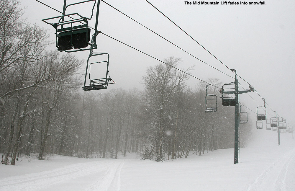
Over the past week, the weather pattern has featured these larger systems with ample snow and moisture, and the most recent one in the series is Winter Storm Gerri. It moved into the area overnight in the wee hours with an initial burst of heavy snow. The front end snow in this case wasn’t as potent as it was with Winter Storm Finn that came through midweek, so when we saw that Bolton Valley was indicating only 2 inches of new snow in their early morning report, we knew there was no need to rush right up to the mountain.
We watched the Bolton Valley Base Area Webcam through the morning and could see that up at 2,100’, the precipitation was snow, and it was quite heavy at times. My younger son and a friend headed up in the early afternoon, and we asked them to give us an update on what they found. Their impressions were that the snow surfaces were rather wet, and they said the precipitation was even mixed with rain in the lower elevations at times, so my wife figured that instead of skiing, she’d hold off until the snow got better. I took another look at the webcam feed and saw that there was heavy snow falling, and decided that it would definitely be worth it to head up for some lift-served runs.
Heading up the Bolton Valley Access Road, the precipitation switched over to all snow at roughly the 1,000’ elevation, and above that the road was quickly covered. The road conditions must have been getting a bit slick with the new snowfall because I had to drive around a van that was stuck trying to make it up the steep s-curve below Timberline. I had actually planned to park at Timberline and start my session there, but the Timberline Quad was apparently on wind hold, so I had to continue on up to the main base area. I arrived up in the Village to very heavy snowfall in the 1 to 2 inch per hour range, and with the intensity of that snowfall, there was just no way that the turns weren’t going to be great.
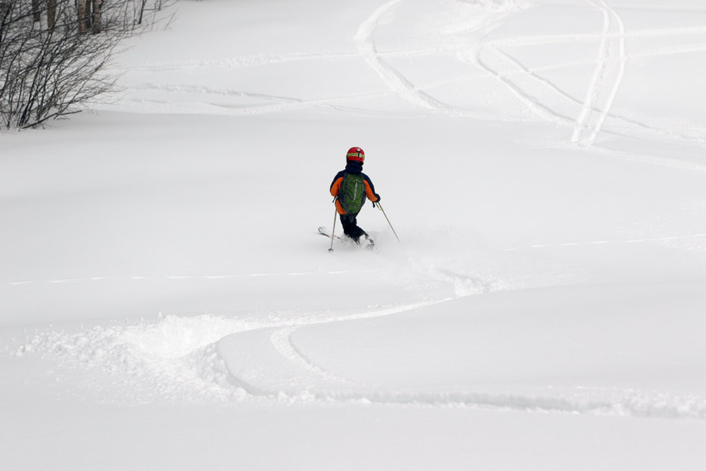
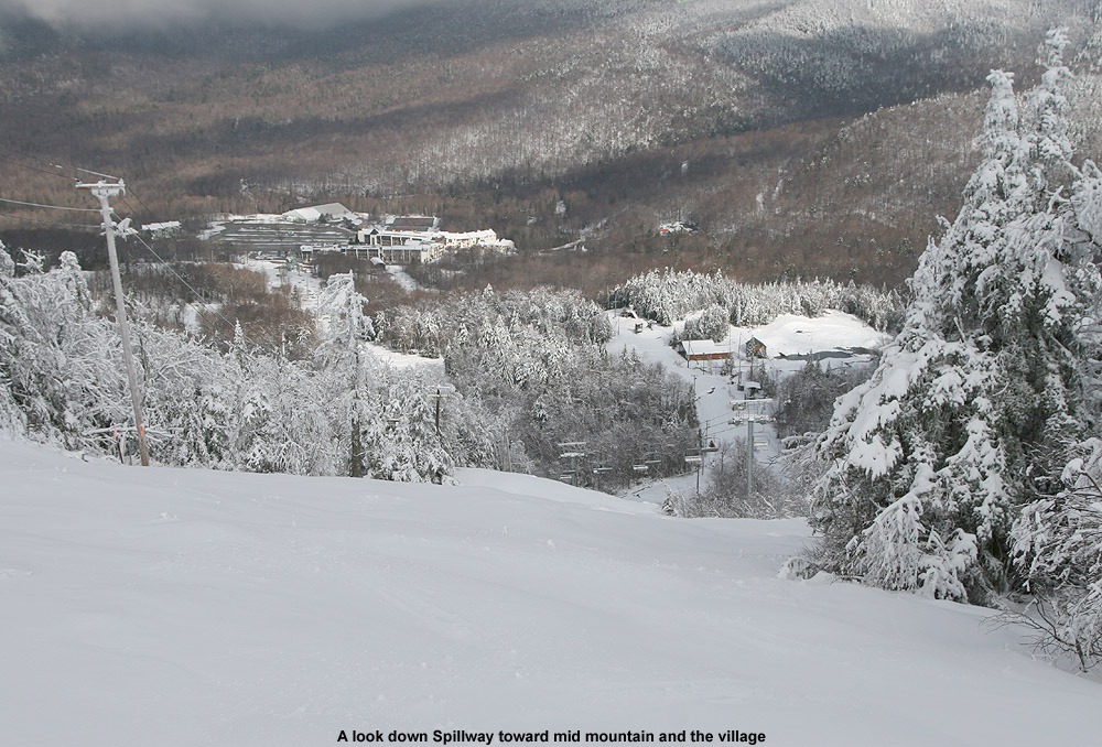
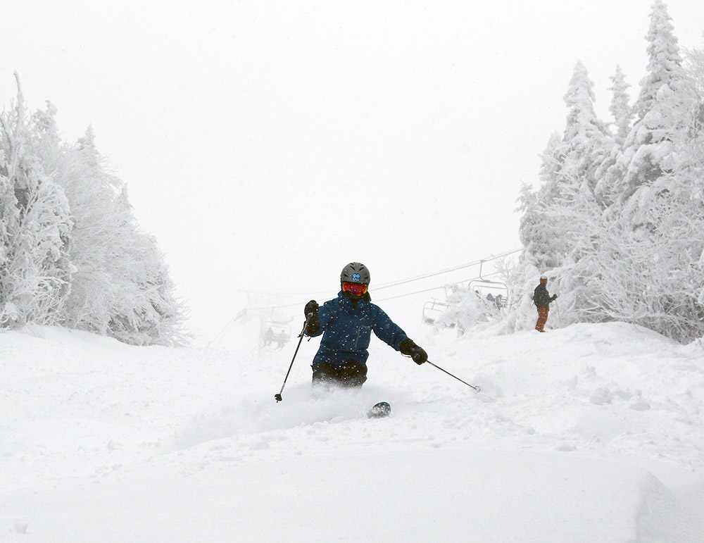
During my afternoon session I managed to get in runs on all the rest of the lifts, and heavy snow continued to pound the resort at all elevations. It was windy, especially at the Vista and Wilderness Summits above 3,000’, but thankfully the wind was from the west and at your back while you rode the lifts. After my first couple of runs, the lights were coming on, and I got to ski Spillway in night mode. I always find it exciting to be able to ski something that steep at night, and I knew that the conditions on Spillway were going to be really good because you couldn’t hear anything from the skiers and snowboarders below you as you passed over them on the Vista Quad. Indeed, my own experience on the trail revealed that the conditions on Spillway were simply fantastic. New snow was falling so fast that it must have been covering up an slick spots faster than skiers could push the snow away.
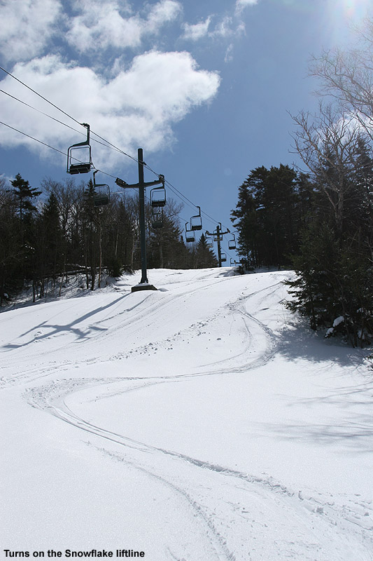
I did notice that below the Mid Mountain elevations (~2,500’), the groomed/packed ski surfaces did have that “wet pack” feel that I’ve encountered in the lower elevations of Whistler Blackcomb. That’s usually a sign that some very wet snow has fallen and was packed by skier traffic. I could see what my son was talking about with respect to the wet surface conditions, but at the point that I was up there, those conditions were hard to find because temperatures were falling, and it was snowing so hard that those types of wet surfaces were covered up in all but the highest traffic areas. Some of the best turns I found were near the end of my ski session when I visited the Snowflake Chair. That area hadn’t seen much skier traffic, so I found a lot of fresh powder that skied beautifully. I did numerous depth checks and was consistently getting new snow depths of 6 to 7 inches. There was enough powder there that I questioned whether it was all from just this storm, but when Bolton’s afternoon snow update came in and they were reporting storm totals of 5 to 7 inches, that nicely corroborated my measurements.
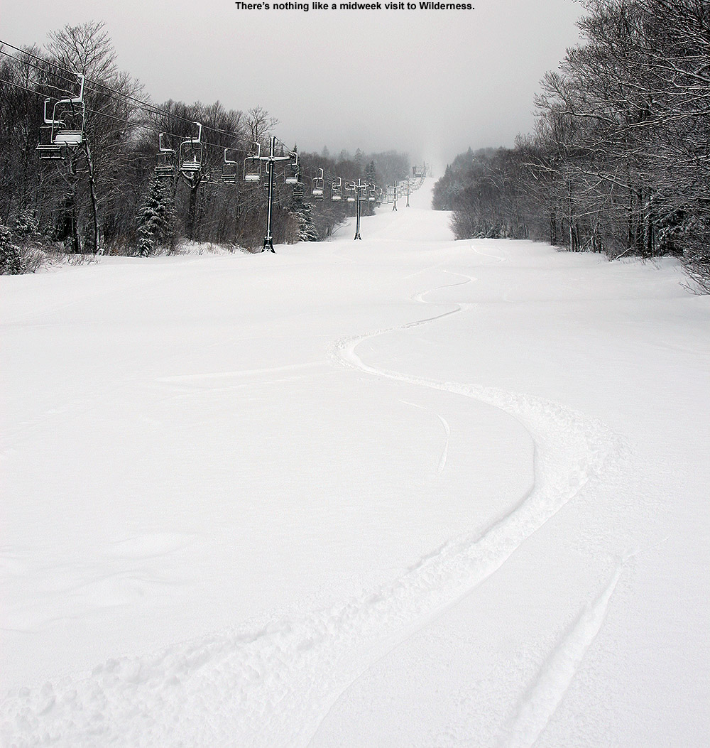
All this new snow is a great addition to the snowpack, but even without it, one thing I noticed while out on the mountain today was the huge jump that the snowpack has taken since last weekend. I hadn’t been up to the mountain since Sunday, and at that time, patrol was just starting to open up more areas of natural snow terrain as coverage improved thanks to Winter Storm Ember. The contributions made by Winter Storm Finn must have been huge though, because the resort has now been able to open up just about everything, and everywhere I looked this evening, coverage felt like midwinter. As I look back now at my storm data, I guess I see the difference – Winter Storm Ember dropped 0.69 inches of liquid equivalent here at our site, while Winter Storm Finn dropped 1.99 inches of liquid equivalent. That’s almost triple the amount of liquid, and when you get up around 2 inches of liquid equivalent, that starts to become a serious resurfacing of the slopes. Winter Storm Gerri has already dropped about an inch of liquid equivalent here at the house, and the back side snow is still coming through, so that’s simply adding yet another great layer to the snowpack. All told, this past week of storms has dropped almost 4 inches of liquid equivalent here at our house in the valley, so it must have put down at least 4 to 5 inches of liquid equivalent for the mountains. When I look at the numbers, I realize now why the snowpack seems to have improved so much so quickly. When I was riding the Wilderness Chair today, I actually saw a ski patroller skiing the headwall of the Wilderness Lift Line to check the snow. You know the snowpack is getting decent when that headwall is even close to being skiable, so the fact that he was even testing it speaks volumes about how things have gone over the past week.


-
 4
4
-
-
Below is the north to south listing of available snow totals from Winter Storm Gerri thus far for the Vermont ski areas that have made end-of-day snow report updates. I didn’t see any late day updates for the southern half of the state, but up to this point the storm has delivered about a half foot or so of snow, with totals appearing to taper down a bit for the most northern areas.
Jay Peak: 4”
Smuggler’s Notch: 3”
Stowe: 7”
Bolton Valley: 7”
Sugarbush: 6”
Pico: 7”
Killington: 7”
-
On 1/9/2024 at 6:02 PM, dmcginvt said:
What a wild place you live in. I have been paying attention to your measurements for years but especially since I lived in the Village from 2015-2018, and since I've live on Gregg Hill at 820ft since 2019. In the village I never beat you, you always had more. But since 2019 at GH in a few elevation events I beat you handily, but I do see looking at point forecasts that they are calling for 3-7 for me and 4-8 for you. Of course my old village location shows 4-8 too. Snowing nicely out there right now that's for sure and we are nowhere near the meat for a few hours., The microclimates of Vermont intrigue me. The Garfield Section of Hyde Park/Moville/Wolcott the most. It's a magical place
Yeah, the microclimates around here are simply amazing – sticking a 4,000’ wall of mountains at this latitude, along with all the extra nooks and crannies of the local sub-ranges, with substantial moisture sources to the east and the west and all the different types of weather systems we get… it’s an incubator for interesting weather.
This morning was a classic example of the localized and frequent weather around here. It was snowing and accumulating at observations time this morning, and it took me a while to figure out its origin. It was too far removed from the back side of Winter Storm Finn to put it there, and too far ahead of the shortwave that’s supposed to come into the area this afternoon to be assigned to that system. The BTV NWS forecast discussion mentioned the snow around, but didn’t assign it to any specific weather feature. Eventually, after some analysis of the models and radar, I simply had to attribute it to moist westerly flow off Lake Ontario. Mother Nature seems to love to squeeze in extra weather events around here.
And indeed as you noted, this area around here is a local hotspot for snow – that was one of the first things that a neighbor told me when I moved here. Folks like PF and mreaves have pointed out how there are just a lot of reasons: we’re at roughly the pass/high point here through the Winooski gap, so we get the convergence that comes with the gap, plus a bit of extra boost with the elevation rising out of Bolton Flats. There’s not a lot of downsloping here, and being just about in line with the spine, the area can get in on both east side and west side events. We’re also just enough on the east side of the spine so that there’s a decent amount of protection from the warm air intrusions from the west. The only attribute that’s not really present in this area is additional elevation as you noted. At times, this part of the valley sort of punches above its weight in terms of elevation because of the apparent cooling that can come from the forced ascent off the terrain in dynamic situations, but that’s not always going to cut it, and sometimes the snowfall will be lower/wetter just as you’d expect for being in the lower reaches of the Winooski Valley.
-
1
-
-
Below I’ve put together the north to south list of what I’ve seen reported for Winter Storm Finn snow totals from the Vermont ski areas. It looks like totals were in the 6” range for the southern ski areas and ±12” along the spine in the central to northern ski areas.
Jay Peak: 13”
Burke: 6”
Smuggler’s Notch: 8”
Stowe: 10”
Bolton Valley: 10”
Mad River Glen: 12”
Sugarbush: 9”
Middlebury: 6”
Saskadena Six: 5”
Ski Quechee: 8”
Pico: 10”
Killington: 10”
Okemo: 10”
Bromley: 6”
Magic Mountain: 6”
Stratton: 6”
Mount Snow: 6”
-
2
-
-
-
This afternoon I received a text alert that we’d been put under a Winter Weather Advisory in association with the approaching system that has been given the name Winter Storm Finn. Our point forecast suggests accumulations in the 4-8” range through Tuesday night, and the Storm Total Snowfall Forecast map has us in that yellow 6-8” shading, so those seem in general agreement. The current maps are posted below:


-
Below I’ve put together the north to south list of what I’ve seen reported for Winter Storm Ember snow totals thus far from the Vermont ski areas. Although the initial forecasts suggested heavier accumulations for the southern part of the state, overall it looks like storm totals were fairly consistent up and down the spine, coming in ± about a foot of snow.
Jay Peak: 12”
Burke: 9”
Smuggler’s Notch: 13”
Stowe: 10”
Bolton Valley: 12”
Mad River Glen: 9”
Sugarbush: 8”
Middlebury: 13”
Pico: 8”
Killington: 8”
Okemo: 13”
Bromley: 11”
Magic Mountain: 9”
Stratton: 10”
Mount Snow: 9”
-
Winter Storm Ember began to affect the area last night, and Bolton Valley was indicating that an additional 3 to 4 inches of new had fallen as of their early morning report. My wife and I headed up with our older son a couple hours later to catch the opening of the lifts, and there were probably a another inch or two by that point because it was snowing at a decent clip. Even more notable though was the wind – it was easterly and quite strong, and it was hitting you right in the face while riding the Vista Quad. Combined with temperatures in the teens F, our storm gear was definitely earning its keep and was highly appreciated.
Based on my analyses from the house, the mountain had seen probably about a half inch of liquid equivalent by that point. Combined with the several small storms we’ve had over the past week as we’ve kicked off January, it was a decent contribution to resurfacing, but certainly not at the point where patrol could simply drop the ropes on all the natural snow terrain. The snow was enough to open up certain natural snow areas like the Enchanted Forest, but at that point of the storm there just wasn’t enough liquid equivalent down to get the steepest terrain going. There was plenty of terrain open to enjoy the fresh powder though, and we knew more trails would open as the storm continued to deliver more snow.
In the late morning our son had to head off to work, but my younger son and some college friends who are staying over for a mini ski vacation were headed up for some runs, so we got to ski with them. The fierce winds from the morning had abated to essentially nothing, so that made the lift rides much more comfortable. A depth check I made around noontime in undisturbed snow at about mid-mountain elevation revealed 9 inches of surface snow, which was probably the combination of what had fallen from this storm on top of the lighter amounts from our other recent storms.
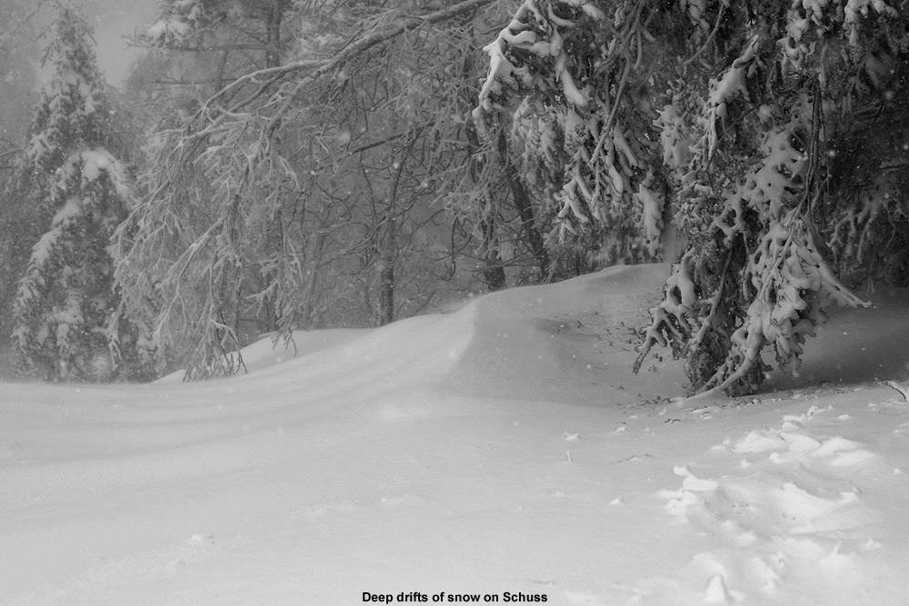
After we left in the early afternoon, I heard that they began to open some steep terrain like Schuss, so the storm was definitely having an impact on replenishing coverage in areas that needed it. The resort was reporting 9 inches of new snow as of closing bell, but with the way it’s been snowing around here this evening, I’m sure they’ll have picked up more by tomorrow morning.


-
1
-
-
With the additional snow that was falling during my Friday evening tour, plus another round that came through the next afternoon, yesterday seemed like another good opportunity to head up to the mountain for a quick ski tour. Snow was falling all the way down in the bottom of the Winooski Valley, and it intensified as I headed up the Bolton Valley Access Road. It was another snowy day, and although none of these past few systems have been huge, the continued accumulations day after day have definitely been having an impact on the quality of the conditions.
Compared to Friday, I started my tour earlier yesterday, and running out of light wasn’t an issue, so I was able to tour up to about 2,700’ instead of just 2,500’. Compared to Friday, the combination of new snow and settling didn’t appear to change the new snow depths too much in the lower elevations, but I definitely noticed an increase starting at around 2,500’, and the depth continued to increase above that level as well. Here’s the comparative new snow depth profiles between Friday and Saturday:
320’: 0-1” --> 0-1”
1,000’: 1-2” --> 1-2”
1,500’: 2-3” --> 2-3”
2,000’: 2-3” --> 2-3”
2.500’: 2-3” --> 3
2,700’: 3-4”
With the daylight, and more time, I was able to choose some alternate areas of Wilderness that had mostly untracked snow. Getting into the untracked snow made for dramatically better skiing, and I was starting to even get into some bottomless turns on the lower angle slopes.
From my tours Friday and Saturday, I found that the water bars on the lower slopes of Wilderness were generally in good shape with respect to coverage, so there shouldn’t be any issues there if they decide to open that are for lift-served skiing. Based on what I’ve seen over those couple days of ski touring at Wilderness, the skiing was already quite decent there and it’s really going to take off with even a few additional inches of snow.
Although Winter Storm Ember has already moved into the area and is currently in progress, I figured I’d get yesterday’s report posted so that people have an idea of where things stood just ahead of the snow from the current system. We did get out for turns in the new snow at Bolton Valley this morning, so I’ll put together an update on that to speak to where we are now in terms of conditions as soon as I get a chance.


-
3
-
-
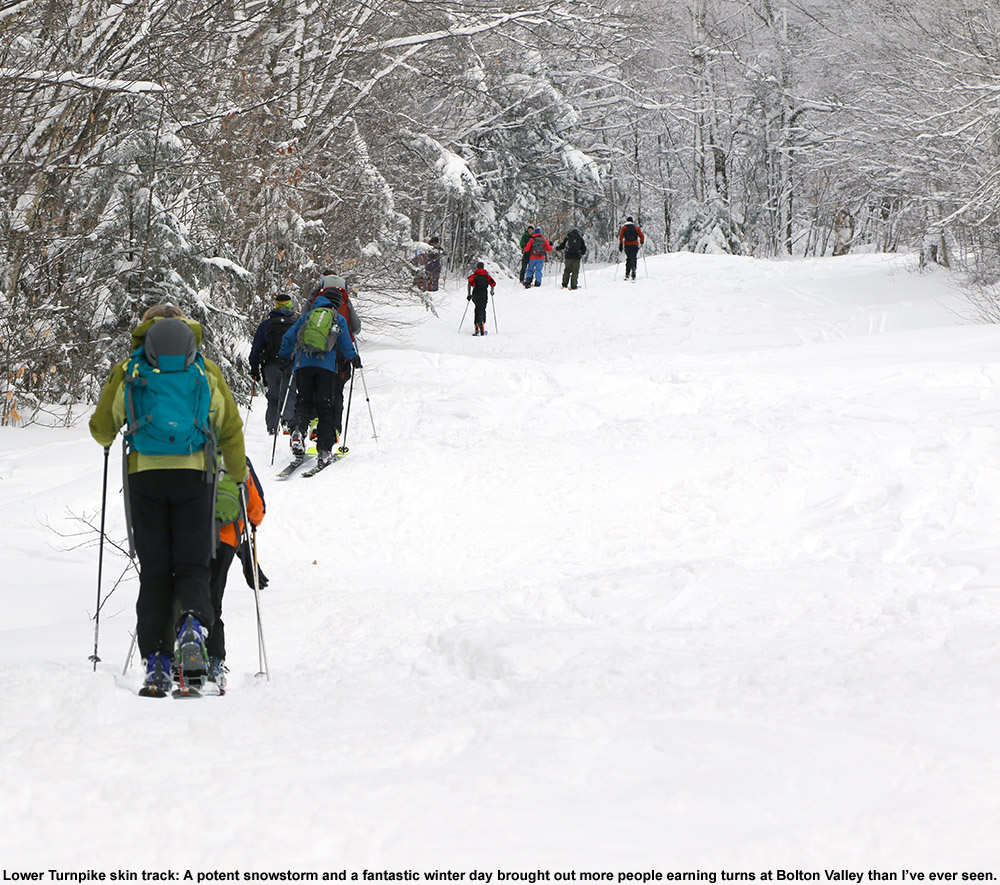
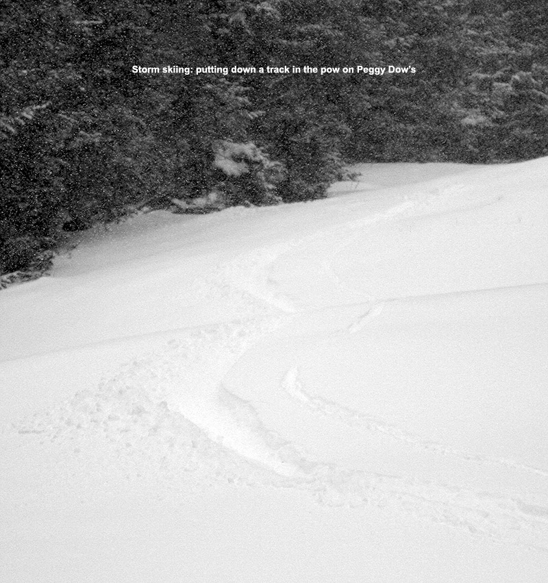
We’re only at the 6th of January, but we’ve already had four minor systems affect the Northern Greens area so far this month in the form of troughs, cold fronts, and localized snow bands. As of yesterday, Bolton Valley was reporting 5 inches of new snow in the past 48 hours, and the snow report also indicated that the Wilderness Uphill Route had been officially reopened up to Peggy Dow’s. I figured that was a good sign that natural snow terrain coverage and conditions were getting back toward something a bit more normal, so I decided to hit the mountain for an afternoon ski tour.
Heading up the Bolton Valley Access Road, snowfall began to pick up with elevation, and there was steady light to moderate snow falling in the Village. I’d left Burlington a bit later than I’d wanted to, so daylight was fading when I started my tour. So, I only had time to tour up to near 2,500’, and I stuck to skiing Lower Turnpike due to the encroaching darkness.
Settled accumulations of new snow that I encountered from the base of the access road up to the top of my ski tour were as follows:
320’: 0-1”
1,000’: 1-2”
1,500’: 2-3”
2,000’: 2-3”
2.500’: 2-3”
As the profile indicates, there really wasn’t much of a detectable increase in new snow depths between 1,500’ and 2,500’. Lower Turnpike was fairly well packed from ski touring traffic, and with the low light, I didn’t venture too far from the middle of the trail, but the surface was relatively soft and quiet. The turns certainly weren’t bottomless since I was mostly on the skier packed snow, but I did manage to find some untracked areas toward the edges, and those were very nice.
The snow that was falling was definitely accumulating – even after a relatively short tour, I had to clean off my car when I got back to it. The snowfall did taper down in intensity as I descended back into the Winooski Valley, but even at the valley bottom we were still getting some accumulation.


-
3
-
-
43 minutes ago, EMontpelierWhiteout said:
With Winter Storm Warning now posted for my neck of the woods in North Central VT, looking forward to getting solid snow cover back in the yard. My new cross country skis have gotten little use.
I see that the BTV NWS has pushed the Winter Storm Warnings farther northward to here in Washington County, and they mention it in their most recent discussion:
National Weather Service Burlington VT
413 PM EST Sat Jan 6 2024
NEAR TERM /THROUGH SUNDAY NIGHT/...
As of 400 PM EST Saturday...Some light snow has occurred today with some shortwave energy out ahead of approaching system, accumulations have been light. A more significant weather system is approaching out of the southwest tracking just south of the North Country overnight. This system will bring widespread accumulating snow. Models show low staying tucked in tight along the coast, and northward shift in precipitation continued with this latest forecast package. Deep moisture and strong forcing across our region, still looking at snow ratios around 14 or 15 to 1. With latest update added 1 county to the warning and expanded the winter weather advisory to cover our entire area.
Their newest Event Total Snowfall map does extend that 8-12” shading up here to our area of the spine, and the latest maps are below:


-
Following up on mreaves post above, early this morning a text cam in indicating that we’ve been put under a Winter Weather Advisory here in our area. The point forecast here at our site suggests storm accumulations in the 6-10” range through Sunday night, and that seems to be a bit of a bump from where things were at yesterday’s update. That trend seems apparent in the Event Total Snowfall maps below.


-
10 hours ago, powderfreak said:
7.5” and coming down on mid-Mountain Road. Not fluff… pasty stuff. Theres some QPF in this.


The BTV NWS did put out a special weather statement for the event (text below) to alert drivers passing through the area. The Waterbury band has shifted its angle and pushed south a bit, so we’re catching the edge of it at our site at the moment.
US National Weather Service Burlington VT
[1 AM] Happy New Year! It's still snowing in Stowe and Waterbury, with reports of localized 6-8 inches of snow in the past 24 hours. If you are traveling in central VT tonight, be ready for changing conditions especially on Route 108/100 and I-89. : Vermont Agency of Transportation & Scott Braaten #vtwx
National Weather Service Burlington VT
700 AM EST Mon Jan 1 2024
.NEAR TERM /THROUGH TUESDAY/...
655 AM UPDATE...
…and of course, we have to talk about the snow that wouldn`t quit along portions of Route 108 in Stowe as well as Route 100/I-89 near Waterbury. It`s still snowing and according to reliable reports, over 6 inches to locally 8 inches have fallen in the past 24 hours. Just an incredible microscale overachiever with bare ground just a few miles away. So the main change to this forecast package have been to increase PoPs to likely/numerous shower coverage range. Given the quasistationary nature of the narrow band, expect locally an additional 1-2 inches of snow on top of what has already fallen. While not everyone will see winter driving conditions or snow, be prepared for changing conditions and stay alert if driving across central VT during the pre-dawn into early morning hours.
Special Weather Statement
National Weather Service Burlington VT
1214 AM EST Mon Jan 1 2024
VTZ006-008-017-011400-
Lamoille-Washington-Eastern Chittenden-
Including the cities of Johnson, Stowe, Montpelier, Waitsfield,
Richmond, and Underhill
1214 AM EST Mon Jan 1 2024
...Localized persistent narrow band of snow impacting Central VT...
A localized persistent narrow band of snow has led to locally over 6 inches of accumulation over the last 24 hours along the Route 108 corridor in Stowe as well as portions of Route 100 and Interstate 89 near Waterbury, VT. Not everyone will see snow or experience winter driving conditions. However, if you are traveling in the area, be alert for changing conditions and give yourself extra time to reach your destination.
Precautionary/Preparedness Actions...
Slow down and use caution while traveling.
Please allow extra time if traveling.
-
3 hours ago, powderfreak said:
...super weird localized event. And it wasn’t like fake fluff. It was dense cake.
Thanks so much for these updates PF – if you’re not out and about in the right areas, or happen to catch wind of this from someone telling you, one could easily be totally oblivious to this. I bet even around here locally in the Northern Greens, most people aren’t aware of this snow. Bolton is reporting 3 inches of new snow in the past 48 hours, but that’s been a more gradual accumulation and not this concentrated snowfall. As you mentioned, the mountains aren’t really getting this, so it’s not going to show up in the snow reports.
I heard about the snow in Stowe from your posts, but it turns out there’s a similar event going on in Waterbury as well. We were shopping at the Waterbury Shaw’s, and we suddenly realized that there were a couple inches of fresh snow on the ground. Some cars in the parking lot had substantial amounts of snow on them as well – we saw one car from New Jersey that had 6 to 8 inches of snow on its roof, so we figured it must have come from the Stowe area.
It was snowing some nice flakes when we came back out of Shaw’s, and the snow is so localized that as soon as you cross over I-89 heading into the village of Waterbury… there’s nothing. It looked like the Waterbury Shaw’s/Colbyville area was toward the southern end of that streamer, so I was curious to see what Mother Nature had in store when I headed north toward the Waterbury Lake Champlain Chocolates to get some lattes. I could see that the radar was showing a streamer in that area. It was snowing north of Colbyville at that point, and it looks like the greatest accumulations thus far are just a bit north of the Waterbury Ben and Jerry’s with about 3 to 4 inches on most surfaces. There’s a good covering of at least a couple inches all the way past the Cabot Creamery Store/Lake Champlain Chocolates area, and then once you get to Cold Hollow Cider Mill, accumulations simply drop down to nothing. So like your reporting from the Stowe area, accumulations around here in Waterbury are quite localized.
Indeed we’ve had these sort of mountain wave events before as you mentioned – I think last time when I was looking at the radar, the Stowe band seemed to be off Mansfield, and the Waterbury one was off Bolton Mountain. It wouldn’t surprise me if it was similar this time - very cool stuff.

-
2
-
-
As of mid-December, Bolton had already reported 100 inches of snow on the season, and with most of that falling from mid-November onward, it created a solidly snowy stretch. That period offered a ton of great skiing here in the Northern Greens, so the end of November into the first couple weeks of December was quite a whirlwind of trying to make time to get out for turns while also finishing up the busy fall semester period. It’s always best when the snowstorms keep rolling through, but when snowfall slowed down during the mid-month period, it was actually nice to be able to finally catch up with everything else in life that had been put on the back burner due to all the time spent out on the hill.
The family has been able to catch our breath the past couple of days after a busy period of holiday activities, and since I’ve been hearing about the nice soft conditions out there on the local slopes, my wife and I decided to head up to the mountain for some turns this afternoon. The snow report indicated that skier traffic was fairly light today, and I guess that makes sense – with no major snowstorms in the past week or so, there’s really no pressure to run out immediately and get after the fresh powder, so I assume a lot of folks have taken the same approach we have. We watched the Bolton Valley Base Area Webcam for a while today and could see that skier traffic was indeed fairly light.
We arrived at the mountain in the mid-afternoon period, and the top tiers of the parking lots were fairly full, but there were some open spots in the first lot due to folks who had already left. We often find that this ends up being the case around mid-afternoon because some people have left, and you’re still ahead of the bump in visitors that arrive as night skiing kicks off.
Skies were mostly cloudy with a few breaks of blue when we started our session, and the top of Vista Peak from about 2,800’ on up was hidden in the clouds. Temperatures were in the upper 30s F, and there wasn’t any wind in the lower elevations, so it was a very comfortable time for suiting up at the car. Even with temperatures in the just the 30s F, the snow was soft at all elevations because it’s been warm enough over the past couple days that the snow isn’t freezing up too thoroughly. You can find some firm patches out there in high traffic areas, but most of the snow is loose, pliable, and nicely carvable.
I was quite impressed with the number of trail options available from the Vista Summit. I remarked to my wife that compared to when I was last up there on the 12th after one of our larger storms, there are actually a lot more options now. Back at mid-month, many routes were closed due to snowmaking and ski patrol marking obstacles, but with the colder temperatures following that storm, the resort was able to finish up their snowmaking and open up those routes. So while natural snow trails like Vermont 200 that were open at the point are closed because the coverage isn’t quite there, steep favorites like Spillway and Hard Luck are now available with deep coverage thanks to snowmaking. Alta Vista was also open, and I don’t think that’s been open yet on any of the days I’ve been up on Vista.
We heard a lot of foreign accents around the base area and out on the slopes today, so it seems like Bolton has a good number of international visitors for the holiday week. Indeed skier traffic was fairly light, but lively enough, so the folks who are visiting are getting quite a good mix of soft snow, comfortable temperatures, winter holiday vibes, and elbow room on the slopes. This is a blackout period for folks who have restricted season’s passes, so that’s probably helping to reduce holiday week skier numbers a bit as well.
With the late December daylight period, the night skiing lights were already coming on by about 3:00 P.M. or so, and as we were leaving a bit after 4:00 P.M., low clouds rolled into the base area dramatically, just as I noticed a dense fog advisory on my phone. The fog moving in with the night skiing lights definitely pumped up the solstice vibe at that point.
Tomorrow might be the last day to catch this soft snow, because it sounds like snow and colder temperatures are in the forecast starting tomorrow night. With that shift we’re going to need to get enough fresh snow down to get back to soft skiing, but at least the dividends of all those early season winter storms are still present in the form of the snowpack in the higher elevations. It won’t take too much new snow to get a lot of natural snow terrain back in action, so we look forward to Mother Nature helping out soon.


-
6
-
-
On 12/13/2023 at 5:29 PM, eyewall said:
Yeah Lightroom is pretty solid for handling those casts etc. I used that for the recent snow in the NC Mountains:
Indeed, that's certainly what I'd use if I didn't already have Photoshop - Adobe knows their stuff.
-
1
-
-
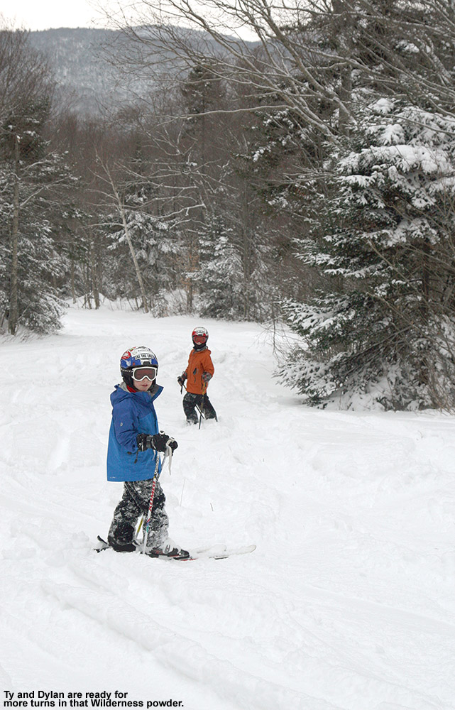
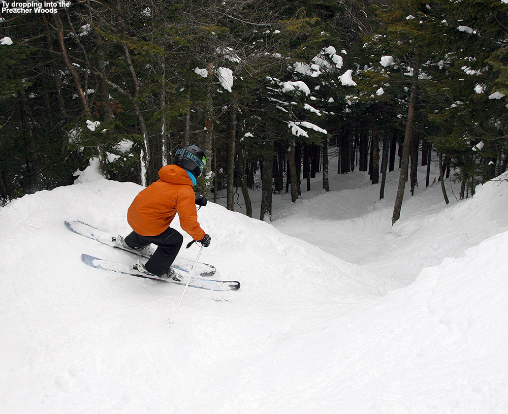
I haven’t been up to the mountain since Tuesday, but my younger son was out for some lift-served turns on Wednesday with friends and he said that Bolton’s conditions were fantastic. Similar to what I’d observe on Tuesday, he said there was a still a lot of roped terrain due to various hazards, but he and his group were able to ski lower down on Preacher, and the untracked powder was going strong. That area is well protected from winds, and with the lower traffic due to the current need to traverse in, he said that conditions in there were better than he often sees in midwinter. The resort had also opened up the lower part of Wilderness that can be easily accessed from Vista, and he said the powder there was excellent as well.
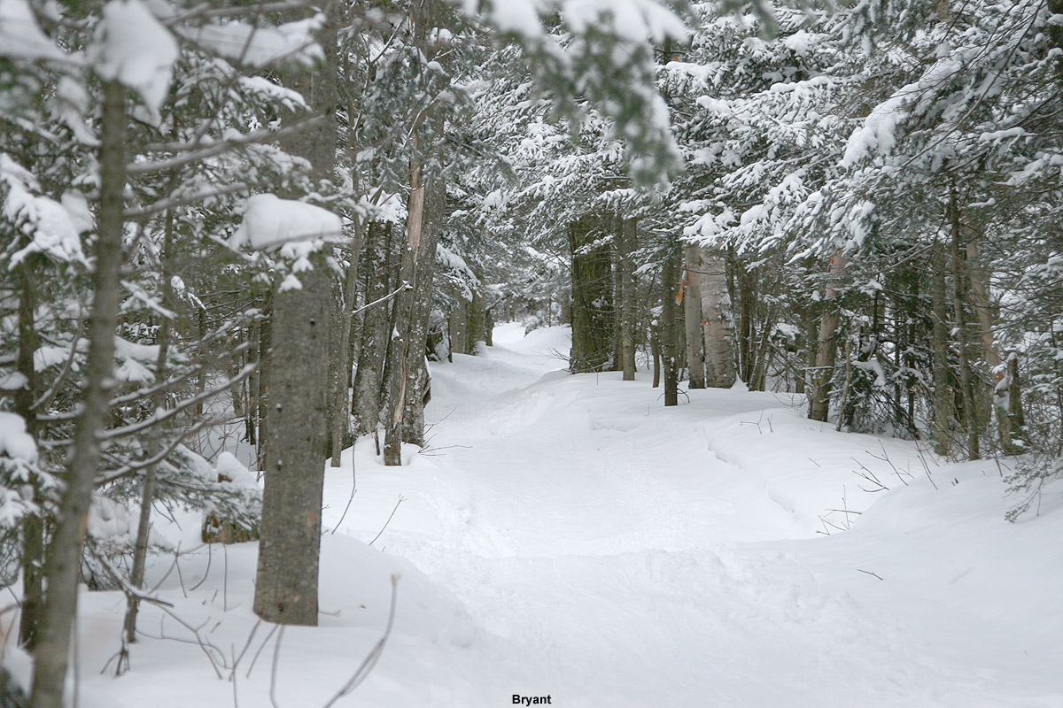
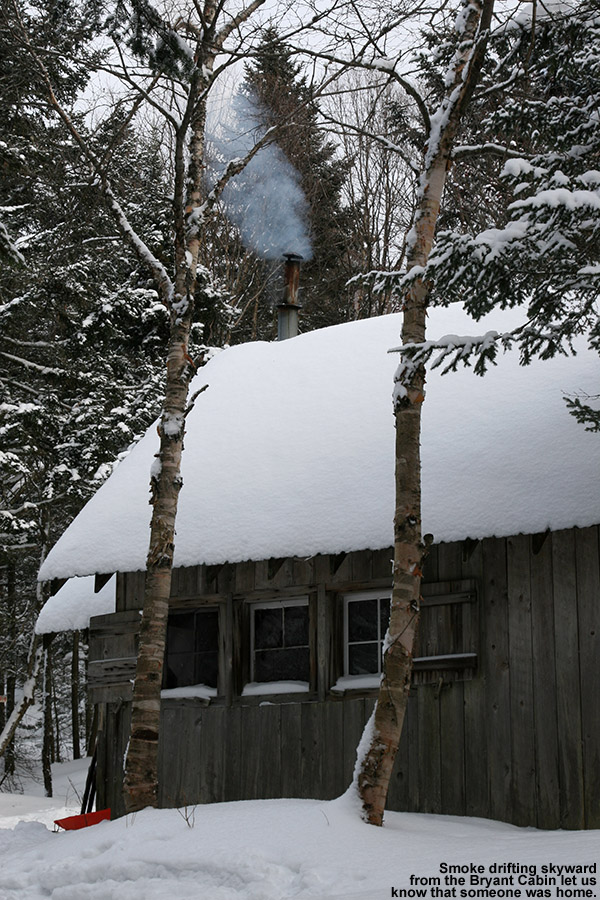
Since it hasn’t snowed for a couple of days, I decided that the timing would be good to head out onto Bolton’s Backcountry Network. This was my first time out on the Network this season, so it was a great opportunity to see where the snowpack stands. In terms of skiing the glades, coverage is quite good, and there are no major issues there. Out in the glades is feels like something that is approaching a midwinter snowpack, but what gives it away that we’re not quite there yet are the water bars on the main access trails. Some water bars are fine, but there are many that seem like they are stuck in early season, probably because they got blown out a bit by the warm start to the last system. I haven’t noticed that issue quite as much on the lift-served terrain, probably because the grooming and greater skier traffic help to pack in the water bars more, but those factors aren’t there to tamp down the snow down on the backcountry terrain. There are a number of spots on the Bryant Trail where people have diverted the skin track around the water bar area instead of trying to bridge it.
Today we toured up the classic route to the Bryant Cabin, and then descended through some of the more popular glades. I was surprised to find that even above 2,000’ the temperature was edging above the freezing mark, so the snow was getting a bit thick in some areas. This effect seemed to diminish with elevation, and thankfully most of the powder skied well and wasn’t sticky, probably because the air is still fairly dry. As we descended below 2,500’, we started to run into areas where the powder became sticky, and I figured it was due to elevation, but we got back into nice powder in lower areas and that makes me think the stickiness was just in areas that had seen the sun. In any event, even with the temperatures being a bit marginal, there’s still plenty of good powder out there at elevation if you avoid areas that got hit by the sun.
It’s not surprising that the backcountry snowpack is getting a midwinter feel, because the snowpack depth at the Mt. Mansfield Stake is at 40 inches, and that’s the depth at which people start to feel comfortable skiing most off piste terrain around here. Those water bars in certain areas do seem to give it away that we’re still in early season though. Bolton’s snow report indicates that they are just shy of 100 inches of snow on the season, and I see that Jay Peak is reporting 115 inches on the season, so both resorts seem to have done well with these early season storms we’ve had thus far. We’re within a couple inches of average snowfall to date down at our site in the valley, but I bet those numbers from the resorts are ahead of their average pace due to the substantial elevation-dependence we’ve see with these recent systems. In any event, 100” of snow by mid-December is a solid start to the season, even at elevation in the Northern Greens.


-
3
-
-
On 12/11/2023 at 10:57 PM, powderfreak said:
Love this. Shows the parking lot vibe.
The black and white shots on these days show what is important. White is snow, non-white is everything else.
Yeah, B&W is especially fantastic for snow photography – if there’s any weird color cast from poor white balance, strange natural lighting, or whatever, you immediately ditch that and it nails the perfect white once you’re done with level adjustments. The auto balancing in Photoshop is pretty fantastic at nailing the white balance in color photos almost all the time anyway, but going to B&W is basically fool proof in that regard.
Beyond the technical side though, B&W is just perfect for contrasting light and dark, and that’s such a huge part of so many snow photos. Storm days, late days, low light days, and certain parts of the mountain are basically B&W to begin with, so going that route is a natural fit. B&W really just fits so well with the typical snowy, winter vibe of the mountains around here.

-
1
-
-
With Monday night’s continued snowfall on the back side of the system, Bolton Valley reported 18” for their storm total in the morning. Since I’d missed out on the chance for any lift-served turns on Monday due to the power outages, I popped up to the mountain for some runs yesterday morning since power was fully restored and the lifts were back in action. The resort is still somewhat in early season mode though, and they’re not running all lifts on weekdays, but the Vista Quad was running, which serves the bulk of the main mountain’s terrain. I haven’t been up to Vista at all yet this season, so this was a chance for me to see how the snow was doing up there.
The resort obviously got a boatload of snow from this most recent storm, with another excellent shot of liquid equivalent for the snowpack thanks to all the dense snow that fell on the front end of the storm. Even with all the snow, there was a ton of terrain that was roped off yesterday morning. The snow report indicated that between the warm front end of the storm and winds that came through, there were areas of water bars, melting and scouring that need some work to be safe for skiers. I’m sure ski patrol will be working hard to open as much terrain as they can as they have time to sort it out.
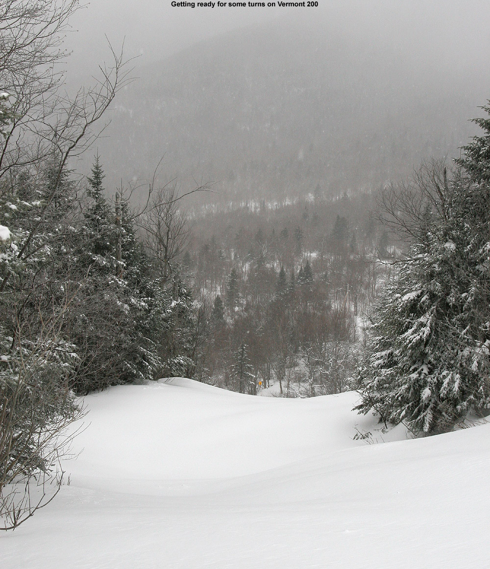
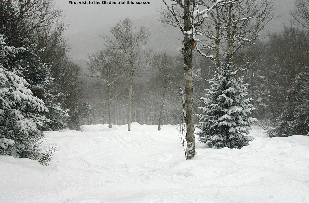
The standard snowmaking/groomed routes off Vista were definitely the main pipeline of open terrain, and the snow report noted that nothing else had been groomed. While so much terrain was roped off, there were some gems that had made the cut, such as Vermont 200 and Glades. I think Vermont 200 is sheltered enough that it holds the snow despite strong winds, and let’s just say, without any grooming, it was a great example of how spicy the terrain is out there. Vermont 200 normally has a lot of contour with plenty of rocks and ledges and stumps and dips and all that, but it feels exaggerated 10-fold with the current snowpack. There is plenty of snow in there though, and it’s a wild ride. Glades was another gem because the Mid Mountain Chair wasn’t running, so getting to the top entry of Glades meant a bit of skating was required across the Mid Mountain Flats, and most people weren’t interested in that. So, the top of Glades had seen very few skiers and held a lot of fresh powder. Lower down, people were coming in from Upper Glades/Moose Run, so the conditions were more tracked, but still excellent.
The snowmakers were out working hard on Spillway, so that seems to be where they’re putting their efforts for additional manmade snow at the moment. Even with all this new natural snow, Spillway still needs that snowmaking base because it’s wide and exposed to the wind so that it’s constantly getting scoured. Additional snow is falling today with the cold front and northwest flow squalls that are coming through, and then it looks quite for the end of the week before a potential larger storm affects the area Sunday night into Monday. The models still seem to have some sorting out to do with that system though.


-
On 12/11/2023 at 8:20 PM, powderfreak said:
Still coming down this evening at the ski area. Don't dare drop anymore obs in the main thread, lol. Getting dire outside of our little pocket in VT it seems.

With the addition of that backside snow from last night, I put together the north to south list of Vermont ski areas snow totals I could find for this most recent storm. Similar to what the modeling suggested, the spine of the Northern Greens seemed to do the best with accumulations. As the numbers show, even for a northern area like Burke, the storm total fell off substantially since they are so far east of the spine. Snowfall dropped off rather sharply for the Central Greens as well, and then there was sort of another tier of drop off south of Killington into the Southern Greens.
Jay Peak: 18”
Burke: 8”
Smuggler’s Notch: 17”
Stowe: 14”
Bolton Valley: 18”
Sugarbush: 8”
Pico: 8”
Killington: 8”
Okemo: 2”
Bromley: 4”
Stratton: 4”
Mount Snow: 2”
-
2
-


NNE Cold Season Thread 2023/2024
in New England
Posted
In this morning’s update, Bolton was reporting an additional 3-5” of snow from yesterday’s lake-effect snow and snow squalls. The other recent snowfall numbers they had in their report looked solid, with 12” in the last two days, 27" since Tuesday night and more than 48” for the first half of the month. The season snowfall for the resort currently stands at 157”, and that’s very respectable since it’s already about half their annual snowfall average when we’re not even halfway through the snowfall season. What makes that pace more impressive is that they’ve had all that snowfall despite the second half of December being quite lean on snow. That really speaks to how much has been falling up there during the snowier periods.
There was no new snow falling today, which was somewhat notable because this morning’s snow report also indicated that if the current forecast for tomorrow’s snow comes through, they’ll be looking at 14 out of the first 16 days of 2024 with snowfall. With today’s break in the falling snow, I figured it was time to head out for a tour on the backcountry network as a reliable route to untracked powder.
I decided to head up the Bryant Trail to Bryant Cabin in the afternoon, and play it by ear depending on how my supply of daylight was looking. I was well ahead of sunset, therefore I just continued on up to the Catamount Trail Glades so I could get in some turns in the higher elevations. Based on my recent outings at the resort, I knew that conditions improved a lot with elevation, so I wanted to get a good sampling of the powder up high. I topped out at an elevation of about 3,100’ on the back side of Bolton Mountain, descended through the Catamount Trail Glades, and then traversed back above Bryant Cabin and navigated a route through another half dozen different glades back to the base. Today definitely had a nice midwinter vibe, with bright afternoon sun, temperatures probably around 20 F, and great powder.
The surface powder and upper snowpack analysis was really interesting today. Starting my tour around 2,000’ in the Village, I found 4-5” of surface powder, and then there was a fairly solidified layer below it. That layer marks the wet snow that recently came from Winter Storm Gerri, which hardened up somewhat as temperatures dropped back below freezing. The surface snow above it is from the snow on the back side of the storm, plus the additional drier snows that have fallen over the past couple of days. As you ascend to higher elevations though, that hard layer gradually begins to soften, and then above 2,500’ it starts to disappear altogether. At that point there is another substantial subsurface layer, which I suspect comes from Winter Storm Finn. So, monitoring the elevation profile for the depths of the powder was bit unusual. Compared to the 2,000’ elevation, I didn’t detect any notable increase in the powder depths at 2,250’, but at 2,500’ it finally started to deeper, and as I continued higher, I could still sort of detect an interface from Winter Storm Gerri, but it eventually became hard to discern. So, what I’ve done for the surface snow depth elevation profile below is to indicate those different layers, with the first depth being snow down to the dense layer from Winter Storm Gerri, and the second being the depth of the snow down to the dense layer from Winter Storm Finn.
2,000’: 4-5”
2,250’: 4-5”
2,500’: 5-6”/8-10”
2,750’: 6-7”/10-12”
3,000’: 7-8”/14-16”
At some point between 2,500’ and 3,000’ that first depth number sort of becomes moot, and you’re essentially skiing in the 8-16” of powder depending on elevation, so go I’d say go in with that mentality. In terms of getting out there in the backcountry around this part of the Northern Greens, I’d recommend touring above 2,500’ if you can for the best turns. I went with mid-fats on today’s tour, but you could easily go with fat skis if you’re going to spend most of your time above 2,500’. When I was up in the Catamount Trail Glades in the 3,000’ range, fat skis would have been nice, except in some of the denser areas of evergreens where they have trapped so much of the snowfall on their boughs, that you actually notice the deficiency of powder below.
The system that is expected to come into the area tomorrow is name Winter Storm Heather, and any snow from that should really be icing on the cake in terms of the ski conditions. Temperatures are forecast to stay cold, so you can pretty much take the powder depths I have above and then tack on whatever new snow comes next.