

cmh90
-
Posts
174 -
Joined
-
Last visited
Content Type
Profiles
Blogs
Forums
American Weather
Media Demo
Store
Gallery
Posts posted by cmh90
-
-
1 hour ago, downeastnc said:
GFS was a smack down for NC..pretty much a Floyd track....
right over my house pretty much...I am sure it will only change 100 more times between now and then, though this run was much faster allowing it to make landfall before getting kicked OTS....

I’ve been watching from a distance for many years and it seems that either the models are becoming less reliable, the weather is becoming harder to predict, or my memory is getting worse.
-
 2
2
-
 4
4
-
-
Tornado warning for Pitt County
-
10 minutes ago, downeastnc said:
I will take the 18Z NAM 3k.....obviously overdone as it has a heavy "band" of snow just sitting over central eastern NC..... but I need it to be right.....

I’ll eat my own shoe if that happens!
-
1
-
-
14 minutes ago, downeastnc said:
Gonna be bad if the HRRR is right....these gust are going to be more vertical and violent as hell....the thing is the band will be narrow you will have a few hrs of 30-40 mph gust then maybe 1-2 hrs of intense wind then 20-30 type gust on the backside of the band.....
How is it looking for our area? No one here is even thinking about it and I have a feeling that some people will be caught off guard.
-
I might be seeing things but it looks like she’s is either moving W or WSW.
-
Is she still heading WNW or has she made the turn yet? It’s hard to tell from the IR with the eye being iffy and all.
-
10 minutes ago, RTPGiants said:
Good IR loop that seems to agree with a north move:
https://www.tropicaltidbits.com/sat/satlooper.php?region=06L&product=ir
We're about to have 1000 arguments over "moving" vs. "wobble" though.
Thank you!
-
2 minutes ago, GunBlade said:
Yea almost took a straight north jump in the last frame or two of the water vapor.
Do you mind providing a link?
-
10 hours ago, zinski1990 said:
957 mb? wow weaker wonder if it drops back
953.8 now
-
 1
1
-
-
13 minutes ago, kvegas-wx said:
With the slight shift north and the expanding wind fields I have serious concerns for the Pamlico Sound /Tar River area around Little Washington. The downtown area there regularly floods with lesser systems. Anything approaching a 9-10' surge wont end well for those businesses.
It’s going to be really bad for those people. I’ve just recently moved to Greenville but lived in Washington since I was 4. You also have some low income areas that are prone to flood. I have a feeling that those people are gonna be hit hard too.
-
1
-
-
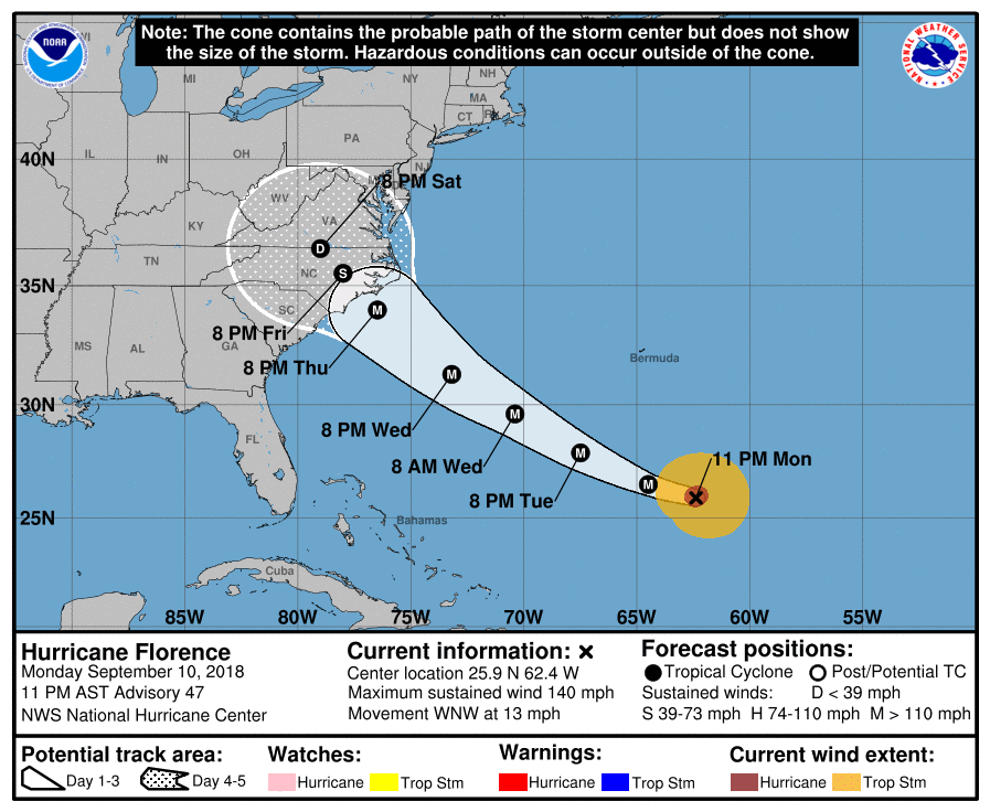
8 hours ago, downeastnc said:
This is where I am, I too think its gonna dump in somewhere between ILM and J'ville, though if the eye is big enough it might be big enough to cover that whole stretch.....it will move WNW inland a bit then stall and then move more NNW and eventually to NNE......and probably spend way to much time over central and eastern NC....there is still around 54 hrs before landfall and there will be another north trend in the models.....
Given the new updates do you still feel that this is a possibility? Obviously feels have nothing to do with weather forecasting but something just doesn’t feel right about all of this.
-
4 minutes ago, downeastnc said:
hard to say....on the current NHC track the center goes 50-60 miles SW of MBY so it will close to that for you as well....and thats the center of the center if its a 20-30 mile wide eye we are talking more like 40 miles to the inner eyewall....I have a hard time believing I only get 56 mph wind gust when a Cat 3 is sitting over Jacksonville with us within 50 miles of the core..... it depends on the structure of the storm too, also the gradient between the cane and the ridge will be a player on the NE side.....every storm is different though....Fran's center was 75-80 miles SW of us here and we gusted to 100 in that one, and I was in the SW eyewall of Isabel and never gusted over 55.
Thanks for the detailed response. I actually moved to Greenville this week so it seems I should be experiencing the same effects from this storm as you are.
I have a love/hate relationship when it comes to tracking these storms, there is too much uncertainty in regards to how it will affect us. What are your opinions on the Euro vs GFS? I might be talking out my butt but I’m think it will likely lie somewhere in the middle. From the last few years it has seemed that the Euro has been more consistent in regards to forecasting storm tracks.
-
With this forecasted to stall as it enters N.C. what will happen to the winds? How quickly will it lose intensity?
-
19 minutes ago, northwestgastormdawg said:
This looks like a worst case scenario for Greenville, NC and Wilmington, NC. They are the two most populated cities in Eastern NC and filled with college students from all over that may not be familiar with how dangerous Hurricanes can be.
I seriously hope something changes in these next few days. This could turn out to be really bad considering most of the college kids in Greenville live in areas that are very prone to flooding.
-
Without a doubt in my mind if there is a chance that this precip will fall as as ZR or Sleet then that is exactly what will happen. There is something about the Pamlico river that screws with the weather. I’m trying not to get my hopes up.


Dorian
in Southeastern States
Posted
Looks like the eye is closing up, not sure how this will affect its strength as it approaches the Carolinas.